Natural Resources
Conservation Service
Ecological site R058CY082ND
Choppy Sands
Last updated: 10/31/2018
Accessed: 12/22/2024
General information
Provisional. A provisional ecological site description has undergone quality control and quality assurance review. It contains a working state and transition model and enough information to identify the ecological site.

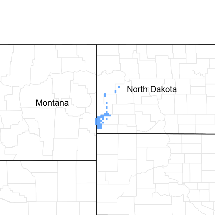
Figure 1. Mapped extent
Areas shown in blue indicate the maximum mapped extent of this ecological site. Other ecological sites likely occur within the highlighted areas. It is also possible for this ecological site to occur outside of highlighted areas if detailed soil survey has not been completed or recently updated.
MLRA notes
Major Land Resource Area (MLRA): 058C–Northern Rolling High Plains, Northeastern Part
MLRA 58C covers 2,780 square miles and encompasses approximately 1.8 million acres. MLRA 58C spans two states with 96% of the area in North Dakota and 4% in Montana. The acreage inside MLRA 58C is 54% privately owned and 44% federal land. The federal land consists of the Fort Berthold Indian Reservation, Little Missouri National Grasslands, and Theodore Roosevelt National Park. MLRA 58C landscape is characterized by steeply sloping, dissected badlands along the Little Missouri River and its tributaries. Tertiary marine shale, siltstone, and sandstone sediments are the most common soil parent materials in this MLRA. Primary land uses are rangeland for grazing and wildlife habitat. Micro-climates inherent in badlands landscapes influence both variety and abundance of vegetation in MLRA 58C. South- and west-facing exposures are dry, hot, and sparsely vegetated. More humid and cooler north- and east-facing exposures are favorable for abundant forage and woody vegetation.
Classification relationships
Major land resource area (MLRA): 058C-Northern Rolling High Plains, Northeastern Part
Ecological site concept
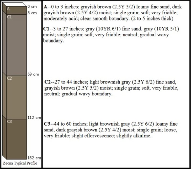
The Choppy Sands ecological site is characterized by sandy soils, generally with greater than 52 percent sand. Sandy eolian and alluvium sediments make up the parent material of this ecological site. The soil surface is generally less than 3 inches thick, but ranges from 2 to 5 inches. This site occurs on hummocky dunes associated with hillslopes mainly in the southern part of MLRA 58C and on natural levees associated with the floodplain of the Little Missouri River. The slopes are generally less than 15 percent giving a short, steep, hummocky appearance of this site.
Associated sites
| R058CY076ND |
Sands The Sands ecological site is on hillslopes that do not receive additional moisture from runoff. The surface layer of the soil on the hillslopes is typically <12 inches. They are deep or very deep and somewhat excessive to excessively drained, carbonates may or may not be present in the soil solum. The soil textures contain high amounts of sand and will not form a ribbon, but may form a ball when squeezed. This ecological site is on backslopes and footslopes similar to Loamy, Sandy, and Clayey ecological sites. Choppy Sands ecological site are on nearby hummocky dunes on the hillslopes. The Sands site has more production than the Choppy Sands ecological site. Indicator species: sand bluestem and prairie sandreed evenly mixed, some Canada wildrye, penstemon, leadplant, and western snowberry. |
|---|---|
| R058CY077ND |
Sandy These are coarse loamy, somewhat excessively to well drained soils on dry hillslopes that do not receive additional moisture from runoff. Soils on Sandy ecological sites are upslope from Sandy Terrace and Loamy Overflow sites, and down slope from Limy Sands and Shallow Sandy sites. Sandy sites are on similar landscape positions as Loamy, Sands, and Clayey ecological sites. The Choppy Sands ecological sites are on nearby hummocky dunes on the hillslopes. Soils on Sandy sites have a high sand content and will make a weak ribbon less than 1 inch long before breaking. The Sandy site has more production then the Choppy Sands ecological site. Indicator species are prairie sandreed with western wheatgrass and green needlegrass intermixed. This site has prairie sandreed and sand bluestem; more needleandthread and sedges, less blue grama, green needlegrass, and western wheatgrass. |
| R058CY088ND |
Shallow Sandy The Shallow Sandy ecological site is on hillslopes. The soils on this ecological site have coarse or moderately coarse textures and are somewhat excessively drained. Soft, sandstone bedrock is between 10 inches and 20 inches below the soil surface. The sandstone beds are a root restrictive layer. The soils on Shallow Sandy sites will form a ribbon less than 1 inch long before breaking. The Shallow Sandy ecological site is upslope from the Choppy Sands ecological site. The Shallow Sandy ecological site has slightly less production than the Choppy Sands ecological site due to its position on droughty shoulder slopes of steep hillslope landforms and the presence of a root restrictive layer above twenty inches. Indicator species are little bluestem, prairie sandreed, sand bluestem, and needle grasses, with dotted gayfeather, pasqueflower, purple coneflower, purple prairie clover, and shrubs like prairie rose and yucca. |
| R058CY089ND |
Sandy Terrace The Sandy Terrace ecological site has well to excessively drained soils on river or stream terraces that will flood occasionally (once in ten years) to rarely (1 to 5 times in 100 years). These floodplain steps generally have a water table that fluctuates with the depth of the water in the river or stream channel. The soils are very deep and have moderately coarse to coarse textures with stratified layers in the subsoil below the surface layer. These landforms receive periodic deposition from occasional flooding events, so carbonates may or may not be present at or near the surface. The Sandy Terrace sites are typically closer to the associated river or stream and on a similar or slightly lower elevation than the Loamy Terrace. The Sandy Terrace site is down slope from Limy Residual, Badland Fan, Loamy, Sandy, Clayey, and Sands ecological sites. The site is upslope from Saline Lowland and Loamy Overflow (“Riparian Complex”) ecological sites. The Choppy Sands ecological site is on nearby hummocky natural levees on floodplains of wind and water worked sediments along the major river system in MLRA 58C. The Sandy Terrace site has more production then the Choppy Sands ecological site. Indicator species are prairie sandreed evenly mixed with sand bluestem, some Canada wildrye, penstemon, and leadplant and/or western snowberry, silver sage, and possibly trees. |
| R058CY095ND |
Limy Sands The Limy Sands ecological site occurs on shoulders and backslopes on hillslopes. The soils typically have a thin surface layer which is usually calcareous within 6 inches of the soil surface. The soils on this site typically is moderately deep (20 to 40 inches) to soft, sedimentary bedrock. There is high amounts of sand in the soil and it may not form a ribbon, but may form a ball when squeezed. This site is downslope from Shallow Sandy and upslope or on a similar slope to the Sands and Sandy ecological sites. Choppy Sands ecological site are on nearby hummocky dunes on the hillslopes. Indicator species: Little bluestem, sand bluestem, and prairie sandreed, along with penstemon, silverleaf scurfpea, purple coneflower, yucca, creeping juniper, and leadplant. |
Table 1. Dominant plant species
| Tree |
Not specified |
|---|---|
| Shrub |
Not specified |
| Herbaceous |
Not specified |
Click on box and path labels to scroll to the respective text.

