Natural Resources
Conservation Service
Ecological site R062XA017SD
Shallow Clayey - North
Last updated: 2/06/2025
Accessed: 04/03/2026
General information
Provisional. A provisional ecological site description has undergone quality control and quality assurance review. It contains a working state and transition model and enough information to identify the ecological site.
MLRA notes
Major Land Resource Area (MLRA): 062X–Black Hills
The Black Hills (MLRA 62) is a unique, low lying mountain range situated in the midst of a mixed short and mid-grass prairie. It is a true Island in the Plains, as it has geophysical and biological attributes that are unlike the surrounding area. The Black Hills have strong floristic ties to four of the North American biomes: Cordilleran (Rocky Mountain) Forest, Northern Coniferous Forest, Eastern Deciduous Forest, and Grasslands.
MLRA 62 is approximately 3,040 square miles in size; 74 percent is located in South Dakota, and 26 percent is in Wyoming. The towns of Lead, Deadwood, Hill City, and Custer, South Dakota, are in this area. U.S. Highways 16 and 385 cross the MLRA. The Black Hills National Forest, Custer State Park, Mt. Rushmore National Monument, Wind Cave National Park, and Jewel Cave National Monument are located in this MLRA.
This area forms the core of the Black Hills and the Bear Lodge Mountains where the elevation ranges between 3,600 to 6,565 feet, however, Black Elk Peak (Harney Peak) rises to 7,242 feet. Slopes range from moderately sloping on some of the high plateaus to very steeply sloping along drainageways and on peaks and ridges. Narrow valleys generally are gently sloping to strongly sloping.
The Black Hills uplift is the product of the Laramide mountain-building episodes that produced most of the ranges in the Rocky Mountains. Uplift began near the end of the Cretaceous period, 65 million years ago and ended by 35 million years ago (Froiland 1990). The core of the Black Hills is a plutonic mass of granite with steeply dipping metamorphic rocks, primarily slate and schist, directly surrounding the granite core. A plateau of Mississippian limestone surrounds the igneous and metamorphic rock core. The Madison limestone is broken around the outer edges of the uplifted area. The Permian Minnekahta limestone forms the outermost boundary of the area. Many other tilted sandstone, shale, and limestone units are exposed like a bathtub ring inside the steeply dipping Madison limestone.
The dominant soil orders in this MLRA are Alfisols (forest soils) and Mollisols (grassland soils). The soils in the area have a frigid or cryic soil temperature regime, a udic or ustic soil moisture regime, and mixed, micaceous, or smectitic mineralogy. They are shallow to very deep, generally well drained, and loamy in texture.
The Black Hills MLRA supports open to dense forest vegetation. Ponderosa pine is the dominant species across the Black Hills. White spruce grows at the higher elevations and along the major drainageways. Bur oak is found intermixed with pine in the northern and eastern fringes of the Black Hills, and Rocky Mountain Juniper is more common in the southern portion of the Black Hills. Aspen and paper birch are minor components found throughout the Black Hills. Prairie dropseed, roughleaf ricegrass, green needlegrass, poverty oatgrass, Richardson’s needlegrass, slender wheatgrass, and Canada wildrye are the most common native grasses under open forest stands. The most common native shrubs are bearberry, common juniper, grouse whortleberry, poison ivy, and Saskatoon serviceberry.
MLRA 62 land ownership is approximately 47 percent private and 53 percent federal. Rangeland and forestland are split almost equally between private and federal ownership (47 percent each). Minor areas of land are privately owned cropland and urban development. The forestland in this area is used mainly for timber production, recreation, and grazing.
The major resource concerns are soil erosion and surface compaction caused by logging, mining, wildfires, grazing, and urban expansion. The quality of ground and surface water is another concern, especially in the northern part of the Black Hills. The primary cause is contamination from mine waste and septic systems in areas of rural development and urban expansion (USDA-NRCS, 2006: Ag Handbook 296).
LRU notes
For development of ecological sites, MLRA 62 is divided into three LRU’s or physiographic zones (A, B, C, and Y). Each LRU has a set of ecological sites that represents these zones.
The LRU is identified in the Ecological Site ID: R062XY000SD; “062X” identifies the MLRA, the next letter “Y” identifies the LRU. Note: The organization of Ecological Site ID’s will likely change in the future.
The North, LRU-A includes the northern Black Hills and Bear Lodge Mountains. It receives between 22 and 30 inches of annual precipitation and has a frigid soil temperature regime.
The High Central, LRU-B includes the high elevation (> 6,200 feet) central core of the Black Hills, which receives between 25 to 35 inches of annual precipitation and has a cryic soil temperature regime.
The South, LRU-C includes the southern portion of the Black Hills and receives between 17 to 21 inches of annual precipitation and has a frigid soil temperature regime.
One additional grouping of ecological sites that are common to the entire MLRA are designated with a “Y” in the ecological site ID.
Classification relationships
USDA
Land Resource Region G—Western Great Plains Range and Irrigated Region:
Major Land Resource Area (MLRA) 62—Black Hills
US Environmental Protection Agency (EPA)
Level IV Ecoregions of the Conterminous United States:
Black Hills Plateau—17b
Black Hills Core Highlands—17c
USDA Forest Service
Ecological Subregions: Sections and Subsections of Conterminous United States:
Black Hills Coniferous Forest Province—M334:
Black Hills Section—334A
Black Hills Limestone Plateau-Core Highlands Subsection—M334Ab
Ecological site concept
The Shallow Clayey - North ecological site occurs primary in the Bear Lodge Mountains of Wyoming. It is located on upland landscapes and does not receive additional moisture from runoff or overflow. The typical slopes range is from 2 to 40 percent. Soils are shallow, (between 10 and 20 inches) with surface textures ranging from clay to silty clay. The surface layer is 3 to 5 inches deep. Subsurface textures range from clay to silty clay with many weathered shale chips.
The vegetation in the Reference State (1.0) consists of a mix of cool- and warm-season grasses, cool-season rhizomatous wheatgrass, needlegrasses, and warm-season bunchgrasses will be the dominant groups. Forbs are common and diverse. Shrubs will include rose, skunkbush sumac, and silver sagebrush. Ponderosa pine and bur oak may be found scattered across the site.
Associated sites
| R062XY012SD |
Thin Upland The Thin Upland ecological site is found on steeper slopes adjacent to or up slope of the Shallow Clayey - North ecological site. |
|---|---|
| R062XA011SD |
Clayey - North The Clayey - North ecological site is found on less steep slopes; landscape positions below or adjacent to the Shallow Clayey - North ecological site. |
| R062XA010SD |
Loamy - North The Loamy - North ecological site is found on less steep slopes; landscape positions below or adjacent to the Shallow Clayey - North ecological site. |
Similar sites
| R062XY012SD |
Thin Upland The Thin Upland ecological site will not have a root restrictive layer; will have less needlegrass, and more big and little bluestem than the Shallow Clayey - North ecological site. |
|---|---|
| R062XA011SD |
Clayey - North The Clayey - North ecological site will not have a root restrictive layer; will have more cool-season grasses, and greater vegetative production than the Shallow Clayey - North ecological site. |
Table 1. Dominant plant species
| Tree |
Not specified |
|---|---|
| Shrub |
Not specified |
| Herbaceous |
(1) Pascopyrum smithii |
Physiographic features
The Shallow Clayey - North ecological site occurs on gently sloping to very steep hills, ridges, and backslopes in the Bear Lodge Mountains. Slopes typically range from 2 to 30 percent, but may exceed 30 percent in some areas.
Table 2. Representative physiographic features
| Landforms |
(1)
Ridge
(2) Hillslope |
|---|---|
| Runoff class | High to very high |
| Elevation | 3,800 – 5,500 ft |
| Slope | 2 – 40% |
| Water table depth | 80 in |
| Aspect | Aspect is not a significant factor |
Climatic features
MLRA 62 is in a microclimate caused by the influence of increased elevation which leads to increased precipitation, moderate air temperature, and lower wind velocities as compared to the surrounding Great Plains. In general, the Black Hills climate is a continental type, cold in the winter and hot in the summer.
Annual precipitation in MLRA 62 typically increases with elevation and decreases from west to east and from north to south. The average annual precipitation range for MLRA 62 is 17 to 35 inches. Most of the rainfall occurs as frontal storms early in the growing season, in May and June. Some high-intensity, convective thunderstorms occur in July and August. Precipitation in the winter occurs mostly as snow. Twenty to forty percent of the annual precipitation falls as snow. The annual average snowfall ranges from 23 inches at the lower elevations in the south, to 54 inches in the higher elevations of the central core of the Black Hills.
The average annual temperature ranges from 36°F to 48°F. January is the coldest month, with an average temperature of 22°F in the higher elevation of the central core, and 25°F in the southern part of MLRA 62. July is the warmest month, with an average daily temperature of 67°F in the central core, and 73°F in the southern part of this MLRA. The frost-free period ranges from 129 to 168 days. It is shortest at higher elevations and in the northwestern part of the MLRA. Hourly winds are estimated to average about 11 miles per hour (mph) annually.
The average annual precipitation range for LRU-A (Northern Black Hills and Bear Lodge Mountains) is 22 to 30 inches. The estimated average annual precipitation for the Bear Lodge Mountains is 19 to 22 inches. This is an estimate as there are no weather stations located within the Bear Lodge Mountains.
Growth of cool-season plants begins in April, slowing or ceasing growth by mid-August. Warm-season plants begin growth in May and continue to mid-September. Regrowth of cool-season plants may occur in September and October, depending upon soil moisture availability.
Table 3. Representative climatic features
| Frost-free period (characteristic range) | 98-108 days |
|---|---|
| Freeze-free period (characteristic range) | 124-139 days |
| Precipitation total (characteristic range) | 20-21 in |
| Frost-free period (actual range) | 95-111 days |
| Freeze-free period (actual range) | 120-143 days |
| Precipitation total (actual range) | 19-22 in |
| Frost-free period (average) | 103 days |
| Freeze-free period (average) | 132 days |
| Precipitation total (average) | 21 in |
Figure 1. Monthly precipitation range
Figure 2. Monthly minimum temperature range
Figure 3. Monthly maximum temperature range
Figure 4. Monthly average minimum and maximum temperature
Figure 5. Annual precipitation pattern
Figure 6. Annual average temperature pattern
Climate stations used
-
(1) SUNDANCE [USC00488705], Sundance, WY
-
(2) BEAR RIDGE [USC00390554], Spearfish, SD
Influencing water features
No riparian areas or wetland features are directly associated with the Shallow Clayey - North ecological site.
Soil features
Soils common to the Shallow Clayey – North ecological site are shallow (10 and 20 inches deep) and well drained. The surface layer averages 3 to 5 inches in thickness. Surface and subsurface textures are clay or silty clay. The soils are typically calcareous but may be leached a few inches. Bedrock, usually consisting of weakly cemented shale or shale and siltstone, occurs at 10 to 20 inches and can be restrictive to water movement and root penetration. Representative soils of this ecological site have a frigid temperature regime.
The primary soil correlated to the Shallow Clayey - North ecological site is Samsil.
These soils are mainly susceptible to water erosion. The hazard of water erosion increases as slope increases. Rill erosion is probably the most common form that occurs on this site, and occurs to a minor extent even under pristine conditions. Rills tend to form under prolonged exposure of the surface of the soil. Rills are typically shallow in depth and narrow, but may occur every 6 to 12 inches. On steeper soils, rills may converge in areas of concentrated flow, forming gullies. Loss of 50 percent or more of the surface layer of the soils on this site can result in a shift in species composition and/or production.
More information can be found in the various soil survey reports. Contact the local USDA Service Center for soil survey reports that include more detail specific to your area of interest, or use the internet to access USDA’s Web Soil Survey.
Table 4. Representative soil features
| Parent material |
(1)
Residuum
–
shale
(2) Residuum – claystone |
|---|---|
| Surface texture |
(1) Clay (2) Silty clay |
| Family particle size |
(1) Clayey |
| Drainage class | Well drained |
| Permeability class | Slow to very slow |
| Soil depth | 10 – 20 in |
| Surface fragment cover <=3" | 5% |
| Surface fragment cover >3" | 2% |
| Available water capacity (Depth not specified) |
1 – 3 in |
| Calcium carbonate equivalent (Depth not specified) |
10% |
| Electrical conductivity (Depth not specified) |
4 mmhos/cm |
| Sodium adsorption ratio (Depth not specified) |
5 |
| Soil reaction (1:1 water) (Depth not specified) |
6.6 – 8.4 |
| Subsurface fragment volume <=3" (Depth not specified) |
15% |
| Subsurface fragment volume >3" (Depth not specified) |
Not specified |
Ecological dynamics
The Shallow Clayey - North ecological site developed under climatic conditions in and around the Bear Lodge Mountains; light to severe grazing by bison, elk, insects, and small mammals; sporadic, natural or human-caused wildfire (often of light intensities); and other biotic and abiotic factors that typically influence soil and site development. Changes occur in the plant communities due to short-term weather variations, effects of native and exotic plant and animal species, and management actions. Severe disturbances, such as periods of well-below average precipitation, severe defoliation, or non-use and no fire can cause significant shifts in plant communities and species composition.
Continuous season-long grazing (grazing during the typical growing season of May through October at moderate to heavy stocking levels for the full growing season each year without adequate recovery periods following each grazing occurrence) or continuous seasonal grazing (e.g., grazing every spring or every summer at moderate to heavy stocking levels without adequate recovery periods following grazing events) will cause a departure from the Western Wheatgrass-Green Needlegrass-Little Bluestem Plant Community (1.1). Needlegrasses will begin to decrease in frequency and production, and sideoats grama, blue grama and sedge will increase. Because of the predominance of non-native cool-season grasses, Kentucky bluegrass and smooth brome will invade and become established in the plant community with continuous seasonal grazing or extended periods of non-use and no fire. Excessive defoliation can cause threeawn and annuals to increase and dominate the site. Long-term no fire and the encroachment and establishment of conifer trees will shift the site to a conifer dominated plant community.
Interpretations are primarily based on the Western Wheatgrass-Green Needlegrass-Little Bluestem Plant Community (1.1). It has been determined by study of rangeland relic areas, areas protected from excessive disturbance, and areas under long-term rotational grazing regimes. Trends in plant community dynamics ranging from heavily grazed to lightly grazed areas, seasonal use pastures, and historical accounts also have been used. Plant community phases, states, transitional pathways, and thresholds have been determined through similar studies and experience.
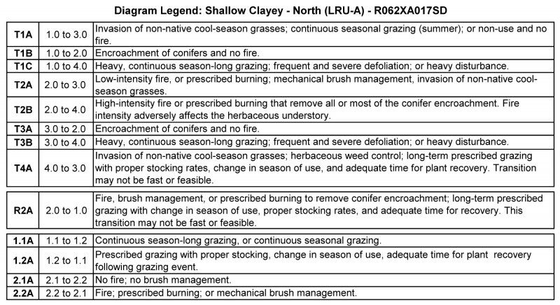
The following is a State-and-Transition diagram that illustrates the common plant communities that can occur on the site and the transition pathways between communities. The ecological processes will be discussed in more detail in the plant community descriptions following the diagram.
State and transition model
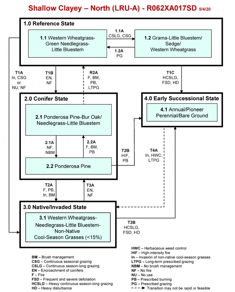
More interactive model formats are also available.
View Interactive Models
Click on state and transition labels to scroll to the respective text
State 1 submodel, plant communities
State 2 submodel, plant communities
State 3 submodel, plant communities
State 4 submodel, plant communities
State 1
Reference State
The Reference State represents what is believed to show the natural range of variability that dominated the dynamics of the ecological site prior to European settlement. This site in the Reference State (1.0) is dominated by cool-season grasses and subdominant warm-season grasses. Grazing or the lack of grazing, and occasional fire are the major drivers between plant communities. Heavy, continuous season-long grazing can push this state to an annual and pioneer perennial State (4.0). Non-use, no fire, and invasion of non-native cool-season grasses will result in a transition to a Native/Invaded State (3.0). Long-term fire suppression and conifer encroachment can transition the Reference State (1.0) to the Conifer State (2.0).
Dominant plant species
-
ponderosa pine (Pinus ponderosa), tree
-
bur oak (Quercus macrocarpa), tree
-
fragrant sumac (Rhus aromatica), shrub
-
leadplant (Amorpha canescens), shrub
-
western wheatgrass (Pascopyrum smithii), grass
-
green needlegrass (Nassella viridula), grass
-
American vetch (Vicia americana), other herbaceous
-
dotted blazing star (Liatris punctata), other herbaceous
Community 1.1
Western Wheatgrass-Green Needlegrass-Little Bluestem
Interpretations are based primarily on the Western Wheatgrass-Green Needlegrass-Little Bluestem Plant Community, which is also considered to be Reference Plant Community (1.1). The potential vegetation is about 80 percent grasses or grass-like plants, 10 percent forbs, and 10 percent shrubs and trees. The community is dominated by a mix of cool- and warm-season grasses. The major grasses include western wheatgrass, green needlegrass, little bluestem, sideoats grama, and needle and thread. Other grass and grass-like species include big bluestem, bluebunch wheatgrass, blue grama, and threadleaf sedge. Common forbs include American vetch, dotted gayfeather, goldenrod, scurfpea, and purple prairie clover. Skunkbush sumac, leadplant, fringed sagewort, rose, and silver sagebrush are common shrubs. Ponderosa pine and bur oak are likely scatter across this site. This plant community is resilient and well adapted to the Northern Black Hills climatic conditions. The diversity in plant species allows for high drought tolerance. This is a sustainable plant community in regard to site and soil stability, watershed function, and biologic integrity.
Figure 7. Annual production by plant type (representative values) or group (midpoint values)
Table 5. Annual production by plant type
| Plant type | Low (lb/acre) |
Representative value (lb/acre) |
High (lb/acre) |
|---|---|---|---|
| Grass/Grasslike | 1040 | 1385 | 1715 |
| Forb | 80 | 170 | 275 |
| Shrub/Vine | 80 | 128 | 175 |
| Tree | 0 | 17 | 35 |
| Total | 1200 | 1700 | 2200 |
Figure 8. Plant community growth curve (percent production by month). SD6202, Black Hills, cool-season dominant, warm-season sub-dominant. Cool-season dominant, warm-season sub-dominant.
| Jan | Feb | Mar | Apr | May | Jun | Jul | Aug | Sep | Oct | Nov | Dec |
|---|---|---|---|---|---|---|---|---|---|---|---|
| J | F | M | A | M | J | J | A | S | O | N | D |
| 0 | 0 | 3 | 10 | 23 | 34 | 15 | 6 | 5 | 4 | 0 | 0 |
Community 1.2
Grama-Little Bluestem/Sedge/Western Wheatgrass
This plant community evolved under continuous seasonal grazing (grazing at moderate to heavy stocking levels at the same time of year each year), or continuous season-long grazing (grazing at moderate to heavy stocking levels for the full growing season each year without adequate recovery periods following each grazing occurrence). The potential plant community is made up of approximately 80 percent grasses or grass-like plants, 10 percent forbs, and 10 percent shrubs and trees. Dominant grass and grass-like species include sideoats grama, blue grama, little bluestem, threadleaf sedge, and western wheatgrass. Grasses of secondary importance include green needlegrass, needle and thread, and prairie Junegrass. Forbs commonly found in this plant community include white sagebrush (cudweed sagewort), prairie coneflower, goldenrod, and western yarrow. Skunkbush sumac, leadplant, fringed sagewort, rose, and silver sagebrush are common shrubs. Ponderosa pine and bur oak are likely scattered across this site. When compared to the Western Wheatgrass-Green Needlegrass-Little Bluestem Plant Community (1.1), sideoats grama, blue grama and threadleaf sedge have increased. Green needlegrass, needle and thread, and western wheatgrass have decreased. This plant community is moderately resistant to change. The herbaceous species present are well adapted to grazing; however, species composition can be altered through long-term overgrazing. If the herbaceous component is intact, it tends to be resilient if the disturbance is not long-term. The hydrologic function of the site is beginning to be altered with the potential increase in bare ground.
Figure 9. Plant community growth curve (percent production by month). SD6203, Black Hills, cool-season/warm-season co-dominant. Cool-season/warm-season co-dominant.
| Jan | Feb | Mar | Apr | May | Jun | Jul | Aug | Sep | Oct | Nov | Dec |
|---|---|---|---|---|---|---|---|---|---|---|---|
| J | F | M | A | M | J | J | A | S | O | N | D |
| 0 | 0 | 3 | 10 | 20 | 28 | 21 | 10 | 5 | 3 | 0 | 0 |
Pathway 1.1A
Community 1.1 to 1.2
Continuous seasonal grazing which includes grazing at moderate to heavy stocking levels at the same time of year each year, or continuous season-long grazing will shift the Western Wheatgrass-Green needlegrass-Little Bluestem Plant Community (1.1) to the Grama-Little Bluestem/Sedge/Western Wheatgrass Plant Community (1.2).
Pathway 1.2A
Community 1.2 to 1.1
Prescribed grazing with proper stocking rates, alternating season of use, and providing adequate recovery periods, including periodic light to moderate grazing possibly periodic rest will shift the Grama-Little Bluestem/Sedge/Western Wheatgrass Plant Community (1.2) to the Western Wheatgrass-Green Needlegrass-Little Bluestem Plant Community (1.1).
Conservation practices
| Prescribed Grazing |
|---|
State 2
Conifer State
This Conifer State consists of areas where tree canopy increases to a level that impedes the reproductive capability of the major native perennial grass species. The increase in conifer canopy is a result of encroachment from forest sites, or from rangeland sites that have been invaded, and the disruption of the natural historic fire regime that maintained conifer trees in an immature stage. This state is reached when mature conifer canopy reaches approximately 25 percent or more. The canopy typically is dominated by ponderosa pine, but bur oak and Rocky Mountain juniper may also be present in varying amounts. With continued long-term fire suppression and no brush management, the conifer canopy can eventually become closed with much of the herbaceous understory lost. This loss is partly driven by the interception of precipitation. Ponderosa pine canopy can significantly reduce precipitation reaching the ground due to canopy interception. In areas with intermediate and dense canopy’s, the expected reduction can reach 30 percent (Wrage, 1994).
Dominant plant species
-
ponderosa pine (Pinus ponderosa), tree
-
bur oak (Quercus macrocarpa), tree
-
fragrant sumac (Rhus aromatica), shrub
-
common snowberry (Symphoricarpos albus), shrub
-
green needlegrass (Nassella viridula), grass
-
needle and thread (Hesperostipa comata), grass
-
prairie sagewort (Artemisia frigida), other herbaceous
-
white prairie aster (Symphyotrichum falcatum), other herbaceous
Community 2.1
Ponderosa Pine-Bur Oak/Needlegrass-Little Bluestem
This plant community develops where trees from adjacent sites encroach or trees naturally occurring on the site increase and begin to shade out the herbaceous component. Ponderosa pine is the most common species to occupy the site, but bur oak and possibly Rocky Mountain juniper have the potential to occur. These species expand on this site due to suppression of fire and no brush management. The mature tree canopy is 25 percent or greater. The potential plant community is made up of approximately 50 percent grasses and grass-like species, 10 percent forbs, 10 percent shrubs, and 30 percent trees. Dominant grass and grass-like species include green needlegrass, needle and thread, little bluestem, and western wheatgrass. As the conifer canopy increases, native cool-season grasses will tend to decrease, and more shade-tolerant non-native cool-season grasses invade and increase. Forbs commonly found in this community include cudweed sagewort, white prairie aster, silverleaf scurfpea, and pussytoes. Shrubs will include skunkbush sumac, snowberry, and rose. A significant reduction of tree canopy can be accomplished through fire, mechanical brush management, or prescribed burning. The vegetation in the understory is capable of enduring fire; however, very hot crown fires will have a detrimental effect to the whole plant community.
Figure 10. Plant community growth curve (percent production by month). SD6211, Black Hills, heavy conifer canopy. Mature ponderosa pine overstory.
| Jan | Feb | Mar | Apr | May | Jun | Jul | Aug | Sep | Oct | Nov | Dec |
|---|---|---|---|---|---|---|---|---|---|---|---|
| J | F | M | A | M | J | J | A | S | O | N | D |
| 1 | 3 | 7 | 11 | 24 | 27 | 12 | 5 | 4 | 3 | 2 | 1 |
Community 2.2
Ponderosa Pine
This plant community is a result of continued suppression of fire and no brush management. The tree canopy eventually becomes closed and most of the herbaceous understory is lost. Mature tree canopy approaches 45 percent or higher and competition slows the growth rate of the trees. A few cool-season species may survive, as well as, shrubs and possibly vines. This plant community may only be altered through brush management or possibly a wildfire that has enough energy to cause crowning of the trees. This plant community phase will also be accompanied by a relatively thick layer of acidic duff from the needles of the trees which will further reduce the establishment of herbaceous species.
Pathway 2.1A
Community 2.1 to 2.2
No fire or no brush treatment for an extended period of time will cause the tree canopy to continue to increase and shift the Ponderosa Pine-Bur Oak/Needlegrass-Little Bluestem Plant Community (2.1) to the Ponderosa Pine Plant Community (2.2).
Pathway 2.2A
Community 2.2 to 2.1
Fire; brush management; or prescribed burning will be required to shift this plant community away from this phase. Reproductive propagules of native herbaceous species will need to be present to result in a shift from the Ponderosa Pine Plant Community (2.2) to the Ponderosa Pine-Bur Oak/Needlegrass-Little Bluestem Plant Community (2.1).
Conservation practices
| Brush Management | |
|---|---|
| Prescribed Burning |
State 3
Native/Invaded State
The Native/Invaded State is dominated by native cool- and warm-season grasses, and subdominant non-native cool-season grasses (< 15 percent composition by weight). It can be found on areas that would appear to be properly managed with grazing and possibly prescribed burning. Extended periods of non-use and no fire, or long-term light grazing can result in the invasion and establishment of non-native cool-season grasses on this site. As native cool-season grasses decline a corresponding increase of non-native cool-season grasses will occur. The non-native cool-season grasses will include, smooth brome, Kentucky bluegrass, cheatgrass, and field brome. Forbs will be common and diverse. Shrubs will include fringed sagewort, rose, silver sagebrush, and western snowberry. Scattered ponderosa pine and bur oak will be found across this site. This a sustainable state in regard to site and soil stability, and watershed function.
Dominant plant species
-
ponderosa pine (Pinus ponderosa), tree
-
bur oak (Quercus macrocarpa), tree
-
fragrant sumac (Rhus aromatica), shrub
-
prairie sagewort (Artemisia frigida), shrub
-
western wheatgrass (Pascopyrum smithii), grass
-
green needlegrass (Nassella viridula), grass
-
white sagebrush (Artemisia ludoviciana), other herbaceous
-
prairie coneflower (Ratibida), other herbaceous
Community 3.1
Western Wheatgrass-Needlegrass-Little Bluestem-Non-Native Cool-Season Grasses (< 15%)
This plant community develops when non-native cool-season grasses, such as Kentucky bluegrass and smooth brome invade and become established on the site. This may occur due to the sites close proximity to seed sources, expansion from road ditches, improved pastures, other invaded sites, and from contaminated hay. Repeated seasonal grazing (typically during the summer), or long-term light grazing, or extended periods of non-use and no fire, will allow these non-native cool-season grasses to increase in the plant community. Plant litter will accumulate in large amounts when this community first develops. Litter buildup reduces mature native plant vigor and density, and seedling recruitment declines. Eventually litter levels become high enough that plant density decreases. Typically, rhizomatous grasses form small colonies because of a lack of tiller stimulation. The potential vegetation is about 80 percent grasses or grass-like plants, 10 percent forbs, and 10 percent shrubs and trees. The community is dominated by cool-season grasses. The major grasses include western wheatgrass, green needlegrass, needle and thread, Kentucky bluegrass, and smooth brome. Other grass and grass-like species include little bluestem, sideoats grama, bluebunch wheatgrass, slender wheatgrass, and sedges. Forbs commonly found in this plant community include white sagebrush (cudweed sagewort), prairie coneflower, goldenrod, and western yarrow. Shrubs will include skunkbrush sumac, fringed sagewort, rose, silver sagebrush, and western snowberry. Scattered ponderosa pine and bur oak will be found across this site. This plant community is resilient and well adapted to the Northern Black Hills climatic conditions. The non-native species typically do not increase to the point of dominance; however, their presence tends to reduce the overall diversity of the plant community. As such, this is a somewhat sustainable plant community in regard to site and soil stability, watershed function, and biologic integrity.
Figure 11. Plant community growth curve (percent production by month). SD6201, Black Hills, cool-season dominant. Cool-season dominant.
| Jan | Feb | Mar | Apr | May | Jun | Jul | Aug | Sep | Oct | Nov | Dec |
|---|---|---|---|---|---|---|---|---|---|---|---|
| J | F | M | A | M | J | J | A | S | O | N | D |
| 0 | 0 | 4 | 12 | 25 | 36 | 10 | 5 | 4 | 4 | 0 | 0 |
State 4
Early Successional State
This state occurs as a result of extreme disturbance that typically removes most of the native species normally present on this site. Disturbance in the form of high-intensity fire; and heavy to severe grazing over several years are the most typical disturbances. The dominant species present is highly variable, but the common characteristics include high amounts of bare ground, reduced soil aggregate stability, increased runoff and increased erosion (including increased sediment loads in the runoff). Restoration of the ecological processes will be very difficult.
Dominant plant species
-
prairie sagewort (Artemisia frigida), shrub
-
broom snakeweed (Gutierrezia sarothrae), shrub
-
threeawn (Aristida), grass
-
cheatgrass (Bromus tectorum), grass
-
fetid marigold (Dyssodia papposa), other herbaceous
-
sweetclover (Melilotus), other herbaceous
Community 4.1
Annual/Pioneer Perennial, Bare Ground
This plant community developed under high-intensity fire; heavy, continuous season-long grazing(grazing at stocking levels well above sustainable carrying capacity for extended portions of the growing season, and at the same time of year each year, without adequate recovery periods following each grazing occurrence); frequent and severe defoliation, or other heavy disturbances, including livestock or wildlife concentration areas. The potential plant community is made up of approximately 60 to 80 percent grasses and grass-like species, 15 to 35 percent forbs, and 2 to 10 percent shrubs and trees. The dominant grass is often threeawn. Other grasses may include cheatgrass, field brome, sedge, blue grama, sand dropseed, bluegrass, and western wheatgrass. The dominant forbs include fetid marigold, sweetclover, Cumin ragweed, white sagebrush (cudweed sagewort), and other invader-like species. The dominant shrubs include fringed sagewort, and broom snakeweed. A wide variety of other early successional plant species can occupy this site in varying amounts. This plant community is susceptible to invasion of Canada thistle and other non-native species because of the relatively high percent of bare ground. Compared to the Western Wheatgrass-Green Needlegrass-Little Bluestem Plant Community (1.1), threeawn, annual brome grasses, and percent of bare ground has increased. Western wheatgrass, needlegrasses and other cool-season grasses have decreased as have the warm-season species including sideoats grama, and little bluestem. Plant diversity is low (plant richness may be high, but areas are often dominated by a few species). The ecological processes are difficult to restore because of the loss of plant diversity and overall soil disturbance. Soil erosion is potentially very high because of the bare ground and shallow rooted herbaceous plant community. Water runoff will increase, and infiltration will decrease due to animal related soil compaction and loss of root mass due to low plant diversity and vigor. This plant community will require significant economic inputs and time to move towards another plant community. This movement is highly variable in its succession. This is due to the loss of diversity (including the loss of the seed bank), within the existing plant community, and the plant communities on adjacent sites.
Transition T1B
State 1 to 2
Long-term no fire and the encroachment and establishment of conifers will transition the Reference State (1.0) to the Conifer State (2.0).
Transition T1A
State 1 to 3
The invasion of non-native cool-season grasses; continuous seasonal grazing (stocking levels above carrying capacity for extended portions of the growing season, and at the same time of year each year, typically beginning early in the growing season); or no use and no fire will transition the Reference State (1.0) to the Native/Invaded State (3.0).
Transition T1C
State 1 to 4
Heavy, continuous season-long grazing; frequent and severe defoliation; or heavy disturbance areas such as livestock or wildlife concentration areas will transition the Reference State (1.0) to the Early Successional State (4.0).
Restoration pathway R2A
State 2 to 1
Fire; prescribed burning; or mechanical brush management in conjunction with long-term prescribed grazing may lead the Conifer State (2.0) across a threshold back to the Reference State (1.0). This transition will need to take place before the trees reach maturity and are still susceptible to fire, and reproductive propagules of the perennial grasses are still present. This transition is most likely to originate from Plant Community 2.1.
Conservation practices
| Brush Management | |
|---|---|
| Prescribed Burning | |
| Prescribed Grazing |
Transition T2A
State 2 to 3
Invasion of non-native cool-season grasses; low-intensity fire, prescribed burning, or mechanical brush management to treat conifer encroachment on this site will transition the Conifer State (2.0) to the Native/Invaded State (3.0). This transition is most likely to originate from Plant Community 2.1.
Conservation practices
| Brush Management | |
|---|---|
| Prescribed Burning |
Transition T2B
State 2 to 4
High-intensity fire or prescribed burning that removes all or most of the conifer encroachment, and adversely affects the herbaceous understory will likely transition the Conifer State (2.0) to the Early Successional State (4.0).
Transition T3A
State 3 to 2
Long-term no fire and the encroachment and establishment of conifers will transition the Native/Invaded State (3.0) to the Conifer State (2.0).
Transition T3B
State 3 to 4
Heavy, continuous season-long grazing; frequent and severe defoliation; or heavy disturbance will transition the Native/Invaded State (3.0) to the Early Successional State (4.0).
Transition T4A
State 4 to 3
The invasion of non-native cool-season perennial grasses; possibly herbaceous weed control; and long-term prescribed grazing with proper stocking rates, change in season of use, and adequate time for plant recovery will transition the Early Successional State (4.0) towards the Native/Invaded State (3.0). This transition could require significant time and inputs to achieve and, in the end, may not meet management objectives.
Conservation practices
| Prescribed Grazing | |
|---|---|
| Herbaceous Weed Control |
Additional community tables
Table 6. Community 1.1 plant community composition
| Group | Common name | Symbol | Scientific name | Annual production (lb/acre) | Foliar cover (%) | |
|---|---|---|---|---|---|---|
|
Grass/Grasslike
|
||||||
| 1 | Rhizomatous Wheatgrass | 340–680 | ||||
| western wheatgrass | PASM | Pascopyrum smithii | 255–510 | – | ||
| thickspike wheatgrass | ELLAL | Elymus lanceolatus ssp. lanceolatus | 85–170 | – | ||
| 2 | Cool-Season Bunchgrass | 85–510 | ||||
| green needlegrass | NAVI4 | Nassella viridula | 85–340 | – | ||
| needle and thread | HECOC8 | Hesperostipa comata ssp. comata | 0–85 | – | ||
| bluebunch wheatgrass | PSSP6 | Pseudoroegneria spicata | 0–85 | – | ||
| porcupinegrass | HESP11 | Hesperostipa spartea | 0–85 | – | ||
| slender wheatgrass | ELTR7 | Elymus trachycaulus | 17–85 | – | ||
| timber oatgrass | DAIN | Danthonia intermedia | 0–85 | – | ||
| slender wheatgrass | ELTRS | Elymus trachycaulus ssp. subsecundus | 17–85 | – | ||
| onespike danthonia | DAUN | Danthonia unispicata | 0–34 | – | ||
| 3 | Tall Warm-Season Grasses | 17–170 | ||||
| big bluestem | ANGE | Andropogon gerardii | 17–170 | – | ||
| prairie sandreed | CALO | Calamovilfa longifolia | 0–51 | – | ||
| composite dropseed | SPCOC2 | Sporobolus compositus var. compositus | 0–51 | – | ||
| 4 | Mid- Warm-Season Grasses | 85–255 | ||||
| little bluestem | SCSC | Schizachyrium scoparium | 34–170 | – | ||
| sideoats grama | BOCU | Bouteloua curtipendula | 34–170 | – | ||
| prairie dropseed | SPHE | Sporobolus heterolepis | 0–85 | – | ||
| 5 | Short Warm-Season Grasses | 17–85 | ||||
| blue grama | BOGR2 | Bouteloua gracilis | 17–85 | – | ||
| buffalograss | BODA2 | Bouteloua dactyloides | 0–34 | – | ||
| threeawn | ARIST | Aristida | 0–34 | – | ||
| 6 | Other Native Grasses | 34–85 | ||||
| Grass, perennial | 2GP | Grass, perennial | 0–68 | – | ||
| prairie Junegrass | KOMA | Koeleria macrantha | 17–51 | – | ||
| Cusick's bluegrass | POCU3 | Poa cusickii | 17–34 | – | ||
| Sandberg bluegrass | POSE | Poa secunda | 0–17 | – | ||
| 7 | Grass-Likes | 34–85 | ||||
| needleleaf sedge | CADU6 | Carex duriuscula | 17–85 | – | ||
| threadleaf sedge | CAFI | Carex filifolia | 17–85 | – | ||
| Grass-like (not a true grass) | 2GL | Grass-like (not a true grass) | 0–51 | – | ||
| 8 | Non-Native Cool-Season Grasses | 0 | ||||
|
Forb
|
||||||
| 9 | Forbs | 85–255 | ||||
| Forb, perennial | 2FP | Forb, perennial | 17–68 | – | ||
| scarlet beeblossom | GACO5 | Gaura coccinea | 0–34 | – | ||
| scarlet globemallow | SPCO | Sphaeralcea coccinea | 17–34 | – | ||
| silverleaf Indian breadroot | PEAR6 | Pediomelum argophyllum | 17–34 | – | ||
| slimflower scurfpea | PSTE5 | Psoralidium tenuiflorum | 17–34 | – | ||
| white prairie aster | SYFA | Symphyotrichum falcatum | 17–34 | – | ||
| leafy wildparsley | MUDI | Musineon divaricatum | 17–34 | – | ||
| white sagebrush | ARLU | Artemisia ludoviciana | 17–34 | – | ||
| desert biscuitroot | LOFO | Lomatium foeniculaceum | 17–34 | – | ||
| dotted blazing star | LIPU | Liatris punctata | 17–34 | – | ||
| prairie thermopsis | THRH | Thermopsis rhombifolia | 17–34 | – | ||
| goldenrod | SOLID | Solidago | 17–34 | – | ||
| beardtongue | PENST | Penstemon | 17–34 | – | ||
| prairie clover | DALEA | Dalea | 17–34 | – | ||
| upright prairie coneflower | RACO3 | Ratibida columnifera | 17–34 | – | ||
| American vetch | VIAM | Vicia americana | 17–34 | – | ||
| bluebells | MERTE | Mertensia | 0–17 | – | ||
| cinquefoil | POTEN | Potentilla | 0–17 | – | ||
| blacksamson echinacea | ECAN2 | Echinacea angustifolia | 0–17 | – | ||
| bellflower | CAMPA | Campanula | 0–17 | – | ||
| buckwheat | ERIOG | Eriogonum | 0–17 | – | ||
| fleabane | ERIGE2 | Erigeron | 0–17 | – | ||
| spiderwort | TRADE | Tradescantia | 0–17 | – | ||
| Cuman ragweed | AMPS | Ambrosia psilostachya | 0–17 | – | ||
| western yarrow | ACMIO | Achillea millefolium var. occidentalis | 0–17 | – | ||
| Forb, introduced | 2FI | Forb, introduced | – | – | ||
|
Shrub/Vine
|
||||||
| 10 | Shrubs | 85–170 | ||||
| rose | ROSA5 | Rosa | 17–68 | – | ||
| skunkbush sumac | RHTR | Rhus trilobata | 17–68 | – | ||
| prairie sagewort | ARFR4 | Artemisia frigida | 17–51 | – | ||
| leadplant | AMCA6 | Amorpha canescens | 0–51 | – | ||
| Wyoming big sagebrush | ARTRW8 | Artemisia tridentata ssp. wyomingensis | 0–51 | – | ||
| Shrub (>.5m) | 2SHRUB | Shrub (>.5m) | 0–34 | – | ||
| silver sagebrush | ARCA13 | Artemisia cana | 17–34 | – | ||
| western snowberry | SYOC | Symphoricarpos occidentalis | 0–34 | – | ||
| rubber rabbitbrush | ERNA10 | Ericameria nauseosa | 0–34 | – | ||
| soapweed yucca | YUGL | Yucca glauca | 0–17 | – | ||
|
Tree
|
||||||
| 11 | Trees | 0–34 | ||||
| ponderosa pine | PIPO | Pinus ponderosa | 0–34 | – | ||
| bur oak | QUMA2 | Quercus macrocarpa | 0–34 | – | ||
| Rocky Mountain juniper | JUSC2 | Juniperus scopulorum | 0–17 | – | ||
Interpretations
Animal community
Wildlife Interpretations
The Black Hills and Bear Lodge Mountains of South Dakota and Wyoming are truly a forested island in a grassland sea. To regional Native Americans, they are ‘Paha Sapa” or “hills that are black”, and from a distance, the ponderosa pine-covered slopes do appear like black hills (Larson, 1999).
The Black Hills and Bear Lodge Mountains are located in the drier areas of a northern mixed-grass prairie ecosystem in which sagebrush steppes to the west yield to grassland steppes to the east. Prior to European settlement, MLRA 62 consisted of diverse grassland, shrubland, and forest habitats interspersed with varying densities of depressional, instream wetlands and woody riparian corridors. These habitats provided critical life cycle components for many users. Many species of grassland birds, small mammals, reptiles, and amphibians and herds of roaming bison, elk, and pronghorn were among the inhabitants adapted to this semi-arid region. Roaming herbivores, as well as several species of small mammals and insects, were the primary consumers linking the grassland resources to large predators, such as the wolf, mountain lion, and grizzly bear, and to smaller carnivores, such as the coyote, bobcat, fox, and raptors.
Beaver inhabited surface waters associated with instream wetlands and woody riparian corridors along streams and drainages. Beaver occupation served as a mechanism to maintain water tables along flood plains and valley floors. During pre-European times, the extent of the wet land sites was likely much more wide-spread and persistent during dry periods, however excessive trapping and removal since that time has changed the hydrology and limited the extent of these site while drying former mesic areas throughout the MLRA.
Grazing Interpretations
Production and accessibility of plant communities described in the Shallow Clayey - North ecological site can be variable, a complete resource inventory should be completed to document plant composition and production. Accurate estimates of carrying capacity should be calculated using vegetative clipping data, animal preference data, and actual stocking records.
Initial suggested stocking rates should be calculated using a base of 912 lb/acre (air-dry weight) per animal-unit-month (AUM). Use a 25 percent harvest efficiency of preferred and desirable forage species (refer to USDA-NRCS National Range and Pasture Handbook). An AUM is defined as the equivalent amount of forage required by a 1,000-pound cow with or without calf, for one month.
Grazing by domestic livestock is one of the major income-producing industries in the area. Rangeland in this area may provide yearlong forage for livestock. During the dormant period, the forage for livestock likely has insufficient protein to meet livestock requirements. Added protein allows ruminants to better utilize the energy stored in grazed plant materials. A forage quality test should be used to determine the level of supplementation needed.
Hydrological functions
This site is dominated by soils in hydrologic group D. Infiltration and runoff potential for this site varies from moderate to high depending on soil hydrologic group, slope and ground cover. Refer to the USDA-NRCS National Engineering Handbook, Part 630, for hydrologic soil groups, runoff quantities, and hydrologic curves.
Recreational uses
This site provides hunting, hiking, photography, bird watching, and other opportunities. The wide variety of plants that bloom from spring until fall have an aesthetic value that appeals to visitors.
Wood products
No appreciable wood products are typically present on this site.
Other products
Seed harvest of native plant species can provide additional income on this site.
Other information
Revision Notes: Provisional
This provisional ecological site description (ESD) has passed quality control (QC) and quality assurance (QA) to ensure the it meets the 2014 NESH standards for a provisional ecological site description. This site should not be considered an Approved ESD, as it is only the foundational site concepts and requires further data collection, site investigations, and final State-and-Transition Model (STM) reviews before it can be used as an Approved ESD meeting NESH standards.
Site Development and Testing Plan
Future work, as described in an official project plan, is necessary to validate the information in this provisional ecological site description. The plan will include field activities for low-, medium-, and high-intensity sampling, soil correlations, and analysis of the data. Annual field reviews should be done by soil scientists and vegetation specialists. Final field review, peer review, quality control, and quality assurance reviews are required to produce the final document.
Supporting information
Inventory data references
Information presented here has been derived from NRCS clipping data and other inventory data. Field observations from range-trained personnel were also used. Those involved in developing this site include Stan Boltz, range management specialist (RMS), NRCS; Dan Brady, soil scientist (SS), NRCS; Mitch Faulkner, RMS, NRCS; Rick Peterson, RMS, NRCS; Mathew Scott, RMS, USFS; and Jim Westerman, SS, NRCS. All inventory information and data records are compiled within the Rapid City, SD USDA-NRCS Shared “S” network drive.
Other references
Brown, P. M. and C. Hull-Sieg. 1996. Fire History in Interior Ponderosa Pine Communities of the Black Hills, South Dakota, USA, Int. J. Wildland Fire 6(3): 97-105.
Cleland, D.T., J.A. Freeouf, J.E. Keys, G.J. Nowacki, C.A. Carpenter, and W.H McNab. 2007. Ecological subregions: Sections and subsections of the conterminous United States. USDA Forest Service, General Technical Report WO-76D. https://www.fs.fed.us/research/publications/misc/73326-wo-gtr-76d-cleland2007.pdf (accessed 31 January 2019).
Cowardin, L.M., V. Carter, F.C. Golet, and E.T. LaRoe. 1979. Classification of wetlands and deep-water habitats of the United States. U.S. Fish and Wildlife Service FWS/OBS-79/31.
U.S. Environmental Protection Agency. 2018. EPA level III and level IV ecoregions of the conterminous United States. https://www.epa.gov/eco-research/level-iii-and-iv-ecoregions- conterminous-united-states (accessed 26 April 2018).
Froiland Sven G. and Ronald R. Weedon. 1990. Natural History of the Black Hills and Badlands. Center for Western Studies, Augustana College, Sioux Falls SD.
Gartner F. R. and W. W. Thompson. 1972. Fire in the Black Hills forest-grass ecotone, South Dakota Agricultural Experiment Station, Journal Series No 1115.
Hall, J. S.; Marriott, J. H.; Perot, J. K. 2002. Ecological Conservation in the Black Hills. Minneapolis, MN: The Nature Conservancy.
High Plains Regional Climate Center, University of Nebraska. 2018. http://www.hprcc.unl.edu/ (accessed 6 April 2018).
Hoffman, George R., Alexander, Robert R. 1987. Forest Vegetation of the Black Hills National Forest of South Dakota and Wyoming: a habitat type classification. Res. Pap. RM-276. USDA-USFS, Rocky Mountain Forest and Range Experiment Station.
Larson, Gary E. and James R. Johnson. 1999. Plants of the Black Hills and Bear Lodge Mountains. South Dakota State University, College of Agriculture and Biological Sciences and Agriculture Experiment Station, Bulletin 732, Brookings, SD.
McIntosh, A. C. 1949. A botanical survey of the Black Hills of South Dakota. Black Hills Engineer. 28 (4): 3-75.
Shepperd, W. D. and M. A. Battaglia. 2002. Ecology, silviculture, and management of Black Hills ponderosa pine. Gen. Tech. Rep. RMRS-GTR-97. Fort Collins, CO: US Department of Agriculture, Forest Service, Rocky Mountain Research Station. 112 p.
Toledo, D., M. Sanderson, K. Spaeth, J. Hendrickson, and J. Printz. 2014. Extent of Kentucky bluegrass and its effect on native plant species diversity and ecosystem services in the Northern Great Plains of the United States. Invasive Plant Science and Management. 7(4):543–522. Weed Science Society of America.
U.S. Department of Agriculture, U.S. Forest Service. 2017. Black Hills Resilient Landscape Project, Draft Environmental Impact Statement.
U.S. Department of Agriculture, Natural Resources Conservation Service. 2019. Electronic field office technical guide. https://efotg.sc.egov.usda.gov (accessed 24 July 2019).
Soil Survey Staff. 2019. Official soil series descriptions. USDA Natural Resources Conservation Service. https://www.nrcs.usda.gov/wps/portal/nrcs/detail/soils/home/?cid=nrcs142p2_053587 (accessed 29 April 2020).
Soil Survey Staff. 2019. Web Soil Survey. USDA Natural Resources Conservation Service. https://websoilsurvey.sc.egov.usda.gov/App/WebSoilSurvey.aspx (accessed 29 April 2020).
U.S. Department of Agriculture, Natural Resources Conservation Service. 2006. Land resource regions and major land resource areas of the United States, the Caribbean, and the Pacific Basin. Agriculture Handbook 296. https://www.nrcs.usda.gov/Internet/FSE_DOCUMENTS/nrcs142p2_050898.pdf (accessed 27 January 2018).
U.S. Department of Agriculture, Natural Resources Conservation Service. 2014. National ecological site handbook, 1st ed. https://www.nrcs.usda.gov/wps/portal/nrcs/detail/soils/ref/?cid=nrcseprd1291232 (accessed 27 January 2018).
U.S. Department of Agriculture, Natural Resources Conservation Service. 2012. National engineering handbook, part 630. Hydrology chapters from e-Directives. https://directives.sc.egov.usda.gov/viewerFS.aspx?hid=21422 (accessed 17 January 2018).
U.S. Department of Agriculture, Natural Resources Conservation Service. 2018. Climate data. National Water and Climate Center. http://www.wcc.nrcs.usda.gov/ (accessed 29 April 2020).
U.S. Department of Agriculture, Natural Resources Conservation Service. 1997. National range and pasture handbook, rev. 1, 2003. https://www.nrcs.usda.gov/Internet/FSE_DOCUMENTS/stelprdb1043055.pdf (accessed 7 January 2018).
U.S. Department of Agriculture, Natural Resources Conservation Service. 2019. National Soil Information System, Information Technology Center. http://nasis.nrcs.usda.gov (accessed 30 July 2019).
U.S. Department of Agriculture, Natural Resources Conservation Service. 2019. PLANTS database. National Plant Data Team, Greensboro, NC. http://plants.usda.gov (accessed 29 April 2020).
U.S. Department of Agriculture, Natural Resources Conservation Service. 2007. National engineering handbook, part 654. Rosgen Stream Classification Technique – Supplemental Materials, Technical Supplement 3E. https://directives.sc.egov.usda.gov/OpenNonWebContent.aspx?content=17833.wba (accessed 4 March 2019).
Wrage, K. J. 1994. The effects of ponderosa pine on soil moisture, precipitation, and understory vegetation in the Black Hills of South Dakota. 158 p. Thesis.
Contributors
Rick L. Peterson
Mitch D. Faulkner
James Westerman
Stan C. Boltz
Approval
Suzanne Mayne-Kinney, 2/06/2025
Acknowledgments
This ecological site description developed by Rick L. Peterson on May 4, 2020.
Nondiscrimination Statement
In accordance with Federal civil rights law and U.S. Department of Agriculture (USDA) civil rights regulations and policies, the USDA, its Agencies, offices, and employees, and institutions participating in or administering USDA programs are prohibited from discriminating based on race, color, national origin, religion, sex, gender identity (including gender expression), sexual orientation, disability, age, marital status, family/parental status, income derived from a public assistance program, political beliefs, or reprisal or retaliation for prior civil rights activity, in any program or activity conducted or funded by USDA (not all bases apply to all programs). Remedies and complaint filing deadlines vary by program or incident.
Persons with disabilities who require alternative means of communication for program information (e.g., Braille, large print, audiotape, American Sign Language, etc.) should contact the responsible Agency or USDA's TARGET Center at (202) 720-2600 (voice and TTY) or contact USDA through the Federal Relay Service at (800) 877-8339. Additionally, program information may be made available in languages other than English.
To file a program discrimination complaint, complete the USDA Program Discrimination Complaint Form, AD-3027, available online at https://www.ascr.usda.gov/filing-program-discrimination-complaint-usda-customer and at any USDA office, or write a letter addressed to USDA and provide in the letter all of the information requested in the form. To request a copy of the complaint form, call (866) 632-9992. Submit your completed form or letter to USDA by:
(1) mail: U.S. Department of Agriculture, Office of the Assistant Secretary for Civil Rights, 1400 Independence Avenue, SW, Washington, D.C. 20250-9410;
(2) fax: (202) 690-7442; or
(3) email: program.intake@usda.gov.
USDA is an equal opportunity provider, employer, and lender.
Rangeland health reference sheet
Interpreting Indicators of Rangeland Health is a qualitative assessment protocol used to determine ecosystem condition based on benchmark characteristics described in the Reference Sheet. A suite of 17 (or more) indicators are typically considered in an assessment. The ecological site(s) representative of an assessment location must be known prior to applying the protocol and must be verified based on soils and climate. Current plant community cannot be used to identify the ecological site.
| Author(s)/participant(s) | |
|---|---|
| Contact for lead author | |
| Date | 02/06/2025 |
| Approved by | Suzanne Mayne-Kinney |
| Approval date | |
| Composition (Indicators 10 and 12) based on | Annual Production |
Indicators
-
Number and extent of rills:
-
Presence of water flow patterns:
-
Number and height of erosional pedestals or terracettes:
-
Bare ground from Ecological Site Description or other studies (rock, litter, lichen, moss, plant canopy are not bare ground):
-
Number of gullies and erosion associated with gullies:
-
Extent of wind scoured, blowouts and/or depositional areas:
-
Amount of litter movement (describe size and distance expected to travel):
-
Soil surface (top few mm) resistance to erosion (stability values are averages - most sites will show a range of values):
-
Soil surface structure and SOM content (include type of structure and A-horizon color and thickness):
-
Effect of community phase composition (relative proportion of different functional groups) and spatial distribution on infiltration and runoff:
-
Presence and thickness of compaction layer (usually none; describe soil profile features which may be mistaken for compaction on this site):
-
Functional/Structural Groups (list in order of descending dominance by above-ground annual-production or live foliar cover using symbols: >>, >, = to indicate much greater than, greater than, and equal to):
Dominant:
Sub-dominant:
Other:
Additional:
-
Amount of plant mortality and decadence (include which functional groups are expected to show mortality or decadence):
-
Average percent litter cover (%) and depth ( in):
-
Expected annual annual-production (this is TOTAL above-ground annual-production, not just forage annual-production):
-
Potential invasive (including noxious) species (native and non-native). List species which BOTH characterize degraded states and have the potential to become a dominant or co-dominant species on the ecological site if their future establishment and growth is not actively controlled by management interventions. Species that become dominant for only one to several years (e.g., short-term response to drought or wildfire) are not invasive plants. Note that unlike other indicators, we are describing what is NOT expected in the reference state for the ecological site:
-
Perennial plant reproductive capability:
Print Options
Sections
Font
Other
The Ecosystem Dynamics Interpretive Tool is an information system framework developed by the USDA-ARS Jornada Experimental Range, USDA Natural Resources Conservation Service, and New Mexico State University.
Click on box and path labels to scroll to the respective text.