Natural Resources
Conservation Service
Ecological site R062XB039SD
Stony Overflow - High Central
Last updated: 2/06/2025
Accessed: 04/03/2026
General information
Provisional. A provisional ecological site description has undergone quality control and quality assurance review. It contains a working state and transition model and enough information to identify the ecological site.
MLRA notes
Major Land Resource Area (MLRA): 062X–Black Hills
The Black Hills (MLRA 62) is a unique, low lying mountain range situated in the midst of a mixed short and mid-grass prairie. It is a true Island in the Plains, as it has geophysical and biological attributes that are unlike the surrounding area. The Black Hills have strong floristic ties to four of the North American biomes: Cordilleran (Rocky Mountain) Forest, Northern Coniferous Forest, Eastern Deciduous Forest, and Grasslands.
MLRA 62 is approximately 3,040 square miles in size; 74 percent is located in South Dakota, and 26 percent is in Wyoming. The towns of Lead, Deadwood, Hill City, and Custer, South Dakota, are in this area. U.S. Highways 16 and 385 cross the MLRA. The Black Hills National Forest, Custer State Park, Mt. Rushmore National Monument, Wind Cave National Park, and Jewel Cave National Monument are located in this MLRA.
This area forms the core of the Black Hills and the Bear Lodge Mountains where the elevation ranges between 3,600 to 6,565 feet, however, Black Elk Peak (Harney Peak) rises to 7,242 feet. Slopes range from moderately sloping on some of the high plateaus to very steeply sloping along drainageways and on peaks and ridges. Narrow valleys generally are gently sloping to strongly sloping.
The Black Hills uplift is the product of the Laramide mountain-building episodes that produced most of the ranges in the Rocky Mountains. Uplift began near the end of the Cretaceous period, 65 million years ago and ended by 35 million years ago (Froiland 1999). The core of the Black Hills is a plutonic mass of granite with steeply dipping metamorphic rocks, primary slate and schist, directly surrounding the granite core. A plateau of Mississippian limestone surrounds the igneous and metamorphic rock core. The Madison limestone is broken around the outer edges of the uplifted area. The Permian Minnekahta limestone forms the outermost boundary of the area. Many other tilted sandstone, shale, and limestone units are exposed like a bathtub ring inside the steeply dipping Madison limestone.
The dominant soil orders in this MLRA are Alfisols (forest soils) and Mollisols (grassland soils). The soils in the area have a frigid or cryic soil temperature regime, a udic or ustic soil moisture regime, and mixed, micaceous, or smectitic mineralogy. They are shallow to very deep, generally well drained, and loamy in texture.
The Black Hills MLRA supports open to dense forest vegetation. Ponderosa pine is the dominant species across the Black Hills. White spruce grows at the higher elevations and along the major drainageways. Bur oak is found intermixed with pine in the northern and eastern fringes of the Black Hills, and Rocky Mountain juniper is more common in the southern portion of the Black Hills. Aspen and paper birch are minor components found throughout the Black Hills. Prairie dropseed, roughleaf ricegrass, green needlegrass, poverty oatgrass, Richardson’s needlegrass, slender wheatgrass, and Canada wildrye are the most common native grasses under open forest stands. The most common native shrubs are bearberry, common juniper, grouse whortleberry, poison ivy, and Saskatoon serviceberry.
MLRA 62 land ownership is approximately 47 percent private and 53 percent federal. Rangeland and forestland are split almost equally between private and federal ownership (47 percent each). Minor areas of land are privately owned cropland and urban development. The forestland in this area is used mainly for timber production, recreation, and grazing.
The major resource concerns are soil erosion and surface compaction caused by logging, mining, wildfires, grazing, and urban expansion. The quality of ground and surface water is another concern, especially in the northern part of the Black Hills. The primary cause is contamination from mine waste and septic systems in areas of rural development and urban expansion (USDA-NRCS, 2006: Ag Handbook 296).
LRU notes
For development of ecological sites, MLRA 62 is divided into three LRU’s or physiographic zones (A, B, C, and Y). Each LRU has a set of ecological sites that represents these zones.
The LRU is identified in the Ecological Site ID: R062XY000SD; “062X” identifies the MLRA, the next letter “Y” identifies the LRU. Note: The organization of Ecological Site ID’s will likely change in the future.
The North, LRU-A includes the northern Black Hills and Bear Lodge Mountains. It receives between 22 and 30 inches of annual precipitation and has a frigid soil temperature regime.
The High Central, LRU-B includes the high elevation (> 6,200 feet) central core of the Black Hills, which receives between 25 to 35 inches of annual precipitation and has a cryic soil temperature regime.
The South, LRU-C includes the southern portion of the Black Hills and receives between 17 to 21 inches of annual precipitation and has a frigid soil temperature regime.
One additional grouping of ecological sites that are common to the entire MLRA are designated with a “Y” in the ecological site ID.
Classification relationships
USDA
Land Resource Region G—Western Great Plains Range and Irrigated Region:
Major Land Resource Area (MLRA) 62—Black Hills
US Environmental Protection Agency (EPA)
Level IV Ecoregions of the Conterminous United States:
Black Hills Plateau—17b
Black Hills Core Highlands—17c
USDA Forest Service
Ecological Subregions: Sections and Subsections of Conterminous United States:
Black Hills Coniferous Forest Province—M334:
Black Hills Section—334A
Black Hills Limestone Plateau-Core Highlands Subsection—M334Ab
Ecological site concept
The Stony Overflow ecological site is found in the high elevation central limestone plateau of MLRA 62. It is a run-in site located in drainageways between forested mountain slopes. Slopes range from 0 to 10 percent. The soils are deep to very deep and formed in loamy alluvium of limestone and sandstone origin. The surface layer is 5 to 15 inches in depth with silt loam to loam textures. Cobble and stone-sized rock fragments are typically present on the surface of the soil. The textures of the subsurface soils are loamy-skeletal that contain between 25 to 75 percent limestone and sandstone fragments. Subsurface soil layers are nonrestrictive to water movement and root penetration.
Vegetation in the Reference State (1.0) is a mixed grass and shrub community. Cool-season bunchgrasses and a diverse forb assemblage make up the herbaceous component. The dominant shrubs include shrubby cinquefoil and snowberry. Trees include quaking aspen, scattered ponderosa pine, and white (Black Hills) spruce. Aspen primarily occur along the margin of the Stony Overflow site adjacent to forested slopes.
Associated sites
| F062XA054SD |
Low Elevation Northern Hills Pine Forest(15+% Slope) The Mod Steep to Steep High Mountain Slopes ecological site is a forest site found adjacent to the Stony Overflow ecological site. |
|---|---|
| R062XB024SD |
Shallow Loamy - High Central The Shallow Loamy – High Central ecological site is found slopes above the Stony Overflow ecological site. |
Similar sites
| R062XA020SD |
Loamy Overflow - North The Loamy Overflow - North ecological will have more warm-season grasses, more shrubs and deciduous tree than the Stony Overflow ecological site. |
|---|
Table 1. Dominant plant species
| Tree |
Not specified |
|---|---|
| Shrub |
(1) Dasiphora fruticosa ssp. floribunda |
| Herbaceous |
(1) Elymus trachycaulus |
Physiographic features
The Stony Overflow ecological site occurs in the High Limestone Plateau of the Black Hills, on level to moderately sloping drainages in open bottomland parks between forested mountain slopes.
Table 2. Representative physiographic features
| Landforms |
(1)
Mountain valleys or canyons
> Drainageway
(2) Mountain valleys or canyons > Intermittent stream |
|---|---|
| Runoff class | Low to medium |
| Flooding duration | Very brief (4 to 48 hours) to brief (2 to 7 days) |
| Flooding frequency | Rare |
| Elevation | 6,200 – 7,200 ft |
| Slope | 10% |
| Water table depth | 80 in |
| Aspect | Aspect is not a significant factor |
Climatic features
MLRA 62 is in a microclimate caused by the influence of increased elevation which leads to increased precipitation, moderate air temperature, and lower wind velocities as compared to the surrounding Great Plains. In general, the Black Hills climate is a continental type, cold in the winter and hot in the summer.
Annual precipitation in MLRA 62 typically increases with elevation and decreases from west to east and from north to south. Most of the rainfall occurs as frontal storms early in the growing season, in May and June. Some high-intensity, convective thunderstorms occur in July and August. Precipitation in the winter occurs mostly as snow. Twenty to forty percent of the annual precipitation falls as snow.
Growth of cool-season plants begins in April, slowing or ceasing growth by mid-August. Warm-season plants begin growth in May and continue to mid-September. Regrowth of cool-season plants may occur in September and October, depending upon soil moisture availability.
Table 3. Representative climatic features
| Frost-free period (characteristic range) | 17 days |
|---|---|
| Freeze-free period (characteristic range) | 54 days |
| Precipitation total (characteristic range) | 21 in |
| Frost-free period (actual range) | 17 days |
| Freeze-free period (actual range) | 54 days |
| Precipitation total (actual range) | 21 in |
| Frost-free period (average) | 17 days |
| Freeze-free period (average) | 54 days |
| Precipitation total (average) | 21 in |
Figure 1. Monthly precipitation range
Figure 2. Monthly minimum temperature range
Figure 3. Monthly maximum temperature range
Figure 4. Monthly average minimum and maximum temperature
Figure 5. Annual precipitation pattern
Figure 6. Annual average temperature pattern
Climate stations used
-
(1) DEERFIELD 3 SE [USC00392231], Hill City, SD
Influencing water features
Riparian areas and wetland features may be associated with the Stony Overflow ecological site, but will be of small extent and discontinuous.
Stream Type: B3, B4
(Rosgen System)
Soil features
Soils common to the Stony Overflow ecological site are very deep and well drained. The mineral soil surface layer ranges from 5 to 15 inches thick. Surface textures are " stony" silt loam to loam. Cobble and stone-sized rock fragments are typically present on the surface of the soils, but there are generally few fragments within the surface layer. Subsurface layers are loamy-skeletal and contain from 25 to 75 percent limestone and sandstone fragments. Calcium carbonate is present in subsurface layers, at depths ranging from 14 to 26 inches. Slopes range from 0 to 10 percent. Subsurface soil layers are nonrestrictive to water movement and root penetration.
Major soil correlated to the Stony Overflow ecological site is Redbird.
These soils are mainly susceptible to water erosion. They occur in run-in sites and are subject to cyclical erosion and deposition. The thickness of the surface layer indicates that the rate of deposition equals or exceeds the rate of erosion under normal circumstances. Pedestalled plants may be common in localized areas where run-in is frequent, and deposition of sediment occurs regularly. Erosion is generally not significant due to the presence of rock fragments on the surface of the soil.
More information regarding the soil is available in soil survey reports. Contact the local USDA Service Center for details specific to your area of interest, or go online to access USDA’s Web Soil Survey.
Table 4. Representative soil features
| Parent material |
(1)
Alluvium
–
limestone and sandstone
|
|---|---|
| Surface texture |
(1) Stony silt loam (2) Stony loam |
| Family particle size |
(1) Loamy |
| Drainage class | Well drained to somewhat excessively drained |
| Permeability class | Moderate to moderately rapid |
| Soil depth | 40 – 80 in |
| Surface fragment cover <=3" | 5 – 20% |
| Surface fragment cover >3" | 1 – 15% |
| Available water capacity (Depth not specified) |
3 – 6 in |
| Calcium carbonate equivalent (Depth not specified) |
1 – 15% |
| Electrical conductivity (Depth not specified) |
2 mmhos/cm |
| Sodium adsorption ratio (Depth not specified) |
2 |
| Soil reaction (1:1 water) (Depth not specified) |
6.1 – 8.4 |
| Subsurface fragment volume <=3" (Depth not specified) |
30 – 60% |
| Subsurface fragment volume >3" (Depth not specified) |
30% |
Ecological dynamics
The Stony Overflow ecological site developed under the Black Hills climatic conditions; light to severe grazing by bison, elk, insects, and small mammals; beaver activities; sporadic, natural or human-caused wildfire (often of light intensities); and other biotic and abiotic factors that typically influence soil and site development. Changes occur in the plant communities due to short-term weather variations, effects of native and exotic plant and animal species, and management actions. Severe disturbances, such as high intensity fire, periods of well-below average precipitation, severe defoliation, or non-use and no fire can cause significant shifts in plant communities and species composition.
A dense shrub plant community consisting of a mixture of several willow species may have existed on this site historically (Froiland, 1999), but it is currently of very small extent. This site does not have the stable seasonal water table that would facilitate extensive shrub communities.
Interpretations are primarily based on the Slender Wheatgrass-Needlegrass/Shrubby Cinquefoil/Aspen Plant Community (1.1). It has been determined by study of rangeland relic areas, areas protected from excessive disturbance, and areas under long-term rotational grazing regimes. Trends in plant community dynamics ranging from heavily grazed to lightly grazed areas, seasonal use pastures, and historical accounts also have been used. Plant community phases, states, transitional pathways, and thresholds have been determined through similar studies and experience.
It may be difficult to locate the Reference Plant Community (1.1) with the spread and establishment of non-native cool-season grasses and other anthropogenic disturbances in MLRA 62. The Native/Invaded State (2.0) is more representative of current conditions than the Reference State (1.0). Because of the persistence of non-native cool-season grasses, a restoration pathway to the Reference State (1.0) is not believed to be achievable.
The following state-and-transition diagram illustrates the common plant communities on the site and the transition pathways between communities. The ecological processes are discussed in more detail in the plant community descriptions following the diagram.
State and transition model
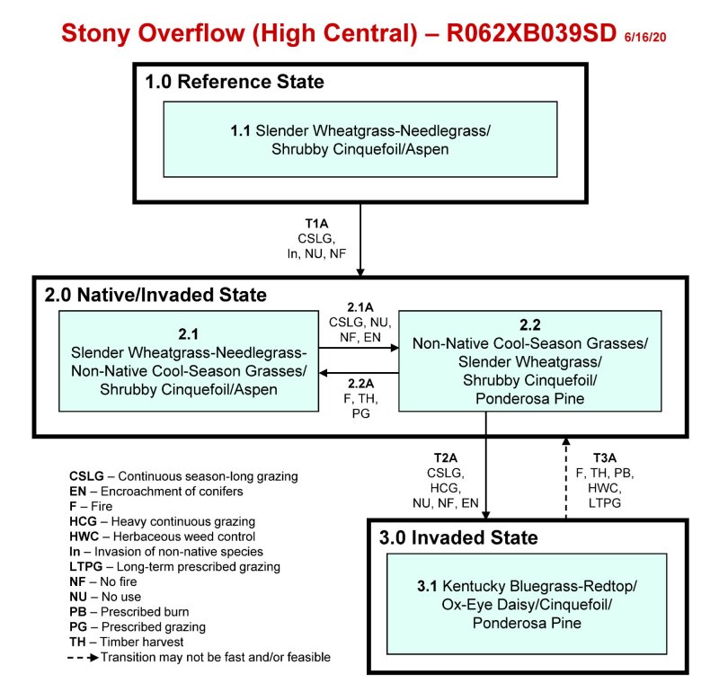
More interactive model formats are also available.
View Interactive Models
Click on state and transition labels to scroll to the respective text
Ecosystem states
State 1 submodel, plant communities
State 3 submodel, plant communities
State 1
Reference State
The Reference State represents what is believed to show the natural range of variability that dominated the dynamics of the Stony Overflow ecological site prior to European settlement. This site in the Reference State (1.0) is dominated by cool-season bunchgrasses, sedges, and a very diverse forb component. Shrubby cinquefoil and snowberry are the dominant shrubs. Trees include quaking aspen, scattered ponderosa pine, and white spruce. Aspen will primary occur along the margin of the Stony Overflow site adjacent to forested slopes. In pre-European times, the primary disturbance mechanisms for this site in the reference condition included grazing and browsing by large ungulates, periods of below and above average precipitation, and periodic fire. Timing of fires and herbivory coupled with weather events dictated the dynamics that occurred within the natural range of variability. Today the primary disturbance is from the lack of fire, concentrated livestock grazing, and wildlife browse. Grasses that are desirable for livestock and wildlife can decline and a corresponding increase in less desirable or more grazing-resistant grasses will occur. Favorable growing conditions occurred during the spring and the warm months of June through August. Today a similar state will be difficult to find due to the predominance and invasiveness of non-native cool-season perennial gasses.
Dominant plant species
-
ponderosa pine (Pinus ponderosa), tree
-
quaking aspen (Populus tremuloides), tree
-
western snowberry (Symphoricarpos occidentalis), shrub
-
shrubby cinquefoil (Dasiphora), shrub
-
slender wheatgrass (Elymus trachycaulus), grass
-
needlegrass (Nassella), grass
-
goldenrod (Oligoneuron), other herbaceous
-
common yarrow (Achillea millefolium), other herbaceous
Community 1.1
Slender Wheatgrass-Needlegrass/Shrubby Cinquefoil/Aspen
Interpretations are based primarily on the Slender Wheatgrass-Needlegrass/Shrubby Cinquefoil Plant Community. This is also considered to be Reference Plant Community (1.1). This community evolved with grazing and browsing by large herbivores, occasional prairie fires, and occasional flooding events. The potential vegetation (composition by weight) is approximately 70 percent grass and grass-like species, 15 percent forbs, 10 percent shrubs, and 5 percent trees. The dominant grasses and grass-likes included slender wheatgrass, bearded wheatgrass, green needlegrass, Columbia needlegrass, Hood’s sedge, and Richardson’s sedge. Common forbs are goldenrod, cinquefoil, western yarrow, and Richardson’s geranium. The dominant shrubs are shrubby cinquefoil and snowberry. There will also be scattered individual ponderosa pine, or white spruce, as well as small to large stands of quaking aspen along the margin of the site adjacent to forested slopes. The tree overstory cover will range between 0 and 10 percent. This plant community is diverse, stable, productive, and is well adapted to the higher elevations of the Black Hills. Community dynamics, nutrient cycling, water cycle, and energy flow are functioning properly. Plant litter is properly distributed with very little movement offsite and natural plant mortality is very low. This is a sustainable plant community in terms of soil stability, watershed function, and biologic integrity.
Figure 7. Annual production by plant type (representative values) or group (midpoint values)
Table 5. Annual production by plant type
| Plant type | Low (lb/acre) |
Representative value (lb/acre) |
High (lb/acre) |
|---|---|---|---|
| Grass/Grasslike | 1945 | 2265 | 2475 |
| Forb | 145 | 300 | 500 |
| Tree | 55 | 255 | 500 |
| Shrub/Vine | 55 | 180 | 325 |
| Total | 2200 | 3000 | 3800 |
Figure 8. Plant community growth curve (percent production by month). SD6201, Black Hills, cool-season dominant. Cool-season dominant.
| Jan | Feb | Mar | Apr | May | Jun | Jul | Aug | Sep | Oct | Nov | Dec |
|---|---|---|---|---|---|---|---|---|---|---|---|
| J | F | M | A | M | J | J | A | S | O | N | D |
| 0 | 0 | 4 | 12 | 25 | 36 | 10 | 5 | 4 | 4 | 0 | 0 |
State 2
Native/Invaded State
The Native/Invaded State represents the more common range of variability that exists with higher levels of grazing management but in the absence of periodic fire due to fire suppression. This state is dominated by cool-season bunchgrasses, sedges, and shrubby cinquefoil. It can be found on areas that are properly managed with grazing and on some areas receiving periodic rest. Native cool-season grasses and sedges will decline as non-native cool-season grasses increase. Non-Native cool-season grasses will make up less than 15 percent of total annual production in this state. Preliminary studies indicate that when Kentucky bluegrass exceeds 30 percent of the plant community and native grasses represent less than 40 percent of the plant community composition, a threshold has been crossed to an Invaded State (3.0). These invaded plant communities that are dominated by Kentucky bluegrass will have significantly less cover and diversity of native grasses and forb species (Toledo, D. et al., 2014).
Dominant plant species
-
ponderosa pine (Pinus ponderosa), tree
-
white spruce (Picea glauca), tree
-
western snowberry (Symphoricarpos occidentalis), shrub
-
shrubby cinquefoil (Dasiphora), shrub
-
slender wheatgrass (Elymus trachycaulus), grass
-
bearded wheatgrass (Elymus caninus), grass
-
goldenrod (Solidago), other herbaceous
-
common yarrow (Achillea millefolium), other herbaceous
Community 2.1
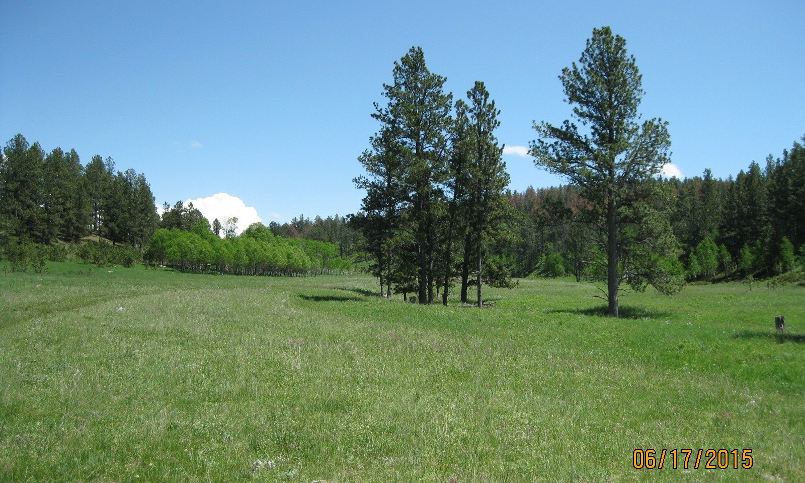
Slender Wheatgrass-Needlegrass-Non-Native Cool-Season Grasses/Shrubby Cinquefoil/Aspen
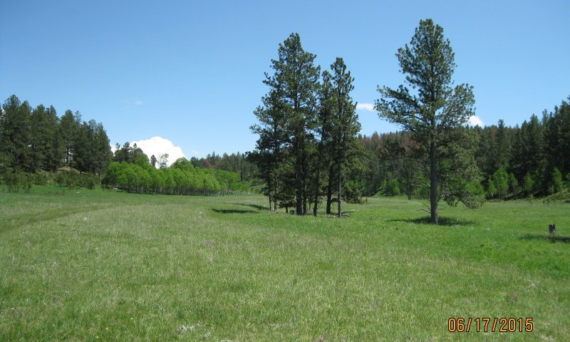
Figure 9. Stony Overflow - High Central, PCP 2.1
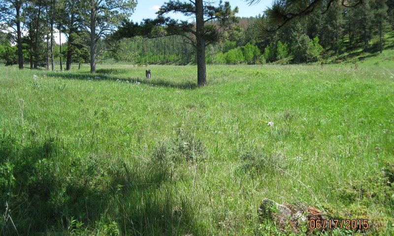
Figure 10. Stony Overflow - High Central, PCP 2.1
This plant community phase is similar to the Reference Plant Community (1.1), but it contains up to 15 percent non-native cool-season grasses (by air-dry weight) such as Kentucky bluegrass, timothy, and redtop. The potential vegetation is approximately 70 percent grass and grass-like species, 15 percent forbs, 10 percent shrubs, and 5 percent trees. The dominant grasses and grass-likes include slender wheatgrass, bearded wheatgrass, green needlegrass, Columbia needlegrass, and non-native cool-season grasses. Common forbs are goldenrod, cinquefoil, western yarrow, and lupine. Canada thistle and bull thistle will likely be present. The dominant shrubs are shrubby cinquefoil and western snowberry. Quaking aspen and conifers will make up the overstory which ranges between 0 and 10 percent cover. Scattered individual ponderosa pine or white spruce (Black Hills spruce) will be scattered across the site. This plant community is resilient and well adapted to the high elevation Black Hills climatic conditions. This is a sustainable plant community in regard to site and soil stability, watershed function, and biologic integrity.
Figure 11. Plant community growth curve (percent production by month). SD6201, Black Hills, cool-season dominant. Cool-season dominant.
| Jan | Feb | Mar | Apr | May | Jun | Jul | Aug | Sep | Oct | Nov | Dec |
|---|---|---|---|---|---|---|---|---|---|---|---|
| J | F | M | A | M | J | J | A | S | O | N | D |
| 0 | 0 | 4 | 12 | 25 | 36 | 10 | 5 | 4 | 4 | 0 | 0 |
Community 2.2
Non-Native Cool-Season Grasses-Slender Wheatgrass/Shrubby Cinquefoil/Ponderosa Pine
This plant community is a result of continuous season-long grazing (grazing at moderate to heavy stocking levels for the full growing season each year without adequate recovery periods following each grazing occurrence), or long-term non-use and no fire, and the expansion of conifers on the site. The potential vegetation is approximately 65 percent grass and grass-like species, 10 percent forbs, 15 percent shrubs, and 10 percent conifer trees. The dominant grasses and grass-likes include non-native cool-season grasses and sedges. Common forbs are goldenrod, cinquefoil, and western yarrow. Canada thistle and bull thistle will likely be present. Dominant shrubs are shrubby cinquefoil and western snowberry. Quaking aspen and ponderosa pine will be the dominant tree species with the overstory ranging between 5 and 15 percent cover. When compared to the Reference Plant Community (1.1) the non-native cool-season grasses have increased, and needlegrass has decreased in composition and production. Forbs diversity is still high, but invasive species are increasing, and conifers have increased.
Figure 12. Plant community growth curve (percent production by month). SD6201, Black Hills, cool-season dominant. Cool-season dominant.
| Jan | Feb | Mar | Apr | May | Jun | Jul | Aug | Sep | Oct | Nov | Dec |
|---|---|---|---|---|---|---|---|---|---|---|---|
| J | F | M | A | M | J | J | A | S | O | N | D |
| 0 | 0 | 4 | 12 | 25 | 36 | 10 | 5 | 4 | 4 | 0 | 0 |
Pathway 2.1A
Community 2.1 to 2.2
Continuous season-long grazing without change in season of use or adequate recovery periods following grazing events; or long-term non-use and no fire and the expansion of conifers on the site will convert the 2.1 Plant Community to the Non-Native Cool-Season Grasses/Slender Wheatgrass/Shrubby Cinquefoil/Ponderosa Pine Plant Community (2.2).
Pathway 2.2A
Community 2.2 to 2.1
Fire or timber harvest to reduce the conifer component followed by prescribed grazing with proper stocking rates, change in season of use, and adequate time for plant recovery will shift the 2.2 Plant Community to the Slender Wheatgrass-Needlegrass-non-Native Cool-Season Grasses/Shrubby Cinquefoil/Ponderosa Pine Plant Community (2.1).
Conservation practices
| Prescribed Burning | |
|---|---|
| Prescribed Grazing | |
| Forest stand improvement pre-treating vegetation and fuels preceding a prescribed fire |
State 3
Invaded State
The Invaded State is the result of invasion and dominance of non-native cool-season grass species on the site. Dominate grasses include Kentucky bluegrass, timothy, and redtop. Continuous season-long grazing or heavy continuous grazing will result in an increase of non-native grasses and forbs. Non-use and no fire will result in an increasing thatch layer that tends to favor the more shade tolerant non-native grass species. The nutrient cycle is impaired, resulting in a higher level of nitrogen which also favors non-native species. Studies indicate that soil biological activity is altered, and this shift apparently exploits the soil microclimate and encourages growth of the non-native grass species. Once the threshold is crossed, a change in grazing management alone cannot cause a reduction in the invasive grass dominance. Preliminary studies indicate this threshold may exist when Kentucky bluegrass exceeds 30 percent of the plant community and native grasses represent less than 40 percent of the plant community composition. Plant communities dominated by Kentucky bluegrass have significantly less cover and diversity of native grasses and forb species (Toledo, D. et al., 2014).
Dominant plant species
-
ponderosa pine (Pinus ponderosa), tree
-
western snowberry (Symphoricarpos occidentalis), shrub
-
shrubby cinquefoil (Dasiphora), shrub
-
Kentucky bluegrass (Poa pratensis), grass
-
redtop (Agrostis gigantea), grass
-
oxeye daisy (Leucanthemum vulgare), other herbaceous
-
sedge (Carex), other herbaceous
Community 3.1
Kentucky Bluegrass-Redtop/Ox-Eye Daisy/Cinquefoil/Ponderosa Pine
This plant community is a result of continuous season-long grazing (grazing at moderate to heavy stocking levels for the full growing season each year, without adequate recovery periods following each grazing occurrence), or heavy continuous grazing (grazing which includes stocking levels well above sustainable carrying capacity for extended portions of the growing season, and at the same time of year each year, without adequate recovery periods following each grazing occurrence); and the expansion of ponderosa pine; or extended periods of non-use and no fire and the expansion of ponderosa pine. This plant community is characterized by a dominance of non-native cool-season grasses that will exceed 30 percent composition and be composed of Kentucky bluegrass, timothy, and redtop. Native sedges and forbs will still be present, but ox-eye daisy, red clover, white clover, Canada thistle, and bull thistle will likely be increasing. Shrubby cinquefoil and western snowberry will likely remain relatively intact. Conifers, primarily ponderosa pine, will increase and aspen will be in decline. When compared to the Reference Plant Community (1.1) the non-native cool-season grasses have increased in composition and production. Forbs are still diverse but non-native and invasive species are increasing, and the canopy cover of ponderosa pine has increased.
Figure 13. Plant community growth curve (percent production by month). SD6201, Black Hills, cool-season dominant. Cool-season dominant.
| Jan | Feb | Mar | Apr | May | Jun | Jul | Aug | Sep | Oct | Nov | Dec |
|---|---|---|---|---|---|---|---|---|---|---|---|
| J | F | M | A | M | J | J | A | S | O | N | D |
| 0 | 0 | 4 | 12 | 25 | 36 | 10 | 5 | 4 | 4 | 0 | 0 |
Transition T1A
State 1 to 2
Continuous season-long grazing; the invasion of non-native cool-season grasses; and extended periods of non-use and no fire will transition the Reference State (1.0) to the Native/Invaded State (2.0).
Transition T2A
State 2 to 3
Continuous season-long grazing; or heavy continuous grazing; and the expansion of conifers will transition the Native/Invaded State (2.0) to the Invaded State (3.0). Long-term non-use and no fire and the expansion of conifers will also cause the Native/Invaded State (2.0) to transition to the Invaded State (3.0). This transition is most likely to originate from plant community 2.2.
Restoration pathway T3A
State 3 to 2
This transition will require fire or timber harvest to remove conifer encroachment and fire or prescribed burning to suppress the non-native cool-season grass, and herbaceous weed control to treat invasive forbs. These practices need to be followed with long-term prescribed grazing including proper stocking rates, change in season of use, and deferment that provides adequate time for plant recovery. This may facilitate a transition from the Invaded State (4.0) to the Native/Invaded State (2.0). This will take a long period of time and recovery may not meet management objectives. Success will largely depend on whether native reproductive propagules remain intact on the site.
Conservation practices
| Brush Management | |
|---|---|
| Prescribed Burning | |
| Prescribed Grazing | |
| Herbaceous Weed Control |
Additional community tables
Table 6. Community 1.1 plant community composition
| Group | Common name | Symbol | Scientific name | Annual production (lb/acre) | Foliar cover (%) | |
|---|---|---|---|---|---|---|
|
Grass/Grasslike
|
||||||
| 1 | Cool-Season Bunchgrass | 1200–1650 | ||||
| green needlegrass | NAVI4 | Nassella viridula | 60–450 | – | ||
| slender wheatgrass | ELTR7 | Elymus trachycaulus | 150–450 | – | ||
| slender wheatgrass | ELTRS | Elymus trachycaulus ssp. subsecundus | 150–300 | – | ||
| Columbia needlegrass | ACNE9 | Achnatherum nelsonii | 30–300 | – | ||
| timber oatgrass | DAIN | Danthonia intermedia | 0–150 | – | ||
| inland bluegrass | PONEI2 | Poa nemoralis ssp. interior | 0–150 | – | ||
| muttongrass | POFE | Poa fendleriana | 60–150 | – | ||
| mountain brome | BRMA4 | Bromus marginatus | 0–150 | – | ||
| poverty oatgrass | DASP2 | Danthonia spicata | 0–150 | – | ||
| prairie Junegrass | KOMA | Koeleria macrantha | 0–150 | – | ||
| Richardson's needlegrass | ACRI8 | Achnatherum richardsonii | 0–150 | – | ||
| Rocky Mountain fescue | FESA | Festuca saximontana | 60–150 | – | ||
| 2 | Tall & Mid- Warm-Season Grasses | 60–300 | ||||
| marsh muhly | MURA | Muhlenbergia racemosa | 60–300 | – | ||
| prairie dropseed | SPHE | Sporobolus heterolepis | 60–150 | – | ||
| 3 | Other Native Grasses | 60–300 | ||||
| water whorlgrass | CAAQ3 | Catabrosa aquatica | 0–150 | – | ||
| downy ryegrass | LEIN6 | Leymus innovatus | 0–150 | – | ||
| western wheatgrass | PASM | Pascopyrum smithii | 30–150 | – | ||
| Grass, perennial | 2GP | Grass, perennial | 30–150 | – | ||
| 4 | Grass-Likes | 150–300 | ||||
| Hood's sedge | CAHO5 | Carex hoodii | 60–150 | – | ||
| Richardson's sedge | CARI | Carex richardsonii | 60–150 | – | ||
| Sprengel's sedge | CASP7 | Carex sprengelii | 30–150 | – | ||
| Grass-like (not a true grass) | 2GL | Grass-like (not a true grass) | 30–150 | – | ||
| clustered field sedge | CAPR5 | Carex praegracilis | 0–60 | – | ||
| 5 | Non-Native Cool-Season Grasses | 0 | ||||
|
Forb
|
||||||
| 6 | Forbs | 150–450 | ||||
| Lewis flax | LILE3 | Linum lewisii | 30–150 | – | ||
| cinquefoil | POTEN | Potentilla | 60–150 | – | ||
| Pacific anemone | ANMU | Anemone multifida | 30–150 | – | ||
| white heath aster | SYER | Symphyotrichum ericoides | 30–150 | – | ||
| littleleaf pussytoes | ANMI3 | Antennaria microphylla | 30–150 | – | ||
| lupine | LUPIN | Lupinus | 60–150 | – | ||
| old man's whiskers | GETR | Geum triflorum | 30–150 | – | ||
| Richardson's geranium | GERI | Geranium richardsonii | 60–150 | – | ||
| stiff goldenrod | OLRI | Oligoneuron rigidum | 60–150 | – | ||
| western yarrow | ACMIO | Achillea millefolium var. occidentalis | 60–150 | – | ||
| Forb, native | 2FN | Forb, native | 30–150 | – | ||
| wild bergamot | MOFI | Monarda fistulosa | 0–60 | – | ||
| mountain deathcamas | ZIEL2 | Zigadenus elegans | 0–60 | – | ||
| Missouri goldenrod | SOMI2 | Solidago missouriensis | 0–60 | – | ||
| prairie bluebells | MELA3 | Mertensia lanceolata | 0–60 | – | ||
| starry false lily of the valley | MAST4 | Maianthemum stellatum | 0–60 | – | ||
| cream pea | LAOC2 | Lathyrus ochroleucus | 0–60 | – | ||
| alpine milkvetch | ASAL7 | Astragalus alpinus | 30–60 | – | ||
| American vetch | VIAM | Vicia americana | 30–60 | – | ||
| bluebell bellflower | CARO2 | Campanula rotundifolia | 0–60 | – | ||
|
Shrub/Vine
|
||||||
| 7 | Shrubs | 60–300 | ||||
| shrubby cinquefoil | DAFRF | Dasiphora fruticosa ssp. floribunda | 60–300 | – | ||
| snowberry | SYMPH | Symphoricarpos | 60–150 | – | ||
| Woods' rose | ROWO | Rosa woodsii | 0–150 | – | ||
| beaked hazelnut | COCO6 | Corylus cornuta | 0–150 | – | ||
| Shrub (>.5m) | 2SHRUB | Shrub (>.5m) | 30–60 | – | ||
| Saskatoon serviceberry | AMAL2 | Amelanchier alnifolia | 0–60 | – | ||
|
Tree
|
||||||
| 8 | Trees | 60–450 | ||||
| quaking aspen | POTR5 | Populus tremuloides | 60–300 | – | ||
| white spruce | PIGL | Picea glauca | 0–60 | – | ||
| ponderosa pine | PIPO | Pinus ponderosa | 30–60 | – | ||
| Tree | 2TREE | Tree | 0–30 | – | ||
Interpretations
Animal community
Wildlife Interpretations
The Black Hills and Bear Lodge Mountains of South Dakota and Wyoming are truly a forested island in a grassland sea. To regional Native Americans they are ‘Paha Sapa”, or “hills that are black”, and from a distance, the ponderosa pine-covered slopes do appear like black hills (Larson, 1999).
The Black Hills and Bear Lodge Mountains are located in the drier areas of a northern mixed-grass prairie ecosystem in which sagebrush steppes to the west yield to grassland steppes to the east. Prior to European settlement, MLRA 62 consisted of diverse grassland, shrubland, and forest habitats interspersed with varying densities of depressional instream wetlands and woody riparian corridors. These habitats provided critical life cycle components for many users. Many species of grassland birds, small mammals, reptiles, amphibians, and herds of roaming bison, elk, and pronghorn were among the inhabitants adapted to this semi-arid region. Roaming herbivores, as well as several species of small mammals and insects, were the primary consumers linking the grassland resources to large predators, such as the gray wolf, mountain lion, grizzly bear, and to smaller carnivores, such as the coyote, bobcat, fox, and raptors.
Beaver inhabited surface waters associated with instream wetlands and woody riparian corridors along streams and drainages. Beaver occupation served as a mechanism to maintain water tables along flood plains and valley floors. During pre-European times, the extent of the wet land sites was likely much more wide-spread and persistent during dry periods, however excessive trapping and removal since that time has changed the hydrology and limited the extent of these sites while drying former mesic areas throughout the MLRA.
Grazing Interpretations
Production and accessibility of plant communities described in the Stony Overflow ecological site can be highly variable; a complete resource inventory is necessary to document plant composition and production. Accurate estimates of carrying capacity should be calculated using vegetative clipping data, animal preference data, and actual stocking records.
Initial suggested stocking rates should be calculated using a base of 912 lb/acre (air-dry weight) per animal-unit-month (AUM). Use a 25 percent harvest efficiency of preferred and desirable forage species (refer to USDA-NRCS National Range and Pasture Handbook). An AUM is defined as the equivalent amount of forage required by a 1,000-pound cow with or without calf, for one month.
Grazing by domestic livestock is one of the major income-producing industries in the area. Rangeland in this area may provide yearlong forage for livestock. During the dormant period, the forage for livestock likely has insufficient protein to meet livestock requirements. Added protein allows ruminants to better utilize the energy stored in grazed plant materials. A forage quality test should be used to determine the level of supplementation needed.
Hydrological functions
This site is dominated by soils in hydrologic group C. Infiltration and runoff potential for this site varies from moderate to low, depending on soil hydrologic group, slope, and ground cover. Refer to the USDA-NRCS National Engineering Handbook, Part 630, for hydrologic soil groups, runoff quantities, and hydrologic curves.
Recreational uses
This site provides opportunities for hunting, hiking, photography, and bird watching. The wide variety of plants that bloom from spring until fall have an aesthetic value that appeals to visitors.
Wood products
Typically, no appreciable wood products are present on this site.
Other products
Harvesting the seeds of native plants can provide additional income on this site.
Other information
Revision Notes: Provisional
This provisional ecological site description (ESD) has passed quality control (QC) and quality assurance (QA) to ensure that it meets the 2014 NESH standards for a provisional ecological site description. This site should not be considered an Approved ESD, as it is only the foundational site concepts and requires further data collection, site investigations, and final State-and-Transition Model (STM) reviews before it can be used as an Approved ESD meeting NESH standards.
Site Development and Testing Plan
Future work, as described in an official project plan, is necessary to validate the information in this provisional ecological site description. The plan will include field activities for low-, medium-, and high-intensity sampling, soil correlations, and analysis of the data. Annual field reviews should be done by soil scientists and vegetation specialists. Final field review, peer review, quality control, and quality assurance reviews are required to produce the final document.
Supporting information
Inventory data references
Information presented here has been derived from NRCS clipping data and other inventory data. Field observations from range-trained personnel were also used. Those involved in developing this site include: Stan Boltz, range management specialist (RMS), NRCS; Dan Brady, soil scientist (SS), NRCS; Mitch Faulkner, RMS, NRCS; Rick Peterson, (RMS), NRCS; and Jim Westerman, (SS), NRCS. All inventory information and data records are compiled within the Rapid City, SD USDA-NRCS Shared “S” network drive.
Other references
Brown, P. M. and C. Hull-Sieg. 1996. Fire History in Interior Ponderosa Pine Communities of the Black Hills, South Dakota, USA, Int. J. Wildland Fire 6(3): 97-105.
Cleland, D.T., J.A. Freeouf, J.E. Keys, G.J. Nowacki, C.A. Carpenter, and W.H McNab. 2007. Ecological subregions: Sections and subsections of the conterminous United States. USDA Forest Service, General Technical Report WO-76D. https://www.fs.fed.us/research/publications/misc/73326-wo-gtr-76d-cleland2007.pdf (accessed 31 January 2019).
Cowardin, L.M., V. Carter, F.C. Golet, and E.T. LaRoe. 1979. Classification of wetlands and deep-water habitats of the United States. U.S. Fish and Wildlife Service FWS/OBS-79/31.
U.S. Environmental Protection Agency. 2018. EPA level III and level IV ecoregions of the conterminous United States. https://www.epa.gov/eco-research/level-iii-and-iv-ecoregions- conterminous-united-states (accessed 26 April 2018).
Froiland Sven G. and Ronald R. Weedon. 1990. Natural History of the Black Hills and Badlands. Center for Western Studies, Augustana College, Sioux Falls SD.
Gartner F. R. and W. W. Thompson. 1972. Fire in the Black Hills forest-grass ecotone, South Dakota Agricultural Experiment Station, Journal Series No 1115.
Hall, J. S.; Marriott, J. H.; Perot, J. K. 2002. Ecological Conservation in the Black Hills. Minneapolis, MN: The Nature Conservancy.
High Plains Regional Climate Center, University of Nebraska. 2018. http://www.hprcc.unl.edu/ (accessed 6 April 2018).
Hoffman, George R., Alexander, Robert R. 1987. Forest Vegetation of the Black Hills National Forest of South Dakota and Wyoming: a habitat type classification. Res. Pap. RM-276. USDA-USFS, Rocky Mountain Forest and Range Experiment Station.
Larson, Gary E. and James R. Johnson. 1999. Plants of the Black Hills and Bear Lodge Mountains. South Dakota State University, College of Agriculture and Biological Sciences and Agriculture Experiment Station, Bulletin 732, Brookings, SD.
McIntosh, A. C. 1949. A botanical survey of the Black Hills of South Dakota. Black Hills Engineer. 28 (4): 3-75.
Parrish, J. B., D. J. Herman, D. J. Reyher, and F. R. Gartner. 1996. A Century of Change in the Black Hills and Riparian Ecosystems. Open Prairie: Bulletins 726, Agriculture Experiment Station, South Dakota State University. https://openprairie.sdstate.edu/agexperimentsta_bulletins/726
Shepperd, W. D. and M. A. Battaglia. 2002. Ecology, silviculture, and management of Black Hills ponderosa pine. Gen. Tech. Rep. RMRS-GTR-97. Fort Collins, CO: US Department of Agriculture, Forest Service, Rocky Mountain Research Station. 112 p.
Toledo, D., M. Sanderson, K. Spaeth, J. Hendrickson, and J. Printz. 2014. Extent of Kentucky bluegrass and its effect on native plant species diversity and ecosystem services in the Northern Great Plains of the United States. Invasive Plant Science and Management. 7(4):543–522. Weed Science Society of America.
U.S. Department of Agriculture, U.S. Forest Service. 2017. Black Hills Resilient Landscape Project, Draft Environmental Impact Statement.
U.S. Department of Agriculture, Natural Resources Conservation Service. 2019. Electronic field office technical guide. https://efotg.sc.egov.usda.gov (accessed 11 June 2020).
Soil Survey Staff. 2019. Official soil series descriptions. USDA Natural Resources Conservation Service. https://www.nrcs.usda.gov/wps/portal/nrcs/detail/soils/home/?cid=nrcs142p2_053587 (accessed 16 June 2020).
Soil Survey Staff. 2019. Web Soil Survey. USDA Natural Resources Conservation Service. https://websoilsurvey.sc.egov.usda.gov/App/WebSoilSurvey.aspx (accessed 11 June 2020).
U.S. Department of Agriculture, Natural Resources Conservation Service. 2006. Land resource regions and major land resource areas of the United States, the Caribbean, and the Pacific Basin. Agriculture Handbook 296. https://www.nrcs.usda.gov/Internet/FSE_DOCUMENTS/nrcs142p2_050898.pdf (accessed 27 January 2018).
U.S. Department of Agriculture, Natural Resources Conservation Service. 2014. National ecological site handbook, 1st ed. https://www.nrcs.usda.gov/wps/portal/nrcs/detail/soils/ref/?cid=nrcseprd1291232 (accessed 27 January 2018).
U.S. Department of Agriculture, Natural Resources Conservation Service. 2012. National engineering handbook, part 630. Hydrology chapters from e-Directives. https://directives.sc.egov.usda.gov/viewerFS.aspx?hid=21422 (accessed 16 June 2020).
U.S. Department of Agriculture, Natural Resources Conservation Service. 2018. Climate data. National Water and Climate Center. http://www.wcc.nrcs.usda.gov/ (accessed 2 December 2018).
U.S. Department of Agriculture, Natural Resources Conservation Service. 1997. National range and pasture handbook, rev. 1, 2003. https://www.nrcs.usda.gov/Internet/FSE_DOCUMENTS/stelprdb1043055.pdf (accessed 7 January 2018).
U.S. Department of Agriculture, Natural Resources Conservation Service. 2019. National Soil Information System, Information Technology Center. http://nasis.nrcs.usda.gov (accessed 30 July 2019).
U.S. Department of Agriculture, Natural Resources Conservation Service. 2019. PLANTS database. National Plant Data Team, Greensboro, NC. http://plants.usda.gov (accessed 16 June 2020).
U.S. Department of Agriculture, Natural Resources Conservation Service. 2007. National engineering handbook, part 654. Rosgen Stream Classification Technique – Supplemental Materials, Technical Supplement 3E. https://directives.sc.egov.usda.gov/OpenNonWebContent.aspx?content=17833.wba
(accessed 16 June 2020).
Wrage, K. J. 1994. The effects of ponderosa pine on soil moisture, precipitation, and understory vegetation in the Black Hills of South Dakota. 158 p. Thesis.
Contributors
Rick L. Peterson
Mitch D. Faulkner
Stan C. Boltz
Approval
Suzanne Mayne-Kinney, 2/06/2025
Acknowledgments
This ecological site description developed by Rick L. Peterson on June 17, 2020.
Nondiscrimination Statement
In accordance with Federal civil rights law and U.S. Department of Agriculture (USDA) civil rights regulations and policies, the USDA, its Agencies, offices, and employees, and institutions participating in or administering USDA programs are prohibited from discriminating based on race, color, national origin, religion, sex, gender identity (including gender expression), sexual orientation, disability, age, marital status, family/parental status, income derived from a public assistance program, political beliefs, or reprisal or retaliation for prior civil rights activity, in any program or activity conducted or funded by USDA (not all bases apply to all programs). Remedies and complaint filing deadlines vary by program or incident.
Persons with disabilities who require alternative means of communication for program information (e.g., Braille, large print, audiotape, American Sign Language, etc.) should contact the responsible Agency or USDA's TARGET Center at (202) 720-2600 (voice and TTY) or contact USDA through the Federal Relay Service at (800) 877-8339. Additionally, program information may be made available in languages other than English.
To file a program discrimination complaint, complete the USDA Program Discrimination Complaint Form, AD-3027, available online at https://www.ascr.usda.gov/filing-program-discrimination-complaint-usda-customer and at any USDA office, or write a letter addressed to USDA and provide in the letter all of the information requested in the form. To request a copy of the complaint form, call (866) 632-9992. Submit your completed form or letter to USDA by:
(1) mail: U.S. Department of Agriculture, Office of the Assistant Secretary for Civil Rights, 1400 Independence Avenue, SW, Washington, D.C. 20250-9410;
(2) fax: (202) 690-7442; or
(3) email: program.intake@usda.gov.
USDA is an equal opportunity provider, employer, and lender.
Rangeland health reference sheet
Interpreting Indicators of Rangeland Health is a qualitative assessment protocol used to determine ecosystem condition based on benchmark characteristics described in the Reference Sheet. A suite of 17 (or more) indicators are typically considered in an assessment. The ecological site(s) representative of an assessment location must be known prior to applying the protocol and must be verified based on soils and climate. Current plant community cannot be used to identify the ecological site.
| Author(s)/participant(s) | |
|---|---|
| Contact for lead author | |
| Date | 02/06/2025 |
| Approved by | Suzanne Mayne-Kinney |
| Approval date | |
| Composition (Indicators 10 and 12) based on | Annual Production |
Indicators
-
Number and extent of rills:
-
Presence of water flow patterns:
-
Number and height of erosional pedestals or terracettes:
-
Bare ground from Ecological Site Description or other studies (rock, litter, lichen, moss, plant canopy are not bare ground):
-
Number of gullies and erosion associated with gullies:
-
Extent of wind scoured, blowouts and/or depositional areas:
-
Amount of litter movement (describe size and distance expected to travel):
-
Soil surface (top few mm) resistance to erosion (stability values are averages - most sites will show a range of values):
-
Soil surface structure and SOM content (include type of structure and A-horizon color and thickness):
-
Effect of community phase composition (relative proportion of different functional groups) and spatial distribution on infiltration and runoff:
-
Presence and thickness of compaction layer (usually none; describe soil profile features which may be mistaken for compaction on this site):
-
Functional/Structural Groups (list in order of descending dominance by above-ground annual-production or live foliar cover using symbols: >>, >, = to indicate much greater than, greater than, and equal to):
Dominant:
Sub-dominant:
Other:
Additional:
-
Amount of plant mortality and decadence (include which functional groups are expected to show mortality or decadence):
-
Average percent litter cover (%) and depth ( in):
-
Expected annual annual-production (this is TOTAL above-ground annual-production, not just forage annual-production):
-
Potential invasive (including noxious) species (native and non-native). List species which BOTH characterize degraded states and have the potential to become a dominant or co-dominant species on the ecological site if their future establishment and growth is not actively controlled by management interventions. Species that become dominant for only one to several years (e.g., short-term response to drought or wildfire) are not invasive plants. Note that unlike other indicators, we are describing what is NOT expected in the reference state for the ecological site:
-
Perennial plant reproductive capability:
Print Options
Sections
Font
Other
The Ecosystem Dynamics Interpretive Tool is an information system framework developed by the USDA-ARS Jornada Experimental Range, USDA Natural Resources Conservation Service, and New Mexico State University.
Click on box and path labels to scroll to the respective text.