Ecological dynamics
Plant tables have not been developed for this site. Until such time as they can be updated, use the plant tables in the referenced literature that correlates to this concept (refer to plant tables below in this section for related legacy sites). With respect to the imperfect alignment of such correlations, be aware of these shortcomings in their applicability to conservation planning.
Early work by (Kuchler, 1964) identified the potential natural vegetation type for the Canadian Plateaus LRU as that of the grama/buffalograss short grass prairie. The Ephemeral Drainageways ecological site is dominated by short grasses, but also contains a mix of shrubs, forbs, and succulents. As is typical of plant communities, annual variability in precipitation translates to considerable short-term fluctuations in annual production within a given plant community phase.
Within this site, the dominant species of short grasses are inherently drought- and grazing-tolerant (Lauenroth, 1994). Across the western parts of the U.S., blue grama is one of the most extensively distributed grasses and occurs in a wide variety of different ecosites ranging from grasslands to shrubland and woodland sites. This grass evolved with grazing by large herbivores and, when grazed continuously, tends to form a short sod. When allowed to grow under lower grazing pressures, the plants develop the upright physiognomy of a bunchgrass. If blue grama is eliminated from an area by extended drought (3 to 4 years) or disturbance such as plowing, regeneration is slow because of very slow tillering rates (Samuel, 1985), low and variable seed production, minimal seed storage in the soil (Coffin, 1989) and limited seedling germination and establishment due to particular temperature and extended soil moisture requirements for successful seedling establishment (Briske, 1978). Buffalograss, which is more abundant at warmer, lower elevations of this site, is often found occupying swale positions, such as drainageway bottoms, across the landscape. Buffalograss is less drought-tolerant than blue grama but re-establishes more quickly following disturbance due to higher seed abundance and viability and more effective above-ground tillering (Peters, 2008).
There are numerous variables such as elevation, latitude, hydrology, soil depth, fire frequency, grazing dynamics, and anthropogenic effects that influence plant communities. As the plateaus gently climb to the west, elevation increases along with its orographic moisture. To the east, proximity to greater warm-season moisture from the Gulf of Mexico increases. As elevation approaches its upper extreme (about 7,500 feet) near the foot of the Rocky Mountains, cool-season plants become most abundant. Therefore, blue grama and broom snakeweed are more common in the east; while western wheatgrass, bottlebrush squirreltail, fringed sage, and common sagewort increase their presence to the west. Where the surrounding plateaus are dominated by shale, surface textures of clay loam are common, and salts may accumulate in the profile; here, alkali sacaton and four-wing saltbush increase within drainageway sites. Another variable in this site is the relative stage of “wetness”, or moisture harvested from upland positions. In places where greater run-on occurs, such as in steeper and larger valley watersheds, expect to see some carex and juncus and, where higher salinity occurs, possibly inland saltgrass.
Large-scale processes such as climate, fire and grazing influence this site. During years with favorable growing seasons, the effects of grazing may be mitigated. During years of low precipitation, grazing can magnify degradation of the site (Milchunas, 1989). Fire is a natural disturbance regime that suppresses succulents and shrubs while stimulating grasses and forbs, however, in contrast to midgrass and tall-grass prairie sites, fire is less important (Wright, 1982). This is because the drier conditions produce less vegetation/fuel load, lowering the relative fire frequency. However, historically, fires that did occur were often very expansive, especially after a series of years where above average precipitation built enough litter/fine fuels. Currently, fire suppression and more extensive grazing in the region have decreased the fire frequency, and it is unlikely that these processes could occur at a natural scale (USNVC, 2017)-G144. According to (Gebow, 2001), fire effects in the same location will vary, especially with fire timing, where seasonality can either hinder or benefit plants depending on their growing stage. Precipitation events occurring before and after fire will also influence the recovery of plants. Fire promotes rhizomatous plant species, such as western wheatgrass, that can take advantage of below-ground rhizomes from which tillering is rapidly initiated. Due to higher vegetative production potentials within the drainageway site, fuel loads sufficient to carry an effective fire may be attained in shorter periods of grazing deferment relative to adjacent, upland sites.
Correlation to Current Ecological Sites:
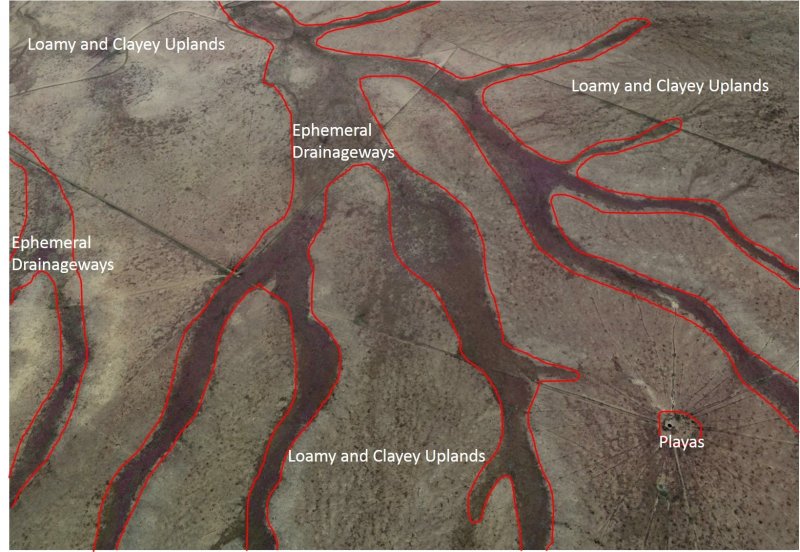
Swale- R070AY006NM: This site was written for a broad range of soil types that include low lying drainageways, playas and other depressions. Though close in concept, the Ephemeral Drainageway site specifically separates this type of ecology from that of a playa, which has ponding rather than flooding, accumulates more salts, and therefore has unique plant and wildlife interpretations.
From Swale (R070AY006NM) Tables:
Annual production by plant type
Plant Type Low (Lb/Acre) Representative Value (Lb/Acre) High (Lb/Acre)
Grass/Grasslike---------935----------------------1530---------------------------------2125
Forb-----------------------110----------------------180----------------------------------250
Shrub/Vine--------------55------------------------90------------------------------------125
Total----------------------1100---------------------1800----------------------------------2500
Community 1.1 plant community composition
Common Name----------Symbol----------Scientific Name----------Annual Production (Lb/Acre)
GRASS/GRASSLIKE
1 western wheatgrass------PASM-----------Pascopyrum smithii--------------360–450
2 blue grama-----------------BOGR2----------Bouteloua gracilis----------------360–450
3 vine mesquite-------------PAOB-----------Panicum obtusum----------------360–450
4 James' galleta--------------PLJA------------Pleuraphis jamesii----------------90–270
5 alkali sacaton---------------SPAI------------Sporobolus airoides--------------90–270
6 sideoats grama-------------BOCU----------Bouteloua curtipendula----------90–270
8 saltgrass---------------------DISP------------Distichlis spicata-------------------18–54
9 mat muhly-------------------MURI----------Muhlenbergia richardsonis-------18–54
10 threeawn-------------------ARIST----------Aristida------------------------------18–54
11 squirreltail------------------ELEL5----------Elymus elymoides-----------------36–90
12 creeping muhly-------------MURE---------Muhlenbergia repens--------------0–36
FORB
13 upright prairie coneflower-RACO3-------Ratibida columnifera-------------18–90
14 Cuman ragweed-------------AMPS---------Ambrosia psilostachya------------18–90
15 New Mexico thistle---------CINE----------Cirsium neomexicanum----------18–90
16 prairie clover-----------------DALEA-------Dalea---------------------------------18–90
17 Forb, annual------------------2FA-----------Forb, annual------------------------36–90
18 Forb, perennial---------------2FP-----------Forb, perennial--------------------36–90
SHRUB/VINE
19 fourwing saltbush-------------ATCA2-------Atriplex canescens----------------0–90
20 broom snakeweed------------GUSA2--------Gutierrezia sarothrae------------0–54
21 ragweed sagebrush-----------ARFR3---------Artemisia franserioides---------0–54
22 winterfat-----------------------KRLA2----------Krascheninnikovia lanata-------0–54
Clayey Upland- R070AY002NM: This site was developed for a broad range of soils that occur on upland fans, plains, hillslopes, and some depressions. The Ephemeral Drainageways site is specifically intended to target the plant communities that occur in run-on sites that are not depressions. Though upland sites may have been correlated to soil components mapped in drainageways in the past, they are specifically ignored here due to their improper conceptual application.
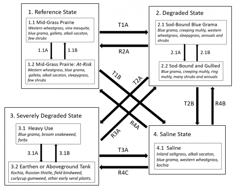
State 1
Reference State
Grasses are the primary plant species in the reference state. The main species are western wheatgrass, blue grama, vine mesquite, galleta, alkali sacaton, ring muhly and creeping muhly. The typical shrubs likely encountered in this state include fourwing saltbush, fringed sage, and broom snakeweed.
A temperature gradient across the LRU also plays a role in the presence or abundance of some species, and is generally seen as an eastward trend of lowering elevation with rising average annual temperatures. In the easternmost part of this LRU, a greater presence of warm-season plants such as buffalograss is expected. Western parts of this LRU will have a higher prevalence of cool-season grasses such as western wheatgrass and bottlebrush squirreltail as well as fringed sage.
Community 1.1
1.1 Mid-Grass Prairie Grassland with Occasional Shrubs
This phase of the reference state has nearly 100 percent canopy cover and consists of mostly grasses with 5 to 15 percent shrubs and 5 to 20 percent forbs. Annual production averages around 1,800 to 2,500 pounds per acre and can range from 1,000 pounds per acre in poor years to over 3,500 pounds per acre in favorable years.
Community 1.2
1.2 Mid-Grass Prairie: At Risk
This phase of the reference state has nearly 100 percent canopy cover and consists of mostly grasses with 10 to 25 percent shrubs and 10 to 30 percent forbs, and succulents. In addition, some species are expected to be reduced or missing from this site due to grazing pressure by stock or wildlife. These decreasers include vine mesquite, sideoats grama, western wheatgrass and fourwing saltbush.
Pathway P1.1A
Community 1.1 to 1.2
This pathway represents period of time following fires or drought where the ecosystem is relying on the seed bank to reestablish the plant community. Some erosion could occur, delaying the process, but plentiful nutrient availability awaits some moisture to jumpstart plant growth. In the meantime, annuals might find the opportunity to gain some ground. The process can be also by some frequent grazing activity, either wildlife and/or livestock. Grazing reduces fuels which decreases fire return intervals, and allows shrubs to gain an advantage.
Pathway P1.2A
Community 1.2 to 1.1
This pathway represents a longer period since drought or fire, with maybe a favorable precipitation year or two in the recent past. Though opportunistic annuals may have taken advantage of the open area following the disturbance, they are soon outcompeted by grasses as they revegetate, increasing in coverage over a few successive years. The pathway could also represent a rest period or significant decrease in grazing pressure in both frequency and intensity, or deferred grazing management planning.
State 2
Degraded State
This site has been grazed continuously for several years, if not decades or longer. Annuals and shrub species have increased in coverage, while several grass species including vine mesquite, western wheatgrass, sideoats grama and the shrub fourwing saltbush have decreased or are no longer present. Blue grama, buffalograss, mat (creeping) muhly, ring muhly and sleepygrass will dominate the grass species while shrubs and succulents such as plains pricklypear, stick cholla, broom snakeweed, fringed sage, and rubber rabbitbrush will increase. In warmer, easterly parts of this site’s range, cholla, buffalograss, and silver bluestem are more likely to increase whereas, in the west, plains pricklypear, ring muhly and fringed sage will be more prominent.
As shrubs and forbs increase, they gain a competitive advantage, primarily by out-competing the grass for water and nutrients, especially during periods of short- and long-duration drought. Fire had been the natural event in the Great Plains that thwarts shrub species from gaining a competitive advantage and facilitates greater colonization by grasses. Historic continuous grazing has prevented the fuel loads in these grasslands from being able to carry a fire, therefore giving shrubs and annuals their advantage.
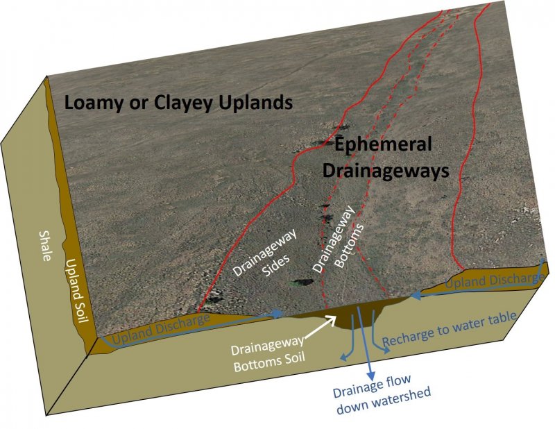
As shrubs increase, root density and turnover in the soil begins to lessen causing a decrease in decomposition rates which are a source of nutrient supply to plants. In return, storage of labile and sequestered carbon pools decline causing a decrease in soil organic matter. Soil organic matter decline coincides with lower infiltration capacity, water holding capacity, and higher bulk density, all which lead to decreased resiliency to drought and heat stress. It also increases erosion rates and may lead to gully formation.
Community 2.1
Sod-bound blue grama
Sites are significantly covered by blue grama and/or creeping muhly. Foliar coverage remains high, from 75 to 100 percent with 0 to 15 percent bare ground, and annuals and shrubs composing a minimum of 10 percent of this canopy and ranging up to 40 percent.
Community 2.2
Sod-bound and gullied
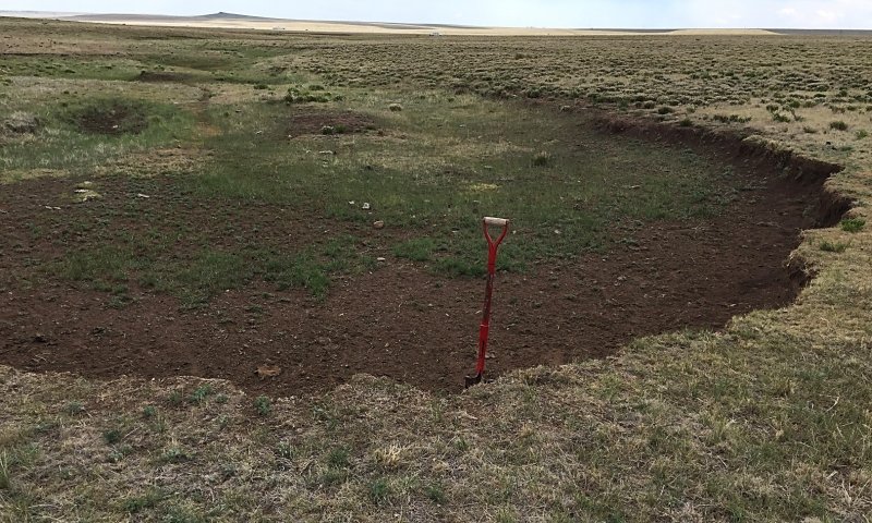
Figure 5. Area below cut represents phase 3.1. Area above cut represents phase 2.2.
These sites are hydrologically impaired due to entrenchment of the drainage bottom via gully erosion. This site is especially vulnerable to gully erosion due to its concave position in the landscape subject to concentrated flow from runoff during heavy rain events. Gully formation tends to self-perpetuate as it provides a weakness as a topographic nickpoint in otherwise unreinforced and highly erodible materials. Gullies act to provide unwanted drainage to formerly wetter parts of the landscape, causing a loss in acreage of this limited but important ecological corridor of highly productive land. This process renders most of the acreage of the former bottomland as drier upland, and expect to see a plant community that resembles more upland ecosites. The new “true” bottom is now the gully floor which may or may not be vegetated, based on how recent it was scoured. In some locations, this new bottom is well established and vegetated, and may have access to the water table and therefore hydric. In these situations, some rushes or sedges might be present.
Foliar cover ranges from 75 to 95 percent on the remnant bottoms (now terraced or elevated and well drained) with 0 to 15 percent bare ground and annuals and shrubs ranging from 10 to 50 percent cover. The new bottom, or gully floor, can vary in plant cover from 0 to 100 percent.
Pathway P2.1A
Community 2.1 to 2.2
This pathway represents an increase in grazing intensity coupled with periods of drought. Specifically, year-round grazing, without significant periods of rest can cause a loss in species diversity, which can result in several negative feedback dynamics. These are primarily expressed as a function of increased compaction, which destroys soil surface structure and decreases infiltration, and expansion of bare-ground patches. Together, these processes cause the ground to become susceptible to first: rain splash effects, or loosening of soil surface particles from their former structure units, and second: along with decreased infiltration, the tendency for surface overland flow to initiate. As the flow increases, the detached particles are suspended and transported, increasing the cutting power of the water and causing erosion to accelerate. At some threshold, the cutting power will have the ability to start a gully headcut.
Pathway P2.2A
Community 2.2 to 2.1
This pathway represents an implementation of deferred grazing or rested periods so that species diversity and density can recover. In situations where the gully formation is minor, natural rates of sedimentation may cause the channel to fill on its own naturally as long as the area stays well vegetated. In cases where the gully is deeper, and not fully vegetated, some channel restoration techniques may need to be employed. Several types of grade-control structures that use the local processes and resources of sediment redistribution can be used to help fill and stabilize these eroded areas (Zeedyke, 2009).
State 3
Severely Degraded State
The degradation in this state is severe, with significant damage to the soil profile that alters its ability to produce a viable plant community for wildlife or agricultural uses on its own. The grass component is dominated by sod-bound blue grama and/or creeping muhly with minor amounts of western wheatgrass, bottlebrush squirreltail, and buffalograss. This condition usually results in a compromised soil surface that is highly susceptible to gully erosion.
Community 3.1
Heavy Use
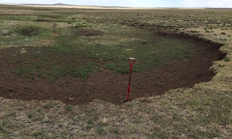
Figure 6. Area below cut represents phase 3.1. Area above cut represents phase 2.2.
This phase of the Severely Degraded state can be brought upon through a variety of different mechanisms: plowing for dryland cropping; stock trails leading to resource; two-track road; proximity to high runoff area. These impacts can result in a loss in the anchoring of topsoil by plants, exposing the surface to erosive runoff events. Severe gullying results in reshaping of the drainageway landform characterized by a change in the local hydrology. The result is a decrease in water infiltration and storage as well as its residence time on the landscape.
It is common for annuals and shrubs to compose greater than 50 percent of foliar cover with bare ground composing 30 to 60 percent of the site. The remnant portion of the drainageway bottoms will now resemble plant community compositions of nearby uplands, but usually retains the denser canopy associated with run-on sites. The new drainageway bottom is the gully floor which may contain anywhere from 0 to 100 percent canopy cover ranging from sedges and rushes to kochia.
Community 3.2
Earthen or aboveground tank
Typically, the land has been converted to alternative uses to grazing such as for watering or corralling livestock, or other industrious purposes. These areas are often limited in their extent with a radius of 50 to 100 meters of the activity but have an impact at a greater radius. Adjacent areas, both up and downstream from these heaviest impacted locations, can have conditions characterized by the Sod-Bound and Gullied phase (2.2) but can also be in a Heavy Use phase (3.1). Severity is determined by connectedness and proximity due to the heightened runoff or head-cutting from the compacted and bare ground.
Pathway P3.1A
Community 3.1 to 3.2
Installation of a fixed location stock tank that draws animals regularly to the same location. Their repetitive, and continual traffic causes severe trampling, compaction, and denuding of the vegetation and soil surface. The compacted soil does not allow water or roots to penetrate, causing runoff to accelerate to surrounding areas and maintaining the bare ground status. In summer months, the bare ground can cause heat to build in the thermal mass of the soil surface which can accelerate drying of the soil, expose it to wind erosion, which can then be an air pollution hazard.
Pathway P3.2A
Community 3.2 to 3.1
Typically, the land has been converted to alternative uses to grazing such as for watering or corralling livestock, or other industrious purposes. These areas are often limited in their extent with a radius of 50 to 100 meters of the activity but have an impact at a greater radius. Adjacent areas, both upstream and downstream from these heaviest impacted locations, can have conditions characterized by the Sod-Bound and Gullied phase (2.2) but can also be in a Heavy Use phase (3.1). Severity is determined by connectedness and proximity due to the heightened runoff or head-cutting from the compacted and bare ground.
State 4
Saline State
This state occurs where significant salts (particularly gypsum) have accumulated in soils as a result of the net upward movement of water into a given Playa (see Water Features above). Given enough data, this state could probably be divided into multiple phases, as plant communities and channel morphology vary widely in response to grazing regime, hydrology, and construction activities.
Community 4.1
Saline
Soils in this phase range from very slightly saline to slightly saline (EC of 2-8 dS/m), and contain significant amounts of gypsum concentrations (often nests of crystals). The plant community contains a preponderance of salt-tolerant species such as inland saltgrass, alkali sacaton, and kochia. Blue grama and western wheatgrass are often abundant, as well. Production and community composition vary widely within this phase, depending on recent grazing regime and weather patterns. Total annual production ranges from 1,000 to 2,200 pounds per acre. Alkali sacaton and western wheatgrass generally decrease under continuous grazing.
Transition T1A
State 1 to 2
Grazing pressure, or severe flooding events, coupled with or following a single drought event, can cause a state shift to the degraded condition.
Transition T1B
State 1 to 4
Landscape hydrology is altered such that the drainageway becomes a site of elevated groundwater discharge. This is most often the result of the addition of irrigation water to landforms above the stretch of drainageway in question, but could theoretically occur in response to changes in weather patterns. Slow variables: In periods between flooding events, capillary action draws groundwater to the surface of the soil. Evapotranspiration leaves behind the salts (particularly gypsum) that were dissolved in the groundwater. Since the water table is elevated, flooding no longer flushes these salts from soils. Thus, over a number of years under the new hydrologic regime, significant amounts of salts accumulate in the drainageway soils.
Restoration pathway R2A
State 2 to 1
Where the condition of the range is degraded without significant formation of gullies, a simple changing of management strategies may lead to restoration. This involves relying on techniques that value plant production and diversity over herd size, using systems such as deferred grazing with periods of rest, especially during drought periods. Use of burning strategies, following a period that allows fuels to accumulate, may be necessary to allow grasses to re-dominate. Some reseeding or shrub removal measures may need to accompany this management shift. Where gully formation is present and significant, more intensive restoration techniques need to be employed. The installation of small rock grade control structures, or other engineered methods (Zeedyke, 2009), along with brush control and, depending on viability of seedbank, reseeding.
Burning can be a useful tactic to control shrubs and possibly exotic species. Since the production is generally higher in this site compared to surrounding uplands, a shorter period of grazing rest, relative to adjacent upland sites, may be sufficient to build the fuel load required to carry a fire hot enough to kill snakeweed and cholla.
Transition T2A
State 2 to 3
Installation of a watering facility, either in ground or above ground, magnifies the trampling traffic in the area. Corrals or other high use structures can have the same effect. These areas typically have a preponderance of bare ground, with only small patches of grass and annuals. They now act as a source for concentrated overland flow and this will impact areas downstream by applying great erosive cutting power to the bottomland, usually to the effect of significant gully formation.
Transition T2B
State 2 to 4
Landscape hydrology is altered such that the drainageway becomes a site of elevated groundwater discharge. This is most often the result of the addition of irrigation water to landforms above the stretch of drainageway in question, but could theoretically occur in response to changes in weather patterns. Slow variables: In periods between flooding events, capillary action draws groundwater to the surface of the soil. Evapotranspiration leaves behind the salts (particularly gypsum) that were dissolved in the groundwater. Since the water table is elevated, flooding no longer flushes these salts from soils. Thus, over a number of years under the new hydrologic regime, significant amounts of salts accumulate in the drainageway soils.
Restoration pathway R3A
State 3 to 2
The goal here is to increase the residence time of water on the landscape following a precipitation event. The focus should be on areas where water is concentrating, and methods that will work to spread the runoff over the largest extent of bottomland as possible. Success will be determined by whether the areas can be simultaneously revegetated, and all before the next significant erosive event. It would also be wise to guarantee appropriate amounts of moisture are available to ensure success of plant establishment under any possible weather condition.
Intensive remediation of the site via landform restoration techniques will be required following the removal of tanks, filling in of pits, or reclaiming gullies. It might be strategic to first address compaction of surrounding upland areas by encouraging annuals that deploy penetrating taproots. Eventually the site can be seeded with a more native blend of grasses and forbs. In cases of severe compaction, where plants cannot establish on their own, an initial deep plowing may be required to break up the dense surface. Other methods such as adding amendments like mulch or gravel may be required to help restore infiltration and root penetrability. Following this, gullies can be treated using methods to encourage sediment aggradation in smaller incremental steps. Additional sediment retention steps can be added sequentially over time to elevate the grade of the gullies to a level even with the historic bottomland. Many techniques and methods exist to handle a variety of restoration situations (Zeedyke, 2009).
Transition T3A
State 3 to 4
Landscape hydrology is altered such that the drainageway becomes a site of elevated groundwater discharge. This is most often the result of the addition of irrigation water to landforms above the stretch of drainageway in question, but could theoretically occur in response to changes in weather patterns. Slow variables: In periods between flooding events, capillary action draws groundwater to the surface of the soil. Evapotranspiration leaves behind the salts (particularly gypsum) that were dissolved in the groundwater. Since the water table is elevated, flooding no longer flushes these salts from soils. Thus, over a number of years under the new hydrologic regime, significant amounts of salts accumulate in the drainageway soils.
Restoration pathway R4A
State 4 to 1
R4A, R4B, R4C: Each restoration pathway from State 4 will necessarily involve a change in landscape hydrology which effectively lowers the water table below the stretch of drainageway in question. In most cases, this will involve a reduction or cessation of irrigation activities higher in the watershed. The result is that water effectively percolates through the soils of the floodplains and drainageway bottoms. Highly soluble salts such as sodium chloride and sodium bicarbonate are removed rapidly—perhaps in a matter of years. Gypsum, having only moderate solubility and often being quite concentrated in State 4, will require decades to be markedly reduced, and perhaps centuries to be removed entirely. Which of the three restoration pathways the plant community takes will depend on a number of factors.
R4A will occur if the stream channel is not incised, and the area lacks head-cuts or lateral gullies. Re-introduction of plants may require the initial removal of salts (a slow process), followed by seeding activities.
Restoration pathway R4B
State 4 to 2
R4A, R4B, R4C: Each restoration pathway from State 4 will necessarily involve a change in landscape hydrology which effectively lowers the water table below the stretch of drainageway in question. In most cases, this will involve a reduction or cessation of irrigation activities higher in the watershed. The result is that water effectively percolates through the soils of the floodplains and drainageway bottoms. Highly soluble salts such as sodium chloride and sodium bicarbonate are removed rapidly—perhaps in a matter of years. Gypsum, having only moderate solubility and often being quite concentrated in State 4, will require decades to be markedly reduced, and perhaps centuries to be removed entirely. Which of the three restoration pathways the plant community takes will depend on a number of factors.
R4B will occur in stretches containing head-cuts or radiating gullies. Again, re-introduction of plants may require the initial removal of salts (a slow process), followed by seeding activities.
Restoration pathway R4C
State 4 to 3
R4A, R4B, R4C: Each restoration pathway from State 4 will necessarily involve a change in landscape hydrology which effectively lowers the water table below the stretch of drainageway in question. In most cases, this will involve a reduction or cessation of irrigation activities higher in the watershed. The result is that water effectively percolates through the soils of the floodplains and drainageway bottoms. Highly soluble salts such as sodium chloride and sodium bicarbonate are removed rapidly—perhaps in a matter of years. Gypsum, having only moderate solubility and often being quite concentrated in State 4, will require decades to be markedly reduced, and perhaps centuries to be removed entirely. Which of the three restoration pathways the plant community takes will depend on a number of factors.
R4C will occur in areas that remain affected by heavy use, such as corrals, stock tanks, 2-tracks; and nearby stretches of the drainageway.


