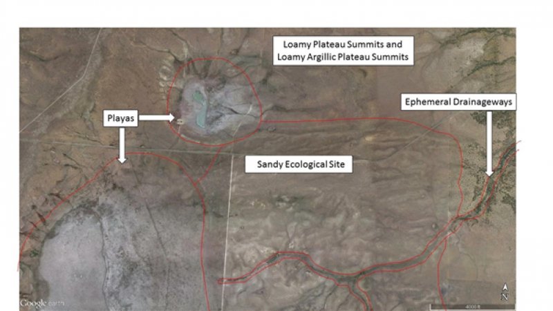
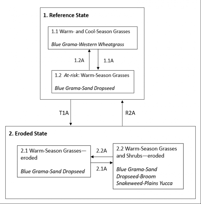
Ecological dynamics
Plant tables have not been developed for this site. Until such time as they can be updated, use the plant tables in the referenced literature that correlates to this concept (refer to tables in the Correlation to Current Ecological Sites section below). With respect to the imperfect alignment of such correlations, be aware of these shortcomings in their applicability to conservation planning.
Because this site is not extensive, and because much of the Canadian Plateaus was not accessible during contemporary fieldwork, the dataset used to develop the State and Transition Model (STM) below is quite limited in its extent.
There are numerous variables which affect the range of characteristics for this ecological site. Variables such as elevation, latitude, and orographic effects create a climatic gradient which influence the distribution of C3 and C4 plants. Soil properties such as surface texture, depth to clay layer, parent material, and accumulated salts affect species diversity and composition. Natural disturbances such as drought and wildfire affect species density and cover.
The climate gradient across the CP LRU shows a greater distribution of C3 plants such as western wheatgrass and bottlebrush squirreltail where temperatures are cooler, and moisture is more abundant. Where surface texture trends toward clay loam, western wheatgrass, galleta, and vine mesquite increase. In areas of sandier surface textures, sideoats grama and sand dropseed are more likely to occur.
Grazing pressure will tend to favor grasses such as sand dropseed, blue grama, and purple threeawn, as well as shrubs such as broom snakeweed and fringed sagebrush.
Within this site, the dominant species of short grasses are inherently drought- and grazing-tolerant (Lauenroth, et al., 1994). Across the western parts of the U.S., blue grama is one of the most extensively distributed grasses and occurs in a wide variety of different ecosites ranging from grasslands to shrubland and woodland sites. This grass evolved with grazing by large herbivores and, when grazed continuously, tends to form a short sod. When allowed to grow under lower grazing pressures, the plants develop the upright physiognomy of a bunchgrass. If blue grama is eliminated from an area by extended drought (3-4 years) or disturbance such as plowing, regeneration is slow because of very slow tillering rates (Samuel, 1985), low and variable seed production, minimal seed storage in the soil (Coffin, 1989) and limited seedling germination and establishment due to particular temperature and extended soil moisture requirements for successful seedling establishment (Briske, 1978). Buffalograss, which is more abundant at warmer, lower elevations of this site, is often found occupying swale or depression positions across the landscape. Buffalograss is less drought-tolerant than blue grama but re-establishes more quickly following disturbance due to higher seed abundance and viability and more effective above-ground tillering (Peters, 2008).
Large-scale processes such as climate, fire, and grazing influence this site. During years with favorable growing seasons, the effects of grazing may be mitigated. During years of low precipitation, grazing can magnify degradation of the site (Milchunas D.G., 1989). Fire is a natural disturbance regime that suppresses succulents and shrubs while stimulating grasses and forbs, however, in contrast to mid and tall grass prairie sites, fire is less important (Wright, 1982). This is because the drier conditions produce less vegetation/fuel load, lowering the relative fire frequency. However, historically, fires that did occur were often very expansive, especially after a series of years where above average precipitation built enough litter/fine fuels. Currently, fire suppression and more extensive grazing in the region have decreased the fire frequency, and it is unlikely that these processes could occur at a natural scale (USNVC, 2017)-G144. According to (Gebow, 2001), fire effects in the same location will vary, especially with fire timing, where seasonality can either hinder or benefit plants depending on their growing stage. Precipitation events occurring before and after fire will also influence the recovery of plants. Fire promotes rhizomatous plant species, such as western wheatgrass, that can take advantage of below-ground rhizomes from which tillering is rapidly initiated.
Correlation to Legacy Ecological Sites:
The Sandy site has been mostly correlated to legacy soil components from the Deep Loamy Plains (R077BY034NM) site. It was also linked to components correlated to the High Sandy Loam (R077BY035NM) site. Being MLRA 77B sites, these sites are lower in elevation, therefore warmer; and further east, therefore moister than MLRA 70A, but should exhibit some similarities to these plant communities, and will serve as useful references. The Sandy Plains ecological site (R070AY012NM) has many similarities to the new Sandy site.
From Sandy Plains ecological site (R070AY012NM)
This site is suitable for grazing during all seasons of the year and by all classes of livestock. Approximately 95 percent of the total annual yield are from species which provide good feed and good nutrition for livestock. Continuous yearlong grazing or grazing during the period from April through October will result in a plant community of sand dropseed, threeawn, red lovegrass, sand sagebrush, and yucca. A system of deferred grazing, which varies the season of grazing and rest in pastures, is needed to maintain a healthy, well-balanced plant community. Periods of rest during the spring (April-June) will allow cool-season grasses such as New Mexico feathergrass* and various forbs to grow and to reproduce. Rest during this period is also beneficial to allow grasses such as sand bluestem and Indian ricegrass a period of green up before being grazed. Rest during the summer (July-September) is most beneficial to the warm-season grasses and forbs such as sand bluestem, sideoats grama, Indian ricegrass, little bluestem, blue grama, and various forbs.
*New Mexico feathergrass is quite rare on R070AA021NM. However, the statement in question applies to other cool-season grasses such as Western wheatgrass and bottlebrush squirreltail.
Sandy Plains (R070AY012NM) tables
Annual production by plant type
Plant Type----------Low(Lb/Acre) ----------Representative Value(Lb/Acre) ----------High(Lb/Acre)
Grass/Grasslike----------680------------------------------1340----------------------------------------2500
Forb-------------------------102-----------------------------201------------------------------------------300
Shrub/Vine----------------68-------------------------------134------------------------------------------200
Total-------------------------850-----------------------------1675----------------------------------------3000
Community 1.1 plant community composition
Common Name----------Symbol----------Scientific Name----------Annual Production (Lb/Acre)
GRASS/GRASSLIKE
1 little bluestem----------SCSC------------Schizachyrium scoparium----------335–419
2 sideoats grama----------BOCU----------Bouteloua curtipendula------------251–285
3 sand bluestem----------ANHA-----------Andropogon hallii-------------------84–117
4 Indian ricegrass----------ACHY-----------Achnatherum hymenoides-------84–117
5 blue grama---------------BOGR2----------Bouteloua gracilis-------------------251–285
6 New Mexico feathergrass-HENE5-----Hesperostipa neomexicana--------84–117
7 sand dropseed-----------SPCR------------Sporobolus cryptandrus------------84–117
8 red lovegrass------------ERSE-------------Eragrostis secundiflora-------------50–84
9 threeawn-----------------ARIST-------------Aristida--------------------------------50–84
10 sand muhly--------------MUAR2--------Muhlenbergia arenicola-------------50–84
FORB
11 globemallow----------SPHAE-----------Sphaeralcea----------------------------50–84
12 ragwort-----------------SENEC-----------Senecio----------------------------------17–50
13 pigweed----------------AMARA----------Amaranthus----------------------------50–84
14 goosefoot--------------CHENO----------Chenopodium-------------------------50–84
15 annual buckwheat---ERAN4-----------Eriogonum annuum------------------50–84
16 buckwheat-------------ERIOG-----------Eriogonum------------------------------50–84
14 golden pricklypoppy-ARAE------------Argemone aenea----------------------0–34
15 bladderpod-------------LESQU----------Lesquerella------------------------------17–50
16 lemon scurfpea--------PSLA3----------Psoralidium lanceolatum----------0–50
17 Adonis blazingstar-----MEMU3-------Mentzelia multiflora----------------17–50
18 gilia-------------------------GILIA----------Gilia-------------------------------------0–34
19 silverleaf nightshade----SOEL---------Solanum elaeagnifolium------------0–34
20 aster------------------------ASTER--------Aster------------------------------------17–50
21 goldenweed--------------PYRRO--------Pyrrocoma------------------------------0–34
22 sunflower-----------------HELIA3--------Helianthus-----------------------------34–67
SHRUB/VINE
23 sand sagebrush----------ARFI2----------Artemisia filifolia--------------------50–84
24 yucca------------------------YUCCA--------Yucca-----------------------------------50–84
25 winterfat-------------------KRLA2--------Krascheninnikovia lanata-----------17–50
-----------------------------------------------------------------------------------------------------------------------------------
From High Sandy Loam ecological site (R077BY035NM) – a site outside of the MLRA area and concept*:
Historic Climax Plant Community
This site is a grassland dominated by warm-season short and mid-grasses. Cool-season grasses and forbs make up an important component of the plant community. Woody species are a minor component.
Other grasses that could appear on this site include: sand muhly, buffalograss, silver bluestem, sand bluestem, switchgrass, sand paspalum, and Indiangrass.
Other forbs include: scrufpea, prairie clover, western ragweed, New Mexico thistle, woolly
Indianwheat and whorl-leaf milkweed.
*MLRA 77B is warmer than and receives more summer moisture than does 70A, and this is reflected in many of the species described here. While yellow Indiangrass and switchgrass have been observed in trace amounts in the CP, they have not been recorded in areas that correlate the GX070A01X021 site.
High Sandy Loam (R077BY035NM) tables
Annual production by plant type
Plant Type-------------Low(Lb/Acre) -------------Representative Value(Lb/Acre) -------------High(Lb/Acre)
Grass/Grasslike-------------706---------------------------------------1100---------------------------------------1494
Forb--------------------------68---------------------------------------106---------------------------------------144
Shrub/Vine-------------34----------------------------------------------------53--------------------------72
Total-------------808---------------------------------------1259---------------------------------------1710
Community 1.1 plant community composition
Common Name-------------Symbol-------------Scientific Name-------------Annual Production (Lb/Acre)
GRASS/GRASSLIKE
1-------------Blue and Hairy Grama-------------265–331
blue grama--------------------BOGR2-------------Bouteloua gracilis-------------265–331
hairy grama-------------------BOHI2--------------Bouteloua hirsuta-------------265–331
2-------------Sideoats Grama-------------199–265
sideoats grama----------------BOCU-------------Bouteloua curtipendula-------199–265
3-------------Little Bluestem-------------133–199
little bluestem-----------------SCSC--------------Schizachyrium scoparium-------133–199
4-------------NM feathergrass and Needleandthread--------------133–199
needle and thread-------------HECO26---------Hesperostipa comata-------------133–199
New Mexico feathergrass----HENE5-----------Hesperostipa neomexicana-----133–199
5-------------Sand dropseed-------------66–133
sand dropseed-------------------SPCR-------------Sporobolus cryptandrus-----------66–133
6-------------red lovegrass and tumble lovegrass-------------66–133
red lovegrass---------------------ERSE--------------Eragrostis secundiflora-------------66–133
tumble lovegrass-----------------ERSE2------------Eragrostis sessilispica--------------66–133
7-------------Galleta-------------40–66
James' galleta---------------------PLJA--------------Pleuraphis jamesii-------------------40–66
8-------------Threeawn spp. -------------40–66
threeawn--------------------------ARIST-------------Aristida---------------------------------40–66
9-------------Other grasses-------------40–66
Graminoid------------------------2GRAM-----------Graminoid--------------------------40–66
FORB
10-------------Sunflower Buckwheat globemallow sensitive briar-------------40–66
buckwheat-----------------------ERIOG-------------Eriogonum--------------------------40–66
sunflower------------------------HELIA3-------------Helianthus--------------------------40–66
Nuttall's sensitive-briar--------MINU6-----------Mimosa nuttallii-------------------40–66
globemallow---------------------SPHAE-------------Sphaeralcea------------------------40–66
SHRUB/VINE
11-------------Sand sage soapweed yucca winterfat groundsel spp.-------------40–66
sand sagebrush-----------------ARFI2-------------Artemisia filifolia------------------40–66
winterfat--------------------------KRLA2------------Krascheninnikovia lanata--------40–66
ragwort----------------------------SENEC------------Senecio------------------------------40–66
soapweed yucca-----------------YUGL-------------Yucca glauca------------------------40–66
------------------------------------------------------------------------------------------------------------------------
From Deep Loamy Plains ecological site (R077BY034NM), a site outside of the MLRA area and concept*:
Historic Climax Plant Community
This site is a grassland dominated by warm-season mid-grasses. Tall grasses, cool-season
grasses and forbs make up an important component of the plant community. Woody plants make up a minor component
Other grasses that could appear on this site include: red lovegrass, sand muhly, threeawn spp., tumble lovegrass, paspalum, dryland sedge, hooded windmill grass, and silver bluestem.
Other shrubs include: threadleaf groundsel and broom snakeweed.
Other forbs include: silky prairie clover, scurfpea, western ragweed, gilia, silverleaf nightshade, prickly poppy, and bladderpod.
Deep Loamy Plains (R077BY034NM) Tables
Annual production by plant type
Plant Type-------------Low(Lb/Acre)----------Representative Value(Lb/Acre) ----------High(Lb/Acre)
Grass/Grasslike-----------1095--------------------------------1570-------------------------------2044
Shrub/Vine-----------------165----------------------------------237--------------------------------308
Forb--------------------------120----------------------------------172--------------------------------244
Total-------------------------1380---------------------------------1979------------------------------2596
Community 1.1 plant community composition
Common Name----------Symbol----------Scientific Name----------Annual Production (Lb/Acre)
GRASS/GRASSLIKE
1----------Sand Bluestem----------323–430
sand bluestem------------ANHA------------Andropogon hallii----------------323–430
2----------Little Bluestem----------323–430
little bluestem------------SCSC--------------Schizachyrium scoparium------323–430
3----------NM Feathergrass, Needleandthread----------323–430
needle and thread--------HECO26---------Hesperostipa comata------------323–430
New Mexico feathergrass-HENE5---------Hesperostipa neomexicana----323–430
4----------Sideoats grama ----------215–323
sideoats grama-------------BOCU-------------Bouteloua curtipendula--------215–323
5---------- Grama----------108–215
blue grama------------------BOGR2------------Bouteloua gracilis----------------108–215
hairy grama-----------------BOHI2-------------Bouteloua hirsuta----------------108–215
6----------Indiangrass Switchgrass----------108–215
switchgrass------------------PAVI2-------------Panicum virgatum----------------108–215
Indiangrass------------------SONU2------------Sorghastrum nutans-------------108–215
7----------Indian ricegrass----------108–215
Indian ricegrass-------------ACHY--------------Achnatherum hymenoides-----108–215
8----------giant spike sand dropseeds----------65–108
spike dropseed--------------SPCO4------------Sporobolus contractus----------65–108
sand dropseed---------------SPCR------------Sporobolus cryptandrus------------65–108
giant dropseed---------------SPGI-------------Sporobolus giganteus---------------65–108
9----------other grasses----------65–108
Graminoid (grass or grass-like)-2GRAM---(grass or grass-like)-----------------65–108
FORB
10----------Buckwheat sunflower globemallow stickleaf----------65–108
buckwheat--------------------ERIOG-----------Eriogonum-----------------------------65–108
sunflower---------------------HELIA3-----------Helianthus-----------------------------65–108
Adonis blazingstar----------MEMU3---------Mentzelia multiflora-----------------65–108
globemallow------------------SPHAE-----------Sphaeralcea----------------------------65–108
11----------Other forbs----------65–108
Forb (herbaceous) ----------2FORB------------Forb-------------------------------------65–108
SHRUB/VINE
12----------Sand sagebrush----------108–215
sand sagebrush---------------ARFI2------------Artemisia filifolia----------------------108–215
13----------yucca skunkbush sumac----------65–323
skunkbush sumac-------------RHTR------------Rhus trilobata--------------------------65–323
yucca------------------------------YUCCA---------Yucca-------------------------------------65–323
14----------Other shrubs----------65–108
Shrub, deciduous---------------2SD-------------Shrub, deciduous---------------------65–108
----------------------------------------------------------------------------------------------------------------------------------
From San Miguel County NM630 Manuscript – Manter loamy find sand, undulating map unit description:
“The potential plant community in this unit is mainly blue grama, Indian ricegrass, needlegrass, sand dropseed, and western wheatgrass. As the range deteriorates, the proportion of these forage plants decreases and the proportion of sand dropseed, yucca, sand sagebrush, and broom snakeweed increases. Grazing management should be designed to increase the productivity and reproduction of western wheatgrass, Indian ricegrass, New Mexico feathergrass, and blue grama.”
From NM630 Manuscript - Sandy Plains site:*
The approximate species composition of the potential plant community is as follows:
Blue grama-----------------------------------------------15
Indian ricegrass------------------------------------------15
Needlegrass----------------------------------------------10
Sand dropseed----------------------------------------10
Bottlebrush squirreltail--------------------------------7
Western wheatgrass------------------------------------7
Little bluestem---------------------------------------5
Sand sagebrush---------------------------------------5
Productivity in pounds per acre ranges from 950 to 1,800 with 1,400 being a normal value.
*The Manter component is no longer correlated to the Sandy Plains site. However, this old manuscript plant information appears to fit this ecological site better than the currently correlated site.
State 1
Reference State
This state represents the most ecologically stable state in terms of resistance to erosion. Moreover, this state has the highest potential for productivity and plant diversity.
Community 1.1
Warm- and Cool-Season Grasses (diagnostic plant community)
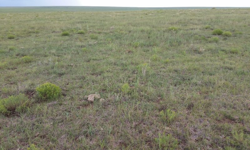
Figure 4. Community 1.1 in San Miguel County, August 2017. This site had recently experienced relatively heavy grazing.
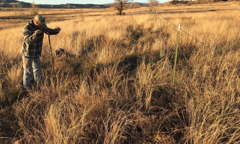
Figure 5. Community 1.1 in Colfax County, November 2018. This observation likely captures the upper limit of production for this site. It occurred in an interstate right-of-way which had experienced prolonged rest from grazing.
This community is dominated by grasses, but also contains a mix of forbs and shrubs. Foliar cover is between 75 and 90 percent, and bare ground is typically less than 20 percent. Total canopy cover of warm-season grasses is between 40 and 65 percent, and cool-season grass cover typically ranges from 10 to 60 percent. Shrubs and forbs each account for less than 5 percent cover. Annual production averages around 1,300 pounds per acre, but can range between 850 and 2,000 pounds per acre, depending mostly on annual weather patterns.
This community typically occurs where season-long grazing has not been practiced in a number of years, or at least where this practice has been periodically deferred. Blue grama is most often the dominant grass, but is typically codominant to Western wheatgrass. Sand dropseed is also a major player. Shrubs are ever present, with broom snakeweed being most dominant, followed by Plains yucca. At the higher/cooler end of the spatial/climatic gradient (along the western fringes of the LRU), fringed sagebrush is often codominant to broom snakeweed. Forb diversity can be relatively high, but varies considerably within this phase. Topsoil remains in-place, and most often meets the criteria for a mollic epipedon.
High canopy cover protects the topsoils from wind erosion. Sandy textures and relatively strong soil structure at the surface prevent erosive runoff.
While this appears to be the latest-seral community that currently occupies this site, it still exhibits evidence of past disturbance (weedy species and signs of erosion), and is by no means reflective of “pristine” pre-Columbian conditions. During early observations of this plant community, it was considered at-risk of crossing the threshold into State 2. However, later-seral communities have not been identified since. Legacy information from the San Miguel County Soil Survey manuscript suggests that Indian ricegrass should be an important component of Community 1.1, but this species has only been observed in trace amounts on this site during contemporary fieldwork.
Community 1.2
At-Risk: Warm-Season Grasses
This community is dominated by grasses, but also contains a mix of forbs and shrubs. Foliar cover is between 65 and 85 percent, and bare ground is typically less than 30 percent. Total canopy cover of warm season grasses is between 60 and 80 percent, and cool-season grass cover is below 5 percent. Shrubs and forbs each account for less than 5 percent cover. Annual production averages around 1,100 pounds per acre, but can range between 800 and 1,400 pounds per acre, depending mostly on annual weather patterns.
This community occurs in areas with histories of prolonged, season-long grazing. Blue grama is the dominant grass, and is typically in a sod-bound state. Sand dropseed is also a major player. Shrubs are ever present, with broom snakeweed being most dominant, followed by Plains yucca. At the higher/cooler end of the spatial/climatic gradient (along the western fringes of the LRU), fringed sagebrush is often codominant to broom snakeweed. Forb diversity can be relatively high, but varies considerably within this phase. Topsoil is somewhat degraded, but still typically meets the criteria for a mollic epipedon.
Pathway P1.1A
Community 1.1 to 1.2
This pathway represents a period of heavy grazing, typically season-long, in which ungulates tend to selectively graze cool-season grasses, particularly Western wheatgrass. While their total abundance does not necessarily increase, the dominance of warm-season grasses (particularly blue grama) does. Early-seral grasses such as purple threeawn also increase under continuous grazing. In contrast to many other sites in the CP, shrubs do not appear to increase in abundance within State 1.
Where plant cover is significantly diminished, wind erosion becomes evident.
Pathway P1.2A
Community 1.2 to 1.1
This pathway represents prescribed grazing or rest from grazing. In either case, herbaceous plants that are palatable and/or sensitive to grazing increase in vigor and abundance, and shrubs are at a competitive disadvantage. Since the main difference between communities 1.2 and 1.1 is in the abundance of Western wheatgrass, rest during the seed-set of this species is critical for its recovery.
State 2
Eroded State
This state exists where significant soil loss has occurred. The topsoil generally does not meet color or thickness requirements for a mollic epipedon.
Community 2.1
Warm-Season Grasses—Eroded
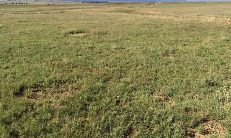
Figure 6. Community 2.1 in Colfax County, September 2017. Sod-bound blue grama is dominant here. Note the large patches of bare ground.
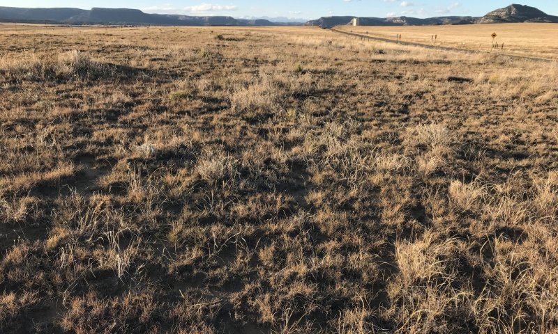
Figure 7. Community 2.1 in Colfax County, November 2018. Taller grasses here are mostly sand dropseed.
This plant community occurs on eroded soils—where productive potential and species diversity have been lost with topsoil and the seedbank it held. This community is dominated by grasses, but also contains a mix of forbs and shrubs. Foliar cover is between 65 and 85 percent, and bare ground is typically less than 30 percent. Total canopy cover of warm-season grasses is between 60 and 80 percent. Cool-season grasses are often absent; where present, they account for less than 2 percent. Shrubs and forbs each account for less than 5 percent cover. Oneseed juniper is occasionally present, but not in great numbers. Annual production averages around 900 pounds per acre, but can range between 700 and 1,100 pounds per acre, depending mostly on annual weather patterns.
This community occurs in areas with histories of prolonged, season-long grazing. Blue grama is the dominant grass, and is typically in a sod-bound state. Sand dropseed is also a major player. Shrubs are ever present, with broom snakeweed being most dominant, followed by Plains yucca. At the higher/cooler end of the spatial/climatic gradient (along the western fringes of the LRU), fringed sagebrush is often codominant to broom snakeweed. Forb diversity can be significant, but varies considerably within this phase. Topsoil is degraded, rarely meeting the criteria for a mollic epipedon.
Community 2.2
Warm-Season Grasses and Shrubs—Eroded
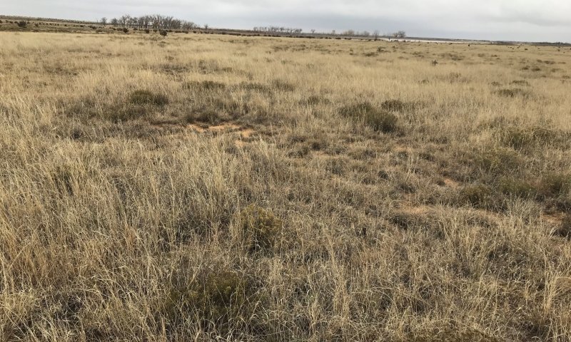
Figure 8. Community 2.2 in Colfax County, November 2018. Note the significant shrub cover and bare ground. Sand dropseed is codominant to blue grama at this location.
This plant community occurs on eroded soils—where productive potential and species diversity have been lost with topsoil and the seedbank it held. This community is dominated by grasses, but also contains a mix of forbs and shrubs. Foliar cover is between 65 and 85 percent, and bare ground is typically less than 30 percent. Total canopy cover of warm-season grasses is between 60 and 80 percent. Cool-season grasses are often absent; where present, they account for less than 2 percent. Shrub cover is at least 5 percent. Forbs generally account for less than 5 percent cover. Oneseed juniper is occasionally present, but not in great numbers. Annual production averages around 900 pounds per acre, but can range between 700 and 1,100 pounds per acre, depending mostly on annual weather patterns.
This community occurs in areas with histories of prolonged, season-long grazing, coupled with an absence of fire and chemical treatments. Blue grama either dominant or codominant to sand dropseed. Broom snakeweed is the dominant shrub. Plains yucca and walkingstick cholla are also common. At the higher/cooler end of the spatial/climatic gradient (along the western fringes of the LRU), fringed sagebrush is often codominant to broom snakeweed. Forb diversity can be significant, but varies considerably within this phase. Topsoil is degraded, rarely meeting the criteria for a mollic epipedon.
Pathway P2.1A
Community 2.1 to 2.2
Warm-Season Grasses—Eroded
Warm-Season Grasses and Shrubs—Eroded
This pathway represents conditions which advantage shrubs over grasses: continuous grazing and the absence of fire.
Pathway P2.2A
Community 2.2 to 2.1
Warm-Season Grasses and Shrubs—Eroded
Warm-Season Grasses—Eroded
This pathway represents conditions which advantage grasses over shrubs: prescribed grazing, fire, and/or herbicide application. Since significant fuel loads are required to carry a fire, deferred grazing may be a necessary precursor to prescribed fire.
Transition T1A
State 1 to 2
Slow variables: An extended period with reduced plant cover and heavy pressure on cool-season grasses. This result is an increase in the rate of wind erosion and further diminished abundance and vigor among cool-season grasses—particularly Western wheatgrass. Trigger event: A drought kills already-weakened perennial grasses, resulting in the extirpation of Western wheatgrass. This, in turn, accelerates erosion. The concurrent loss of topsoil depletes the seedbank, further altering plant community composition. Threshold: The vigor and cover of perennial grasses is reduced to a point at which some perennial grasses die.
Restoration pathway R2A
State 2 to 1
An increase in the competitive advantage of various perennial grass species through physical, chemical, and biological management practices. In this process, topsoil is at least somewhat restored in thickness and organic matter content. This restoration pathway will likely require long-term, multifaceted approaches and high-energy inputs. In order to return to State 1, erosion will have to be reversed, grazing will have to be tightly-controlled, and the re-introduction of extirpated plant species such as Western wheatgrass may be required. Favorable weather patterns may also be necessary.


