Ecological dynamics
The information contained in the State and Transition Diagram (STD) and the Ecological Site Description was developed using archeological and historical data, professional experience, and scientific studies. The information presented is representative of a very complex set of plant communities. Not all scenarios or plants are included. Key indicator plants, animals and ecological processes are described to inform land management decisions.
Like many ecosites throughout the great plains, the Loamy Upland site evolved under periodic fire and grazing events. The deep loamy soils support the growth of palatable vegetation for grazing and browsing animals. In the reference condition this vegetation is also capable of carrying fires across the landscape which, historically, has limited the encroachment of woody species. The deep rooted tallgrass species and good ground cover facilitated capture and infiltration of precipitation.
However, these productive soils were often overutilized by cattlemen or plowed up by the farmsteaders in the early 1900s. This lead to widespread erosion in some areas and depletion of the soil resources. While farming has ceased on many of these upland sites, abusive grazing practices still persist. Most acres that were farmed have been planted back to introduced species such as irrigated Bermudagrass, old world bluestems, or in some cases native species. While the monocultures of introduced species can address the soil erosion on these sites, they do little to restore the hydrologic or ecological function.
In the absence of prescribed fire or alternative brush management, woody species are likely to increase in abundance and stature. While these woody species may not increase enough to dominate ecological functions on the site, their presence can impact grazing access and wildlife habitat needs. It is important to note that mesquite is not found in abundance on these sites like it is on similar soils further south in the MLRA.
State and Transition Diagram:
A State and Transition Diagram for the Loamy Upland (R077EY056OK) site is depicted below. Thorough descriptions of each state, transition, and pathway follow the model. Experts base this model on available experimental research, field observations, professional consensus, and interpretations. It is likely to change as knowledge increases.
Plant communities will differ across the MLRA because of the natural variability in weather, soils, and aspect. The Reference Plant Community is not necessarily the management goal; other vegetative states may be desired plant communities as long as the Range Health assessments are in the moderate and above category. The biological processes on this site are complex. Therefore, representative values are presented in a land management context. The species lists are representative and are not botanical descriptions of all species occurring, or potentially occurring, on this site. They are not intended to cover every situation or the full range of conditions, species, and responses for the site. Composition by dry weight and percent canopy cover are provided to describing the functional groups. Most observers find it easier to visualize or estimate percent canopy for woody species (trees and shrubs).
The following diagram suggests some pathways that the vegetation on this site might take. There may be other states not shown on the diagram. This information is intended to show what might happen in a given set of circumstances. It does not mean that this would happen the same way in every instance. Local professional guidance should always be sought before pursuing a treatment scenario.
State 1
Grassland (R)
This is the reference or diagnostic community for the site. The description is based on early range site descriptions, clipping data, professional consensus of experienced range specialists, and analysis of field work.
Community 1.1
Tall/Midgrass

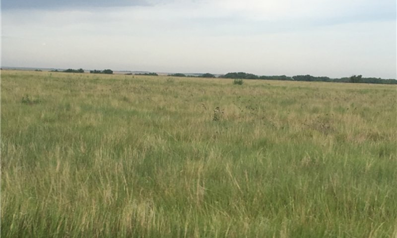
Figure 8. Reference community 1.1 Meade County KS
This is the reference community for the Loamy Upland site. The vegetation is dominated by mixed tallgrasses and midgrasses, mainly sand and little Bluestem. Sideoats grama may be abundant along with many perennial forbs and legumes. Minor amounts of woody species may occur including skunkbush, hackberry, or sandplum. Total annual production for this community is estimated to range from 1500 to 3500 pounds per acre.
Community 1.2
Mid/Shortgrass
This plant community is dominated by mid and shortgrasses such as sideoats grama and blue grama. Other species may include dropseed species, silver bluestem and some remnant little bluestem. There has been an increase in annual forbs and bare ground. With the absence of tallgrasses, the forage base for grazing livestock has been diminished and infiltration rate may have declined also.
Community 1.3
Woody Encroachment
This community phase has been encroached upon by woody species such as eastern Redcedar, Siberian elm, or others. While the woody species may not take expand enough to dominate the hydrologic or energy flow across the site, this is still an important community shift to identify. Particularly from a wildlife habitat standpoint.
Pathway 1.1A
Community 1.1 to 1.2
Abusive grazing practices that include stocking above carry capacity without adequate rest may push this community towards community 1.2 as the more palatable species are damaged. Additionally, long periods of drought may hinder the vigor of some of the tallgrasses and favor the more drought tolerant mid and short grasses.
Pathway 1.1B
Community 1.1 to 1.3
In the absence of fire or alternative brush management, woody species may encroach on the site pushing it to community 1.3.
Pathway 1.2A
Community 1.2 to 1.1
Through adequate rest from grazing and favorable growing season precipitation, this community may be shifted back to the reference community.
Pathway 1.2B
Community 1.2 to 1.3
In the absence of fire or alternative brush management, woody species may encroach on the site pushing it to community 1.3.
Pathway 1.3A
Community 1.3 to 1.1
Through the implementation of a prescribed fire or brush management program, couple with prescribed grazing, this community may be shifted back to the reference community.
Pathway 1.3B
Community 1.3 to 1.2
Through the implementation of a prescribed fire or brush management program without prescribed grazing, this community may be shifted to community phase 1.2.
State 2
Land Use Conversion
This is an alternative state from the reference. Hydrologic and ecological functions have been altered. The site is in current crop production or has been tilled and seeded to an introduced forage. The hydrology has been altered and requires different management. See Soil Survey or Extension publications for yield data.
State 3
Eroded
This is an alternative state from the reference. Hydrologic and ecological functions have been altered. This state is the result of water erosion over bare soil. Most of the "A" horizon of the soil profile has been displaced. The remaining subsoil is very low in fertility. Some native grasses and forbs will persist in this state, however, production is greatly reduced.
Transition T1A
State 1 to 2
Through tillage and seeding this site will transition to state 2.
Transition T2A
State 2 to 3
Cultivation of these sites has often lead to severe water and wind erosion.


