Ecological dynamics
The information contained in the State and Transition Diagram (STD) and the Ecological Site Description was developed using archeological and historical data, professional experience, and scientific studies. The information presented is representative of a very complex set of plant communities. Not all scenarios or plants are included. Key indicator plants, animals and ecological processes are described to inform land management decisions.
These Depression sites are unique features on the high plains. The availability of surface water has always been a draw for wild and domestic animals. As with most other Great Plains ecosites, these areas evolved under periodic fires and grazing events. However, differing from many other sites, frequency and duration of inundation is the primary driver of the plant community. The longer the site is covered in water, the more hydrophytic plants will dominate the community. As these sites dry up for long periods of time, the hydrophytes will decline and give way to more midgrasses and shortgrasses.
Many of these areas have been altered from their historical hydrology. Through cultivation, land leveling, and field draining, many of the formerly closed depressions have been drained or filled. However, there are many sites that remain intact due to the perennial wetness that is not conducive to farming.
State and Transition Diagram:
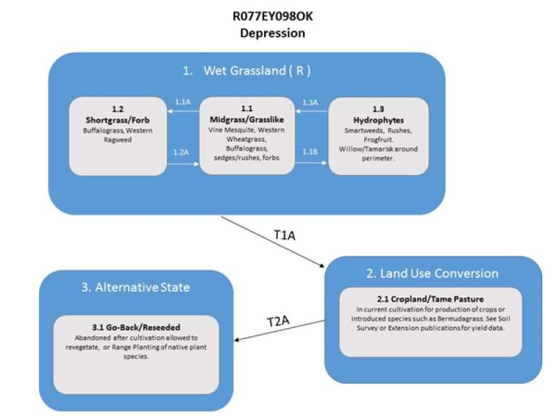
A State and Transition Diagram for the Depression (R077EY098OK) site is depicted below. Thorough descriptions of each state, transition, and pathway follow the model. Experts base this model on available experimental research, field observations, professional consensus, and interpretations. It is likely to change as knowledge increases.
Plant communities will differ across the MLRA because of the natural variability in weather, soils, and aspect. The Reference Plant Community is not necessarily the management goal; other vegetative states may be desired plant communities as long as the Range Health assessments are in the moderate and above category.
The biological processes on this site are complex. Therefore, representative values are presented in a land management context. The species lists are representative and are not botanical descriptions of all species occurring, or potentially occurring, on this site. They are not intended to cover every situation or the full range of conditions, species, and responses for the site.
The following diagram suggests some pathways that the vegetation on this site might take. There may be other states not shown on the diagram. This information is intended to show what might happen in a given set of circumstances. It does not mean that this would happen the same way in every instance. Local professional guidance should always be sought before pursuing a treatment scenario.
State 1
Wet Grassland (R)
This is the reference or diagnostic community for the site. The description is based on early range site descriptions, clipping data, professional consensus of experienced range specialists, and analysis of field work.
This reference state represents the natural variability of the fluctuating plant community that evolved under the historical disturbance regime. Through periodic drought and wet periods the vegetation may shift back and forth across these “community phases” without crossing an ecological threshold.
Dominant plant species
-
sedge (Carex), other herbaceous
-
rush (Juncus), other herbaceous
-
bulrush (Scirpus), other herbaceous
Community 1.1
Midgrass/Grasslikes

Figure 8. Rosston series. Harper County, OK
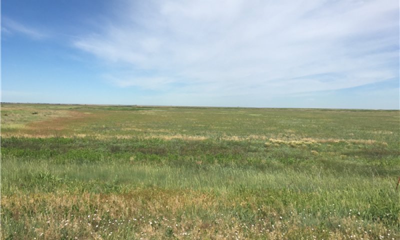
This is the reference plant community for the Depression site. The plant community is dominated by midgrasses and grasslike plants. Midgrasses include species that can with stand wet soil conditions for short periods such as vine mesquite and western wheatgrass. Grasslikes include many species of sedges (Carex spp.), rushes (Juncus spp.) and bulrushes (Scirpus spp.). Buffalograss and various forbs also occur in this community phase. Annual vegetative production is estimated at 1,400 to 3,000 pounds per acre.
Community 1.2
Shortgrass/Forb
If the depression site stays dry for prolonged periods, the plant community may shift toward species adapted to dry conditions. Buffalograss and other shortgrasses may dominate along with numerous forbs such as western ragweed and others.
Community 1.3
Hydrophytes
Prolonged inundation may lead to a plant community dominated by hydrophytic plants. Many aquatic plants including smartweeds (Polygonum spp.), and rushes may dominate the site. Some woody plants including willows (Salix spp.) and Tamarisk may occupy the edges of the ponded water.
Pathway 1.1A
Community 1.1 to 1.2
Over long dry periods, this community may shift towards community 1.2 as the clay soils dry out.
Pathway 1.1B
Community 1.1 to 1.3
Over long wet periods, this community may shift towards community 1.3 as water is ponded for long periods and favors many hydrophytic species.
Pathway 1.2A
Community 1.2 to 1.1
With the return of o favorable precipitation cycle, the community may shift back towards community 1.1
Pathway 1.3A
Community 1.3 to 1.1
As the water evaporates and the depressions dry out, the plant community may shift toward community 1.1.
State 2
Land Use Conversion
This is an alternative state from the reference. Hydrologic and ecological functions have been altered.
Community 2.1
Cropland/Tame Pasture
This community phase is in current crop production or has been tilled and seeded to an introduced forage. The hydrology has been altered and requires different management. See Soil Survey or Extension publications for yield data.
State 3
Alternative State
This is an alternative state from the reference. Hydrologic and ecological functions have been altered.
Community 3.1
Go Back/Reseeded
This plant community is the result of abandonment or range seeding after crop production ends. The plant community will be highly variable depending on seed sources, precipitation patterns and management. Consult your local field office for a site specific management plan.
Transition T1A
State 1 to 2
Through cultivation and seeding these sites may be converted to crop production or introduced forages.
Transition T2A
State 2 to 3
If cultivation is ceased, the site may be reseeded or left to re-vegetate naturally.


