Natural Resources
Conservation Service
Ecological site R102AY037SD
Deep Marsh
Last updated: 5/05/2025
Accessed: 02/07/2026
General information
Provisional. A provisional ecological site description has undergone quality control and quality assurance review. It contains a working state and transition model and enough information to identify the ecological site.
MLRA notes
Major Land Resource Area (MLRA): 102A–Rolling Till Prairie
The Rolling Till Prairie (102A) is located within the Central Feed Grains and Livestock Land Resource Region. It spans 3 states (Minnesota 58 percent, South Dakota 42 percent, and small part in North Dakota), encompassing over 16,000 square miles (Figure 1). The elevation ranges from approximately over 2,000 feet above sea level (ASL) on the Prairie Coteau in Northeastern South Dakota to about 1,000 feet ASL on lowlands. The dominate landform in this area are stagnation moraines, end moraines, glacial outwash plains, terraces, and flood plains. The area is dominated by till covered moraines. The stagnation moraines are gently undulating to steep and have many depressions and poorly defined drainages. Small outwash areas are adjacent to the watercourses. The Cretaceous Pierre Shale underlies the till in the most of the area. Precambrian rocks also occur at depth. Granite is quarried near Milbank, South Dakota and outcrops of Sioux Quartzite are common. (USDA-NRCS 2006).
The dominant soil order in this MLRA is Mollisols. The soils in the area dominantly have a frigid soil temperature regime, an aquic or udic soil moisture regime, and mixed mineralogy. They generally are very deep, well drained to very poorly drained. This area supports true prairie vegetation characterized by big bluestem (Andropogon gerardii), little bluestem (Schizachyrium scoparium), porcupinegrass (Hesperostipa spartea), and green needlegrass (Nassella viridula). Prairie cordgrass (Spartina pectinata) commonly grows in wet areas. (USDA-NRCS 2006).
Classification relationships
Major Land Resource Area (MLRA): Rolling Till Prairie (102A) (USDA-NRCS 2006)
USFS Subregions: North Central Glaciated Plains Section (251B); Upper Minnesota River-Des Moines Lobe Subsection (251Ba); Outer Coteau des Prairies Subsection (251Bb); Northwest Iowa Plains Subsection (251Bd); Minnesota and Northeast Iowa Morainal-Oak Savannah Section (222M); Alexandria Moraine-Hardwood Hills Subsection (222Ma) (Cleland et al. 2007).
US EPA Level IV Ecoregion: Tewaukon/Big Stone Stagnation Moraine (46e), Prairie Coteau (46k), Prairie Coteau Escarpment (46l), Big Sioux Basin (46m), Minnesota River Prairie (46o), Des Moines Lobe (47b) , Lake Agassiz Plains (48d), Alexandria Moraines and Detroit Lakes Outwash Plain (51j) (USEPA 2013)
Ecological site concept
The Deep Marsh Ecological Site typically represents the central portion of a wetland basin or depression on a glaciated prairie landscape with standing water up to 5 feet deep, and at least some tall, emergent vegetation like cattails, bulrushes and reeds. In most years there is at least some standing water but in drought years the basin surface may dry out yet retain groundwater within 1 foot of the surface.
Associated sites
| R102AY001SD |
Shallow Marsh These sites occur in a basin or closed depression. Soils are very poorly drained and the site will pond water until early summer in most years. The central concept soil series is Parnell and Oldham, but other series are included. |
|---|---|
| R102AY002SD |
Linear Meadow These sites occur in drainageways or along the edges of closed depressions. Soils are poorly and very poorly drained which have a water table within 0 to 2 feet of the soil surface that persists longer than the wettest part of the growing season typically until the month of August. The central concept soil series are Vallers and Colvin, but other series are included. |
| R102AY006SD |
Limy Subirrigated These sites occur along the edges of drainageways. Soils are somewhat poorly drained which have a water table within 2 to 5 feet of the soil surface that persists longer than the wettest part of the growing season typically until the month of August. Soils will effervesce with acid at or near the surface. The central concept soil series is Cubden, Hamerly, McKranz, but other series are included. |
| R102AY010SD |
Loamy These sites occur on upland areas. The soils are well drained and have less than 40 percent clay in the surface and subsoil. The central concept soil series is Barnes, Forman, and Poinsett, but other series are included. |
Similar sites
| R102AY001SD |
Shallow Marsh The Shallow Marsh site is in a similar landscape position, but the site ponds water until early summer in most years. The Shallow Marsh site will have none to very little cattails and more prairie cordgrass than a Deep Marsh site. |
|---|
Table 1. Dominant plant species
| Tree |
Not specified |
|---|---|
| Shrub |
Not specified |
| Herbaceous |
(1) Typha latifolia |
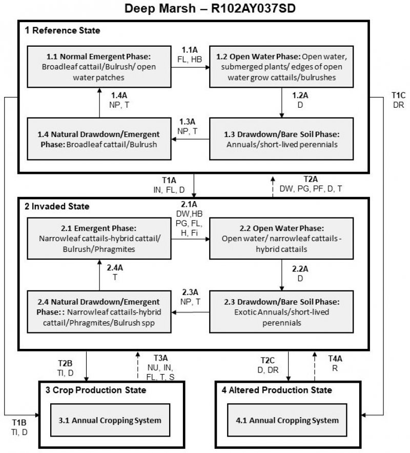
Click on box and path labels to scroll to the respective text.
Ecosystem states
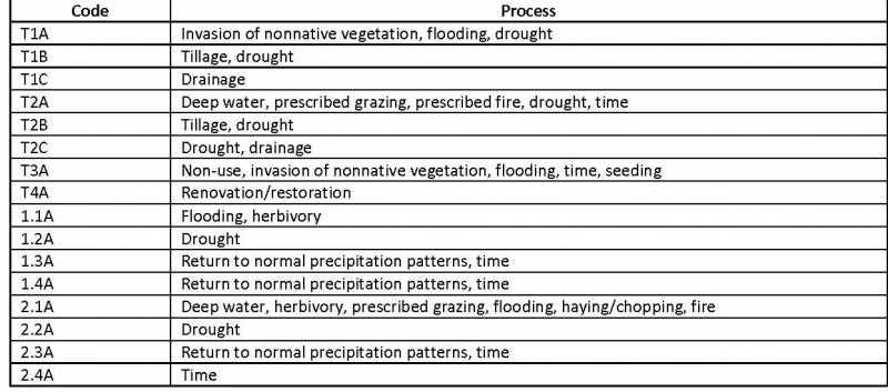
| T1A | - | Species invasion, flooding, and drought |
|---|---|---|
| T1B | - | Drought and tillage |
| T1C | - | Drainage |
| T2A | - | Deep water or drought, prescribed grazing, prescribed burning, time |
| T2B | - | Time and drought |
| T2C | - | Drought and drainage |
| T3A | - | Non-use, flooding, invasives, time, seeding |
| T4A | - | Renovation/Restoration |
State 1 submodel, plant communities
| 1.1A | - | Excessive flooding, herbivory activity |
|---|---|---|
| 1.2A | - | Drought |
| 1.3A | - | Normal precipitation and time |
| 1.4A | - | Return to normal precipitation patterns, and time |
State 2 submodel, plant communities
| 2.1A | - | Deep water, herbivory, prescribed grazing, and/or flooding |
|---|---|---|
| 2.2A | - | Drought |
| 2.3A | - | Normal precipitation and time |
| 2.4A | - | Time |

