Ecological dynamics
Shallow Peatland typically occur on level or slightly concave landscape positions, (slopes 0 – 1%) on depressions in uplands, along streams and drainageways, and less often as floating mats on lakeshores. Soil surface textures are muck or sapric peat (Histic Humaquepts to Terric Haplosaprists). Organic sediments are typically shallow, but can be >16 inches (40 cm) deep. Soils are very poorly drained, formed in thin mantles of highly decomposed organic soil material, overlying loamy, calcareous till or lacustrine sediments on lake plains, glacial moraines, and till plains. Permeability is moderate in the organic material, rapid in the sandy sediments, and moderate or moderately slow in the underlying loamy material.
The water table can be close to the surface or up to a depth of 1.0 foot during the growing season in an average precipitation year. Flooding is usually rare to none, except in cases where the site is located at the bottom of slopes or is associated with seeps or lateral flow from groundwater or an adjacent stream channel. These sites usually receive water through precipitation, overland surface flow, and/or flow-through (lateral flow) from an adjacent stream channel, therefore the mineral and nutrient content is high. In some cases, such as stream terraces, floodplains, or beach ridges, they can receive groundwater discharge; however, the central concept for this site is that of a recharge closed depression system (Brinson 1993), palustrine fresh meadow/shrub swamp (Cowardin et al, 1979). These sites are subject to moderate inundation following spring thaw and heavy rains and periodic drawdowns during the summer months and drought, but water levels are typically high and persistent enough to prevent tree establishment. These sites are particularly important for their water quality protection functions, including the trapping of sediments and assimilation of nutrients, and stormwater and floodwater retention.
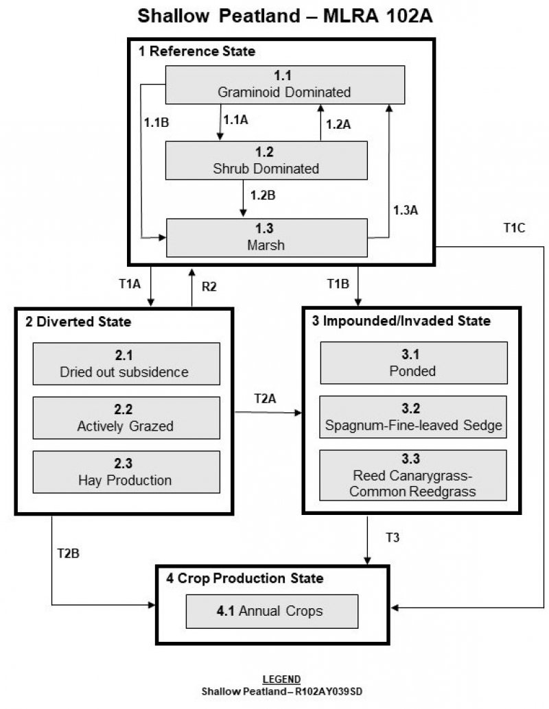
State 1
Reference State
The plants associated with the Shallow Peatland ecological site concept in the reference state are well-adapted to waterlogged conditions, but they cannot tolerate excessively long continuous periods of inundation (water table <20 in [50 cm]). Plant species are also adapted to periods of dessication, by developing root stems or collars that provide access to oxygen when the rest of the root system is submerged, or by having roots that extend very deep into permanently wet or moist substrates, or by having hard-walled cells (sclerenchyma) on the outer surfaces of their root systems which prevent water loss (MNDNR 2005). Although this site may temporarily exhibit floating or submergent vegetation, they typically do not last due to frequent periods of dessication on site. In situations where water levels are higher than average, or beaver impoundment is impacting the amount of water ponding on-site, the vegetation community may resemble more of a marsh. Tussock-forming sedges (i.e. Carex stricta Lam.) and bluejoint (Calamagrostis canadensis (Michx.) P. Beauv.) can form floating mats that elevate rootlets above the water surface. These thick mats also tend to reduce plant diversity and the available habitat on-site for forbs. Shrubs tend to dominate (alder, willow, dogwoods) on sites with more frequent draw-down of water or less frequent histories of fire. The transition of Shallow Peatland to a rich or poor fen is readily reversed by re-establishment of higher or more fluctuating water table or precipitation levels or impoundment, such as that from beaver activity. In reference condition, these sites provide important nesting and food sources for sand-hill cranes, pheasants, snipes, rails, songbirds, raptors, and small mammals.
Dominant plant species
-
red maple (Acer rubrum), tree
-
black ash (Fraxinus nigra), tree
-
American elm (Ulmus americana), tree
-
tamarack (Larix laricina), tree
-
paper birch (Betula papyrifera), tree
-
American red raspberry (Rubus idaeus), shrub
-
meadow willow (Salix petiolaris), shrub
-
pussy willow (Salix discolor), shrub
-
redosier dogwood (Cornus sericea), shrub
-
gray alder (Alnus incana), shrub
-
Bebb willow (Salix bebbiana), shrub
-
bog birch (Betula pumila), shrub
-
white meadowsweet (Spiraea alba), shrub
-
bluejoint (Calamagrostis canadensis), grass
-
hairy sedge (Carex lacustris), grass
-
Northwest Territory sedge (Carex utriculata), grass
-
water sedge (Carex aquatilis), grass
-
woolly sedge (Carex pellita), grass
-
prairie sedge (Carex prairea), grass
-
fowl mannagrass (Glyceria striata), grass
-
prairie cordgrass (Spartina pectinata), grass
-
common spikerush (Eleocharis palustris), grass
Community 1.1
Graminoid dominated
Frequent fires in the surrounding landscape may play an important role in on-site surface fires reducing peat accumulation as well as reducing the presence of trees and shrubs and increasing spring growth of sedges. Shrub cover <25%. Typical graminoids include bluejoint, hairy sedge (Carex lacustris Willd.), tussock sedge, Northwest Territory sedge (C. utriculata Boott), water sedge (C. aquatilis Wahlenb.), woolly sedge (C. pellita Muhl. ex Willd.), prairie sedge (C. prairea Dewey ex Alph. Wood), fowl mannagrass (Glyceria striata (Lam.) Hitchc.), prairie cordgrass (Spartina pectinate Bosc ex Link), and common spikerush (Eleocharis palustris (L.) Roem. & Schult.). Moss cover is usually <5% (brown mosses) but can become >75% (typically Sphagnum sp.). Seeps that are associated with calcareous fens or that occur on bases of slopes influenced by streams or lateral groundwater flow are typically dominated by aquatic sedge, prickly bog sedge (Carex interior L. H. Bailey), Sartwell’s sedge (C. sartwellii Dewey), and hardstem bulrush (Scirpus acutus (Muhl. ex Bigelow) Á. Löve & D. Löve). Shrub cover is commonly <25%. Common forbs include northern bog aster (Symphyotrichum boreale (Torr. & A. Gray) Á. Löve & D. Löve), marsh marigold (Caltha palustris L.), and water hemlock (Cicuta bulbifera L.). In areas adjacent to wet forests, where shade-tolerant species can thrive, and where there is a stronger connection to groundwater seepage which prevents tree establishment, this site concept can exhibit more forbs (Impatiens sp.) and less cover of sedges and graminoids.
Community 1.2
Shrub dominated
Open wetland with abundant broad-leaved graminoids, shrub cover >25%. Shrub cover can include American red raspberry (Rubus idaeus L.), meadow willow (Salix petiolaris Sm.), pussy willow (Salix discolor Muhl.), red-osier dogwood (Cornus sericea L), gray alder (Alnus incana L.), white meadowsweet (Spiraea alba Du Roi), Bebb willow (Salix bebbiana Sarg.), and bog birch (Betula pumila L.). If there are trees in the surrounding environment, tree species can include red maple (Acer rubrum L.), black ash (Fraxinus nigra Marshall), American elm (Ulmus Americana L.), tamarack (Larix laricina (Du Roi) K. Koch), and paper birch (Betula papyrifera Marshall).
Community 1.3
Marsh
Water is ponded on the surface throughout the duration of the growing season, converting vegetation temporarily to more aquatic or emergent vegetation, such as duckweed, pondweeds, native broadleaf cattail (Typha latifolia L), and rushes.
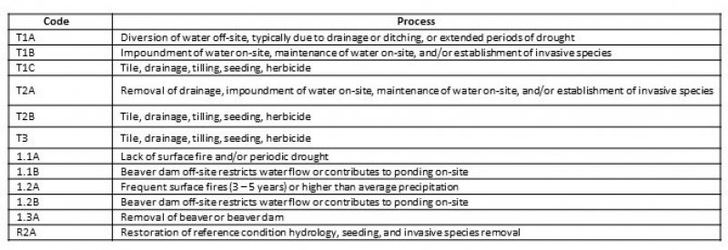
Pathway 1.1A
Community 1.1 to 1.2
Draw down of water levels, decreased precipitation/short drought periods, or prolonged periods without surface fire (>5 years) will likely lead this state over a threshold leading to the 1.2 Shrub Dominated Plant Community Phase.
Pathway 1.1B
Community 1.1 to 1.3
Beaver dams contribute to the ponding and retention of water on-site will likely lead this state over a threshold leading to the 1.3 Marsh Plant Community Phase.
Pathway 1.2A
Community 1.2 to 1.1
Frequent (3 – 5 year) surface fires would have converted this plant community to the 1.1 Graminoid Dominated Plant Community Phase.
Pathway 1.2B
Community 1.2 to 1.3
Beaver dams contribute to the ponding and retention of water on-site will likely lead this state over a threshold leading to the 1.3 Marsh Plant Community Phase.
Pathway 1.3A
Community 1.3 to 1.1
Removal of beaver, and/or the beaver dam, cessation of surface ponding, and restoration of fluctuations and draw-down of the water table periodically throughout the growing season would have converted this plant community to the 1.1 Graminoid Dominated Plant Community Phase.
State 2
Diverted State
Many areas that are drained are used for growing crops, hay, and pasture, or are used for grazing. Historically, a lot of these sites may have been ditched, or are adjacent to channels that have been channelized. Salinity can increase in soils that are drained or dried out for prolonged periods of time.
Community 2.1
Dried out subsidence
When water levels drop low enough, during periods of drought, or when water is prevented from entering or staying on the site due to diversion (such as roads or tile drainage), trees such as paper birch or aspen can become established. Shrub cover and presence of forbs will increase. Peat can become oxidized and subside. This phase can also become more susceptible to catastrophic burns, which can also reduce peat or prevent peat accumulation. Green bulrush (Scirpus atrovirens Willd.) often colonizes or increases in abundance when the peat is disturbed.
Community 2.2
Actively Grazed
When the hydrology of the site is altered, and the site is also managed for active grazing on a yearly basis, mana grasses and northern reed grass would be eaten first and would tend to decrease over time, increasing the abundance of sedges. Heavy grazing can increase compaction in the soil, and may increase or accentuate the presence of hummocks, vegetation tussocks, ridges, and rills.
Community 2.3
Hay Production
When the site is drained or ditched, hay production can be accomplished.
State 3
Impounded/Invaded State
This state describes three various ways in which the reference state changes to an altered state by either water impounding or invasion by reed canary grass or common reed or an increase in sphagnum species.
Community 3.1
Ponded
Hydrologic changes which result in a raising of the water table, or a prolongment of the inundation period, can result in conversion of the site concept to a marsh community, usually resulting in invasion by non-native cattail or hybrid cattail species (Typha angustifolia L., T. glauca L.). Occasionally these impounded phases are converted for wild rice production.
Community 3.2
Sphagnum-fine-leaved sedge
This Shallow Peatland site concept can be invaded by peat-producing bryophytes (sphagnum), causing a decline in nutrient levels and replacement of dominant broad-leaved sedges with fine-leaved sedges, leading to conversion to a true “peatland” plant community. Conversion to a rich fen can also occur after stabilization of water flow through the site, or when the site receives sedimentary deposition, contributing to peat accumulation.
Community 3.3
Reed canary grass/common reedgrass
Site hydrology is usually altered, either increasing flow to the site, or altering periodic drawdowns, etc. Invasion from reed canary grass (Phalaris arundinacea L.) or common reed grass (Phragmites australis (Cav.) Trin. ex Steud.) is the most common outcome, which displace native species and will produce monocultures within a short period of time if steps are not taken to eradicate their presence on-site. Proximity to invaded sites, heavy grazing, and/or an excess of nitrogen and phosphorus on-site from silt-laden runoff from agricultural land can also lead to invasion.
State 4
Crop Production State
This state is characterized by the production of annual crops using a variety of tillage and cropping systems along with management practices.
Community 4.1
Annual Crops
This plant community developed with the use of a variety of tillage systems and cropping systems for the production of annual crops including corn, soybeans, wheat, sugar beet and a variety of other crops.
Transition T1A
State 1 to 2
Tile drainage, ditching, diversion of surface flow, extreme prolonged drought will cause a shift over a threshold leading to the Diverted State (State 2).
Transition T1B
State 1 to 3
Artificial impoundment, roads, or any alteration in hydrology restricting water leaving the site or contributing excess water drainage to the site causing ponding and retention of water at the surface for prolonged periods of time throughout the growing season will cause a shift over a threshold leading to the Impounded/Invaded State (State 2).
Transition T1C
State 1 to 4
Tile drainage, tillage, seeding, and herbicides will cause a shift over a threshold leading to the 4.1 Annual Crops Plant Community Phase within the Crop Production State (State 4).
Restoration pathway R2
State 2 to 1
Reversal of drainage and maintenance of normal hydrology and water level fluctuations, seeding, and invasive species removal may lead this Diverted State (State 2) over a threshold to the Reference State (State 1).
Transition T2A
State 2 to 3
Removal of drainage, impoundment of water on-site, maintenance of water on-site, and/or establishment of invasive species will cause a shift over a threshold leading to the Impounded/Invaded State (State 3).
Transition T2B
State 2 to 4
Tile drainage, tillage, seeding, and herbicides will cause a shift over a threshold leading to the 4.1 Annual Crops Plant Community Phase within the Crop Production State (State 4).
Transition T3
State 3 to 4
Tile drainage, tillage, seeding, and herbicides will cause a shift over a threshold leading to the 4.1 Annual Crops Plant Community Phase within the Crop Production State (State 4).