Natural Resources
Conservation Service
Ecological site F115XC006IL
Loess Upland Flatwoods
Last updated: 12/30/2024
Accessed: 02/07/2026
General information
Provisional. A provisional ecological site description has undergone quality control and quality assurance review. It contains a working state and transition model and enough information to identify the ecological site.
MLRA notes
Major Land Resource Area (MLRA): 115X–Central Mississippi Valley Wooded Slopes
This MLRA is characterized by deeply dissected, loess-covered hills bordering well defined valleys of the Illinois, Mississippi, Missouri, Ohio, and Wabash Rivers and their tributaries. It is used to produce cash crops and livestock. About one-third of the area is forested, mostly on the steeper slopes. This area is in Illinois (50 percent), Missouri (36 percent), Indiana (13 percent), and Iowa (1 percent) in two separate areas. It makes up about 25,084 square miles (64,967 square kilometers).
Most of this area is in the Till Plains section and the Dissected Till Plains section of the Central Lowland province of the Interior Plains. The Springfield-Salem plateaus section of the Ozarks Plateaus province of the Interior Highlands occurs along the Missouri River and the Mississippi River south of the confluence with the Missouri River. The nearly level to very steep uplands are dissected by both large and small tributaries of the Illinois, Mississippi, Missouri, Ohio, and Wabash Rivers. The Ohio River flows along the southernmost boundary of this area in Indiana. Well defined valleys with broad flood plains and numerous stream terraces are along the major streams and rivers. The flood plains along the smaller streams are narrow. Broad summits are nearly level to undulating. Karst topography is common in some parts along the Missouri and Mississippi Rivers and their tributaries. Well-developed karst areas have hundreds of sinkholes, caves, springs, and losing streams. In the St. Louis area, many of the karst features have been obliterated by urban development.
Elevation ranges from 90 feet (20 meters) on the southernmost flood plains to 1,030 feet (320 meters) on the highest ridges. Local relief is mainly 10 to 50 feet (3 to 15 meters) but can be 50 to 150 feet (15 to 45 meters) in the steep, deeply dissected hills bordering rivers and streams. The bluffs along the major rivers are generally 200 to 350 feet (60 to 105 meters) above the valley floor.
The uplands in this MLRA are covered almost entirely with Peoria Loess. The loess can be more than 7 feet (2 meters) thick on stable summits. On the steeper slopes, it is thin or does not occur. In Illinois, the loess is underlain mostly by Illinoian-age till that commonly contains a paleosol. Pre-Illinoian-age till is in parts of this MLRA in Iowa and Missouri and to a minor extent in the western part of Illinois. Wisconsin-age outwash, alluvial deposits, and sandy eolian material are on some of the stream terraces and on dunes along the major tributaries. The loess and glacial deposits are underlain by several bedrock systems. Pennsylvanian and Mississippian bedrock are the most extensive. To a lesser extent are Silurian, Devonian, Cretaceous, and Ordovician bedrock. Karst areas have formed where limestone is near the surface, mostly in the southern part of the MLRA along the Mississippi River and some of its major tributaries. Bedrock outcrops are common on the bluffs along the Mississippi, Ohio, and Wabash Rivers and their major tributaries and at the base of some steep slopes along minor streams and drainageways.
The annual precipitation ranges from 35 to 49 inches (880 to 1,250 millimeters) with a mean of 41 inches (1,050 millimeters). The annual temperature ranges from 48 to 58 degrees F (8.6 to 14.3 degrees C) with a mean of 54 degrees F (12.3 degrees C). The freeze-free period ranges from 150 to 220 days with a mean of 195 days.
Soils The dominant soil orders are Alfisols and, to a lesser extent, Entisols and Mollisols. The soils in the area have a mesic soil temperature regime, an aquic or udic soil moisture regime, and mixed or smectitic mineralogy. They are shallow to very deep, excessively drained to poorly drained, and loamy, silty, or clayey.
The soils on uplands in this area support natural hardwoods. Oak, hickory, and sugar maple are the dominant species. Big bluestem, little bluestem, and scattered oak and eastern redcedar grow on some sites. The soils on flood plains support mixed forest vegetation, mainly American elm, eastern cottonwood, river birch, green ash, silver maple, sweetgum, American sycamore, pin oak, pecan, and willow. Sedge and grass meadows and scattered trees are on some low-lying sites. (United States Department of Agriculture, Natural Resources Conservation Service, 2022)
LRU notes
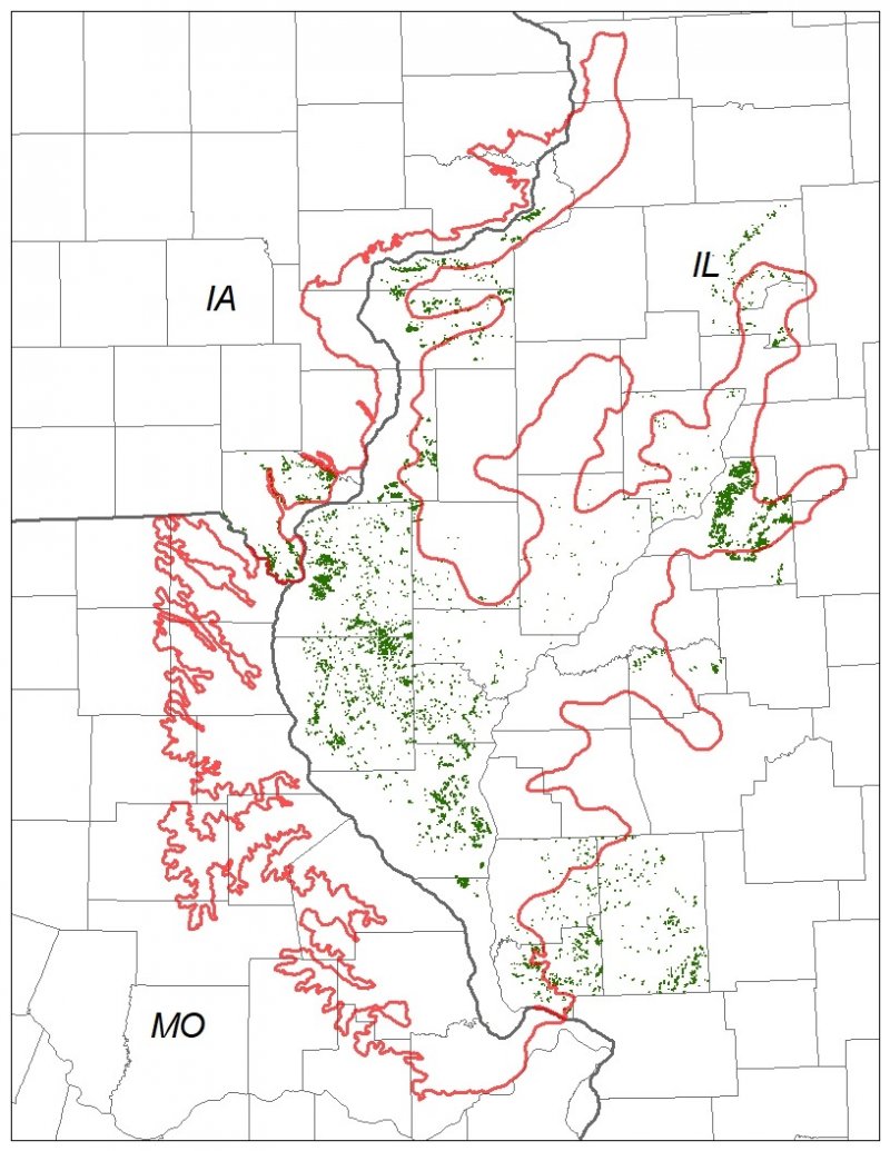
The Central Mississippi Valley Wooded Slopes, Northern part (Land Resource Unit (LRU) (115XC) encompasses the Wyaconda River Dissected Till Plains, Mississippi River Hills, and Mississippi River Alluvial Plain (Schwegman et al. 1973; Nelson 2010). It spans three states – Illinois (73 percent), Iowa (6 percent), and Missouri (21 percent) – comprising about 13,650 square miles (Figure 1). The elevation ranges from 420 feet above sea level (ASL) along the Mississippi River floodplains to 885 feet on the upland ridges. Local relief varies from 10 to 20 feet but can be as high as 50 to 100 feet along drainageways and streams and the bluffs on the major rivers reaching 250 feet above valley floors. Wisconsin-aged loess covers the uplands, while Illinoian glacial drift lies directly below. The loess and drift deposits are underlain by several bedrock systems, including the Cretaceous, Pennsylvania, Mississippian, Silurian, Devonian, and Ordovician Systems. Wisconsin outwash deposits and sandy eolian material occur along stream terraces of major tributaries (USDA-NRCS 2006).
The vegetation across the region has undergone drastic changes over time. At the end of the last glacial episode – the Wisconsinan glaciation – the evolution of vegetation began with the development of tundra habitats, followed by a phase of spruce and fir forests, and eventually spruce-pine forests. Not until approximately 9,000 years ago did the climate undergo a warming trend which prompted the development of deciduous forests dominated by oak and hickory. As the climate continued to warm and dry, prairies began to develop approximately 8,300 years ago. Another shift in climate that resulted in an increase in moisture prompted the emergence of savanna-like habitats from 8,000 to 5,000 years before present (Taft et al. 2009). During the most recent climatic shifts, forested ecosystems maintained footholds on steep valley sides and wet floodplains. Due to the physiography of the MLRA, forests were the dominant ecosystems and were affected by such natural disturbances as droughts, wind, lightning, and occasional fire (Taft et al. 2009).
Classification relationships
Major Land Resource Area (MLRA) (USDA-NRCS, 2022):
115X–Central Mississippi Valley Wooded Slopes
USFS Subregions: Central Dissected Till Plains (251C)Section; Western Mississippi River Hills (251Ce), Mississippi River and Illinois Alluvial Plains (251Cf), Eastern Mississippi River Hills (251Ci), Galesburg Dissected Till Plain (251Cj), and Wyaconda River Dissected Till Plain (251Cm) Subsections (Cleland et al. 2007)
U.S. EPA Level IV Ecoregion: Upper Mississippi River Alluvial Plain (72d), River Hills (72f), and Western Dissected Illinoian Till Plain (72i) (USEPA 2013)
National Vegetation Classification – Ecological Systems: North-Central Interior Wet Flatwoods (CES202.700) (NatureServe 2018)
National Vegetation Classification – Plant Associations: Quercus stellata/Cinna arundinacea Flatwoods (CEGL002405) (Nature Serve 2018)
Biophysical Settings: North-Central Interior Wet Flatwoods (BpS 4315180) (LANDFIRE 2009)
Natural Resources Conservation Service – Iowa Plant Community Species List: Forest, Pin Oak Mixed Hardwood (USDA-NRCS 2007)
Illinois Natural Areas Inventory: Southern Flatwoods (White and Madany 1978)
Iowa Department of Natural Resources: Upland Forest (INAI 1984)
Missouri Terrestrial Natural Communities: Upland Flatwoods (Nelson 2010)
Ecological site concept
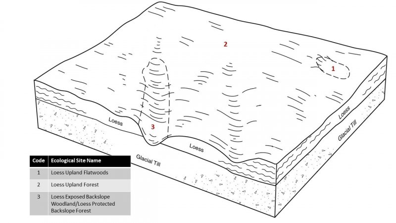
Loess Upland Flatwoods are located within the green areas on the map. They occur on upland flats. The soils are Alfisols that are poorly drained and very deep, formed in loess. Low hydraulic gradients create a shallow depth to a perched water table.
The historic pre-European settlement vegetation on this ecological site was dominated by an open oak woodland community. Post oak (Quercus stellata Wangenh.) is the dominant overstory species and little bluestem (Schizachyrium scoparium (Michx.) Nash) and sweet woodreed (Cinna arundinacea L.) are the dominant and characteristic herbaceous species on the site, respectively. Other canopy associates likely include white oak (Quercus alba L.), swamp white oak (Quercus bicolor Willd.), blackjack oak (Quercus marilandica Münchh.), and pin oak (Quercus palustris Münchh.) (White and Madany 1978; NatureServe 2018). Seasonal high-water tables, windthrow, periodic fires, and drought are important disturbances that maintain this ecological site (LANDFIRE 2009).
Associated sites
| F115XC005IL |
Loess Upland Forest Loess and loess-covered substrate parent material that is not shallow to a high-water table including Atlas, Baylis, Bunkum, Caseyville, Creal, Derinda, Dodge, Fayette, Fishhook, Hickory, Kendall, Keomah, Keswick, Menfro, Metea, Navlys, Rozetta, Seaton, Stookey, Stronghurst, Sylvan, Thebes, Timula, Ursa, and Winfield soils |
|---|
Table 1. Dominant plant species
| Tree |
(1) Quercus stellata |
|---|---|
| Shrub |
Not specified |
| Herbaceous |
(1) Schizachyrium scoparium |
Click on box and path labels to scroll to the respective text.
| T1A | - | Cultural treatments are implemented to increase forage quality and yield. |
|---|---|---|
| T1B | - | Ag conversion via tillage, seeding and non-selective herbicide. |
| T2A | - | Ag conversion via tillage, seeding and non-selective herbicide. |
| R2A | - | Site preparation; tree planting; non-native species control; native seeding. |
| T3A | - | Cultural treatments are implemented to increase forage quality and yield. |
| R3A | - | Site preparation; tree planting; non-native species control; native seeding. |
| T4A | - | Cultural treatments are implemented to increase forage quality and yield. |
| T4B | - | Ag conversion via tillage, seeding and non-selective herbicide. |
State 1 submodel, plant communities
| 1.1A | - | Natural succession following no disturbance for 30-50 years |
|---|---|---|
| 1.2A | - | Fire or other disturbance event |
State 2 submodel, plant communities
| 2.1A | - | Livestock grazing; proper animal to forage balance |
|---|---|---|
| 2.1B | - | Livestock grazing with overutilization of the forage plants. |
| 2.2A | - | Mechanical harvest |
| 2.2B | - | Grazing; overutilization of forage species |
| 2.3B | - | Mechanical harvest |
| 2.3A | - | Grazing with proper forage to animal balance |
State 3 submodel, plant communities
| 3.1A | - | Less tillage; residue management |
|---|---|---|
| 3.1B | - | Less tillage; residue mgmt.; cover crops |
| 3.2A | - | intensive tillage; remove residue; row cropping |
| 3.2B | - | Implement cover crops |
| 3.3B | - | Intensive tillage; remove residue; row cropping |
| 3.3A | - | Absence of cover crops |
State 4 submodel, plant communities
| 4.1A | - | Successful stand improvement practices |
|---|---|---|
| 4.2A | - | Setback in restoration |


