Natural Resources
Conservation Service
Ecological site F116BY009MO
Chert Protected Backslope Forest
Last updated: 10/06/2020
Accessed: 03/23/2026
General information
Provisional. A provisional ecological site description has undergone quality control and quality assurance review. It contains a working state and transition model and enough information to identify the ecological site.
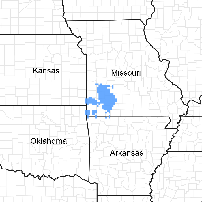
Figure 1. Mapped extent
Areas shown in blue indicate the maximum mapped extent of this ecological site. Other ecological sites likely occur within the highlighted areas. It is also possible for this ecological site to occur outside of highlighted areas if detailed soil survey has not been completed or recently updated.
MLRA notes
Major Land Resource Area (MLRA): 116B–Springfield Plain
The Springfield Plain is in the western part of the Ozark Uplift. It is primarily a smooth plateau with some dissection along streams. Elevation is about 1,000 feet in the north to over 1,700 feet in the east along the Burlington Escarpment adjacent to the Ozark Highlands. The underlying bedrock is mainly Mississippian-aged limestone, with areas of shale on lower slopes and structural benches, and intermittent Pennsylvanian-aged sandstone deposits on the plateau surface.
Classification relationships
Terrestrial Natural Community Type in Missouri (Nelson, 2010):
The reference state for this ecological site is most similar to a Dry-Mesic Chert Forest.
Missouri Department of Conservation Forest and Woodland Communities (Missouri Department of Conservation, 2006):
The reference state for this ecological site is most similar to White Oak Forest.
National Vegetation Classification System Vegetation Association (NatureServe, 2010):
The reference state for this ecological site is most similar to a Quercus alba / Cornus florida Unglaciated Forest (CEGL002066).
Geographic relationship to the Missouri Ecological Classification System (Nigh & Schroeder, 2002):
This ecological site occurs primarily within the following Land Type Associations:
Spring River Prairie/Savanna Dissected Plain
Upper Sac River Oak Savanna/Woodland Low Hills
Little Sac River oak Savanna/Woodland Low Hills
James River Oak Savanna/Woodland Low Hills
Finley River Oak Savanna/Woodland Low Hills
Ecological site concept
NOTE: This is a “provisional” Ecological Site Description (ESD) that is under development. It contains basic ecological information that can be used for conservation planning, application and land management. After additional information is collected, analyzed and reviewed, this ESD will be refined and published as “Approved”.
Chert Protected Backslope Forests occur on steep backslopes with northern and eastern aspects that are associated with the major stream valleys of the region, such as the Sac river valley and the upper reaches of the James River and Finley Creek. They also occur in valleys along the southern edge of the Springfield Plain, where soils are formed in the lower Mississippian limestones and into the Ordovician-aged Jefferson City Cotter formation. This site is mapped in complex with the Chert Exposed Backslope Woodland ecological site. Soils are typically very deep, with an abundance of chert fragments. The reference plant community is forest with an overstory dominated by white oak, an understory dominated by flowering dogwood and blackgum, and a rich herbaceous ground flora.
Associated sites
| F116BY017MO |
Gravelly/Loamy Upland Drainageway Woodland Gravelly/Loamy Upland Drainageway Woodlands are downslope. |
|---|---|
| F116BY003MO |
Chert Upland Woodland Chert Upland Woodlands are upslope, on upper backslopes. |
| F116BY004MO |
Low-Base Chert Upland Woodland Low-base Chert Upland Woodlands are upslope, on convex summit crests, and often contain a fragipan in the subsoil. |
| F116BY013MO |
Loamy Footslope Woodland Loamy Footslope Woodlands are downslope. |
| F116BY032MO |
Chert Exposed Backslope Woodland Chert Exposed Backslope Woodlands are mapped in complex with this ecological site, on steep southern and western aspects. |
| R116BY024MO |
Shallow Limestone Upland Glade/Woodland Shallow Limestone Upland Glade/Woodlands are often downslope. |
| F116BY001MO |
Fragipan Upland Woodland Fragipan Upland Woodlands are upslope on convex summits where a thin layer of loess is present over a fragipan in the subsoil. |
Similar sites
| F116BY032MO |
Chert Exposed Backslope Woodland Chert Exposed Backslope Woodlands are mapped in complex with this ecological site, on steep southern and western aspects. Chert Exposed Backslope Woodlands are less productive and more open. |
|---|
Table 1. Dominant plant species
| Tree |
(1) Quercus alba |
|---|---|
| Shrub |
(1) Cornus florida |
| Herbaceous |
(1) Aristolochia serpentaria |
Physiographic features
This site is on upland backslopes with slopes of 15 to 50 percent. It is on protected aspects (north, northeast, and east), which receive significantly less solar radiation than the exposed aspects. The site receives runoff from upslope summit and shoulder sites, and generates runoff to adjacent, downslope ecological sites. This site does not flood.
The adjacent figure (adapted from Hughes, 1982) shows the typical landscape position of this ecological site, and landscape relationships with other ecological sites. Chert Protected Backslope Forest sites are within the area labeled “3”, on lower backslopes with northerly to easterly exposures. Chert Exposed Backslope Woodland sites are on the corresponding southerly to westerly exposures. Upper slopes and shoulders within the area are in the Chert Upland Woodland ecological site. Low-base Chert Upland Woodland sites, labeled “2”, are often upslope on crests and shoulders.
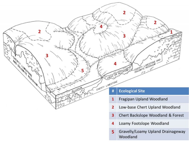
Figure 2. Landscape relationships for this ecological site.
Table 2. Representative physiographic features
| Landforms |
(1)
Hill
(2) Hillslope |
|---|---|
| Flooding frequency | None |
| Ponding frequency | None |
| Slope | 15 – 50% |
| Water table depth | 60 in |
| Aspect | N, NE, E |
Climatic features
The Ozark Highland has a continental type of climate marked by strong seasonality. In winter, dry-cold air masses, unchallenged by any topographic barriers, periodically swing south from the northern plains and Canada. If they invade reasonably humid air, snowfall and rainfall result. In summer, moist, warm air masses, equally unchallenged by topographic barriers, swing north from the Gulf of Mexico and can produce abundant amounts of rain, either by fronts or by convectional processes. In some summers, high pressure stagnates over the region, creating extended droughty periods. Spring and fall are transitional seasons when abrupt changes in temperature and precipitation may occur due to successive, fast-moving fronts separating contrasting air masses.
The Ozark Highland experiences regional differences in climates, but these differences do not have obvious geographic boundaries. Regional climates grade inconspicuously into each other. The basic gradient for most climatic characteristics is along a line crossing the MLRA from northwest to southeast.
The average annual precipitation in almost all of this area is 38 to 45 inches. Snow falls nearly every winter, but the snow cover lasts for only a few days. The average annual temperature is about 53 to 60 degrees F. The lower temperatures occur at the higher elevations in the western part of the MLRA. Mean January minimum temperature follows a stronger north-to-south gradient. However, mean July maximum temperature shows hardly any geographic variation in the MLRA. Mean July maximum temperatures have a range of only two or three degrees across the area.
Mean annual precipitation varies along a northwest to southeast gradient. Seasonal climatic variations are more complex. Seasonality in precipitation is very pronounced due to strong continental influences. June precipitation, for example, averages three to four times greater than January precipitation. Most of the rainfall occurs as high-intensity, convective thunderstorms in summer.
During years when precipitation comes in a fairly normal manner, moisture is stored in the top layers of the soil during the winter and early spring, when evaporation and transpiration are low. During the summer months the loss of water by evaporation and transpiration is high, and if rainfall fails to occur at frequent intervals, drought will result. Drought directly affects plant and animal life by limiting water supplies, especially at times of high temperatures and high evaporation rates.
Superimposed upon the basic MLRA climatic patterns are local topographic influences that create topoclimatic, or microclimatic variations. In regions of appreciable relief, for example, air drainage at nighttime may produce temperatures several degrees lower in valley bottoms than on side slopes. At critical times during the year, this phenomenon may produce later spring or earlier fall freezes in valley bottoms. Deep sinkholes often have a microclimate significantly cooler, moister, and shadier than surrounding surfaces, a phenomenon that may result in a strikingly different ecology. Higher daytime temperatures of bare rock surfaces and higher reflectivity of these unvegetated surfaces may create distinctive environmental niches such as glades and cliffs.
Slope orientation is an important topographic influence on climate. Summits and south-and-west-facing slopes are regularly warmer and drier than adjacent north- and-east-facing slopes. Finally, the climate within a canopied forest is measurably different from the climate of a more open grassland or savanna areas.
Source: University of Missouri Climate Center - http://climate.missouri.edu/climate.php; Land Resource Regions and Major Land Resource Areas of the United States, the Caribbean, and the Pacific Basin, United States Department of Agriculture Handbook 296 - http://soils.usda.gov/survey/geography/mlra/
Table 3. Representative climatic features
| Frost-free period (characteristic range) | 154-162 days |
|---|---|
| Freeze-free period (characteristic range) | 186-195 days |
| Precipitation total (characteristic range) | 45-46 in |
| Frost-free period (actual range) | 146-162 days |
| Freeze-free period (actual range) | 182-197 days |
| Precipitation total (actual range) | 45-46 in |
| Frost-free period (average) | 157 days |
| Freeze-free period (average) | 190 days |
| Precipitation total (average) | 46 in |
Figure 3. Monthly precipitation range
Figure 4. Monthly minimum temperature range
Figure 5. Monthly maximum temperature range
Figure 6. Monthly average minimum and maximum temperature
Figure 7. Annual precipitation pattern
Figure 8. Annual average temperature pattern
Climate stations used
-
(1) CARTHAGE [USC00231356], Carthage, MO
-
(2) MT VERNON M U SW CTR [USC00235862], Mount Vernon, MO
-
(3) SPRINGFIELD [USW00013995], Springfield, MO
-
(4) STOCKTON DAM [USC00238082], Stockton, MO
Influencing water features
This ecological site is not influenced by wetland or riparian water features. This site generates runoff to adjacent, downslope ecological sites. This site does not flood.
The water features of this upland ecological site include evapotranspiration, surface runoff, and drainage. Each water balance component fluctuates to varying extents from year-to-year. Evapotranspiration remains the most constant. Precipitation and drainage are highly variable between years. Seasonal variability differs for each water component. Precipitation generally occurs as single day events. Evapotranspiration is lowest in the winter and peaks in the summer. Water stored as ice and snow decreases drainage and surface runoff rates throughout the winter and increases these fluxes in the spring. The surface runoff pulse is greatly influenced by extreme events. Conversion to cropland or other high intensities land uses tends to increase runoff, but also decreases evapotranspiration. Depending on the situation, this might increase groundwater discharge, and decrease baseflow in receiving
streams.
Soil features
These soils have no rooting restriction, and subsoils are not low in bases. The soils were formed under woodland vegetation, and have thin, light-colored surface horizons. Parent material is slope alluvium over residuum weathered primarily from limestone. They have very gravelly or very cobbly silt loam surface horizons, and skeletal subsoils with high amounts of chert gravel and cobbles. They are not affected by seasonal wetness. Soil series associated with this site include Goss and Rueter.
The accompanying picture of the Goss series shows a thin, light-colored surface horizon underlain by very cobbly reddish clay. Scale is in inches. Picture from Henderson (2004).
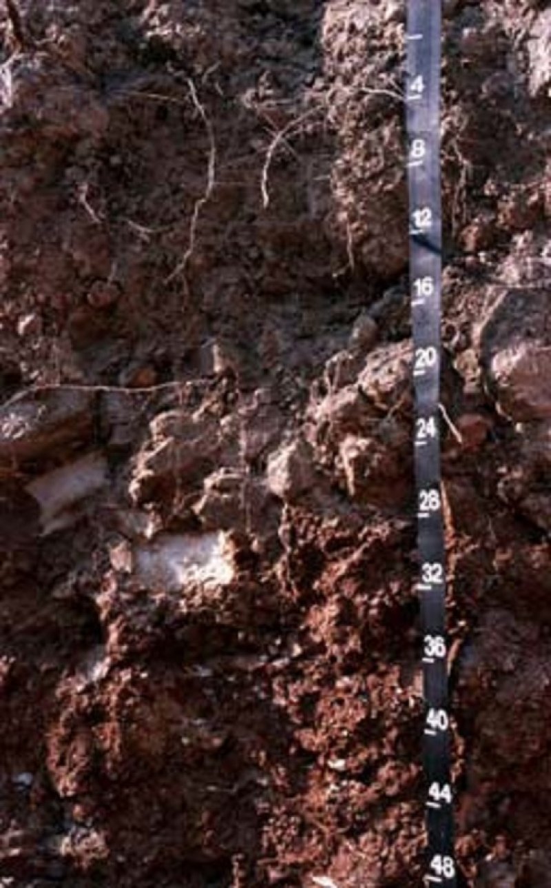
Figure 9. Goss series
Table 4. Representative soil features
| Parent material |
(1)
Residuum
–
cherty limestone
(2) Slope alluvium |
|---|---|
| Surface texture |
(1) Very gravelly silt loam (2) Very cobbly silt loam (3) Extremely gravelly silt loam |
| Family particle size |
(1) Clayey |
| Drainage class | Well drained to somewhat excessively drained |
| Permeability class | Moderately slow |
| Soil depth | 72 in |
| Surface fragment cover <=3" | 20 – 75% |
| Surface fragment cover >3" | 25% |
| Available water capacity (0-40in) |
1 – 5 in |
| Calcium carbonate equivalent (0-40in) |
Not specified |
| Electrical conductivity (0-40in) |
2 mmhos/cm |
| Sodium adsorption ratio (0-40in) |
Not specified |
| Soil reaction (1:1 water) (0-40in) |
4.5 – 7.3 |
| Subsurface fragment volume <=3" (Depth not specified) |
30 – 70% |
| Subsurface fragment volume >3" (Depth not specified) |
16 – 30% |
Ecological dynamics
Information contained in this section was developed using historical data, professional experience, field reviews, and scientific studies. The information presented is representative of very complex vegetation communities. Key indicator plants, animals and ecological processes are described to help inform land management decisions. Plant communities will differ across the MLRA because of the naturally occurring variability in weather, soils, and aspect. The Reference Plant Community is not necessarily the management goal. The species lists are representative and are not botanical descriptions of all species occurring, or potentially occurring, on this site. They are not intended to cover every situation or the full range of conditions, species, and responses for the site.
Chert Protected Backslope Forests occur in the most protected landscape positions on lower, steep slopes in the deeper valleys furthest from the prairie uplands. The historic reference community for Chert Protected Backslope Forests has a well-developed forest canopy (80-100 feet tall and 90-100 percent canopy closure) and subcanopy dominated by white oak, a structurally diverse understory and an abundant forest ground flora. While the upland prairies and savannas had an estimated fire frequency of 1-3 years, Chert Protected Backslope Forests burned less frequently (estimated 5-20 years) and with lower intensity.
The composition and structure of the Chert Backslopes varies in relation to slope aspect. Exposed, south and west facing slopes are doughtier and more fire-prone than are the protected north and east facing slopes, which are relatively cool and moist. These two ecological sites intergrade on neutral, northwest and southeast exposures.
Historically, grazing by native large herbivores, such as bison, elk, and white-tailed deer, and periodic fires kept understory conditions more open. In addition, these ecological types were subject to occasional disturbances from wind and ice, which opened the canopy up by knocking over trees or breaking substantial branches of canopy trees.
Today, these communities have been cleared and converted to pasture, or have undergone repeated timber harvest and domestic grazing. Most existing occurrences have a younger (50-80 years) canopy layer whose composition has been altered by timber harvesting practices. An increase in hickories over historic conditions is common. In addition, in the absence of fire, the canopy, sub-canopy and woody understory layers are better developed. The absence of periodic fire has allowed more shade-tolerant tree species, such as sugar maple, white ash, or hickory to increase in abundance.
Uncontrolled domestic grazing has diminished the diversity and cover of woodland ground flora species, and has introduced weedy species such as gooseberry, coralberry, poison ivy and Virginia creeper created a more open understory and increased soil compaction.
Chert Protective Backslope Forests are some of the most productive timber sites in the Springfield Plain. Carefully planned single tree selection or the creation of small group openings can help regenerate more desirable oak species and increase vigor on the residual trees. Clear-cutting does occur and results in dense, even-aged stands of primarily oak. This may be most beneficial for existing stands whose composition has been highly altered by past management practices. However, without some thinning of the dense stands, the ground flora diversity can be shaded out and productivity of the stand may suffer.
Prescribed fire can play a beneficial but limited role in the management of this ecological site. The higher productivity of these sites makes it more challenging than on other forest sites in the region. Protected aspect forests did evolve with some fire, but their composition often reflects more closed, forested conditions, with fewer woodland ground flora species that can respond to fire.
Consequently, while having protected aspects in a burn unit is acceptable, targeting them solely for woodland restoration is not advisable.
A State and Transition Diagram follows. Detailed descriptions of each state, transition, plant community, and pathway follow the model. This model is based on available experimental research, field observations, professional consensus, and interpretations. It is likely to change as knowledge increases.
State and transition model
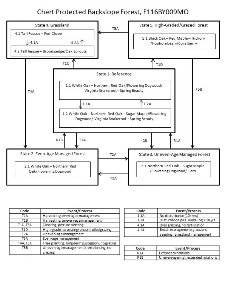
Figure 10. State and transition diagram for this ecological site
More interactive model formats are also available.
View Interactive Models
More interactive model formats are also available.
View Interactive Models
Click on state and transition labels to scroll to the respective text
Ecosystem states
States 1 and 5 (additional transitions)
State 1 submodel, plant communities
State 2 submodel, plant communities
State 3 submodel, plant communities
State 4 submodel, plant communities
State 5 submodel, plant communities
State 1
Reference
The reference state was dominated by white oak. Periodic disturbances from fire, wind or ice maintained the dominance of white oak by opening up the canopy and allowing more light for white oak reproduction. Long disturbance-free periods allowed an increase in more shade tolerant species such as northern red oak and sugar maple. Two community phases are recognized in this state, with shifts between phases based on disturbance frequency. This reference state is uncommon today. Some sites have been converted to grassland (State 4). Others have been subject to repeated, high-graded timber harvest coupled with domestic livestock grazing (State 5). Fire suppression has resulted in increased canopy density, which has affected the abundance and diversity of ground flora. Many reference sites have been managed for timber harvest, resulting in either even-age (State 2) or uneven-age (State 3) forests.
Community 1.1
White Oak – Northern Red Oak/Flowering Dogwood/ Virginia Snakeroot – Spring Beauty
This community is one of the more productive upland forests in the MLRA. While the overstory is dominated by white oak, northern red oak and blackgum can also be common. This forest community has a multi-tiered structure, and a canopy that is 75 to 100 feet tall with 80 to 100 percent closure. The sub-canopy and understory are well developed, with flowering dogwood as a dominant understory tree and sapling. A moderate abundance of shade tolerant forest generalists, such as Mayapple, Christmas fern, ticktrefoil and white snakeroot, cover the ground. Periodic disturbances, including fire, ice and wind create canopy gaps, allowing white oak to successfully reproduce and enter the canopy. In the absence of disturbance, more shade tolerant species such as northern red oak, sugar maple, hickory, white ash and others increase in importance and add structural diversity to the system. In addition, more shade-loving forest shrub (e.g., northern spicebush) and herbaceous (e.g., bloodroot) species also increase. Over time, these gradual species changes result in a transition to community phase 1.2.
Forest overstory. The Overstory Species list is based on field reconnaissance as well as commonly occurring species listed in Nelson 2010; names and symbols are from USDA PLANTS database.
Forest understory. The Understory Species list is based on field reconnaissance as well as commonly occurring species listed in Nelson 2010; names and symbols are from USDA PLANTS database.
Community 1.2
White Oak – Northern Red Oak – Sugar Maple/Flowering Dogwood/ Virginia Snakeroot – Spring Beauty
The overstory is a mixture of white oak and more shade tolerant species such as northern red oak, sugar maple, hickory, white ash and others. This forest community has a multi-tiered structure, and a canopy that is 75 to 100 feet tall with 90 to 100 percent closure. An abundance of shade tolerant forest generalists, such as Mayapple, Christmas fern, ticktrefoil and white snakeroot, cover the ground. In addition, more shade-loving forest shrub (e.g., northern spicebush) and herbaceous (e.g., bloodroot) species are common. Periodic disturbances, including fire, ice and wind create canopy gaps, allowing white oak to successfully reproduce and enter the canopy. Over time, these disturbance events result in a community phase transition back to phase 1.1..
Pathway 1.1A
Community 1.1 to 1.2
This pathway is a gradual transition that results from extended, disturbance-free periods of roughly 20 years or longer.
Pathway 1.2A
Community 1.2 to 1.1
This pathway results from ecological disturbances such as fire, ice storms, or violent wind storms. Historically, native grazers such as bison provided disturbance events as well.
State 2
Even-Age Managed Forest
These forests tend to be rather dense, with an under developed understory and ground flora. Thinning can increase overall tree vigor and improve understory diversity. Continual timber management, depending on the practices used, will either maintain this state, or convert the site to uneven-age (State 3) forests.
Dominant resource concerns
-
Plant structure and composition
-
Terrestrial habitat for wildlife and invertebrates
Community 2.1
White Oak-Red Oak/Flowering Dogwood
State 3
Uneven-Age Managed Forest
Uneven-Age Managed forests resemble the reference state. The biggest difference is tree age, most being only 50 to 90 years old. Composition is also likely altered from the reference state depending on tree selection during harvest. In addition, without a regular 15 to 20 year harvest re-entry into these stands, they will slowly increase in more shade tolerant species such as sugar maple and white oak will become less dominant.
Dominant resource concerns
-
Plant structure and composition
-
Wildfire hazard from biomass accumulation
-
Terrestrial habitat for wildlife and invertebrates
Community 3.1
Red Oak-Maple/Flowering Dogwood/Fern
State 4
Grassland
Type conversion of forests to planted, non-native pasture species such as tall fescue has been common in this MLRA. Steep slopes, abundant surface fragments, low organic matter contents and soil acidity make non-native pastures challenging to maintain in a healthy, productive state on this ecological site. If grazing and active pasture management is discontinued, the site will eventually transition to State 2 (Even-Age).
Community 4.1
Tall Fescue - Red Clover
Dominant resource concerns
-
Plant structure and composition
-
Terrestrial habitat for wildlife and invertebrates
Community 4.2
Tall Fescue - Broomsedge/Oak Sprouts
Dominant resource concerns
-
Sheet and rill erosion
-
Ephemeral gully erosion
-
Compaction
-
Plant productivity and health
-
Plant structure and composition
-
Plant pest pressure
-
Terrestrial habitat for wildlife and invertebrates
-
Feed and forage imbalance
Pathway P4.1A
Community 4.1 to 4.2
Over grazing; no fertilization
Pathway P4.2A
Community 4.2 to 4.1
Brush management; grassland seeding; grassland management
State 5
High Graded/Grazed Forest
Forested sites subjected to repeated, high-graded timber harvests and uncontrolled domestic grazing transition to this State. This state exhibits an over-abundance of hickory and other less desirable tree species, and weedy understory species such as buckbrush, gooseberry, poison ivy and Virginia creeper. The vegetation offers little nutritional value for cattle, and excessive stocking damages tree boles, degrades understory species composition and results in soil compaction and accelerated erosion and runoff. Exclusion of livestock from sites in this state coupled with uneven-age management techniques will cause a transition to State 3 (Uneven-Age).
Community 5.1
Black Oak - Red Maple - Hickory/Hophornbeam/Coralberry
Transition T1A
State 1 to 2
This transition typically results from even-age timber management practices, such as clear-cut, seed tree or shelterwood harvest.
Transition T1B
State 1 to 3
Harvesting; uneven-age management
Transition T1C
State 1 to 4
Clearing; grassland planting; grassland management
Transition T1D
State 1 to 5
High-grade harvesting; uncontrolled grazing
Restoration pathway R1B
State 2 to 1
This restoration pathway generally requires uneven-age timber management practices with extended rotations that allow mature trees to exceed ages of about 120 years.
Transition T2A
State 2 to 3
This transition typically results from uneven-age timber management practices, such as single tree or group selection harvest.
Restoration pathway R1A
State 3 to 1
This restoration pathway generally requires uneven-age timber management practices, such as single tree or group selection harvest, with extended rotations that allow mature trees to exceed ages of about 120 years.
Transition T3A
State 3 to 2
This transition typically results from even-age timber management practices, such as clear-cut, seed tree or shelterwood harvest.
Transition T4A
State 4 to 2
Tree planting; long-term succession; no grazing
Transition T5B
State 5 to 3
Uneven-age management; tree planting; no grazing
Transition T5A
State 5 to 4
Clearing; grassland planting; grassland management
Additional community tables
Table 5. Community 1.1 forest overstory composition
| Common name | Symbol | Scientific name | Nativity | Height (ft) | Canopy cover (%) | Diameter (in) | Basal area (square ft/acre) |
|---|---|---|---|---|---|---|---|
|
Tree
|
|||||||
| white oak | QUAL | Quercus alba | Native | – | 30–50 | – | – |
| northern red oak | QURU | Quercus rubra | Native | – | 30–50 | – | – |
| shagbark hickory | CAOV2 | Carya ovata | Native | – | 10–20 | – | – |
| red maple | ACRU | Acer rubrum | Native | – | 10–20 | – | – |
| sugar maple | ACSA3 | Acer saccharum | Native | – | 10–20 | – | – |
| blackgum | NYSY | Nyssa sylvatica | Native | – | 10–20 | – | – |
Table 6. Community 1.1 forest understory composition
| Common name | Symbol | Scientific name | Nativity | Height (ft) | Canopy cover (%) | |
|---|---|---|---|---|---|---|
|
Grass/grass-like (Graminoids)
|
||||||
| Muhlenberg's sedge | CAMU4 | Carex muehlenbergii | Native | – | 5–20 | |
| parasol sedge | CAUM4 | Carex umbellata | Native | – | 5–20 | |
| rock muhly | MUSO | Muhlenbergia sobolifera | Native | – | 5–20 | |
| hairy woodland brome | BRPU6 | Bromus pubescens | Native | – | 5–20 | |
| Virginia wildrye | ELVI3 | Elymus virginicus | Native | – | 5–20 | |
| broadleaf rosette grass | DILA8 | Dichanthelium latifolium | Native | – | 5–20 | |
| black edge sedge | CANI3 | Carex nigromarginata | Native | – | 5–20 | |
|
Forb/Herb
|
||||||
| panicledleaf ticktrefoil | DEPA6 | Desmodium paniculatum | Native | – | 5–20 | |
| pointedleaf ticktrefoil | DEGL5 | Desmodium glutinosum | Native | – | 5–20 | |
| perplexed ticktrefoil | DEPE80 | Desmodium perplexum | Native | – | 5–20 | |
| shrubby lespedeza | LEFR5 | Lespedeza frutescens | Native | – | 5–20 | |
| Culver's root | VEVI4 | Veronicastrum virginicum | Native | – | 5–20 | |
| cutleaf toothwort | CACO26 | Cardamine concatenata | Native | – | 5–20 | |
| fourleaf milkweed | ASQU | Asclepias quadrifolia | Native | – | 5–20 | |
| fourleaf yam | DIQU | Dioscorea quaternata | Native | – | 5–20 | |
| Virginia springbeauty | CLVI3 | Claytonia virginica | Native | – | 5–20 | |
| mayapple | POPE | Podophyllum peltatum | Native | – | 5–20 | |
| toadshade | TRSE2 | Trillium sessile | Native | – | 5–20 | |
| wild blue phlox | PHDI5 | Phlox divaricata | Native | – | 5–20 | |
| Virginia snakeroot | ARSE3 | Aristolochia serpentaria | Native | – | 5–20 | |
| largeflower bellwort | UVGR | Uvularia grandiflora | Native | – | 5–20 | |
| white fawnlily | ERAL9 | Erythronium albidum | Native | – | 5–20 | |
| hepatica | HENO2 | Hepatica nobilis | Native | – | 5–20 | |
| goldenseal | HYCA | Hydrastis canadensis | Native | – | 5–20 | |
| feathery false lily of the valley | MARA7 | Maianthemum racemosum | Native | – | 5–20 | |
| nakedflower ticktrefoil | DENU4 | Desmodium nudiflorum | Native | – | 5–10 | |
| lesser yellow lady's slipper | CYPAP4 | Cypripedium parviflorum var. parviflorum | Native | – | 0–5 | |
|
Fern/fern ally
|
||||||
| Christmas fern | POAC4 | Polystichum acrostichoides | Native | – | 5–20 | |
| rattlesnake fern | BOVI | Botrychium virginianum | Native | – | 5–20 | |
|
Shrub/Subshrub
|
||||||
| Blue Ridge blueberry | VAPA4 | Vaccinium pallidum | Native | – | 10–30 | |
| common serviceberry | AMAR3 | Amelanchier arborea | Native | – | 10–20 | |
| fragrant sumac | RHAR4 | Rhus aromatica | Native | – | 10–20 | |
|
Tree
|
||||||
| flowering dogwood | COFL2 | Cornus florida | Native | – | 20–30 | |
| common serviceberry | AMAR3 | Amelanchier arborea | Native | – | 10–20 | |
| hophornbeam | OSVI | Ostrya virginiana | Native | – | 10–20 | |
| cat greenbrier | SMGL | Smilax glauca | Native | – | 10–20 | |
|
Vine/Liana
|
||||||
| Virginia creeper | PAQU2 | Parthenocissus quinquefolia | Native | – | 10–20 | |
| cat greenbrier | SMGL | Smilax glauca | Native | – | 10–20 | |
| summer grape | VIAE | Vitis aestivalis | Native | – | 10–20 | |
Table 7. Community 1.2 forest overstory composition
| Common name | Symbol | Scientific name | Nativity | Height (ft) | Canopy cover (%) | Diameter (in) | Basal area (square ft/acre) |
|---|---|---|---|---|---|---|---|
|
Tree
|
|||||||
| white oak | QUAL | Quercus alba | Native | – | 30–50 | – | – |
| northern red oak | QURU | Quercus rubra | Native | – | 30–50 | – | – |
| white ash | FRAM2 | Fraxinus americana | Native | – | 10–20 | – | – |
| red maple | ACRU | Acer rubrum | Native | – | 5–20 | – | – |
| sugar maple | ACSA3 | Acer saccharum | Native | – | 5–20 | – | – |
| shortleaf pine | PIEC2 | Pinus echinata | Native | – | 0–5 | – | – |
Table 8. Community 1.2 forest understory composition
| Common name | Symbol | Scientific name | Nativity | Height (ft) | Canopy cover (%) | |
|---|---|---|---|---|---|---|
|
Forb/Herb
|
||||||
| Virginia springbeauty | CLVI3 | Claytonia virginica | Native | – | 20–40 | |
| wild blue phlox | PHDI5 | Phlox divaricata | Native | – | 20–30 | |
| mayapple | POPE | Podophyllum peltatum | Native | – | 20–30 | |
| toadshade | TRSE2 | Trillium sessile | Native | – | 20–30 | |
| largeflower bellwort | UVGR | Uvularia grandiflora | Native | – | 10–20 | |
| white fawnlily | ERAL9 | Erythronium albidum | Native | – | 10–20 | |
| hepatica | HENO2 | Hepatica nobilis | Native | – | 10–20 | |
| goldenseal | HYCA | Hydrastis canadensis | Native | – | 10–20 | |
| feathery false lily of the valley | MARA7 | Maianthemum racemosum | Native | – | 10–20 | |
| Virginia snakeroot | ARSE3 | Aristolochia serpentaria | Native | – | 10–20 | |
| lesser yellow lady's slipper | CYPAP4 | Cypripedium parviflorum var. parviflorum | Native | – | 0–5 | |
|
Fern/fern ally
|
||||||
| rattlesnake fern | BOVI | Botrychium virginianum | Native | – | 5–20 | |
| Christmas fern | POAC4 | Polystichum acrostichoides | Native | – | 5–20 | |
|
Shrub/Subshrub
|
||||||
| common serviceberry | AMAR3 | Amelanchier arborea | Native | – | 10–20 | |
| fragrant sumac | RHAR4 | Rhus aromatica | Native | – | 10–20 | |
| Blue Ridge blueberry | VAPA4 | Vaccinium pallidum | Native | – | 10–20 | |
|
Tree
|
||||||
| flowering dogwood | COFL2 | Cornus florida | Native | – | 20–30 | |
| blackgum | NYSY | Nyssa sylvatica | Native | – | 10–20 | |
| hophornbeam | OSVI | Ostrya virginiana | Native | – | 10–20 | |
|
Vine/Liana
|
||||||
| Virginia creeper | PAQU2 | Parthenocissus quinquefolia | Native | – | 10–20 | |
| cat greenbrier | SMGL | Smilax glauca | Native | – | 10–20 | |
Table 9. Community 2.1 forest overstory composition
| Common name | Symbol | Scientific name | Nativity | Height (ft) | Canopy cover (%) | Diameter (in) | Basal area (square ft/acre) |
|---|---|---|---|---|---|---|---|
|
Tree
|
|||||||
| white oak | QUAL | Quercus alba | Native | – | 80–100 | – | – |
| northern red oak | QURU | Quercus rubra | Native | – | 10–20 | – | – |
| white ash | FRAM2 | Fraxinus americana | Native | – | 0–5 | – | – |
Table 10. Community 2.1 forest understory composition
| Common name | Symbol | Scientific name | Nativity | Height (ft) | Canopy cover (%) | |
|---|---|---|---|---|---|---|
|
Forb/Herb
|
||||||
| mayapple | POPE | Podophyllum peltatum | Native | – | 5–10 | |
| Virginia springbeauty | CLVI3 | Claytonia virginica | Native | – | 5–10 | |
| wild blue phlox | PHDI5 | Phlox divaricata | Native | – | 5–10 | |
|
Fern/fern ally
|
||||||
| Christmas fern | POAC4 | Polystichum acrostichoides | Native | – | 5–10 | |
|
Shrub/Subshrub
|
||||||
| common serviceberry | AMAR3 | Amelanchier arborea | Native | – | 5–10 | |
|
Tree
|
||||||
| flowering dogwood | COFL2 | Cornus florida | Native | – | 5–10 | |
|
Vine/Liana
|
||||||
| Virginia creeper | PAQU2 | Parthenocissus quinquefolia | Native | – | 5–10 | |
Table 11. Community 4.1 forest overstory composition
| Common name | Symbol | Scientific name | Nativity | Height (ft) | Canopy cover (%) | Diameter (in) | Basal area (square ft/acre) |
|---|---|---|---|---|---|---|---|
|
Tree
|
|||||||
| white oak | QUAL | Quercus alba | Native | – | 50–90 | – | – |
| northern red oak | QURU | Quercus rubra | Native | – | 5–30 | – | – |
| black oak | QUVE | Quercus velutina | Native | – | 5–20 | – | – |
| shortleaf pine | PIEC2 | Pinus echinata | Native | – | 0–20 | – | – |
| shagbark hickory | CAOV2 | Carya ovata | Native | – | 5–10 | – | – |
Table 12. Community 5.1 forest overstory composition
| Common name | Symbol | Scientific name | Nativity | Height (ft) | Canopy cover (%) | Diameter (in) | Basal area (square ft/acre) |
|---|---|---|---|---|---|---|---|
|
Tree
|
|||||||
| white oak | QUAL | Quercus alba | Native | – | 0–5 | – | – |
| eastern redcedar | JUVI | Juniperus virginiana | Native | – | 0–5 | – | – |
Table 13. Community 5.1 forest understory composition
| Common name | Symbol | Scientific name | Nativity | Height (ft) | Canopy cover (%) | |
|---|---|---|---|---|---|---|
|
Grass/grass-like (Graminoids)
|
||||||
| broomsedge bluestem | ANVI2 | Andropogon virginicus | Native | – | 0–30 | |
| purpletop tridens | TRFL2 | Tridens flavus | Native | – | 0–10 | |
|
Forb/Herb
|
||||||
| red clover | TRPR2 | Trifolium pratense | Introduced | – | 0–20 | |
| white clover | TRRE3 | Trifolium repens | Introduced | – | 5–20 | |
| sericea lespedeza | LECU | Lespedeza cuneata | Introduced | – | 0–20 | |
Interpretations
Animal community
Wildlife (MDC 2006):
Wild turkey, white-tailed deer, and eastern gray squirrel depend on hard and soft mast food sources and are typical upland game species of this type.
Bird species associated with early-successional community stages are Prairie Warbler, Field Sparrow, Brown Thrasher, Blue-winged Warbler, White-eyed Vireo, Blue-gray Gnatcatcher, Yellow-breasted Chat, Indigo Bunting, and Eastern Towhee.
Birds associated with mid-successional stages include Whip-poor-will and Wood Thrush while birds associated with late-successional stages include Worm-eating warbler, Whip-poor-will, Great Crested Flycatcher, Ovenbird, Pileated Woodpecker, Wood Thrush, Red-eyed Vireo, Northern Parula, Louisiana Waterthrush (near streams), and Broad-winged Hawk.
Reptile and amphibian species associated with mature forests include: ringed salamander, spotted salamander, marbled salamander, central newt, long-tailed salamander, dark-sided salamander, southern red-backed salamander, three-toed box turtle, western worm snake, western earth snake, and American toad.
Other information
Forestry (NRCS 2002; 2014):
Management: Field measured site index values average 64 for white oak and 65 for black oak. Timber management opportunities are good. Create group openings of at least 2 acres. Large clearcuts should be minimized if possible to reduce impacts on wildlife and aesthetics. Uneven-aged management using single tree selection or group selection cuttings of ½ to 1 acre are other options that can be used if clear cutting is not desired or warranted. Using prescribed fire as a management tool could have a negative impact on timber quality, may not be fitting, or should be used with caution on a site if timber management is the primary objective.
Limitations: Large amounts of coarse fragments throughout profile; Surface stones and rocks are problems for efficient and safe equipment operation and will make equipment use somewhat difficult. Disturbing the surface excessively in harvesting operations and building roads increases soil losses, which leaves a greater amount of coarse fragments on the surface. Hand planting or direct seeding may be necessary. Seedling mortality due to low available water capacity may be high. Mulching or providing shade can improve seedling survival. Mechanical tree planting will be limited. Erosion is a hazard when slopes exceed 15 percent. On steep slopes greater than 35 percent, traction problems increase and equipment use is not recommended.
Supporting information
Inventory data references
Potential Reference Sites: Chert Protected Backslope Forest
Plot SPNACA_JK04 – Rueter soil
Located in Springfield Nature Center, Greene County, MO
Latitude: 37.127082
Longitude: -93.244043
Plot TUCRPV03– Rueter soil
Located in Turkey Creek Forest PV, Newton County, MO
Latitude: 37.115028
Longitude: -94.548353
Other references
Anderson, R.C. 1990. The historic role of fire in North American grasslands. Pp. 8-18 in S.L. Collins and L.L. Wallace (eds.). Fire in North American tallgrass prairies. University of Oklahoma Press, Norman.
Batek, M.J., A.J. Rebertus, W.A. Schroeder, T.L. Haithcoat, E. Compas, and R.P. Guyette. 1999. Reconstruction of early nineteenth-century vegetation and fire regimes in the Missouri Ozarks. Journal of Biogeography 26:397-412.
Harlan, J.D., T.A. Nigh and W.A. Schroeder. 2001. The Missouri original General Land Office survey notes project. University of Missouri, Columbia.
Henderson, Richard L. 2004. Soil Survey of Cedar County, Missouri. U.S. Dept. of Agric. Natural Resources Conservation Service.
Hughes, Harold E. 1982. Soil Survey of Greene and Lawrence Counties, Missouri. U.S. Dept. of Agric. Soil Conservation Service.
Ladd, D. 1991. Reexamination of the role of fire in Missouri oak woodlands. Pp. 67-80 in G.V. Brown, James K.; Smith, Jane Kapler, eds. 2000. Wildland fire in ecosystems: effects of fire on flora. Gen. Tech. Rep. RMRS-GTR-42-vol. 2. Ogden, UT: U.S. Department of Agriculture, Forest Service, Rocky Mountain Research Station. 257 p.
Missouri Department of Conservation. 2006. Missouri Forest and Woodland Community Profiles. Missouri Department of Conservation, Jefferson City, Missouri.
NatureServe. 2010. Vegetation Associations of Missouri (revised). NatureServe, St. Paul, Minnesota.
Natural Resources Conservation Service. 2002. Woodland Suitability Groups. Missouri FOTG, Section II, Soil Interpretations and Reports. 30 pgs.
Natural Resources Conservation Service. Site Index Reports. Accessed May 2014. https://esi.sc.egov.usda.gov/ESI_Forestland/pgFSWelcome.aspx
Nelson, Paul W. 2010. The Terrestrial Natural Communities of Missouri. Missouri Department of Conservation, Jefferson City, Missouri.
Nigh, Timothy A., and Walter A. Schroeder. 2002. Atlas of Missouri Ecoregions. Missouri Department of Conservation, Jefferson City, Missouri.
Schoolcraft, H.R. 1821. Journal of a tour into the interior of Missouri and Arkansas from Potosi, or Mine a Burton, in Missouri territory, in a southwest direction, toward the Rocky Mountains: performed in the years 1818 and 1819. Richard Phillips and Company, London.
United States Department of Agriculture – Natural Resource Conservation Service (USDA-NRCS). 2006. Land Resource Regions and Major Land Resource Areas of the United States, the Caribbean, and the Pacific Basin. U.S. Department of Agriculture Handbook 296. 682 pgs.
Contributors
FJY
Fred Young
Doug Wallace
Approval
Nels Barrett, 10/06/2020
Acknowledgments
Missouri Department of Conservation and Missouri Department of Natural Resources personnel provided significant and helpful field and technical support in the development of this ecological site.
Rangeland health reference sheet
Interpreting Indicators of Rangeland Health is a qualitative assessment protocol used to determine ecosystem condition based on benchmark characteristics described in the Reference Sheet. A suite of 17 (or more) indicators are typically considered in an assessment. The ecological site(s) representative of an assessment location must be known prior to applying the protocol and must be verified based on soils and climate. Current plant community cannot be used to identify the ecological site.
| Author(s)/participant(s) | |
|---|---|
| Contact for lead author | |
| Date | 09/16/2020 |
| Approved by | Nels Barrett |
| Approval date | |
| Composition (Indicators 10 and 12) based on | Annual Production |
Indicators
-
Number and extent of rills:
-
Presence of water flow patterns:
-
Number and height of erosional pedestals or terracettes:
-
Bare ground from Ecological Site Description or other studies (rock, litter, lichen, moss, plant canopy are not bare ground):
-
Number of gullies and erosion associated with gullies:
-
Extent of wind scoured, blowouts and/or depositional areas:
-
Amount of litter movement (describe size and distance expected to travel):
-
Soil surface (top few mm) resistance to erosion (stability values are averages - most sites will show a range of values):
-
Soil surface structure and SOM content (include type of structure and A-horizon color and thickness):
-
Effect of community phase composition (relative proportion of different functional groups) and spatial distribution on infiltration and runoff:
-
Presence and thickness of compaction layer (usually none; describe soil profile features which may be mistaken for compaction on this site):
-
Functional/Structural Groups (list in order of descending dominance by above-ground annual-production or live foliar cover using symbols: >>, >, = to indicate much greater than, greater than, and equal to):
Dominant:
Sub-dominant:
Other:
Additional:
-
Amount of plant mortality and decadence (include which functional groups are expected to show mortality or decadence):
-
Average percent litter cover (%) and depth ( in):
-
Expected annual annual-production (this is TOTAL above-ground annual-production, not just forage annual-production):
-
Potential invasive (including noxious) species (native and non-native). List species which BOTH characterize degraded states and have the potential to become a dominant or co-dominant species on the ecological site if their future establishment and growth is not actively controlled by management interventions. Species that become dominant for only one to several years (e.g., short-term response to drought or wildfire) are not invasive plants. Note that unlike other indicators, we are describing what is NOT expected in the reference state for the ecological site:
-
Perennial plant reproductive capability:
Print Options
Sections
Font
Other
The Ecosystem Dynamics Interpretive Tool is an information system framework developed by the USDA-ARS Jornada Experimental Range, USDA Natural Resources Conservation Service, and New Mexico State University.
Click on box and path labels to scroll to the respective text.