Natural Resources
Conservation Service
Ecological site RX142X00B005
Clayplain
Last updated: 5/15/2025
Accessed: 04/10/2026
General information
Provisional. A provisional ecological site description has undergone quality control and quality assurance review. It contains a working state and transition model and enough information to identify the ecological site.
MLRA notes
Major Land Resource Area (MLRA): 142X–St. Lawrence-Champlain Plain
The St. Lawrence-Champlain Plain MLRA is a glaciated area of low relief dominated by broad expanses of nearly level, sandy deltas and shallow lacustrine basins or plains punctuated by low hills of glacial till. Rivers and streams have cut relatively deep but narrow valleys across the plain. Elevation ranges from 80 to 1,000 feet (25 to 305 meters), increasing gradually from the St. Lawrence River southward and from Lake Champlain to the east and west.
LRU notes
Land Resource Unit (LRU): Mesic Soil Temperature Regime
The lower St. Lawrence and Champlain Valleys are characterized with soils in the mesic soil temperature regime (mean annual soil temperature between 46°F and 59°F) at 20 inches below the surface or at a densic, lithic, or paralithic contact, whichever is shallower.
The Mesic Soil Temperature Regime (STR) will have a longer growing season than the upper St. Lawrence and Champlain Valleys which are characterized with soils in the frigid STR. Species more tolerant of milder year round temperatures would also be evident in the mesic LRU.
Classification relationships
USDA-NRCS
LRR: D-Northeastern Forage and Forest Region
MLRA: 142-St. Lawrence-Champlain Plain
LRU: XB - Mesic Soil Temperature Regime
EPA (Ecoregions)
Level III: 83-Eastern Great Lakes Lowlands
Level IV: 83b-Champlain Lowlands
USDA-USFS
Province: Laurentian Mixed Forest
Section: 212E--St. Lawrence and Champlain Valley
Sub-section: 212Ec Champlain Glacial Lake and Marine Plains
Ecological site concept
Landform:
The site occurs on a broad expanse of nearly level to steep glacial lake plains and terraces. The elevation range varies from 49 to 1000 feet (15 to 549 meters) with low local relief generally less than 30 feet (10 meters). Slopes are typically less than or equal to 15 percent but, in extreme cases, can range up to 60 percent.
Soils:
The site consists of very deep and moderately well and somewhat poorly drained soils that are clayey throughout their profile. They formed in calcareous estuarine and glaciolacustrine clays. Representative soils are Vergennes, Wilpoint, Kingsbury, Hudson, Cayuga, Chaumont, Churchville, and Rhinebeck.
Vegetation:
Remnant clayplain forests are scarce, characterized by a mixed forest of deciduous and coniferous trees, often with an understory containing invasive shrubs such as bush honeysuckles and common buckthorn. Regularly occurring trees include white pine, red maple, white and red oak, and shagbark hickory. The shrub layer can be diverse, with varying coverage of sapling trees, witchhazel, mapleleaf viburnum, and American hornbeam, all depending on the length of time since agricultural abandonment. Herbaceous associates include barren strawberry, rosy sedge, wild sarsaparilla, enchanter’s nightshade, shorthusk, and others.
Associated sites
| F142XB007VT |
Wet Clayplain Depression These sites consist of poorly and very poorly drained soils that are often in lower landscape positions or embedded within the Clayplain site in areas where tip ups have occured. Hydrophytic vegetation tends to be dominant. These sites will classify as a wetland. |
|---|
Similar sites
| F142XB019NY |
Shallow Acidic Till Upland These sites will reflect similar natural vegetation on different soils materials. This site will consist of shallow loamy textured materials derived from till compared to the very deep fine to very-fine materials derived from glaciolacustrine deposits found within the Clayplain site. |
|---|---|
| F142XA018NY |
Rich Till Upland Frigid These sites will reflect similar natural vegetation on different soils materials. This site will be found within the frigid soil temperature regime (LRU XA) and consist of moderately deep coarse-loamy to fine-loamy materials derived from till compared to the very deep fine to very-fine materials derived from glaciolacustrine deposits found within the Clayplain site. |
Table 1. Dominant plant species
| Tree |
(1) Quercus |
|---|---|
| Shrub |
(1) Hamamelis virginiana |
| Herbaceous |
(1) Aralia nudicaulis |
Legacy ID
F142XB005VT
Physiographic features
This ecological site and its associated plant communities occur on glacial lake plains ranging from nearly level to steep slopes. These will often occur on slopes up to 15 percent, but in its extreme, can range up to 60 percent along side slopes of hills, ridges, and knolls. Representative elevation will range from 126 to 835 feet (38 to 254 meters), with actual values ranging between 49 to 1017 feet (15 to 310 meters) with low relief generally less than 30 feet (10 meters).
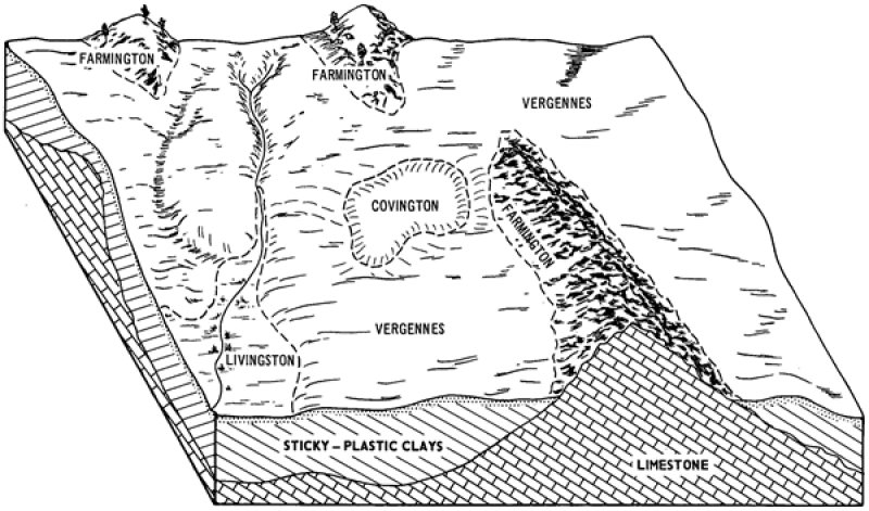
Figure 1. Block diagram of Clayplain ES (Vergennes soils) as represented in Chittenden County, Vermont.
Table 2. Representative physiographic features
| Geomorphic position, terraces |
(1) Tread |
|---|---|
| Hillslope profile |
(1) Toeslope (2) Footslope |
| Landforms |
(1)
Lake plain
> Flat
(2) Lake plain > Terrace (3) Lake plain > Hill (4) Hills > Ridge (5) Hills > Knoll |
| Runoff class | Low to medium |
| Flooding frequency | None |
| Ponding frequency | None |
| Elevation | 126 – 835 ft |
| Slope | 15% |
| Water table depth | 24 – 40 in |
| Aspect | Aspect is not a significant factor |
Table 3. Representative physiographic features (actual ranges)
| Runoff class | Low to very high |
|---|---|
| Flooding frequency | None |
| Ponding frequency | None |
| Elevation | 49 – 1,017 ft |
| Slope | 60% |
| Water table depth | 12 – 40 in |
Climatic features
The Koppen-Geiger climate classification of the area in which this MLRA occurs is Dfb, Warm-summer humid continental (Peel, Finlayson, and McMahon, 2007). The Lake Champlain Valley has a humid climate with cold winters and warm summers. Rainfall occurs as high-intensity, convective thunderstorms in the summer, and snowfall is heavy from late in autumn to early spring. The frost-free period in this area is longest in a narrow belt around Lake Champlain. The area falls within USDA Plant Hardiness zones 5a (and to a small extent, 5b). The lake influences the climate of the valley by moderating temperatures enough with offshore winds to delay the onset of fall, and similarly, to delay the advance of spring. Climate change scenarios for the Northeastern US predict an overall increase in temperature, particularly in the winter and predict a slight increase in annual precipitation.
Table 4. Representative climatic features
| Frost-free period (characteristic range) | 115-136 days |
|---|---|
| Freeze-free period (characteristic range) | 145-172 days |
| Precipitation total (characteristic range) | 36-41 in |
| Frost-free period (actual range) | 104-141 days |
| Freeze-free period (actual range) | 132-180 days |
| Precipitation total (actual range) | 34-42 in |
| Frost-free period (average) | 125 days |
| Freeze-free period (average) | 158 days |
| Precipitation total (average) | 38 in |
Figure 2. Monthly precipitation range
Figure 3. Monthly minimum temperature range
Figure 4. Monthly maximum temperature range
Figure 5. Monthly average minimum and maximum temperature
Figure 6. Annual precipitation pattern
Figure 7. Annual average temperature pattern
Climate stations used
-
(1) BURLINGTON INTL AP [USW00014742], South Burlington, VT
-
(2) SOUTH HERO [USC00437607], South Hero, VT
-
(3) WHITEHALL [USC00309389], Whitehall, NY
-
(4) SALISBURY 2 N [USC00437098], Salisbury, VT
Influencing water features
This ecological site is not influenced by wetland or riparian water features.
Due to the heavy clay nature of these soils, from late in fall to early in spring, water is often less than 2 feet below the soil surface. It recedes to a depth of 2 feet or more during drier periods. These areas may puddle if worked on when wet, creating micro-depressions in the landscape.
Soil features
The site consists of very deep, somewhat poorly- to moderately well-drained soils that are clayey throughout their profile. They formed in calcareous estuarine and glaciolacustrine clays. Representative soils include Glassaquic Hapludalfs (Vergennes, Hudson), Aquic Hapludalfs (Wilpoint), Aeric Endoaqualfs (Kingsbury, Chaumont, Churchville, Rhinebeck), and Oxyaquic Glossudalfs (Cayuga).
These soils have redox features throughout the subsoils, which often become more distinct as depth increases. These soils retain a high chroma and value in the upper part of the profile which indicates the upper subsoil is not frequently wet, but the lower part is saturated for significant periods. An argillic horizon, a subsurface layer with a higher clay content than the layers above it, indicating clay illuviation, will serve to perch water and result in a higher water-table. These are diagnostic horizons that will occur between 22 to 76 inches (56 to 183 centimeters) below the soil surface. These heavy clay soils have a moderate or high shrink-swell potential and will be reflected as cloddy structure with surface cracks when dry if unvegetated. This can lead to surface runoff and erosion issues.
***A NRCS Dynamics Soils Property (DSP) project (NASIS Project ID '2020-DSP-PAS-001) assessed the soil aggregate stability and nutrient loads present within three different land uses (forested areas, hayfields, and agricultural fields) along this soils catena. The three soil profile descriptions below show the drastic change different management strategies can have on soil health, structure, and composition. The results are below:
Bulk density (g cm-3) of three different land uses was collected by soil horizon and analyzed using a slab-wise aggregation at one centimeter intervals for surface and subsurface depths. The following results will reflect the 10th quartile (X10), the median (X50), and 90th quartile (X90), respectfully.
Forested (State 1 - Reference State / Minimally Managed)
Surface (0 to 10cm) : 0.68, 0.91, 1.22
Subsurface (11 to 50cm) : 1.12, 1.19, 1.31
Subsurface (51 to 100cm) : 1.13, 1.21, 1.32
Cropland (State 2 - Agricultural Row Crops)
Surface (0 to 10cm) : 1.07, 1.19, 1.21
Subsurface (11 to 50cm) : 1.18, 1.23, 1.26
Subsurface (51 to 100cm) : 1.18, 1.20, 1.26
Hayfield (State 3 - Managed Grassland)
Surface (0 to 10cm) : 0.86, 1.07, 1.24
Subsurface (11 to 50cm) : 1.13, 1.27, 1.41
Subsurface (51 to 100cm) : 1.23, 1.29, 1.36
Other laboratory analysis is currently being done by the Kellogg Soil Survey Laboratory and will be populated once available.

Figure 8. Soil profile of a Rhinebeck series (Aeric Endoaqualfs) in a minimally managed secondary forest.

Figure 9. Soil profile of a Rhinebeck series (Aeric Endoaqualfs) in a managed grassland (hay field).

Figure 10. Soil profile of a Kingsbury series (Typic Endoaqualfs) in an agriculture state (row crops).

Figure 11. Surface cracks and cloddy structure on the topsoil in a conventionally tilled agricultural state (row crops).
Table 5. Representative soil features
| Parent material |
(1)
Glaciolacustrine deposits
(2) Glaciomarine deposits (3) Sedimentary rock |
|---|---|
| Surface texture |
(1) Silty clay loam (2) Silty clay (3) Silt loam |
| Family particle size |
(1) Very-fine (2) Fine |
| Drainage class | Somewhat poorly drained to moderately well drained |
| Permeability class | Very slow |
| Depth to restrictive layer | Not specified |
| Soil depth | 80 in |
| Surface fragment cover <=3" | Not specified |
| Surface fragment cover >3" | Not specified |
| Available water capacity (0-40in) |
5 in |
| Calcium carbonate equivalent (0-40in) |
15% |
| Electrical conductivity (0-40in) |
Not specified |
| Sodium adsorption ratio (0-40in) |
Not specified |
| Soil reaction (1:1 water) (0-40in) |
6.6 – 8.2 |
| Subsurface fragment volume <=3" (0-40in) |
2% |
| Subsurface fragment volume >3" (0-40in) |
Not specified |
Table 6. Representative soil features (actual values)
| Drainage class | Somewhat poorly drained to moderately well drained |
|---|---|
| Permeability class | Very slow to moderately slow |
| Depth to restrictive layer | Not specified |
| Soil depth | 80 in |
| Surface fragment cover <=3" | 2% |
| Surface fragment cover >3" | Not specified |
| Available water capacity (0-40in) |
3 – 6 in |
| Calcium carbonate equivalent (0-40in) |
25% |
| Electrical conductivity (0-40in) |
Not specified |
| Sodium adsorption ratio (0-40in) |
Not specified |
| Soil reaction (1:1 water) (0-40in) |
4.5 – 9 |
| Subsurface fragment volume <=3" (0-40in) |
13% |
| Subsurface fragment volume >3" (0-40in) |
10% |
Ecological dynamics
The vegetation groupings described in this section are based on the terrestrial ecological system classification and vegetation associations developed by NatureServe (Comer et al., 2003) and localized associations provided by the Vermont Fish and Wildlife Department Natural Heritage Inventory (Thompson, Sorrenson, and Zaino, 2019).
The reference community of this site is equivalent to the NatureServe plant association CEGL006122 - "Quercus alba - Acer rubrum - Carya ovata / Viburnum acerifolium / Waldsteinia fragarioides Clayplain Forest" and the 'Wetland, Woodland, Wildland - A Guide to the Natural Communities of Vermont' (Thompson, Sorrenson, and Zaino, 2019) "Mesic Clayplain Forest" plant association.
This community is described as a mesic deciduous forest that occurs on the clay and silt soils of the Champlain Valley, dominant prior to European settlement. Under the reference condition, the site is characterized by mature trees, well-developed strata, and high species diversity. More research is needed to determine the extent in the nearby eastern Ontario Plain and adjacent Canada.
Small scale disturbances were the most common disturbances of these communities, often seen as individual tip ups from windstorm damage, mortality from ice shearing or snow loading, old age, or insect / disease. These disturbances would often create small changes in microtopography which would yield slight changes in species composition (Thompson and Sorrenson, 2010). Wetter areas, found within the matrix of this community, would often include more diverse species and a more well-defined shrub and herbaceous layer.
These clay soils are deep and fertile, resulting in long term conversion to agricultural fields. Today the reference condition is rare and critically imperiled (NatureServe, 2004). Complete removal of all native vegetation, mechanical disturbance to the soil (tilling, land leveling, etc.), and planting of desired grass /legume mixtures or crops converts the site for alternative land use, most of which today is pasture for dairy cows and corn fields. These cultural states can persist for long periods of time following proper management. When management of cropland or pastureland ceases, post-agricultural successional trends show the encroachment of undesirable non-native grasses, forbs, and scattered shrubs. Through proper management following short-term abandonment these fallow fields can transition back to fully operating pastures or cropland. If left unmanaged, early successional native and non-native trees and shrubs can become established, resulting in a patchy mosaic which may eventually revert to an early- to mid-successional forested state.
The most common post-agricultural succession community is often characterized as an open to closed white pine forest, with scattered early successional species such as green ash, quaking aspen, red maple, red cedar, and paper birch. Over time these hardwoods may form the dominant canopy under a relict canopy of white pine, slowly reverting to the reference condition where pine is not a dominant canopy species. Factors such as competition from invasive species, loss of viable seedbed, and loss of slight ground disturbances may result in diminished regeneration of oak seedlings that are characteristic of the pre-settlement reference condition (Murray and D’Amato, 2019). The remaining forested habitats are highly fragmented due to conversion to cultural states and often reflect large amounts of non-native and undesirable species. Only manual removal, monitoring of newly established invasive plants, and judicious planting of native trees and shrubs can convert these sites to a semblance of the reference state.
State and transition model
More interactive model formats are also available.
View Interactive Models
Click on state and transition labels to scroll to the respective text
Ecosystem states
| T1A | - | Natural Vegetation Clearing, Site Preparation, Planting of Crops |
|---|---|---|
| T1B | - | Natural Vegetation Clearing, Site Preparation, Introduction of Native and Non-Native Pasture Grasses and Legumes |
| R2A | - | Site Preparation, Reintroduce Tree Saplings and Native Species to Area |
| T3B | - | Long-term Post-Agricultural Succession |
| T3A | - | Removal of Grasses, Introduction of Crops |
| R3A | - | Site Preparation, Reintroduce Tree Saplings and Native Species to Area |
| T4A | - | Time, Natural Succession |
State 1 submodel, plant communities
| 1.1A | - | Large Scale Disturbances (Clearcutting, wind events, insect damage, snow/ice damage, etc.) |
|---|---|---|
| 1.1B | - | Small Scale Disturbances (single tree mortality) |
| 1.2A | - | Natural Succession over Time |
| 1.3A | - | Large Scale Disturbances (Clearcutting, wind events, insect damage, snow/ice damage, etc.) |
| 1.3B | - | Natural Succession over Time, Shade Tolerant Species Dominate |
| 1.4A | - | Oak Recruitment, Natural Succession over Time |
| 1.4B | - | Large Scale Disturbances (Clearcutting, wind events, insect damage, snow/ice damage, etc.) |
State 2 submodel, plant communities
| 2.1A | - | Reduced or Eliminated Tillage Operations, Crop Rotations Occur at Regular Intervals, Crop Residue and Amendments Remain on the Soil Surface, Planting of Cover Crops |
|---|---|---|
| 2.2A | - | Intensive Tillage Operations, Monoculture of Row Cropping Establishment |
State 3 submodel, plant communities
| 3.1A | - | Reduced or Eliminated Grassland Management Operations, Natural Succession to Predominantly Invasive and Incursive Shrubs |
|---|---|---|
| 3.2A | - | Removal of Undesirable Species via Management Practices (Brush, Chemical, etc.) |
State 4 submodel, plant communities
| 4.1A | - | Time, Maturation of Replanted Species |
|---|---|---|
| 4.1B | - | Individual Species Die Off, Replanting or Natural Reseeding Occurs |
| 4.2A | - | Individual Species Die Off, Replanting or Natural Reseeding Occurs |
State 1
Reference State / Minimally Managed

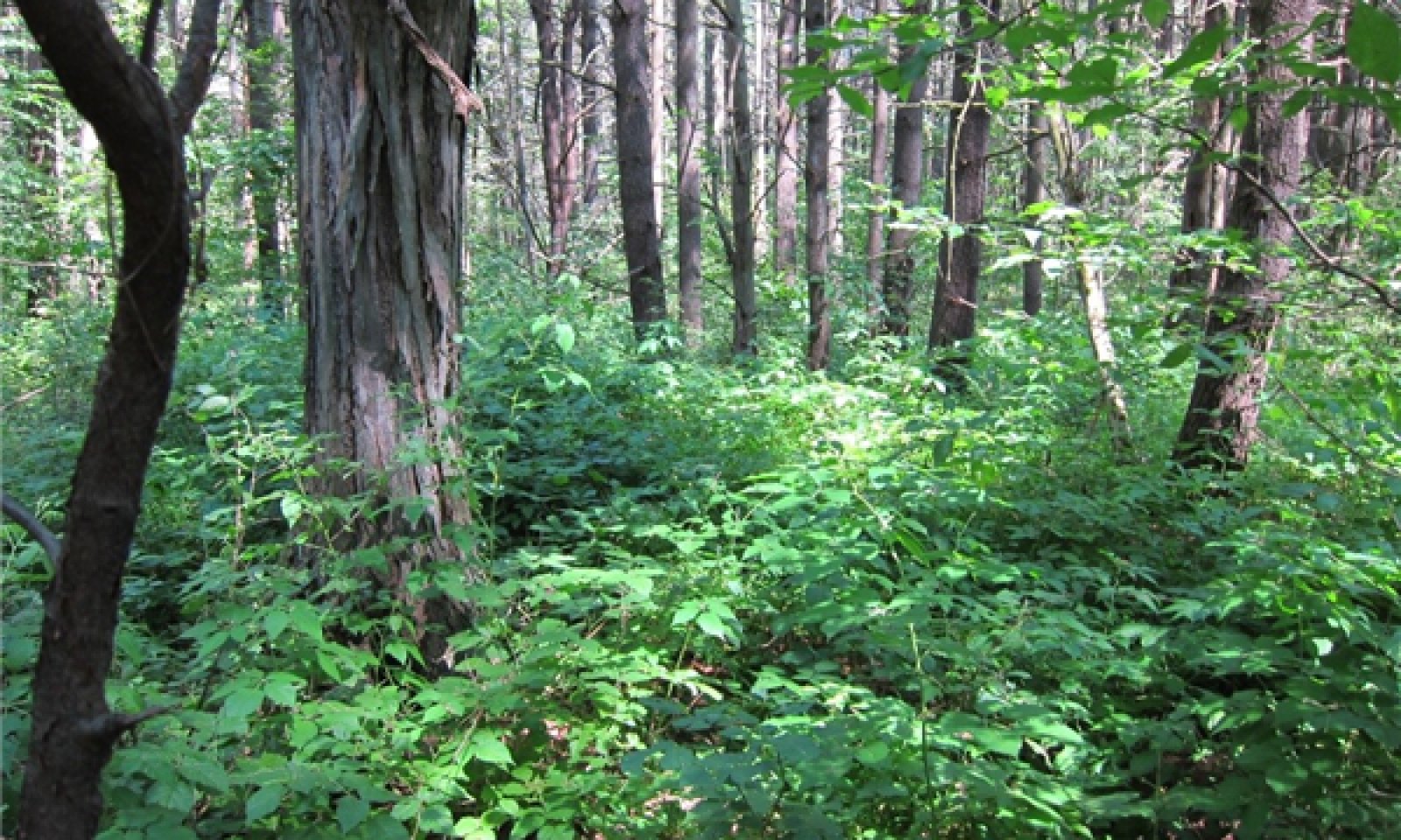
Figure 12. Mature mesic clayplain forest showcasing diverse species of overstory hardwoods and a diverse understory of forbs. This picture was part of the 2015 NatureServe Ecological Site Inventory project.
This state represents the reference mesic clayplain forest. The tree canopy is generally closed to partially open. Shrub and herb layers are of variable cover. These were once expansive forests within the Champlain Valley prior to European settlement and have since been subjected to intensive land use conversion and disturbances.
Dominant resource concerns
-
Plant productivity and health
-
Plant structure and composition
-
Plant pest pressure
-
Terrestrial habitat for wildlife and invertebrates
Community 1.1
Late Successional Mesic Clayplain Forest

Figure 13. Mature Mesic Clayplain Forest. Image taken during 2015 NatureServe agreement for Ecological Site Inventory of the Champlain Valley.
This condition represents the dominant historical condition of mesic clayplain forests. These are typically uneven age late successional forests (Thompson, Sorenson, and Zaino, 2019). Dominant drivers consist of localized disturbances from wind events and ice storms, creating tip ups that provide microhabitats for understory species and tree regeneration. Fire was thought to be the preeminent driver of oak regeneration (whether intentionally lit by local tribes or entering the community from pyrogenic uplands), preventing shade tolerant species from being dominant (Murray and D’Amato, 2019). Other limiting factors to oak regeneration are believed to be wind disturbances (not creating canopy gaps large enough for oak regeneration to successfully recruit into the overstory), deer browse, and past land use (fragmentation of habitat prevents seed dispersal, agricultural conversion, etc.). These will typically occur on more sloping land were clearing for past agriculture may not have occurred. This community correlates with NatureServes 'Quercus alba - Acer rubrum - Carya ovata / Viburnum acerifolium / Waldsteinia fragarioides Clayplain Forest' Association (CEGL006122).
Forest overstory. The closed canopy is Green ash, and Swamp wite oak admixed with slippery elm and red maple. Occasional trees include white pine and eastern hemlock. Northern white cedar is sometimes present.
Forest understory. The shrub layer is typically well developed consisting of Viburnum acerifolium (Maple-leaf viburnum), Rosa carolina (Carolina rose), Hamamelis virginiana (witch hazel), Rubus pubescens (dwarf raspberry), R. hispidus (swamp dewberry) and / or Vaccinium angustifolium (low sweet blueberry). The herb layer can be dense and very diverse, consisting of Waldsteinia fragariodes (barren strawberry), Moehringia lateriflora (grove sandwort), Impatiens capensis (jewelweed), Geranium maculatum (wild geranium), Uvularia sessilifolia (sessile-leaf bellwort), and Circaea lutetiana (large enchanter’s nightshade). Graminoids may be sparse to locally abundant, typically occurring in canopy openings where light hits the forest floor. These may include Carex gracillima (graceful sedge), C. laxiculmis (loose sedge), C. rosea (rosy sedge), and C. pensylvanica (woodland sedge).
Dominant plant species
-
northern red oak (Quercus rubra), tree
-
white oak (Quercus alba), tree
-
eastern white pine (Pinus strobus), tree
-
eastern hemlock (Tsuga canadensis), tree
-
red maple (Acer rubrum), tree
-
shagbark hickory (Carya ovata), tree
-
American beech (Fagus grandifolia), tree
-
white ash (Fraxinus americana), tree
-
sugar maple (Acer saccharum), tree
-
bur oak (Quercus macrocarpa), tree
-
hophornbeam (Ostrya virginiana), tree
-
American hornbeam (Carpinus caroliniana), tree
-
green ash (Fraxinus pennsylvanica), tree
-
swamp white oak (Quercus bicolor), tree
-
mapleleaf viburnum (Viburnum acerifolium), shrub
-
Carolina rose (Rosa carolina), shrub
-
American witchhazel (Hamamelis virginiana), shrub
-
dwarf red blackberry (Rubus pubescens), shrub
-
bristly dewberry (Rubus hispidus), shrub
-
lowbush blueberry (Vaccinium angustifolium), shrub
-
graceful sedge (Carex gracillima), grass
-
spreading sedge (Carex laxiculmis), grass
-
rosy sedge (Carex rosea), grass
-
Pennsylvania sedge (Carex pensylvanica), grass
-
inland sedge (Carex interior), grass
-
Appalachian barren strawberry (Waldsteinia fragarioides), other herbaceous
-
bluntleaf sandwort (Moehringia lateriflora), other herbaceous
-
jewelweed (Impatiens capensis), other herbaceous
-
spotted geranium (Geranium maculatum), other herbaceous
-
broadleaf enchanter's nightshade (Circaea lutetiana), other herbaceous
-
sessileleaf bellwort (Uvularia sessilifolia), other herbaceous
Dominant resource concerns
-
Plant productivity and health
-
Plant structure and composition
-
Plant pest pressure
-
Terrestrial habitat for wildlife and invertebrates
Table 7. Soil surface cover
| Tree basal cover | 2% |
|---|---|
| Shrub/vine/liana basal cover | 1% |
| Grass/grasslike basal cover | 0-1% |
| Forb basal cover | 1-3% |
| Non-vascular plants | 0-5% |
| Biological crusts | 0% |
| Litter | 87-96% |
| Surface fragments >0.25" and <=3" | 0% |
| Surface fragments >3" | 0% |
| Bedrock | 0% |
| Water | 0% |
| Bare ground | 0% |
Table 8. Woody ground cover
| Downed wood, fine-small (<0.40" diameter; 1-hour fuels) | 5-36% |
|---|---|
| Downed wood, fine-medium (0.40-0.99" diameter; 10-hour fuels) | 2-10% |
| Downed wood, fine-large (1.00-2.99" diameter; 100-hour fuels) | 2-5% |
| Downed wood, coarse-small (3.00-8.99" diameter; 1,000-hour fuels) | 1-3% |
| Downed wood, coarse-large (>9.00" diameter; 10,000-hour fuels) | 1-2% |
| Tree snags** (hard***) | – |
| Tree snags** (soft***) | – |
| Tree snag count** (hard***) | |
| Tree snag count** (hard***) |
* Decomposition Classes: N - no or little integration with the soil surface; I - partial to nearly full integration with the soil surface.
** >10.16cm diameter at 1.3716m above ground and >1.8288m height--if less diameter OR height use applicable down wood type; for pinyon and juniper, use 0.3048m above ground.
*** Hard - tree is dead with most or all of bark intact; Soft - most of bark has sloughed off.
Table 9. Canopy structure (% cover)
| Height Above Ground (ft) | Tree | Shrub/Vine | Grass/ Grasslike |
Forb |
|---|---|---|---|---|
| <0.5 | – | – | – | – |
| >0.5 <= 1 | – | – | – | – |
| >1 <= 2 | – | – | – | – |
| >2 <= 4.5 | – | – | 0-15% | 25-60% |
| >4.5 <= 13 | – | 15-15% | – | – |
| >13 <= 40 | 0-5% | – | – | – |
| >40 <= 80 | 60-80% | – | – | – |
| >80 <= 120 | – | – | – | – |
| >120 | – | – | – | – |
Community 1.2
Graminoid / Low Shrublands - Absent to Very Sparse Overstory - (Temporary Dominance)

Figure 14. Canopy gap opening representing a graminoid dominant phase consisting primarily of Carex and other forbs in lesser amounts. Vegetation subplot note within NASIS Veg Plot ID 2024VT007001.
This condition represents graminoid dominant and shrublands of temporary dominance following localized disturbances. This can be the result of large-scale disturbances such as clear cuts or naturalized mortality from wind events. Increased light availability allows for the dominance of shrubs and annual forbs while available tree saplings begin to grow into the overstory.
Forest overstory. The overstory will often be absent of live trees or very sparse, allowing for high amounts of light to reach the forest floor and the temporary dominance of understory species to flourish before saplings become dominant and grow greater than 15 feet in height.
Forest understory. These may consist of both native and introduced shrub species such as Vibrunum dentatum (southern arrowwood), Rubus pubescens (dwarf raspberry), R. hispidus (swamp dewberry), Rhamnus cathartica (common buckthorn), Fragaria virginiana (common strawberry), Lonicera morrowii (Morrow’s honeysuckle), Acer platanoides (Norway maple), and Rosa multiflora (multiflora rose).
Dominant plant species
-
eastern white pine (Pinus strobus), tree
-
viburnum (Viburnum), shrub
-
blackberry (Rubus), shrub
-
buckthorn (Rhamnus), shrub
-
honeysuckle (Lonicera), shrub
-
rose (Rosa), shrub
-
sedge (Carex), grass
-
Virginia strawberry (Fragaria virginiana), other herbaceous
-
sessileleaf bellwort (Uvularia sessilifolia), other herbaceous
-
spotted geranium (Geranium maculatum), other herbaceous
-
bedstraw (Galium), other herbaceous
Dominant resource concerns
-
Plant productivity and health
-
Plant structure and composition
Table 10. Canopy structure (% cover)
| Height Above Ground (ft) | Tree | Shrub/Vine | Grass/ Grasslike |
Forb |
|---|---|---|---|---|
| <0.5 | – | – | – | – |
| >0.5 <= 1 | – | – | – | – |
| >1 <= 2 | 0-25% | – | 10-25% | 25-80% |
| >2 <= 4.5 | – | 10-25% | – | – |
| >4.5 <= 13 | – | – | – | – |
| >13 <= 40 | – | – | – | – |
| >40 <= 80 | 0-25% | – | – | – |
| >80 <= 120 | – | – | – | – |
| >120 | – | – | – | – |
Community 1.3
Mixed Pine - Early Successional Mesic Clayplain Forest

Figure 15. White pine- early successional species dominant forest on gentle slopes. The understory consists of primarily herbaceous litter and sparse forbs. Mid-successional hardwood trees are beginning to emerge. NASIS Veg Plot ID 2024VT021002,

Figure 16. White pine (Pinus strobus) dominated forest on gentle slopes. These are often a result of post agriculture succession or past harvest. Other early successional species are beginning to emerge. NASIS Veg Plot ID 2024VT001002.

Figure 17. White oak (Quercus alba) seedling present in the understory among a high amounts of pine litter and other forbs. NASIS Veg Plot ID 2024VT001002.
This condition represents the successional condition of a post-harvested or long-term agricultural abandonment reverted to an even-aged early succession forest. In time, pine and other early successional species will begin to thin out and will become replaced with mid- to late-successional species like that of the reference community. Oak regeneration and saplings are often minimal without small scale disturbances.
Forest overstory. Pinus strobus (white pine) is a canopy dominant, often of a single age class, but mixed with various other early to mid-successional species. These may include species such as Fraxinus pennsylvanica (green ash), Populus tremuloides (quaking aspen), Juniperus virginiana (eastern red cedar), Acer rubrum (red maple), Betula papyrifera (paper birch), Quercus macrocarpa (bur oak), and Fraxinus americana (white ash) may become dominant for a period. Shade tolerant mid to late successional species such as Tusga canadensis (eastern hemlock) and Fagus grandifolia (American beech) may be present in some amount in the midstory and understory
Forest understory. The understory is highly variable, but will often consist of a high percentage of leaf litter, predominantly pine needles. Forbs and low shrubs will be present in small amounts and tree regeneration will occur as single scattered individuals.
Dominant plant species
-
eastern white pine (Pinus strobus), tree
-
quaking aspen (Populus tremuloides), tree
-
paper birch (Betula papyrifera), tree
-
eastern redcedar (Juniperus virginiana), tree
-
sugar maple (Acer saccharum), tree
-
hophornbeam (Ostrya virginiana), tree
-
American elm (Ulmus americana), tree
-
oak (Quercus), tree
-
common buckthorn (Rhamnus cathartica), shrub
-
chokecherry (Prunus virginiana), shrub
-
Virginia creeper (Parthenocissus quinquefolia), shrub
-
Morrow's honeysuckle (Lonicera morrowii), shrub
-
bedstraw (Galium), other herbaceous
-
Virginia strawberry (Fragaria virginiana), other herbaceous
-
feathery false lily of the valley (Maianthemum racemosum), other herbaceous
-
wreath goldenrod (Solidago caesia), other herbaceous
-
broadleaf enchanter's nightshade (Circaea lutetiana), other herbaceous
Dominant resource concerns
-
Plant productivity and health
-
Plant structure and composition
Table 11. Woody ground cover
| Downed wood, fine-small (<0.40" diameter; 1-hour fuels) | 10-40% |
|---|---|
| Downed wood, fine-medium (0.40-0.99" diameter; 10-hour fuels) | 10-30% |
| Downed wood, fine-large (1.00-2.99" diameter; 100-hour fuels) | 5-10% |
| Downed wood, coarse-small (3.00-8.99" diameter; 1,000-hour fuels) | 0-5% |
| Downed wood, coarse-large (>9.00" diameter; 10,000-hour fuels) | 0-2% |
| Tree snags** (hard***) | – |
| Tree snags** (soft***) | – |
| Tree snag count** (hard***) | 10-20 per acre |
| Tree snag count** (hard***) | 0-20 per acre |
* Decomposition Classes: N - no or little integration with the soil surface; I - partial to nearly full integration with the soil surface.
** >10.16cm diameter at 1.3716m above ground and >1.8288m height--if less diameter OR height use applicable down wood type; for pinyon and juniper, use 0.3048m above ground.
*** Hard - tree is dead with most or all of bark intact; Soft - most of bark has sloughed off.
Table 12. Canopy structure (% cover)
| Height Above Ground (ft) | Tree | Shrub/Vine | Grass/ Grasslike |
Forb |
|---|---|---|---|---|
| <0.5 | – | – | – | – |
| >0.5 <= 1 | – | – | – | – |
| >1 <= 2 | 0-5% | 0-5% | 0-2% | 10-25% |
| >2 <= 4.5 | – | – | – | – |
| >4.5 <= 13 | 0-10% | 0-5% | – | – |
| >13 <= 40 | 15-30% | – | – | – |
| >40 <= 80 | 30-75% | – | – | – |
| >80 <= 120 | – | – | – | – |
| >120 | – | – | – | – |
Community 1.4
Mid-Successional Mesic Clayplain Forest

Figure 18. Mid-successional clayplain forest with early to mid succession hardwood species dominant in the overstory and an understory of herbaceous litter, shrubs and forbs. NASIS Veg Plot ID 2024VT007001

Figure 19. Mid-successional forest with shagbark hickory, green ash, and maples present as moderate sized canopy trees with shrubs and forbs dominant in the understory. NASIS Veg Plot ID 2024VT007001.

Figure 20. Burr oak (Quercus macrocarpa) seedlings present in the understory of a mid-successional clayplain forest. NASIS Veg Plot ID 2024VT007001.
This condition represents a mid-successional mesic clayplain forest, distinguished by the lack of pine and oak dominance in the overstory and minimal oak recruitment in the understory as well as the dominance of aggressive non-native, invasive shrubs. These are often the result of secondary growth stands or stands that have been converted from agriculture. Early successional species have lost their dominance in the overstory and is replaced by a mixed hardwood stand of mid- to late-successional species. This will typically occur in lesser sloped areas that have been cleared in the past for agricultural uses and are currently secondary growth.
Forest overstory. Hardwoods such as Betula lenta (sweet birch), Acer rubrum (red maple), Cayra ovata (shagbark hickory), Ostrya virginiana (eastern hophornbeam), and Fraxinus americana (white ash) are often present in the overstory. Conifers may include Pinus strobus (white pine) and / or Tsuga canadensis (eastern hemlock) in variable amounts. Remnant pine will often be present as a relict emergent canopy but are losing dominance and following tip ups will allow for release of understory saplings. Invasive species such as Acer plantinoides (Norway maple) will often make up variable amounts in the overstory.
Forest understory. Diverse forbs and low shrubs will often be present in the understory. Oak regeneration and saplings are often minimal. Invasive understory shrubs are often present, and will include but are not limited to Lonicera morrowii (Morrow's honeysuckle), Lonicera tatarica (tatarian honeysuckle), Berberis thunbergii (Japanese barberry), Rhamnus cathartica (European buckthorn), and Frangula alnus (alder buckthorn) may be present in the understory.
Dominant plant species
-
eastern white pine (Pinus strobus), tree
-
red maple (Acer rubrum), tree
-
shagbark hickory (Carya ovata), tree
-
hophornbeam (Ostrya virginiana), tree
-
white ash (Fraxinus americana), tree
-
eastern hemlock (Tsuga canadensis), tree
-
Norway maple (Acer platanoides), tree
-
green ash (Fraxinus pennsylvanica), tree
-
quaking aspen (Populus tremuloides), tree
-
birch (Betula), tree
-
oak (Quercus), tree
-
blue cohosh (Caulophyllum thalictroides), shrub
-
wild sarsaparilla (Aralia nudicaulis), shrub
-
honeysuckle (Lonicera), shrub
-
red mulberry (Morus rubra), shrub
-
Virginia creeper (Parthenocissus quinquefolia), shrub
-
eastern poison ivy (Toxicodendron radicans), shrub
-
common buckthorn (Rhamnus cathartica), shrub
-
grape (Vitis), shrub
-
sedge (Carex), grass
-
Virginia strawberry (Fragaria virginiana), other herbaceous
-
common dandelion (Taraxacum officinale), other herbaceous
-
common gypsyweed (Veronica officinalis), other herbaceous
-
littleleaf buttercup (Ranunculus abortivus), other herbaceous
-
feathery false lily of the valley (Maianthemum racemosum), other herbaceous
-
Canada mayflower (Maianthemum canadense), other herbaceous
-
bedstraw (Galium), other herbaceous
-
dogtooth violet (Erythronium americanum), other herbaceous
Dominant resource concerns
-
Plant productivity and health
-
Plant structure and composition
-
Terrestrial habitat for wildlife and invertebrates
Table 13. Woody ground cover
| Downed wood, fine-small (<0.40" diameter; 1-hour fuels) | 0-10% |
|---|---|
| Downed wood, fine-medium (0.40-0.99" diameter; 10-hour fuels) | 0-5% |
| Downed wood, fine-large (1.00-2.99" diameter; 100-hour fuels) | 0-5% |
| Downed wood, coarse-small (3.00-8.99" diameter; 1,000-hour fuels) | 0-3% |
| Downed wood, coarse-large (>9.00" diameter; 10,000-hour fuels) | 0-2% |
| Tree snags** (hard***) | – |
| Tree snags** (soft***) | – |
| Tree snag count** (hard***) | 0-10 per acre |
| Tree snag count** (hard***) | 0-20 per acre |
* Decomposition Classes: N - no or little integration with the soil surface; I - partial to nearly full integration with the soil surface.
** >10.16cm diameter at 1.3716m above ground and >1.8288m height--if less diameter OR height use applicable down wood type; for pinyon and juniper, use 0.3048m above ground.
*** Hard - tree is dead with most or all of bark intact; Soft - most of bark has sloughed off.
Table 14. Canopy structure (% cover)
| Height Above Ground (ft) | Tree | Shrub/Vine | Grass/ Grasslike |
Forb |
|---|---|---|---|---|
| <0.5 | – | – | – | – |
| >0.5 <= 1 | – | – | – | – |
| >1 <= 2 | 0-5% | 0-5% | 0-5% | 10-30% |
| >2 <= 4.5 | – | 5-10% | – | – |
| >4.5 <= 13 | – | 0-15% | – | – |
| >13 <= 40 | 5-15% | – | – | – |
| >40 <= 80 | 50-80% | – | – | – |
| >80 <= 120 | 0-10% | – | – | – |
| >120 | – | – | – | – |
Pathway 1.1A
Community 1.1 to 1.2
This transition may occur through large-scale disturbances including but not limited to clearcutting, large-scale wild events (hurricanes, nor'easters, etc.), pest insect outbreaks (emerald ash borer, etc.) or mortality from extreme snow / ice events. Fire in these systems may have been historically utilized by Native Americans. No recent reports of fire in these habitats has been issued.
Conservation practices
| Forest Land Management | |
|---|---|
| Prescribed Forestry | |
| Forest Management Plan - Written | |
| Forest Management Plan - Applied | |
| Creating forest openings to improve hardwood stands |
Pathway 1.1B
Community 1.1 to 1.3
This transition may occur through small scale disturbances, often seen but not limited to single tree tip ups and mortality, or selective harvesting.
Conservation practices
| Brush Management | |
|---|---|
| Upland Wildlife Habitat Management | |
| Prescribed Forestry | |
| Forest stand improvement for habitat and soil quality |
Pathway 1.2A
Community 1.2 to 1.3
This transition may occur as natural succession over time. As canopy gaps create areas of temporary importance dominated by shrubs and graminoids, assuming a seed source is available, seedlings and sapling will begin to grow. Fast growing shade intolerant species such as white pine are often dominant in the regrowth process.
Pathway 1.3A
Community 1.3 to 1.2
This transition may occur through large- or small-scale disturbances including but not limited to clearcutting, large-scale wild events (hurricanes, nor'easters, etc.), pest insect outbreaks (emerald ash borer, etc.) or mortality from extreme snow / ice events. Fire in these systems may have been historically utilized by Native Americans. No recent reports of fire in these habitats has been issued.
Conservation practices
| Forest Land Management | |
|---|---|
| Prescribed Forestry | |
| Forest Management Plan - Written | |
| Forest Management Plan - Applied | |
| Creating forest openings to improve hardwood stands |
Pathway 1.3B
Community 1.3 to 1.4
This transition may occur as natural succession over time. White pine and other early successional species will either self-thin or can be thinned manually as time passes, opening the canopy for mid-successional hardwood species to begin to grow.
Conservation practices
| Forest Stand Improvement | |
|---|---|
| Forest stand improvement for habitat and soil quality | |
| Creating forest openings to improve hardwood stands |
Pathway 1.4A
Community 1.4 to 1.1
This transition may occur as natural succession and oak recruitment in the understory create a forest resembling the reference condition of a late succession mesic clayplain forest. Pine will have lost its dominance in the canopy and be replaced by oak and other mixed hardwood dominance. Many of these forests will require some sort of management to address invasive or non-native plant species and can be removed via chemical, biological, or mechanical means.
Conservation practices
| Forest Stand Improvement | |
|---|---|
| Forest Land Management | |
| Invasive Plant Species Control |
Pathway 1.4B
Community 1.4 to 1.2
This transition may occur through large- or small-scale disturbances including but not limited to clearcutting, large-scale wild events (hurricanes, nor'easters, etc.), pest insect outbreaks (emerald ash borer, etc.) or mortality from extreme snow / ice events. Fire in these systems may have been historically utilized by Native Americans. No recent reports of fire in these habitats has been issued.
Conservation practices
| Forest Stand Improvement | |
|---|---|
| Prescribed Forestry | |
| Forest Management Plan - Written | |
| Forest Management Plan - Applied | |
| Creating forest openings to improve hardwood stands |
State 2
Agricultural Row Crops

Figure 21. Corn field in the early growing season (May) 2024 on a conservationally tilled site. NASIS Veg Plot ID 2024VT001001.
This state represents a once forested area now cleared for cropland. This will typically only occur on gentler slopes (less than15 percent) due to potential for water erosion. Corn is the dominant agricultural row crop on this site.
Dominant resource concerns
-
Sheet and rill erosion
-
Ephemeral gully erosion
-
Compaction
-
Organic matter depletion
-
Aggregate instability
-
Inefficient irrigation water use
-
Nutrients transported to surface water
-
Nutrients transported to ground water
-
Plant productivity and health
-
Feed and forage imbalance
Community 2.1
Conventional Tilled Row Crops
This phase consists of cleared and cultivated fields for annual or perennial crops that are heavily managed with regular soil disturbances.
Dominant resource concerns
-
Sheet and rill erosion
-
Ephemeral gully erosion
-
Compaction
-
Organic matter depletion
-
Aggregate instability
-
Nutrients transported to surface water
-
Pesticides transported to surface water
-
Plant productivity and health
-
Plant structure and composition
Community 2.2
Conservation Till Row and Cover Crops
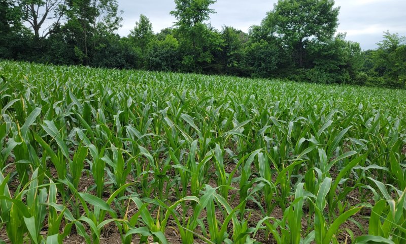
Figure 22. Conservation till practiced corn crop. NASIS Vegetation Plot ID 2024VT001001.
This phase consists of cleared and cultivated fields for annual or perennial crops that are managed with a conservation focus on tilling practices. These methods include strip till, vertical till, or no till systems. These methods may improve soil ecosystem function over time.
Dominant resource concerns
-
Plant productivity and health
-
Plant structure and composition
Pathway 2.1A
Community 2.1 to 2.2
This transition can occur through the reduction or elimination of conventional tillage practices and the implementation of conservation practices. Conservation strategies may vary depending on local site conditions and should be addressed with management planners. Through the long term conservation practices, soil physical and chemical properties should improve and pose less of a risk with land management issues.
Conservation practices
| Conservation Cover | |
|---|---|
| Conservation Crop Rotation | |
| Cover Crop | |
| Long Term No. Till | |
| Residue and Tillage Management, No-Till/Strip Till/Direct Seed |
Pathway 2.2A
Community 2.2 to 2.1
This transition can occur through the use of intensive, regular mechanical soil disturbances.
Conservation practices
| Deep Tillage |
|---|
State 3
Managed Grassland

Figure 23. First cut hay field in May of 2024 found on a Madalin taxadjunct series in Shelburne, Vermont. NASIS Veg Plot ID 2024VT007002.
This state represents a once forested area now cleared and managed as pasture or hay fields. This will typically only occur on gentler slopes (less than15 percent) due to potential for water erosion. Pasture vegetation can consist of grasses, legumes, other forbs, shrubs or a mixture. Many of these forages are introduced, having originally come from areas in other states or continents. Overgrazed pastures can lead to soil compaction and numerous bare spots, which may then become focal points of accelerated erosion and colonization sites of undesirable plants or weeds.
Dominant resource concerns
-
Sheet and rill erosion
-
Ephemeral gully erosion
-
Compaction
-
Organic matter depletion
-
Aggregate instability
-
Inefficient irrigation water use
-
Nutrients transported to surface water
-
Nutrients transported to ground water
-
Plant productivity and health
-
Terrestrial habitat for wildlife and invertebrates
-
Feed and forage imbalance
Community 3.1
Orchardgrass - Smooth Brome - Common Milkweed Early Successional Meadow

Figure 24. Third cut hay field late in the growing season (August) of 2024. NASIS Veg Plot ID 2024VT021001.
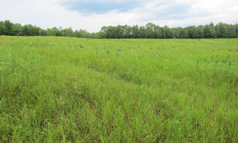
Figure 25. Uncut grassland field dominated by tall orchardgrass and other scattered forbs. This picture was part of the 2015 NatureServe Ecological Site Inventory project as a field reconnaissance point.

Figure 26. Hay field cut exclusion for wildlife habitat showing species seeding and what prior to haying would look like. Included as a site note adjacent to NASIS Veg Plot ID 2024VT021001.
This community phase represents commonly planted forage species on pastureland and hay land. The suite of plants established on any given site may vary considerably depending upon purpose, management goals, and usage (e.g., horse vs. cattle). Most systems include a mixture of non-native cool-season grasses and legumes that provide forage throughout the growing season. Several additional plants and/or species combinations maybe present depending on the objectives and management approaches of the land manager/owner. This may also be the result of bare soil after cessation of agriculture, and will be short-lived without annual mowing, but can persist indefinitely when actively managed.
Resilience management. Mechanical mowing, at least annually but ranging up to four times during the growing season, helps maintain these areas as dominant grasslands.
Forest overstory. Trees and shrubs are generally absent from these communities but may occur as scattered mature individuals as shade structures for grazing animals.
Forest understory. Common species may include cool season grasses such as Dactylis glomerata (orchardgrass), Bromus inermis (smooth brome), Phleum pratense (timothy), Anthoxanthum odoratum (sweet vernal grass), Poa pratensis (Kentucky bluegrass), Agrostis spp. (bentgrass), Festuca rubra / ovina (red / hard fescue), Lolium perenne (perennial rye), and x Festulolium. Legumes may include Medicago sativa (alfalfa), Trifolium pratense (red clover), and Astragalus spp. (milkvetch). Forbs may be less abundant and can include Galium spp. (bedstraw), Fragaria virginiana (Virginia strawberry), Heracleum spp. (cowparsnip), Rhinanthus spp. (yellow rattle), Solidago spp. (goldenrods), Ranunculus spp. (buttercups), & Hieracium spp. (hawkweed).
Dominant plant species
-
orchardgrass (Dactylis glomerata), grass
-
smooth brome (Bromus inermis), grass
-
timothy (Phleum pratense), grass
-
sweet vernalgrass (Anthoxanthum odoratum), grass
-
Kentucky bluegrass (Poa pratensis), grass
-
bentgrass (Agrostis), grass
-
red fescue (Festuca rubra), grass
-
sheep fescue (Festuca ovina), grass
-
perennial ryegrass (Lolium perenne), grass
-
festulolium (×Festulolium), grass
-
alfalfa (Medicago sativa), other herbaceous
-
red clover (Trifolium pratense), other herbaceous
-
common milkweed (Asclepias syriaca), other herbaceous
-
milkvetch (Astragalus), other herbaceous
-
bedstraw (Galium), other herbaceous
-
Virginia strawberry (Fragaria virginiana), other herbaceous
-
cowparsnip (Heracleum), other herbaceous
-
plantain (Plantago), other herbaceous
-
goldenrod (Solidago), other herbaceous
-
buttercup (Ranunculus), other herbaceous
Dominant resource concerns
-
Plant productivity and health
-
Plant structure and composition
-
Terrestrial habitat for wildlife and invertebrates
-
Feed and forage imbalance
Figure 27. Annual production by plant type (representative values) or group (midpoint values)
Table 15. Annual production by plant type
| Plant type | Low (lb/acre) |
Representative value (lb/acre) |
High (lb/acre) |
|---|---|---|---|
| Grass/Grasslike | 100 | 1563 | 3601 |
| Total | 100 | 1563 | 3601 |
Table 16. Ground cover
| Tree foliar cover | 0% |
|---|---|
| Shrub/vine/liana foliar cover | 0-10% |
| Grass/grasslike foliar cover | 30-95% |
| Forb foliar cover | 5-80% |
| Non-vascular plants | 0% |
| Biological crusts | 0% |
| Litter | 20-80% |
| Surface fragments >0.25" and <=3" | 0-2% |
| Surface fragments >3" | 0% |
| Bedrock | 0% |
| Water | 0% |
| Bare ground | 2-5% |
Table 17. Soil surface cover
| Tree basal cover | 0% |
|---|---|
| Shrub/vine/liana basal cover | 0-5% |
| Grass/grasslike basal cover | 30-75% |
| Forb basal cover | 0-6% |
| Non-vascular plants | 0% |
| Biological crusts | 0% |
| Litter | 40-98% |
| Surface fragments >0.25" and <=3" | 0-30% |
| Surface fragments >3" | 0% |
| Bedrock | 0% |
| Water | 0% |
| Bare ground | 0-2% |
Table 18. Canopy structure (% cover)
| Height Above Ground (ft) | Tree | Shrub/Vine | Grass/ Grasslike |
Forb |
|---|---|---|---|---|
| <0.5 | – | – | – | – |
| >0.5 <= 1 | – | – | – | – |
| >1 <= 2 | – | 0-5% | 0-100% | 0-50% |
| >2 <= 4.5 | – | – | – | – |
| >4.5 <= 13 | – | – | – | – |
| >13 <= 40 | 0-5% | – | – | – |
| >40 <= 80 | – | – | – | – |
| >80 <= 120 | – | – | – | – |
| >120 | – | – | – | – |
Community 3.2
Meadow Abandonment - Ruderal Grassland / Shrubland
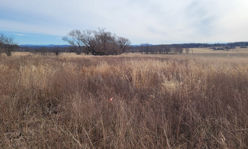
Figure 28. Abandoned pasture on NRCS easement in Bridport, VT. Undesirable forbs and invasive grasses present in high abundance. Last hayed was approximately 2008, photo taken 2025. NASIS Veg Plot ID 2025VT001002.
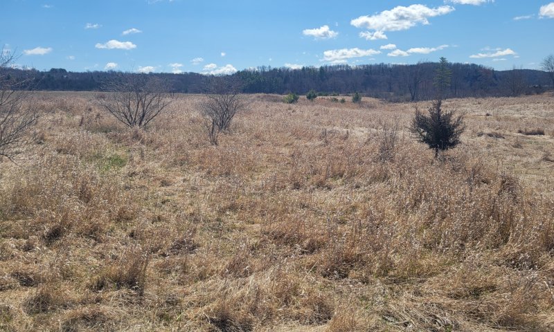
Figure 29. Abandoned pasture on NRCS easement in Bridport, VT. Undesirable forbs and grasses present in high abundance. Small trees are becoming established. Last hayed was approximately 2011, photo taken 2025. NASIS Veg Plot ID 2025VT001004.
This vegetation is comprised old fields dominated by shrubby thickets and / or tall undesirable forbs and grasses. Variable amounts of invasive plants are present. Small trees are often present but often form less than 25% cover and consist of early successional species. The herbaceous layer is variable depending on the density of shrub cover. Typical species are those associated with old fields, grasslands, and agricultural sites. Vines can be absent or dominant, sometimes covering the tall and short shrubs. This phase is characterized by an abundance of fleshy fruited shrubs, both native and non-native, that become established by bird and small mammal dispersal. Many of the successional meadow species remain in openings, usually forming a patchy mosaic (NatureServe 2015). This correlates with NatureServes 'Elaeagnus umbellata - Cornus racemosa - Rosa multiflora - Juniperus virginiana Ruderal Shrubland' Association (CEGL006451).
Dominant plant species
-
eastern redcedar (Juniperus virginiana), tree
-
paper birch (Betula papyrifera), tree
-
chokecherry (Prunus virginiana), tree
-
eastern white pine (Pinus strobus), tree
-
red maple (Acer rubrum), tree
-
Russian olive (Elaeagnus angustifolia), shrub
-
gray dogwood (Cornus racemosa), shrub
-
blackhaw (Viburnum prunifolium), shrub
-
Japanese honeysuckle (Lonicera japonica), shrub
-
Morrow's honeysuckle (Lonicera morrowii), shrub
-
European privet (Ligustrum vulgare), shrub
-
multiflora rose (Rosa multiflora), shrub
-
smooth sumac (Rhus glabra), shrub
-
staghorn sumac (Rhus typhina), shrub
-
Japanese barberry (Berberis thunbergii), shrub
-
blackberry (Rubus), shrub
-
sweet vernalgrass (Anthoxanthum odoratum), grass
-
Kentucky bluegrass (Poa pratensis), grass
-
red fescue (Festuca rubra), grass
-
little bluestem (Schizachyrium scoparium), grass
-
smooth brome (Bromus inermis), grass
-
redtop (Agrostis gigantea), grass
-
quackgrass (Elymus repens), grass
-
wrinkleleaf goldenrod (Solidago rugosa), other herbaceous
-
giant goldenrod (Solidago gigantea), other herbaceous
-
gray goldenrod (Solidago nemoralis), other herbaceous
-
common yellow oxalis (Oxalis stricta), other herbaceous
-
common blue violet (Viola sororia), other herbaceous
-
common milkweed (Asclepias syriaca), other herbaceous
-
garlic mustard (Alliaria petiolata), other herbaceous
-
false baby's breath (Galium mollugo), other herbaceous
-
common yarrow (Achillea millefolium), other herbaceous
-
Queen Anne's lace (Daucus carota), other herbaceous
-
clover (Trifolium), other herbaceous
Dominant resource concerns
-
Plant productivity and health
-
Plant structure and composition
-
Terrestrial habitat for wildlife and invertebrates
-
Feed and forage imbalance
Table 19. Canopy structure (% cover)
| Height Above Ground (ft) | Tree | Shrub/Vine | Grass/ Grasslike |
Forb |
|---|---|---|---|---|
| <0.5 | – | – | – | – |
| >0.5 <= 1 | – | – | – | – |
| >1 <= 2 | – | – | – | – |
| >2 <= 4.5 | – | 50-75% | 0-25% | 0-50% |
| >4.5 <= 13 | – | – | – | – |
| >13 <= 40 | 0-25% | – | – | – |
| >40 <= 80 | – | – | – | – |
| >80 <= 120 | – | – | – | – |
| >120 | – | – | – | – |
Pathway 3.1A
Community 3.1 to 3.2
This may occur when grassland management operations are reduced or eliminated, allowing for succession to predominately invasive and incursive shrubs.
Pathway 3.2A
Community 3.2 to 3.1
This may occur through the removal of undesirable species in a managed grassland and return to specific management practices for pasture or hay production.
Conservation practices
| Brush Management | |
|---|---|
| Prescribed Grazing | |
| Invasive Plant Species Control | |
| Grazing Management Plan | |
| Managed Haying/Grazing | |
| Biological suppression and other non-chemical techniques to manage brush, weeds and invasive species |
State 4
Potential Restoration State
This state represents an altered state that is undergoing restoration to reflect the mesic clayplain forest in composition and structure but also reflects the past land use. This may include a variety of phases that may or may not be successful.
Dominant resource concerns
-
Plant productivity and health
-
Plant structure and composition
-
Plant pest pressure
-
Terrestrial habitat for wildlife and invertebrates
Community 4.1
Even-Age Planted Saplings
This phase represents the beginning of restoration, in which saplings of the appropriate species are planted at the desired density. These may need to be protected from the browse of animals. The ground cover may be bare ground or undesirable pasture grasses and forbs.
Community 4.2
Even-Age Sapling Forest / Shrubland
This phase represents the even aged stand of saplings that have become established and begin growth at the desired density. The groundcover may be a mix of native and non-native species as well as variable amounts of bare ground.
Community 4.3
Uneven-Aged Sapling Forest / Shrubland
This phase represents a restoration attempt in which the trees may become different age classes, whether intentionally or not. Some saplings will become established and begin growth at undesired density, until natural seeding or replanting occurs. The groundcover may be a mix of native and non-native species as well as variable amounts of bare ground.
Pathway 4.1A
Community 4.1 to 4.2
This may occur when planted species become established at a restoration site and begin to grow under passive and active management.
Pathway 4.1B
Community 4.1 to 4.3
This may occur through single or group species die off and replanted or regrowth of species occurs. Species die off may occur through many reasons, including but not limited to herbivory, fungal disease, insect outbreaks, lack of nutrients, unsuited planting, etc.
Pathway 4.2A
Community 4.2 to 4.3
This may occur through single or group species die off and replanted or regrowth of species occurs. Species die off may occur through many reasons, including but not limited to herbivory, fungal disease, insect outbreaks, lack of nutrients, unsuited planting, etc.
Transition T1A
State 1 to 2
Converted forested communities have often undergone the clearing of native vegetation and site preparation before conversion to agricultural fields is complete. Due to the complex microtopography of the native site, land smoothing and / or leveling may be required, as well as undergoing practices such as tilling for the field to be ready to plant. Planting of desired crops can be done by hand or machine at desired spacing and intervals.
Transition T1B
State 1 to 3
Converted forested communities have often undergone the clearing of native vegetation and site preparation before conversion to a managed grassland state is complete. Due to the complex microtopography of the native site, land smoothing and / or leveling may be required. Planting of desired mixtures of grasses and / or legumes can be done by hand or machine at desired densities.
Transition T2A
State 2 to 3
Cropland can be converted to managed grasslands following the removal of the crop and the planting of desired mixtures of grasses and / or legumes at the desired density. Short term abandonment of crop fields may also give rise to ruderal shrublands and undesirable grasses and forbs that, if managed correctly, can be converted into a persistently managed grassland.
Restoration pathway R2A
State 2 to 4
Conversion from an agricultural state to a restored function state may require the removal of the crop and the reintroduction of tree saplings and other native species to the area. Measures may need to be taken to prevent excessive soil erosion and failure of establishment due to browse.
Conservation practices
| Tree/Shrub Site Preparation | |
|---|---|
| Tree/Shrub Establishment |
Transition T3B
State 3 to 1
Long-term abandonment of converted land may result in fallow fields that will allow for the growth and establishment of native and non-native species that over time can reflect an early- to mid-successional forest of the reference state. The presence of non-native species will often diminish the ecological value of the restored forest, but through proper management and care may reflect the reference condition over time.
Conservation practices
| Tree/Shrub Establishment | |
|---|---|
| Upland Wildlife Habitat Management | |
| Native Plant Community Restoration and Management | |
| Herbaceous Weed Control |
Transition T3A
State 3 to 2
Managed grassland can be converted to agricultural fields following the removal of the grasses / legumes (typically achieved by tilling) and planting the desired crop at the desired spacing and intervals.
Restoration pathway R3A
State 3 to 4
Conversion from a managed grassland state to a restored function state may require the cessation of management and the reintroduction of tree saplings and other native species to the area. Measures may need to be taken to prevent excessive soil erosion and failure of establishment due to browse. Passive restoration management may result in a condition similar to an old-field white pine forest, whereas active restoration management may result in more diverse species composition.
Conservation practices
| Tree/Shrub Site Preparation | |
|---|---|
| Tree/Shrub Establishment |
Transition T4A
State 4 to 1
Following the success of tree sapling establishment in restoration areas, natural seeding can occur and result in regrowth of forest species to the proper age and site classes.
Additional community tables
Table 20. Community 1.1 forest overstory composition
| Common name | Symbol | Scientific name | Nativity | Height (ft) | Canopy cover (%) | Diameter (in) | Basal area (square ft/acre) |
|---|---|---|---|---|---|---|---|
|
Tree
|
|||||||
| eastern white pine | PIST | Pinus strobus | Native | 33–66 | 10–25 | – | – |
| eastern hemlock | TSCA | Tsuga canadensis | Native | 33–66 | 10–25 | – | – |
| white ash | FRAM2 | Fraxinus americana | Native | 33–66 | 5–10 | – | – |
| northern red oak | QURU | Quercus rubra | Native | 33–66 | 5–10 | – | – |
| bigtooth aspen | POGR4 | Populus grandidentata | Native | 33–66 | 5–10 | – | – |
| white oak | QUAL | Quercus alba | Native | 33–66 | 2–5 | – | – |
| hophornbeam | OSVI | Ostrya virginiana | Native | – | – | – | – |
| shagbark hickory | CAOV2 | Carya ovata | Native | – | – | – | – |
| red maple | ACRU | Acer rubrum | Native | – | – | – | – |
| bitternut hickory | CACO15 | Carya cordiformis | Native | – | – | – | – |
| American beech | FAGR | Fagus grandifolia | Native | – | – | – | – |
| American basswood | TIAM | Tilia americana | Native | – | – | – | – |
| quaking aspen | POTR5 | Populus tremuloides | Native | – | – | – | – |
| shagbark hickory | CAOV2 | Carya ovata | – | – | – | – | – |
Table 21. Community 1.1 forest understory composition
| Common name | Symbol | Scientific name | Nativity | Height (ft) | Canopy cover (%) | |
|---|---|---|---|---|---|---|
|
Grass/grass-like (Graminoids)
|
||||||
| longstalk sedge | CAPE4 | Carex pedunculata | Native | 0.3–1.6 | 0.5–1 | |
| handsome sedge | CAFO4 | Carex formosa | Native | – | – | |
| plantainleaf sedge | CAPL4 | Carex plantaginea | Native | – | – | |
| rosy sedge | CARO22 | Carex rosea | Native | – | – | |
| whitegrass | LEVI2 | Leersia virginica | Native | – | – | |
| Pennsylvania sedge | CAPE6 | Carex pensylvanica | Native | – | – | |
|
Forb/Herb
|
||||||
| wild sarsaparilla | ARNU2 | Aralia nudicaulis | Native | 0.3–1.6 | 0.5–1 | |
| Appalachian barren strawberry | WAFR | Waldsteinia fragarioides | Native | 0.3–1.6 | 0.5–1 | |
| pointedleaf ticktrefoil | DEGL5 | Desmodium glutinosum | Native | 0.3–1.6 | 0.5–1 | |
| broadleaf helleborine | EPHE | Epipactis helleborine | Introduced | 0.3–1.6 | 0.5–1 | |
| longstyle sweetroot | OSLO | Osmorhiza longistylis | Native | 0.3–1.6 | 0.5–1 | |
| broadleaf enchanter's nightshade | CILUC | Circaea lutetiana ssp. canadensis | Native | – | – | |
| spotted geranium | GEMA | Geranium maculatum | Native | – | – | |
| white snakeroot | AGAL5 | Ageratina altissima | Native | – | – | |
| American hogpeanut | AMBR2 | Amphicarpaea bracteata | Native | – | – | |
| Canadian woodnettle | LACA3 | Laportea canadensis | Native | – | – | |
| woodland sunflower | HEDI2 | Helianthus divaricatus | Native | – | – | |
| gaywings | POPA5 | Polygala paucifolia | Native | – | – | |
| white baneberry | ACPA | Actaea pachypoda | Native | – | – | |
| largefruit blacksnakeroot | SATR4 | Sanicula trifoliata | Native | – | – | |
| wreath goldenrod | SOCA4 | Solidago caesia | Native | – | – | |
|
Fern/fern ally
|
||||||
| intermediate woodfern | DRIN5 | Dryopteris intermedia | Native | 0.3–1.6 | 0.5–1 | |
| Christmas fern | POAC4 | Polystichum acrostichoides | Native | 0.3–1.6 | 0.5–1 | |
| northern maidenhair | ADPE | Adiantum pedatum | Native | – | – | |
|
Shrub/Subshrub
|
||||||
| American witchhazel | HAVI4 | Hamamelis virginiana | Native | 7–16 | 5–10 | |
| American hornbeam | CACA18 | Carpinus caroliniana | Native | 3–16 | 2–5 | |
| mapleleaf viburnum | VIAC | Viburnum acerifolium | Native | – | – | |
| eastern leatherwood | DIPA9 | Dirca palustris | Native | – | – | |
| alternateleaf dogwood | COAL2 | Cornus alternifolia | Native | – | – | |
| American witchhazel | HAVI4 | Hamamelis virginiana | Native | – | – | |
|
Tree
|
||||||
| striped maple | ACPE | Acer pensylvanicum | Native | 7–16 | 5–10 | |
| American beech | FAGR | Fagus grandifolia | Native | 7–16 | 1–2 | |
| white ash | FRAM2 | Fraxinus americana | Native | 3–16 | 1–2 | |
| quaking aspen | POTR5 | Populus tremuloides | Native | – | – | |
| sweet birch | BELE | Betula lenta | Native | – | – | |
|
Vine/Liana
|
||||||
| eastern poison ivy | TORA2 | Toxicodendron radicans | Native | 0.3–1.6 | 0.5–1 | |
| Virginia creeper | PAQU2 | Parthenocissus quinquefolia | Native | 0.3–1.6 | 0.5–1 | |
Table 22. Community 1.4 forest overstory composition
| Common name | Symbol | Scientific name | Nativity | Height (ft) | Canopy cover (%) | Diameter (in) | Basal area (square ft/acre) |
|---|---|---|---|---|---|---|---|
|
Tree
|
|||||||
| red maple | ACRU | Acer rubrum | Native | 15–80 | 5–25 | – | – |
| Norway maple | ACPL | Acer platanoides | Introduced | 50–80 | 10–20 | 10–14 | – |
| shagbark hickory | CAOV2 | Carya ovata | Native | 15–40 | 10–20 | – | – |
| green ash | FRPE | Fraxinus pennsylvanica | Native | 15–80 | 5–15 | – | – |
| eastern white pine | PIST | Pinus strobus | Native | 80–110 | 5–15 | 16–25 | – |
| quaking aspen | POTR5 | Populus tremuloides | Native | 40–80 | 5–10 | – | – |
Table 23. Community 3.1 forest understory composition
| Common name | Symbol | Scientific name | Nativity | Height (ft) | Canopy cover (%) | |
|---|---|---|---|---|---|---|
|
Grass/grass-like (Graminoids)
|
||||||
| sweet vernalgrass | ANOD | Anthoxanthum odoratum | Introduced | 0–3 | 50–75 | |
| orchardgrass | DAGL | Dactylis glomerata | Introduced | 0–3 | 50–75 | |
| smooth brome | BRIN2 | Bromus inermis | Introduced | 0–3 | 25–50 | |
| timothy | PHPR3 | Phleum pratense | Introduced | 0–3 | 10–25 | |
| erect brome | BRER3 | Bromus erectus | Introduced | 0–3 | 2–5 | |
| plantainleaf sedge | CAPL4 | Carex plantaginea | Introduced | 0–3 | 0–2 | |
|
Forb/Herb
|
||||||
| common milkweed | ASSY | Asclepias syriaca | Native | 0–3 | 0–10 | |
| oxeye daisy | LEVU | Leucanthemum vulgare | Introduced | 0–3 | 0–10 | |
| Canada goldenrod | SOAL6 | Solidago altissima | Native | 0–3 | 0–10 | |
| goldenrod | SOLID | Solidago | Native | 0–6 | 0–10 | |
|
Shrub/Subshrub
|
||||||
| Morrow's honeysuckle | LOMO2 | Lonicera morrowii | Introduced | 0–3 | 0–1 | |
| silky dogwood | COAM2 | Cornus amomum | Native | 0–3 | 0–1 | |
| nannyberry | VILE | Viburnum lentago | Native | 0–3 | 0–1 | |
| gray dogwood | CORA6 | Cornus racemosa | Native | 0–3 | 0–1 | |
|
Tree
|
||||||
| Kentucky bluegrass | POPR | Poa pratensis | Native | 0–15 | 0–2 | |
| red maple | ACRU | Acer rubrum | Native | 0–15 | 0–2 | |
Table 24. Community 3.2 forest understory composition
| Common name | Symbol | Scientific name | Nativity | Height (ft) | Canopy cover (%) | |
|---|---|---|---|---|---|---|
|
Grass/grass-like (Graminoids)
|
||||||
| red fescue | FERU2 | Festuca rubra | Native | – | – | |
| little bluestem | SCSC | Schizachyrium scoparium | Native | – | – | |
| sweet vernalgrass | ANOD | Anthoxanthum odoratum | Introduced | – | – | |
| smooth brome | BRIN2 | Bromus inermis | Introduced | – | – | |
| Kentucky bluegrass | POPR | Poa pratensis | Introduced | – | – | |
| redtop | AGGI2 | Agrostis gigantea | Unknown | – | – | |
| quackgrass | ELRE4 | Elymus repens | Introduced | – | – | |
|
Forb/Herb
|
||||||
| common yellow oxalis | OXST | Oxalis stricta | Native | – | – | |
| common blue violet | VISO | Viola sororia | Native | – | – | |
| flat-top goldentop | EUGR5 | Euthamia graminifolia | Native | – | – | |
| common yarrow | ACMI2 | Achillea millefolium | Native | – | – | |
| common yarrow | ACMI2 | Achillea millefolium | Introduced | – | – | |
| Queen Anne's lace | DACA6 | Daucus carota | Introduced | – | – | |
| white clover | TRRE3 | Trifolium repens | Introduced | – | – | |
| wrinkleleaf goldenrod | SORU2 | Solidago rugosa | Native | – | – | |
| Virginia mountainmint | PYVI | Pycnanthemum virginianum | Native | – | – | |
| garlic mustard | ALPE4 | Alliaria petiolata | Introduced | – | – | |
| false baby's breath | GAMO | Galium mollugo | Introduced | – | – | |
| common cinquefoil | POSI2 | Potentilla simplex | Native | – | – | |
| giant goldenrod | SOGI | Solidago gigantea | Native | – | – | |
| gray goldenrod | SONE | Solidago nemoralis | Native | – | – | |
|
Shrub/Subshrub
|
||||||
| Russian olive | ELAN | Elaeagnus angustifolia | Introduced | – | – | |
| gray dogwood | CORA6 | Cornus racemosa | Native | – | – | |
| blackhaw | VIPR | Viburnum prunifolium | Native | – | – | |
| Morrow's honeysuckle | LOMO2 | Lonicera morrowii | Introduced | – | – | |
| European privet | LIVU | Ligustrum vulgare | Introduced | – | – | |
| burningbush | EUAL13 | Euonymus alatus | Introduced | – | – | |
| multiflora rose | ROMU | Rosa multiflora | Introduced | – | – | |
| smooth sumac | RHGL | Rhus glabra | Native | – | – | |
| staghorn sumac | RHTY | Rhus typhina | Introduced | – | – | |
| Japanese barberry | BETH | Berberis thunbergii | Introduced | – | – | |
| blackberry | RUBUS | Rubus | Native | – | – | |
| common buckthorn | RHCA3 | Rhamnus cathartica | Introduced | – | – | |
| Japanese honeysuckle | LOJA | Lonicera japonica | Introduced | – | – | |
|
Tree
|
||||||
| American elm | ULAM | Ulmus americana | Native | – | – | |
| eastern redcedar | JUVI | Juniperus virginiana | Native | – | – | |
| gray birch | BEPO | Betula populifolia | Native | – | – | |
| chokecherry | PRVI | Prunus virginiana | Native | – | – | |
| red maple | ACRU | Acer rubrum | Native | – | – | |
| black cherry | PRSE2 | Prunus serotina | Native | – | – | |
| white ash | FRAM2 | Fraxinus americana | Native | – | – | |
|
Vine/Liana
|
||||||
| summer grape | VIAE | Vitis aestivalis | Native | – | – | |
| fox grape | VILA8 | Vitis labrusca | Native | – | – | |
| eastern poison ivy | TORA2 | Toxicodendron radicans | Native | – | – | |
| eastern poison ivy | TORA2 | Toxicodendron radicans | Native | – | – | |
| American ginseng | PAQU | Panax quinquefolius | Native | – | – | |
Interpretations
Animal community
Information for this interpretation has been sourced from Wetland, Wildland, Woodland - A Guide to the Natural Communities of Vermont (Thompson and Sorenson 2000)
Animals commonly associated with this site include:
Spotted salamander – Ambystoma maculatum
Eastern red-backed salamander – Plethodon cinereus
Wood frog – Lithobates sylvaticus
Gray treefrog – Hyla versicolor
DeKay’s brownsnake – Storeria dekayi
Eastern gray squirrel – Sciurus carolinensis
Southern flying squirrel – Glaucomys volans
Gray fox – Urocyon cinereoargenteus
Eastern chipmunk – Tamias striatus
Raccoon – Procyon lotor
Eastern wood pewee – Contopus virens
Black-billed cuckoo – Coccyzus erythropthalmus
Blue-headed vireo – Vireo solitarius
Scarlet tanager – Piranga olivacea
Hermit thrush – Catharus guttatus
Wood thrush – Hylocichla mustelina
Yellow-throated vireo – Vireo flavifrons
Ovenbird – Seiurus aurocapilla
American redstart – Setophaga ruticilla
Baltimore oriole – Icterus galbula
Hairy woodpecker – Picoides villosus
Rose-breasted grosbeak – Pheucticus ludovicianus
Tufted titmouse – Baeolophus bicolor
Carolina wren – Thryothorus ludovicianus
Wild turkey – Meleagris gallopavo
Andrena bee – Andrena distans
Animals that may be rare or uncommon to this site include:
Blue-spotted salamander – Ambystoma laterale
Indiana bat – Myotis sodalis
Northern long-eared bat – Myotis septentrionalis
Cooper’s hawk – Accipiter cooperii
Sharp-shinned hawk – Accipiter striatus
Red-bellied woodpecker – Melanerpes carolinus
Hickory hairstreak – Satyrium caryaevorus
Recreational uses
This site has limited use for recreation other than occasional hiking on public lands. Hunting for deer may occur on private lands where food sources are available.
Other products
Most areas are cleared and used for hay, pasture, and to a lesser extent for silage corn and apple orchards.
Supporting information
Inventory data references
NASIS data points below are formatted as follows:
Vegetation Plot ID / Associated User Project ID / Community Phase ID
2015VT021003 / NatureServe Agreement - Champlain Valley ESI / Community Phase 1.3
2015VT021004 / NatureServe Agreement - Champlain Valley ESI / Community Phase 1.4
2024VT001001 / 2020-DSP-12PAS-001 / Community Phase 2.2
2024VT001002 / 2020-DSP-12PAS-001 / Community Phase 1.3
2024VT007001 / 2020-DSP-12PAS-001 / Community Phase 1.4
2024VT007002 / 2020-DSP-12PAS-001 / Community Phase 3.1
2024VT021001 / 2020-DSP-12PAS-001 / Community Phase 3.1
2024VT021002 / 2020-DSP-12PAS-001 / Community Phase 1.3
2025VT021003 / 2022-12PAS-002 / Community Phase 1.3
2025VT021004 / 2022-12PAS-002 / Community Phase 1.2
2025VT001001 / 2022-12PAS-002 / Community Phase 3.1
2025VT001002 / 2022-12PAS-002 / Community Phase 3.2
2025VT001004 / 2022-12PAS-002 / Community Phase 3.2
2025VT001005 / 2022-12PAS-002 / Community Phase 3.2
2025VT001007 / ES-RB142XB00B005-2026 / Community Phase 1.4
Other data points below are formatted as follows:
Site ID / Derived Dataset / Community Phase ID
s_36033_130801B_1_2014 / NRI Grazing Lands On-Site Survey / Community Phase 3.1
s_36045_070901R_2_2016 / NRI Grazing Lands On-Site Survey / Community Phase 3.1
s_50001_050302R_1_2017 / NRI Grazing Lands On-Site Survey / Community Phase 3.1
Associated NASIS Projects below are formatted as follows:
User Project ID / Project Name / Rec ID
ES-RB142XB00B005-2026 / ES - MLRA 142X - Clayplain RB142X00B005 - 2026 / 258382
NatureServe Agreement - Champlain Valley ESI / ES - MLRA 142 - Clayplain / 154362
2022-12PAS-002 / MLRA 142 - Vergennes Catena Hydrology Assessment in the Champlain Valley / 238161
2020-DSP-12PAS-001 / DSP - MLRA 142 - Vergennes Heavy Clay Assessment in the Champlain Valley / 222649
References
-
. Fire Effects Information System. http://www.fs.fed.us/database/feis/.
Other references
South Burlington Natural Resources Committee. 2011. Wheeler Nature Park, South Burlington, Vermont, management plan. Draft prepared for the City of South Burlington.
Thompson, E. H., Sorenson, E.R, and Zaino, B. 2019. Wetland, woodland, wildland: A guide to the natural communities of Vermont. The Nature Conservancy and the Vermont Department of Fish and Wildlife. University Press of New England, Hanover, NH. 515 pp.
Vermont Nongame and Natural Heritage Program, Barre, VT.
Murray, H. F., & D'Amato, A. W. (2019). Stand Dynamics and Structure of Two Primary Champlain Valley Clayplain Forests, Vermont. Northeastern naturalist, 26(1), 95-115.
Randall Morin. 2017. Tree Data for Intensive Sampling Forest Health Measurement (Phase 3) Plots. USDA Forest Service, Northern Research Station. FEMC. Can be found at: https://www.uvm.edu/femc/data/archive/project/federal-forest-inventory-analysis-data-for/dataset/tree-data-for-intensive-sampling-forest
Edinger, G. J., D. J. Evans, S. Gebauer, T. G. Howard, D. M. Hunt, and A. M. Olivero (editors). 2014. Ecological Communities of New York State. Second Edition. A revised and expanded edition of Carol Reschkes Ecological Communities of New York State. New York Natural Heritage Program, New York State Department of Environmental Conservation, Albany, NY.
Lapin, M. F. (2003). Nature conservation in an agricultural landscape: Forest ecology, fragmentation analysis, and systematic site prioritization, southern Champlain Valley, Vermont, United States. Cornell University.
Carey, Jennifer H. 1993. Pinus strobus. In: Fire Effects Information System, [Online]. U.S. Department of Agriculture, Forest Service, Rocky Mountain Research Station, Fire Sciences Laboratory (Producer).
Tirmenstein, D. A. 1991. Quercus rubra. In: Fire Effects Information System, [Online]. U.S. Department of Agriculture, Forest Service, Rocky Mountain Research Station, Fire Sciences Laboratory (Producer).
Peel, M. C., Finlayson, B. L., & McMahon, T. A. (2007). Updated world map of the Köppen-Geiger climate classification. Hydrology and earth system sciences, 11(5), 1633-1644.
Contributors
Nels Barrett, Original Author 2015
Joshua Hibit, Provisional Revisions 2021
Jack Ferrara, Provisional to Approved 2026
Approval
Greg Schmidt, 5/15/2025
Acknowledgments
Lucille Zendzian (NRCS NE-STJ)
Chadd Cupit (NRCS VT)
Jerry Smith (NRCS 12-PAS)
Janella Cruz (NRCS 12-PAS)
Rebecca Fox (NRCS 12_PAS)
Caroline Alves (NRCS VT)
Rangeland health reference sheet
Interpreting Indicators of Rangeland Health is a qualitative assessment protocol used to determine ecosystem condition based on benchmark characteristics described in the Reference Sheet. A suite of 17 (or more) indicators are typically considered in an assessment. The ecological site(s) representative of an assessment location must be known prior to applying the protocol and must be verified based on soils and climate. Current plant community cannot be used to identify the ecological site.
| Author(s)/participant(s) | |
|---|---|
| Contact for lead author | |
| Date | 12/11/2024 |
| Approved by | Greg Schmidt |
| Approval date | |
| Composition (Indicators 10 and 12) based on | Annual Production |
Indicators
-
Number and extent of rills:
-
Presence of water flow patterns:
-
Number and height of erosional pedestals or terracettes:
-
Bare ground from Ecological Site Description or other studies (rock, litter, lichen, moss, plant canopy are not bare ground):
-
Number of gullies and erosion associated with gullies:
-
Extent of wind scoured, blowouts and/or depositional areas:
-
Amount of litter movement (describe size and distance expected to travel):
-
Soil surface (top few mm) resistance to erosion (stability values are averages - most sites will show a range of values):
-
Soil surface structure and SOM content (include type of structure and A-horizon color and thickness):
-
Effect of community phase composition (relative proportion of different functional groups) and spatial distribution on infiltration and runoff:
-
Presence and thickness of compaction layer (usually none; describe soil profile features which may be mistaken for compaction on this site):
-
Functional/Structural Groups (list in order of descending dominance by above-ground annual-production or live foliar cover using symbols: >>, >, = to indicate much greater than, greater than, and equal to):
Dominant:
Sub-dominant:
Other:
Additional:
-
Amount of plant mortality and decadence (include which functional groups are expected to show mortality or decadence):
-
Average percent litter cover (%) and depth ( in):
-
Expected annual annual-production (this is TOTAL above-ground annual-production, not just forage annual-production):
-
Potential invasive (including noxious) species (native and non-native). List species which BOTH characterize degraded states and have the potential to become a dominant or co-dominant species on the ecological site if their future establishment and growth is not actively controlled by management interventions. Species that become dominant for only one to several years (e.g., short-term response to drought or wildfire) are not invasive plants. Note that unlike other indicators, we are describing what is NOT expected in the reference state for the ecological site:
-
Perennial plant reproductive capability:
Print Options
Sections
Font
Other
The Ecosystem Dynamics Interpretive Tool is an information system framework developed by the USDA-ARS Jornada Experimental Range, USDA Natural Resources Conservation Service, and New Mexico State University.
Click on box and path labels to scroll to the respective text.
Ecosystem states
| T1A | - | Natural Vegetation Clearing, Site Preparation, Planting of Crops |
|---|---|---|
| T1B | - | Natural Vegetation Clearing, Site Preparation, Introduction of Native and Non-Native Pasture Grasses and Legumes |
| R2A | - | Site Preparation, Reintroduce Tree Saplings and Native Species to Area |
| T3B | - | Long-term Post-Agricultural Succession |
| T3A | - | Removal of Grasses, Introduction of Crops |
| R3A | - | Site Preparation, Reintroduce Tree Saplings and Native Species to Area |
| T4A | - | Time, Natural Succession |
State 1 submodel, plant communities
| 1.1A | - | Large Scale Disturbances (Clearcutting, wind events, insect damage, snow/ice damage, etc.) |
|---|---|---|
| 1.1B | - | Small Scale Disturbances (single tree mortality) |
| 1.2A | - | Natural Succession over Time |
| 1.3A | - | Large Scale Disturbances (Clearcutting, wind events, insect damage, snow/ice damage, etc.) |
| 1.3B | - | Natural Succession over Time, Shade Tolerant Species Dominate |
| 1.4A | - | Oak Recruitment, Natural Succession over Time |
| 1.4B | - | Large Scale Disturbances (Clearcutting, wind events, insect damage, snow/ice damage, etc.) |
State 2 submodel, plant communities
| 2.1A | - | Reduced or Eliminated Tillage Operations, Crop Rotations Occur at Regular Intervals, Crop Residue and Amendments Remain on the Soil Surface, Planting of Cover Crops |
|---|---|---|
| 2.2A | - | Intensive Tillage Operations, Monoculture of Row Cropping Establishment |
State 3 submodel, plant communities
| 3.1A | - | Reduced or Eliminated Grassland Management Operations, Natural Succession to Predominantly Invasive and Incursive Shrubs |
|---|---|---|
| 3.2A | - | Removal of Undesirable Species via Management Practices (Brush, Chemical, etc.) |
State 4 submodel, plant communities
| 4.1A | - | Time, Maturation of Replanted Species |
|---|---|---|
| 4.1B | - | Individual Species Die Off, Replanting or Natural Reseeding Occurs |
| 4.2A | - | Individual Species Die Off, Replanting or Natural Reseeding Occurs |