Natural Resources
Conservation Service
Ecological site F144BY401ME
Clay Flat
Last updated: 5/13/2025
Accessed: 04/06/2026
General information
Provisional. A provisional ecological site description has undergone quality control and quality assurance review. It contains a working state and transition model and enough information to identify the ecological site.
MLRA notes
Major Land Resource Area (MLRA): 144B–New England and Eastern New York Upland, Northern Part
This major land resource area (MLRA) is in Maine (56 percent), New Hampshire (22 percent), Vermont (14 percent), Massachusetts (6 percent), Connecticut (1 percent), and New York (1 percent). It makes up about 22,728 square miles (58,864 square kilometers). The MLRA consists of a relatively young landscape shaped by the Laurentide Ice Sheet, which covered the region from 35,000 to 10,000 years ago. Rolling hills of dense basal till converge on ridges of shallow bedrock that were scoured by glacial ice. River valleys that were flooded by melting glacial water or seawater house large expanses of glacial outwash and stratified drift in inland areas and, to a lesser extent, glaciomarine and glaciolacustrine sediment deposits in coastal areas. Organic bogs, ablation till, and alluvial flood plains make up the remaining portions of the MLRA.
The soils in this region are dominantly Entisols, Spodosols, and Inceptisols. They commonly have a fragipan. The dominant suborders are Ochrepts, Orthods, Aquepts, Fluvents, and Saprists. The soils in the region dominantly have a frigid soil temperature regime with some cryic areas at higher elevation, a udic soil moisture regime, and mixed mineralogy. Most of the land is forested, and 98 percent is privately owned. Significant amounts of forest products are produced including lumber, pulpwood, Christmas trees, and maple syrup. Principal agricultural crops include forage and grains for dairy cattle, potatoes, apples, and blueberries. Wildlife habitat and recreation are important land uses. Stoniness, steep slopes, and poor drainage limit the use of many of the soils.
Classification relationships
NRCS:
Land Resource Region: R—Northeastern Forage and Forest Region
MLRA: 144B—New England and Eastern New York Upland, Northern PartMLRA resources
Major Land Resource Area (MLRA): 144B–New England and Eastern New York Upland, Northern Part
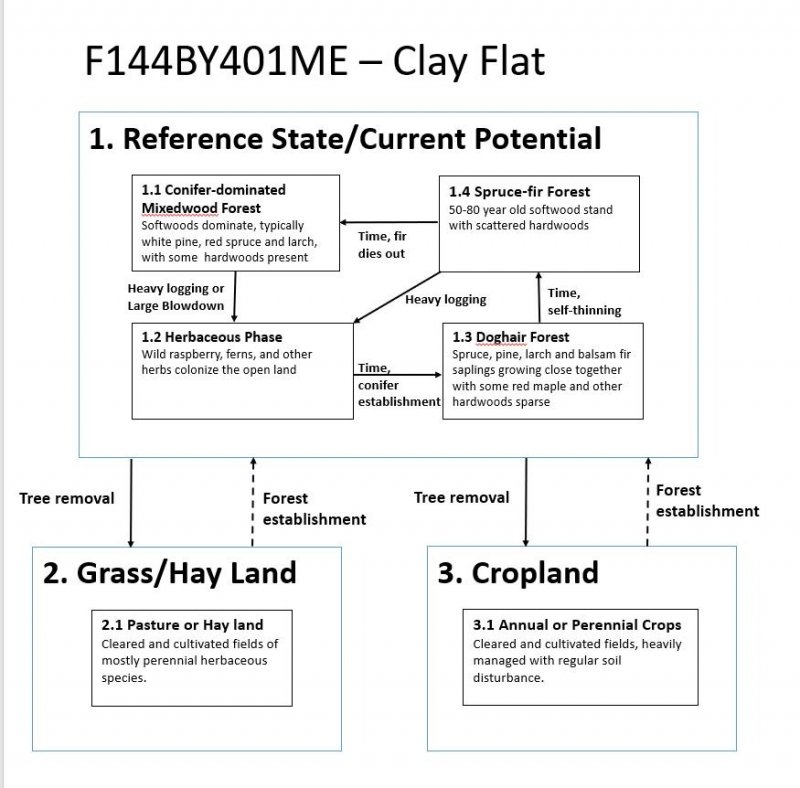
Ecological site concept
This ecological site is found on the frigid, poorly- and somewhat poorly- drained, non-acidic, glaciomarine or glaciolacustrine deposits in coastal and central interior flat lowland terraces within the major river valleys, or on valley floors behind glacial moraines. This site does not flood or pond, but occurs adjacent to seasonally ponded, very poorly drained sites. The seasonally high “perched” water table is within 18 inches of the surface from October through June. The perched water table with moderate and moderately slow permeability and linear slope shape, typically provides for up to 4 inches of organic matter to accumulate on the surface in forested areas. Some of these areas may have up to eight inches of accumulated organic matter. Non-forested areas typically do not have recognizable organic horizons at the surface due to surface mixing during clearing for agricultural practices.
The reference state is considered a Palustrine forested wetland in the Cowardin Wetland Classification System (Cowardin et al. 1979) and a Mineral Soil Flat in the Hydrogeomorphic (HGM) Wetland Classification System (Brinson, M.M. 1993). At some higher slopes in its range, it may correlate more closely to a slope wetland in the HGM classification system. Due to some micro-relief, pit and mound mostly, this site may occur as a major component of associations and complexes of wetter and drier soils on the landscape, but extensive areas are in consociations as well. The reference plant community is dominantly hydrophytic vegetation; it is transitional to the vegetation of the very poorly drained positions below it and the upland positions above it. Large white pine and quaking aspen, common on abandoned farmland in river valleys, are often found on this site and are upland species considered relics of a previously cleared state.
Associated sites
| F144BY402ME |
Clay Hills The somewhat poorly- and poorly-drained Clay Flat site often occurs downslope of the moderately well- and well-drained Clay Hills site |
|---|---|
| F144BY304ME |
Wet Clay Flat The very poorly- and poorly-drained Wet Clay Flat site may occur downslope of the poorly- and somewhate poorly- Clay Flat site |
Similar sites
| F144BY304ME |
Wet Clay Flat The very poorly- and poorly-drained Wet Clay Flat site may occur downslope of the poorly- and somewhate poorly- Clay Flat site. |
|---|---|
| F144BY402ME |
Clay Hills The somewhat poorly- and poorly-drained Clay Flat site often occurs downslope of the moderately well- and well-drained Clay Hills site |
Table 1. Dominant plant species
| Tree |
(1) Pinus strobus |
|---|---|
| Shrub |
Not specified |
| Herbaceous |
Not specified |
Click on box and path labels to scroll to the respective text.