Natural Resources
Conservation Service
Ecological site F144BY402ME
Clay Hills
Last updated: 9/27/2024
Accessed: 04/06/2026
General information
Provisional. A provisional ecological site description has undergone quality control and quality assurance review. It contains a working state and transition model and enough information to identify the ecological site.
MLRA notes
Major Land Resource Area (MLRA): 144B–New England and Eastern New York Upland, Northern Part
This major land resource area (MLRA) is in Maine (56 percent), New Hampshire (22 percent), Vermont (14 percent), Massachusetts (6 percent), Connecticut (1 percent), and New York (1 percent). It makes up about 22,728 square miles (58,864 square kilometers). The MLRA consists of a relatively young landscape shaped by the Laurentide Ice Sheet, which covered the region from 35,000 to 10,000 years ago. Rolling hills of dense basal till converge on ridges of shallow bedrock that were scoured by glacial ice. River valleys that were flooded by melting glacial water or seawater house large expanses of glacial outwash and stratified drift in inland areas and, to a lesser extent, glaciomarine and glaciolacustrine sediment deposits in coastal areas. Organic bogs, ablation till, and alluvial flood plains make up the remaining portions of the MLRA.
The soils in this region are dominantly Entisols, Spodosols, and Inceptisols. They commonly have a fragipan. The dominant suborders are Ochrepts, Orthods, Aquepts, Fluvents, and Saprists. The soils in the region dominantly have a frigid soil temperature regime with some cryic areas at higher elevation, a udic soil moisture regime, and mixed mineralogy. Most of the land is forested, and 98 percent is privately owned. Significant amounts of forest products are produced including lumber, pulpwood, Christmas trees, and maple syrup. Principal agricultural crops include forage and grains for dairy cattle, potatoes, apples, and blueberries. Wildlife habitat and recreation are important land uses. Stoniness, steep slopes, and poor drainage limit the use of many of the soils.
Classification relationships
NRCS:
Land Resource Region: R—Northeastern Forage and Forest Region
MLRA: 144B—New England and Eastern New York Upland, Northern PartMLRA resources
Major Land Resource Area (MLRA): 144B–New England and Eastern New York Upland, Northern Part
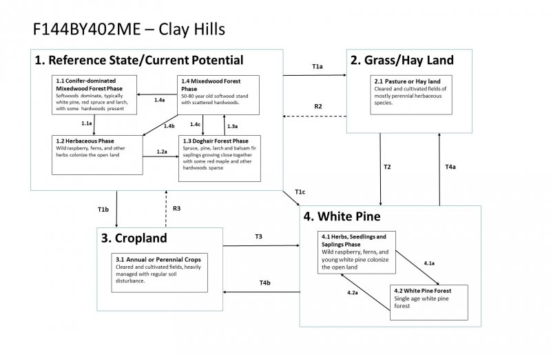
Ecological site concept
This site occurs on the remnants of gently-sloping (0-15%) glacial lake beds, lake plains and terraces. Soils have clay textures and very few rock fragments throughout the profile. These are moderately-well and well drained soils with a seasonally-high water table within 18-36 inches of the soil surface. Tree species are diverse, typically with conifers such as red spruce, larch, and white pine more abundant than hardwoods, which include red maple and grey birch.
Associated sites
| F144BY301ME |
Loamy Till Swamp The Loamy Till Swamp site occurs lower in the watershed than the Loamy Flat site. The two sites occur together along a soil drainage gradient from somewhat poorly to poorly- and very poorly-drained. |
|---|---|
| F144BY502ME |
Loamy Till Toeslope The Loamy Flat site and Loamy Till Toeslopes site share many of the same soils, but Loamy Flats occur on flatter areas grading into wetlands and produce spruce-fir forests, whereas the Loamy Till Toeslope occurs at the base of slopes and produces semi-rich mixedwood forests. |
| F144BY304ME |
Wet Clay Flat The Loamy Flat site occurs on somewhat-poorly and poorly-drained soil complexes that are somewhat drier and have significantly less understory production than the Wet Loamy Flat site. |
Similar sites
| F144BY502ME |
Loamy Till Toeslope The Loamy Flat site and Loamy Till Toeslopes site share many of the same soils, but Loamy Flats occur on flatter areas grading into wetlands and produce spruce-fir forests, whereas the Loamy Till Toeslope occurs at the base of slopes and produces semi-rich mixedwood forests. |
|---|---|
| F144BY304ME |
Wet Clay Flat The Loamy Flat site occurs on somewhat-poorly and poorly-drained soil complexes that are somewhat drier and have significantly less understory production than the Wet Loamy Flat site. |
Table 1. Dominant plant species
| Tree |
(1) Pinus strobus |
|---|---|
| Shrub |
Not specified |
| Herbaceous |
Not specified |
Click on box and path labels to scroll to the respective text.