Natural Resources
Conservation Service
Ecological site F144BY507ME
Semi-rich Till Toeslope
Last updated: 9/27/2024
Accessed: 04/06/2026
General information
Provisional. A provisional ecological site description has undergone quality control and quality assurance review. It contains a working state and transition model and enough information to identify the ecological site.
MLRA notes
Major Land Resource Area (MLRA): 144B–New England and Eastern New York Upland, Northern Part
This major land resource area (MLRA) is in Maine (56 percent), New Hampshire (22 percent), Vermont (14 percent), Massachusetts (6 percent), Connecticut (1 percent), and New York (1 percent). It makes up about 22,728 square miles (58,864 square kilometers). The MLRA consists of a relatively young landscape shaped by the Laurentide Ice Sheet, which covered the region from 35,000 to 10,000 years ago. Rolling hills of dense basal till converge on ridges of shallow bedrock that were scoured by glacial ice. River valleys that were flooded by melting glacial water or seawater house large expanses of glacial outwash and stratified drift in inland areas and, to a lesser extent, glaciomarine and glaciolacustrine sediment deposits in coastal areas. Organic bogs, ablation till, and alluvial flood plains make up the remaining portions of the MLRA.
The soils in this region are dominantly Entisols, Spodosols, and Inceptisols. They commonly have a fragipan. The dominant suborders are Ochrepts, Orthods, Aquepts, Fluvents, and Saprists. The soils in the region dominantly have a frigid soil temperature regime with some cryic areas at higher elevation, a udic soil moisture regime, and mixed mineralogy. Most of the land is forested, and 98 percent is privately owned. Significant amounts of forest products are produced including lumber, pulpwood, Christmas trees, and maple syrup. Principal agricultural crops include forage and grains for dairy cattle, potatoes, apples, and blueberries. Wildlife habitat and recreation are important land uses. Stoniness, steep slopes, and poor drainage limit the use of many of the soils.
Classification relationships
NRCS:
Land Resource Region: R—Northeastern Forage and Forest Region
MLRA: 144B—New England and Eastern New York Upland, Northern Part
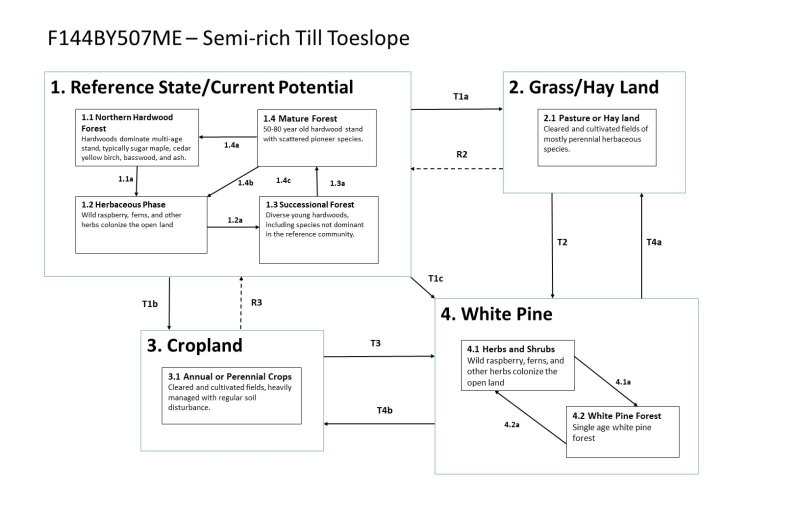
Ecological site concept
This site occurs on deep, poorly- to somewhat poorly-drained loam soils derived from calcareous bedrock. Bedrock is greater than 20 inches below the mineral soil surface. This site is found on footslope and toeslope positions that receive additional water and nutrients from higher areas of the watershed. The vegetation is characterized by northern hardwoods, particularly sugar maple, basswood, ash, and northern white cedar. These are productive soils with some rich site indicators in the understory, including blue cohosh, Christmas fern, and royal fern. These soils are often farmed.
Associated sites
| F144BY230ME |
Acidic Peat Wetland Complex The Loamy Till Swamp site occurs lower in the watershed than the Semi-rich Till Toeslope site. The two sites occur together along a soil drainage gradient from somewhat poorly to poorly- and very poorly-drained. |
|---|---|
| F144BY507ME |
Semi-rich Till Toeslope The Semi-rich Till Toeslope site usually occurs downslope, on wetter, richer soils than the Semi-rich Till Slope. |
Similar sites
| F144BY502ME |
Loamy Till Toeslope The Semi-rich Till Toeslope site has similar soil texture and wetness, but is distinguished by higher soil nutrients derived from calcareous parent material (such as limestone), as evidenced by high soil pH and rich site indicator species (particularly basswood). |
|---|---|
| F144BY506ME |
Semi-rich Till Slope The Semi-rich Till Toeslope site usually occurs downslope, on wetter, richer soils than the Semi-rich Till Slope. |
| F144BY504ME |
Enriched Loamy Cove While both sites have rich site indicators, the Enriched Loamy Cove site occurs along drainageways, is well-drained, lacks calcareous parent material, and has a thick dark soil surface horizon. By contrast, the Semi-rich Till Toeslope occurs at the base of calcareous slopes and is poorly- to somewhat poorly-drained. These two sites produce very similar communities. |
Table 1. Dominant plant species
| Tree |
(1) Acer saccharum |
|---|---|
| Shrub |
Not specified |
| Herbaceous |
Not specified |
Click on box and path labels to scroll to the respective text.