Natural Resources
Conservation Service
Ecological site F149BY003MA
Well Drained Lake Plain
Last updated: 9/09/2024
Accessed: 04/03/2026
General information
Provisional. A provisional ecological site description has undergone quality control and quality assurance review. It contains a working state and transition model and enough information to identify the ecological site.
MLRA notes
Major Land Resource Area (MLRA): 149B–Long Island-Cape Cod Coastal Lowland
149B—Long Island-Cape Cod Coastal Lowland
This area is in the Embayed Section of the Coastal Plain Province of the Atlantic Plain. It is part of the partially submerged coastal plain of New England. It is mostly an area of nearly level to rolling plains, but it has some steeper hills (glacial moraines). Ridges border the lower plains. The Peconic and Carmans Rivers are on the eastern end of Long Island. The parts of this area in Massachusetts and Rhode Island have no major rivers. This entire area is made up of deep, unconsolidated glacial outwash deposits of sand and gravel. A thin mantle of glacial till covers most of the surface. Some moraines form ridges and higher hills in this area of generally low relief. Sand dunes and tidal marshes are extensive along the coastline.
Classification relationships
USDA-NRCS (USDA, 2006):
Land Resource Region (LRR): S—Northern Atlantic Slope Diversified Farming Region
Major Land Resource Area (MLRA): 149B—Long Island-Cape Cod Coastal Lowland
USDA-FS (Cleland et al., 2007):
Province: 221 Eastern Broadleaf Forest Province
Section: 221A Lower New England
Subsection: 221Ab Cape Cod Coastal Lowland and Islands
Subsection: 221An Long Island Coastal Lowland and Moraine
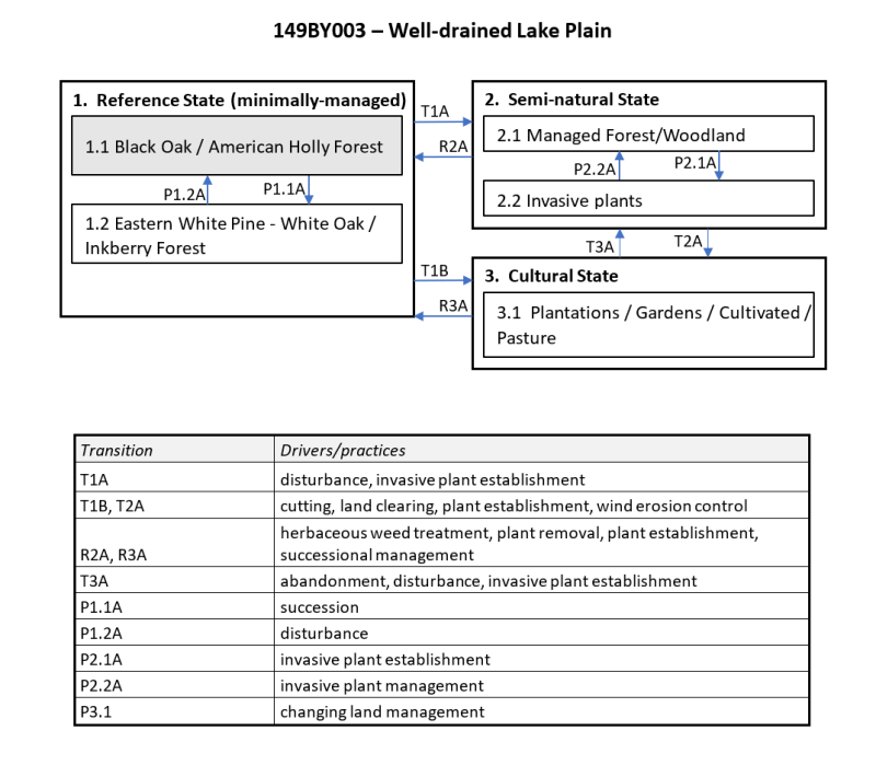
Ecological site concept
The site consists of deep, well-drained sandy material underlain by silty lacustrine deposits on level plains. Representative soil is Hinesburg.
The reference community is a “coastal forest/woodland” (Swain and Kearsley 2011). Occurring in protected areas along the coast, these forests are predominately oaks with red maple and white pine. Coastal forests also may include more southern species such as American Holly, honeylocust, blacklocust, black gum, and sassafras.
Associated sites
| F149BY003MA |
Well Drained Lake Plain Wet Lake Plain |
|---|
Similar sites
| F149BY009MA |
Well Drained Dense Till Uplands Well-drained Dense Till |
|---|
Table 1. Dominant plant species
| Tree |
(1) Quercus velutina |
|---|---|
| Shrub |
(1) Ilex opaca |
| Herbaceous |
(1) Thelypteris noveboracensis |
Click on box and path labels to scroll to the respective text.