Natural Resources
Conservation Service
Ecological site F149BY007NY
Moist Outwash
Last updated: 9/17/2024
Accessed: 02/08/2026
General information
Provisional. A provisional ecological site description has undergone quality control and quality assurance review. It contains a working state and transition model and enough information to identify the ecological site.
MLRA notes
Major Land Resource Area (MLRA): 149B–Long Island-Cape Cod Coastal Lowland
149B—Long Island-Cape Cod Coastal Lowland
This area is in the Embayed Section of the Coastal Plain Province of the Atlantic Plain. It is part of the partially submerged coastal plain of New England. It is mostly an area of nearly level to rolling plains, but it has some steeper hills (glacial moraines). Ridges border the lower plains. The Peconic and Carmans Rivers are on the eastern end of Long Island. The parts of this area in Massachusetts and Rhode Island have no major rivers. This entire area is made up of deep, unconsolidated glacial outwash deposits of sand and gravel. A thin mantle of glacial till covers most of the surface. Some moraines form ridges and higher hills in this area of generally low relief. Sand dunes and tidal marshes are extensive along the coastline.
Classification relationships
USDA-NRCS (USDA, 2006):
Land Resource Region (LRR): S—Northern Atlantic Slope Diversified Farming Region
Major Land Resource Area (MLRA): 149B—Long Island-Cape Cod Coastal Lowland
USDA-FS (Cleland et al., 2007):
Province: 221 Eastern Broadleaf Forest Province
Section: 221A Lower New England
Subsection: 221Ab Cape Cod Coastal Lowland and Islands
Subsection: 221An Long Island Coastal Lowland and Moraine
Ecological site concept
This site consists of very deep, moderately well drained soils on outwash plains. These soils formed in a thin mantle of loamy outwash deposits overlying stratified sand and gravel. Representative soils are Mineola.
Many of the plant communities are considered maritime if influenced by salt spray from coastal storms or coastal if only influenced by the coastal climate. The representative plant communities are varied but consist largely of oaks (chestnut, black, scarlet, and white), and occasional pines (pitch, white) and red maple e.g., “oak- tuliptree forest” (Edinger et al. 2014); “coastal oak / holly forest” (Edinger et al. 2014); “coastal oak-beech forest” (Edinger et al. 2014); “maritime oak /holly” (Edinger et al. 2014); “maritime post oak forest” (Edinger et al. 2014); plus open sites include “maritime grassland” (Edinger et al. 2014); These sites are very similar to the well-drained counterpart, but are typically more diverse. Influences include development, drought, fire, and invasive plants like winged Euonymous and Asiatic bittersweet.
Associated sites
| F149BY006NY |
Well Drained Outwash Well-drained Outwash |
|---|---|
| F149BY008MA |
Very Wet Outwash Wet Outwash |
Similar sites
| F149BY010MA |
Moist Till Uplands Moist Till Upland |
|---|
Table 1. Dominant plant species
| Tree |
(1) Quercus velutina |
|---|---|
| Shrub |
(1) Ilex opaca |
| Herbaceous |
Not specified |
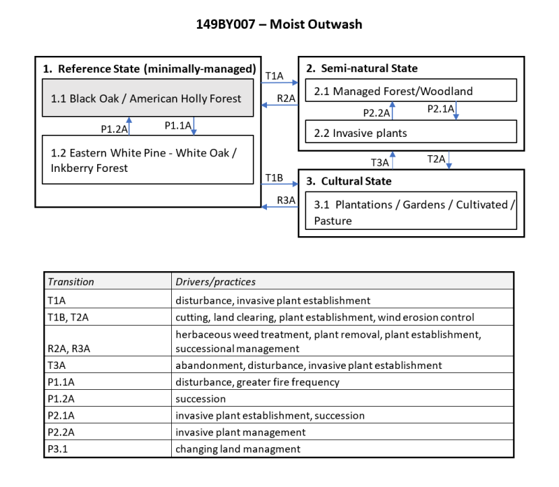
Click on box and path labels to scroll to the respective text.
