Natural Resources
Conservation Service
Ecological site R155XY170FL
Sandy Coastal Grasslands and Forests
Last updated: 4/14/2025
Accessed: 04/10/2026
General information
Provisional. A provisional ecological site description has undergone quality control and quality assurance review. It contains a working state and transition model and enough information to identify the ecological site.
MLRA notes
Major Land Resource Area (MLRA): 155X–Southern Florida Flatwoods
This MLRA makes up about 19,973 square miles (51,731 square kilometers) and is entirely in Florida. It stretches across the mid-section of the State, from the Gulf of America to the Atlantic Ocean, and north and south from the Everglades (MLRA 156A) to Jacksonville. This MLRA consists of a young sandy marine plain of Pleistocene age that is underlain by Tertiary-age limestone bedrock. The terrain is nearly level to gently sloping with large areas of swamp and marsh. Sinkholes affect land use and management.
The landscape consists of nearly level to gently sloping marine terraces that have large areas of wetlands and marshes. Streams and lakes are common. Low-lying wet areas are flat with some hummocks that rise 3 feet (1 meter) above the general level of the landscape. Coastal areas consist of low beach ridges and dunes that rise 6 to 10 feet (2 to 3 meters) above the lower inland areas. Elevation ranges from sea level to less than 196 feet (60 meters), increasing gradually from the coast to inland areas.
This MLRA is underlain by sediments of the Quaternary Period (present to 2.58 million years ago) which overlie Neogene (2.53 to 23.03 million years ago) and Paleogene (23.03 to 66 million years ago) formations, including those of the Hawthorn Group. The older rocks are exposed in the north-central part of this area. The Quaternary sediments are largely undifferentiated marine deposits consisting of fine to coarse sands that are poorly to moderately sorted with variable admixtures of clay and organic material. Undifferentiated Holocene (present to 0.0117 million years ago) sediments, which include quartz sands, marls, organic material, and minor carbonate sands and mud, are in the northeast part of this MLRA. The sediments may also include freshwater gastropods. Near the southeastern coastline, the Anastasia Formation and Miami Limestone are exposed. The Anastasia Formation is made up of a variably lithified coquina of shells and sands and unlithified fossiliferous sand. The Miami Limestone is white to light gray, variably fossiliferous, oolitic and pelletal with variable percentages of quartz sand, ranging from sandy limestone to calcareous quartz sand (Scott, 1993a, 1993b; Duncan, 1993a, 1993b). Quaternary beach ridge and dune sediments, which are mapped based on topographic expression, occur throughout the MLRA, becoming more abundant toward the coast.
The average annual precipitation is 38 to 61 inches (973 to 1,559 millimeters). About 60 percent of the precipitation occurs from June through September. Most of the rainfall occurs during moderate-intensity, tropical storms that produce large amounts of rain from late spring through early autumn. Late autumn and winter are relatively dry. The average annual temperature is 69 to 76 degrees F (21 to 24 degrees C). The freeze-free period averages 335 days and ranges from 300 to 365 days.
The dominant soil orders are Alfisols, Entisols, and Spodosols. The soils in the area dominantly have a hyperthermic temperature regime, an aquic moisture regime, and siliceous mineralogy. They generally are deep or very deep; poorly drained, very poorly drained, or somewhat poorly drained; and sandy or loamy, or both. Anthroportic soils throughout the area are a result of cut-and-fill activities associated with construction and urbanization.
This area supports flatwood forest vegetation. Slash pine, longleaf pine, loblolly pine, cabbage palm, bald cypress, laurel oak, water oak, and live oak are the main species. Saw palmetto, wax myrtle, gallberry, and grasses such as bluestems, threeawns, maidencane, and wiregrasses characterize the understory. Along the coastline and around the city of Orlando, this MLRA has been heavily urbanized. However, a significant acreage remains in agriculture for the production of citrus, specialty crops, and cattle. Surface water runoff from agriculture and urbanization are carefully monitored to help mitigate sinkhole development.
The major soil resource concerns are wind erosion, maintenance of the content of organic matter and productivity of the soils, and management of soil moisture. Conservation practices on cropland generally include conservation crop rotations, cover crops, irrigation water management (including micro irrigation systems), nutrient management, and pest management. Conservation practices on pasture and rangeland generally include prescribed grazing, brush management, pest management, prescribed burning, and watering facilities. Conservation practices on forestland generally include forest stand improvement, forest site preparation, prescribed burning, firebreaks, establishment of trees and shrubs, pest management, and management of upland wildlife habitat.
Classification relationships
All portions of the geographical range of this site falls under the following ecological / land classifications including:
-Environmental Protection Agency’s Level 3 and 4 Ecoregions of Florida: 75 Southern Coastal Plain; 75b Southwestern Florida Flatwoods,75d Eastern Florida Flatwoods (Griffith, G. E., Omernik, J. M., & Pierson, S. M., 2013)
-Florida Natural Area Inventory, 2010 Edition: Coastal Uplands; Coastal Grasslands, Coastal Inundated Swale, Coastal Berm, Maritime Hammock (FNAI ,2010)
-Soil Conservation Service, 26 Ecological Communities of Florida: 1- North Florida Coastal Strand, 2- South Florida Coastal Strand, 14- Tropical Hammocks (Florida Chapter Soil and Water Conservation Society, 1989)
-LandFire Existing Vegetation Type, 2020: Southeastern Ruderal Grassland, Southeastern Florida Coastal Strand Shrubland, Southern Coastal Plain Oak Dome and Hammock, Southwest Florida Dune and Coastal Grasslands.
LandFire Biophysical Setting, 2020: Southwest Florida Coastal Strand and Maritime Hammock
-Myers and Ewel, 1990: Dunes and maritime hammocks – transition zone, Maritime Hammock
Ecological site concept
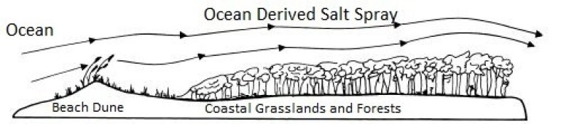
This ecological site is associated with very deep somewhat poorly to moderately well drained sandy soils that exist behind active dune systems along the Florida coastline. These are found in greatest extent on barrier islands and capes along both the Atlantic and gulf coasts. This site often develops behind active beach dunes relying on the protection from intense sand burial and salt spray. This protection allows for the establishment of grasslands behind the dune system that support both salt and freshwater species.
Reference plant community 1.1 is primarily composed of open grasslands often large in size, narrow in width, running parallel along coastal beaches. These graminoids are well adapted to salt spray and sand burial and are able to readily re-colonize following disturbances. Disturbances that break through the protective barrier that supports these sites such as over wash and burial will often reset these areas to open bare sand until the seedbank present meets the correct conditions for growth. Without natural disturbances, the reference conditions may become encroached by salt tolerant woody species, and may transition to a closed canopy forest over time. These areas are highly urbanized due to desirable location in coastal communities and highly susceptible to degradation via foot traffic. This site may be split into two separate ecological site descriptions with future projects addressing saline influence on soil-vegetation dynamics.
Associated sites
| R155XY020FL |
Haline Intertidal Marshes and Swamps These sites are very poorly drained communities that occur in lower, wetter, intertidal landscape positions. These will occur in sheltered lower-wave energy coastlines along the backside of barrier islands not exposed to salt spray. |
|---|---|
| R155XY070FL |
Sandy Freshwater Isolated Marshes and Swamps These sites are very poorly drained communities that occur in lower, wetter, undulating landscape positions within the associated site. These will occur as poorly defined drainageways within the associated site formed by overwash during periods of extreme storm events. |
| R155XY220FL |
Sandy Coastal Beach Dunes These sites are excessively drained communities that occur in higher, drier, coastal landscape positions. These will occur immediately adjacent to the Atlantic Ocean or gulf, protecting the associated site found immediately behind them. |
| R155XY230FL |
Sandy Scrub on Ridges, Knolls, and Dunes of Xeric Uplands These sites are excessively drained communities that occur in higher, drier, coastal landscape positions. These will occur as stabilized coastal scrub communities, a relict dune system within the associated site. |
Similar sites
| F155XY200FL |
Shallow to Moderately Deep Sandy over Loamy Maritime Forests These sites have similar vegetative community composition and structure but will occur along more stabilized coastlines altered for human production. Soils materials will have fine textures at shallower depths and different bedrock (coquina), affecting the production of vegetation in both natural and altered states. |
|---|---|
| F155XY210FL |
Deep Sandy over Loamy Maritime Forests These sites have similar vegetative community composition and structure but will occur along more stabilized coastlines altered for human production. Soils materials will have fine textures and different bedrock (coquina), affecting the production of vegetation in both natural and altered states. |
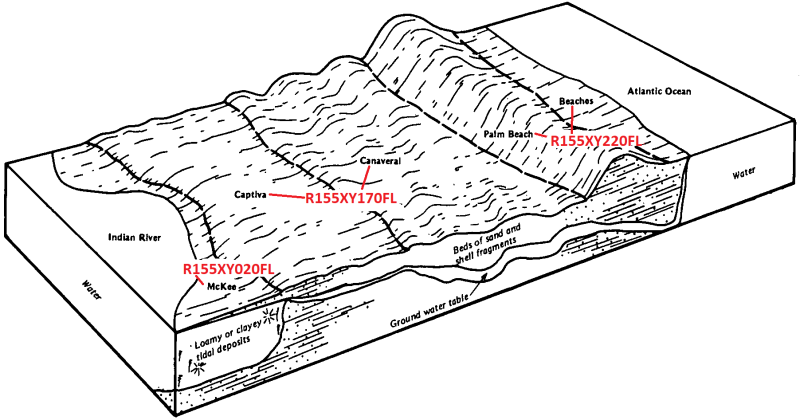
Figure 1. R155XY170FL is dependent on the formation and protection of coastal dunes(R155XY220FL), and will often boarder intertidal marshes and swamps (R155XY020FL) along protected shorelines from high energy action
Table 1. Dominant plant species
| Tree |
(1) Quercus virginiana |
|---|---|
| Shrub |
(1) Serenoa repens |
| Herbaceous |
(1) Spartina patens |
Click on box and path labels to scroll to the respective text.
Ecosystem states
| T1A | - | Community Destroying Disturbance Event |
|---|---|---|
| T1B | - | Introduction and Establishment of Invasive / Non-Native / Undesirable Species |
| T1C | - | Human Alteration and Human Transportation of Soils Materials |
| R2A | - | Vegetation Establishment |
| T2A | - | Human Alteration and Human Transportation of Soils Materials |
| R3A | - | Invaded / Non-Native/ Undesirable Species Removal and Restoration |
| T3A | - | Human Alteration and Human Transportation of Soils Materials |
State 1 submodel, plant communities
| 1.1A | - | Shrubland Establishment through Ecological Succession |
|---|---|---|
| 1.2A | - | Forest Establishment through Ecological Succession |
| 1.3A | - | Overstory Mortality (Not Storm Surge Related) |
| 1.3B | - | Storm Surge Deposition (Saline Intrusion) |
| 1.4A | - | Secondary Succession |
State 2 submodel, plant communities
State 3 submodel, plant communities
State 4 submodel, plant communities
| 4.1A | - | Urbanization |
|---|---|---|
| 4.2A | - | Land Restoration / Reclamation |
| 4.2B | - | Industrialization / Urbanization to Non-Reclaimed Lands |
| 4.3A | - | Land Restoration / Reclamation |