
Major Land Resource Area 155X
Southern Florida Flatwoods
Accessed: 04/10/2026
Description
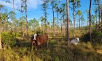
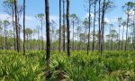
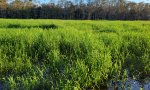
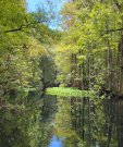
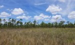
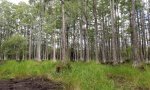
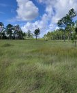
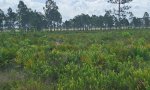
MLRA 155, Southern Florida Flatwoods, makes up about 19,973 square miles (51,731 square kilometers) and is entirely in Florida. It stretches across the mid-section of the State, from the Gulf of Mexico to the Atlantic Ocean, and north and south from the Everglades (MLRA 156A) to Jacksonville. This MLRA consists of a young sandy marine plain of Pleistocene age that is underlain by Tertiary-age limestone bedrock. The terrain is nearly level to gently sloping with large areas of swamp and marsh. Sinkholes affect land use and management. MLRA 155 is extensively intertwined with MLRA 154 across the western mid-section of Florida. These two MLRAs differ slightly based on elevation and depth to limestone bedrock. As depth to bedrock decreases, sinkhole formation and the accumulation of surface waters into water bodies increase. MLRA 155 surrounds MLRA 156B, which occurs as a pocket of significantly wetter, low-lying wetland with a diffuse boundary. To the south, MLRA 155 borders MLRA 156A, which has distinctly different use and management and an isohyperthermic soil temperature regime. Along the coastline and around the city of Orlando, this MLRA has been heavily urbanized. However, a significant acreage remains in agriculture for the production of citrus, specialty crops, and cattle. Surface water runoff from agriculture and urbanization are carefully monitored to help mitigate sinkhole development. The forestland in this area consists mainly of low-quality pine. It is grazed extensively. More than one-third of the area is improved pasture or native range grazed by cattle. The cropland is reserved for many kinds of winter vegetables. Some citrus fruits are grown. Other subtropical fruits are grown in the southern part of the MLRA. The major soil resource concerns are wind erosion, maintenance of the content of organic matter and productivity of the soils, and management of soil moisture. Conservation practices on cropland generally include conservation crop rotations, cover crops, irrigation water management (including micro irrigation systems), nutrient management, and pest management. Conservation practices on pasture and rangeland generally include prescribed grazing, brush management, pest management, prescribed burning, and watering facilities. Conservation practices on forestland generally include forest stand improvement, forest site preparation, prescribed burning, firebreaks, establishment of trees and shrubs, pest management, and management of upland wildlife habitat.
Key publications
Next steps
-
1
Select an ecological site
Select an ecological site using the list, keys, photos, briefcase, or quick search option located on this page. -
2
Explore the ecological site description
Next, learn more about the selected ecological site and its characteristic dynamics by browsing the ecological site description and exploring alternative state and transition model formats.
Ecological site list
-
i
Key Characteristics
- Terrestrial sites not occurring along coastline landscapes
- Site not occurring along major rivers and streams, or if it does occur near major rivers and streams it is not influenced by regular flooding events (even in the absence of water control structures)
- Soils very poorly and/ or poorly drained
- Site occurs on flats or flatwoods
- 40 inches to ≥ 80 inches of fine sand or sand and a spodic horizon, an argillic horizon below 40 inches, or both
-
i
Key Characteristics
- Terrestrial sites not occurring along coastline landscapes
- Site not occurring along major rivers and streams, or if it does occur near major rivers and streams it is not influenced by regular flooding events (even in the absence of water control structures)
- Soils very poorly and/ or poorly drained
- Site occurs on flats or flatwoods
- Fine sand or sand over an argillic horizon between 20 inches to 40 inches
-
i
Key Characteristics
- Terrestrial sites not occurring along coastline landscapes
- Site not occurring along major rivers and streams, or if it does occur near major rivers and streams it is not influenced by regular flooding events (even in the absence of water control structures)
- Soils very poorly and/ or poorly drained
- Site occurs on flats or flatwoods
- Argillic horizon within 20 inches of the soil surface
-
 ProvisionalF155XY150FL/F155XY150FLSandy Flatwoods and Hammocks on Rises and Knolls of Mesic Uplandsi
Key Characteristics
- Terrestrial sites not occurring along coastline landscapes
- Site not occurring along major rivers and streams, or if it does occur near major rivers and streams it is not influenced by regular flooding events (even in the absence of water control structures)
- Soils somewhat poorly and/ or moderately well drained
- Site occurs in low landscape rises or knolls
- 40 inches to ≥ 80 inches of fine sand or sand and a spodic horizon, an argillic horizon below 40 inches, or both
-
ProvisionalF155XY160FL/F155XY160FLSandy over Loamy Flatwoods and Hammocks on Rises and Knolls of Mesic Uplandsi
Key Characteristics
- Terrestrial sites not occurring along coastline landscapes
- Site not occurring along major rivers and streams, or if it does occur near major rivers and streams it is not influenced by regular flooding events (even in the absence of water control structures)
- Soils somewhat poorly and/ or moderately well drained
- Site occurs in low landscape rises or knolls
- Fine sand or sand over an argillic horizon between 20 inches to 40 inches
-
i
Key Characteristics
- Terrestrial sites occurring along coastline landscapes
- Site not occurring in intertidal areas and do not experience regular very frequent tidal flooding
- Soils well and/ or excessively well drained
- Site occurs on ridges
- Soils have coquinoid limestone between 20 to 40 inches
-
i
Key Characteristics
- Terrestrial sites occurring along coastline landscapes
- Site not occurring in intertidal areas and do not experience regular very frequent tidal flooding
- Soils well and/ or excessively well drained
- Site occurs on ridges
- Soils have coquinoid limestone deeper than 40
-
i
Key Characteristics
- Terrestrial sites occurring along coastline landscapes
- Site occurring in intertidal areas and experiences regular very frequent tidal flooding
-
i
Key Characteristics
- Terrestrial sites not occurring along coastline landscapes
- Site occurring along major rivers and streams and experiences regular frequent flooding, or would in the absence of water control structures
- 40 inches to ≥ 80 inches of fine sand or sand and a spodic horizon, an argillic horizon below 40 inches, or both
-
i
Key Characteristics
- Terrestrial sites not occurring along coastline landscapes
- Site occurring along major rivers and streams and experiences regular frequent flooding, or would in the absence of water control structures
- Fine sand or sand over an argillic horizon between 20 inches to 40 inches
-
i
Key Characteristics
- Terrestrial sites not occurring along coastline landscapes
- Site occurring along major rivers and streams and experiences regular frequent flooding, or would in the absence of water control structures
- Argillic horizon within 20 inches of the soil surface
-
i
Key Characteristics
- Terrestrial sites not occurring along coastline landscapes
- Site occurring along major rivers and streams and experiences regular frequent flooding, or would in the absence of water control structures
- Organic material throughout or organic material (histic epipedon) over sandy, loamy, or clayey deposits
-
i
Key Characteristics
- Terrestrial sites not occurring along coastline landscapes
- Site not occurring along major rivers and streams, or if it does occur near major rivers and streams it is not influenced by regular flooding events (even in the absence of water control structures)
- Soils very poorly and/ or poorly drained
- Site occurs on concave depressional areas consisting of multiple plant communities
- 40 inches to ≥ 80 inches of fine sand or sand and a spodic horizon, an argillic horizon below 40 inches, or both
-
i
Key Characteristics
- Terrestrial sites not occurring along coastline landscapes
- Site not occurring along major rivers and streams, or if it does occur near major rivers and streams it is not influenced by regular flooding events (even in the absence of water control structures)
- Soils very poorly and/ or poorly drained
- Site occurs on concave depressional areas consisting of multiple plant communities
- Fine sand or sand over an argillic horizon between 20 inches to 40 inches
-
i
Key Characteristics
- Terrestrial sites not occurring along coastline landscapes
- Site not occurring along major rivers and streams, or if it does occur near major rivers and streams it is not influenced by regular flooding events (even in the absence of water control structures)
- Soils very poorly and/ or poorly drained
- Site occurs on concave depressional areas consisting of multiple plant communities
- Argillic horizon within 20 inches of the soil surface
-
i
Key Characteristics
- Terrestrial sites not occurring along coastline landscapes
- Site not occurring along major rivers and streams, or if it does occur near major rivers and streams it is not influenced by regular flooding events (even in the absence of water control structures)
- Soils very poorly and/ or poorly drained
- Site occurs on concave depressional areas consisting of multiple plant communities
- Organic material throughout or organic material (histic epipedon) over sandy, loamy, or clayey deposits
-
i
Key Characteristics
- Terrestrial sites not occurring along coastline landscapes
- Site not occurring along major rivers and streams, or if it does occur near major rivers and streams it is not influenced by regular flooding events (even in the absence of water control structures)
- Soils very poorly and/ or poorly drained
- Site occurs on seepage slopes
-
i
Key Characteristics
- Terrestrial sites occurring along coastline landscapes
- Site not occurring in intertidal areas and do not experience regular very frequent tidal flooding
- Soils somewhat poorly and/ or moderately well drained
-
i
Key Characteristics
- Terrestrial sites not occurring along coastline landscapes
- Site not occurring along major rivers and streams, or if it does occur near major rivers and streams it is not influenced by regular flooding events (even in the absence of water control structures)
- Soils somewhat poorly and/ or moderately well drained
- Site occurs in high landscape rises, knolls, or ridges
-
i
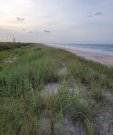
Key Characteristics
- Terrestrial sites occurring along coastline landscapes
- Site not occurring in intertidal areas and do not experience regular very frequent tidal flooding
- Soils well and/ or excessively well drained
- Site occurs on beach dunes
-
i
Key Characteristics
- Terrestrial sites not occurring along coastline landscapes
- Site not occurring along major rivers and streams, or if it does occur near major rivers and streams it is not influenced by regular flooding events (even in the absence of water control structures)
- Soils well drained or better

Ecological site map
Basemap
Find me
Find point
Full screen
Zoom in to display soil survey map units for an area of interest, and zoom out to display MLRAs. Select a map unit polygon to view ecological sites correlated to that map unit. View a brief description of an ecological site by clicking on its name in the map popup. Soil survey correlations may not be accurate, and ecological site classification of a location should always be verified in the field. Each selection may require the transfer of several hundred KB of data.
Ecological site keys
Ecological site photos
Print Options
Sections
Font
Other
Briefcase
Add ecological sites and Major Land Resource Areas to your briefcase by clicking on the briefcase (![]() ) icon wherever it occurs. Drag and drop items to reorder. Cookies are used to store briefcase items between browsing sessions. Because of this, the number of items that can be added to your briefcase is limited, and briefcase items added on one device and browser cannot be accessed from another device or browser. Users who do not wish to place cookies on their devices should not use the briefcase tool. Briefcase cookies serve no other purpose than described here and are deleted whenever browsing history is cleared.
) icon wherever it occurs. Drag and drop items to reorder. Cookies are used to store briefcase items between browsing sessions. Because of this, the number of items that can be added to your briefcase is limited, and briefcase items added on one device and browser cannot be accessed from another device or browser. Users who do not wish to place cookies on their devices should not use the briefcase tool. Briefcase cookies serve no other purpose than described here and are deleted whenever browsing history is cleared.
Ecological sites
Major Land Resource Areas
The Ecosystem Dynamics Interpretive Tool is an information system framework developed by the USDA-ARS Jornada Experimental Range, USDA Natural Resources Conservation Service, and New Mexico State University.