State 1
Reference Plant Community
This state describes the reference community and its successional stages due to changes in fire frequency. The reference community 1.1 is composed of evergreen shrubs, with or without a canopy of pines, with open patches of bare sand and sparse herbs.
Community 1.1
Pine-Oak Scrub Woodland
This community is the reference community.
This community correlates with the Florida Natural Area Inventory Community "Scrub" (FNAI, 2010).
Forest overstory. Where present, sand pines (Pinus clausa) will form an open to dense even-aged stand with a canopy of less than 20% to more than 50% cover. Other pine species including slash pine (P. elliottii) and longleaf pine (P. taeda) may be present in some communities.
Forest understory. The understory is dominated primarily by scrubby oaks consisting of myrtle oak (Quercus myrtifolia), sand live oak (Q. geminata), and Chapman’s oak (Q. chapmanii), and other shrubs such as rusty staggerbush (Lyonia ferruginea) and saw palmetto (Serenoa repens) may be present. Fetterbush (Lyonia lucida), Florida rosemary (Ceratiola ericoides), and scrub oak (Q. inopina) may also be present. These shrubs will often form a dense cover interspersed with patches of bare sand (10 to 50%) and a sparse cover of herbs, primarily pineland threeawn (Aristida stricta), hairsedges (Bulbostylis spp.), and sandyfield beaksedge (Rhynchospora megalocarpa), as well as subshrubs such as pinweeds (Lechea spp.) and jointweeds (Polygonella spp.), and ground lichens (Cladonia leporina, C. prostrata, Cladina subtenuis, and C. evansii).
Dominant plant species
-
sand pine (Pinus clausa), tree
-
slash pine (Pinus elliottii), tree
-
longleaf pine (Pinus palustris), tree
-
myrtle oak (Quercus myrtifolia), shrub
-
sand live oak (Quercus geminata), shrub
-
Chapman oak (Quercus chapmanii), shrub
-
sandhill oak (Quercus inopina), shrub
-
saw palmetto (Serenoa repens), shrub
-
scrub palmetto (Sabal etonia), shrub
-
rusty staggerbush (Lyonia ferruginea), shrub
-
fetterbush lyonia (Lyonia lucida), shrub
-
sand heath (Ceratiola ericoides), shrub
-
pineland threeawn (Aristida stricta), grass
-
hairsedge (Bulbostylis), grass
-
sandyfield beaksedge (Rhynchospora megalocarpa), grass
-
Evans' reindeer lichen (Cladina evansii), other herbaceous
-
reindeer lichen (Cladina subtenuis), other herbaceous
-
cup lichen (Cladonia), other herbaceous
Community 1.2
Mature Hardwood Forest
This community describes a mature hardwood evergreen forest formed from long term fire suppression.
This community correlates with the Florida Natural Area Inventory Community "Xeric Hammock" (FNAI, 2010).
Forest overstory. The low closed canopy is dominated by sand live oak (Quercus geminata), although Chapman's oak (Q. chapmanii), turkey oak (Q. laevis), bluejack oak (Q. incana), sand post oak (Q. margaretta), live oak (Q. virginiana) and laurel oak (Q. hemisphaerica) may also be common. An emergent canopy of pine, either sand pine (Pinus clausa), slash pine (P. elliottii), or longleaf pine (P. palustris), may be present. The epiphytes Spanish moss (Tillandsia usneoides) and ballmoss (T. recurvata) are often abundant on overstory trees.
Forest understory. Common understory plants include saw palmetto (Serenoa repens), myrtle oak (Q. myrtifolia), rusty staggerbush (Lyonia ferruginea), fetterbush (L. lucida), sparkleberry (Vaccinium arboreum), deerberry (V. stamineum), black cherry (Prunus serotina), American beautyberry (Callicarpa americana), common persimmon (Diospyros virginiana), scrub palmetto (Sabal etonia), Hercules’ club (Zanthoxylum clava-herculis), wild olive (Osmanthus americanus) or scrub wild olive (O. megacarpus), garberia (Garberia heterophylla), Florida rosemary (Ceratiola ericoides), and yaupon (Ilex vomitoria). The herb layer is generally very sparse or absent but may contain some scattered wiregrass (Aristida stricta var. beyrichiana), sandyfield beaksedge (Rhynchospora megalocarpa), witchgrass (Dichanthelium spp.), or forbs such as sweet goldenrod (Solidago odora). Muscadine (Vitis rotundifolia) and earleaf greenbrier (Smilax auriculata) are common vines.
Dominant plant species
-
sand live oak (Quercus geminata), tree
-
Chapman oak (Quercus chapmanii), tree
-
turkey oak (Quercus laevis), tree
-
bluejack oak (Quercus incana), tree
-
sand post oak (Quercus margaretta), tree
-
live oak (Quercus virginiana), tree
-
sand pine (Pinus clausa), tree
-
slash pine (Pinus elliottii), tree
-
longleaf pine (Pinus palustris), tree
-
saw palmetto (Serenoa repens), shrub
-
myrtle oak (Quercus myrtifolia), shrub
-
rusty staggerbush (Lyonia ferruginea), shrub
-
fetterbush lyonia (Lyonia lucida), shrub
-
farkleberry (Vaccinium arboreum), shrub
-
deerberry (Vaccinium stamineum), shrub
-
black cherry (Prunus serotina), shrub
-
American beautyberry (Callicarpa americana), shrub
-
common persimmon (Diospyros virginiana), shrub
-
scrub palmetto (Sabal etonia), shrub
-
Hercules' club (Zanthoxylum clava-herculis), shrub
-
devilwood (Osmanthus americanus), shrub
-
pineland threeawn (Aristida stricta), grass
-
sandyfield beaksedge (Rhynchospora megalocarpa), grass
-
rosette grass (Dichanthelium), grass
-
muscadine (Vitis rotundifolia), other herbaceous
-
earleaf greenbrier (Smilax auriculata), other herbaceous
-
airplant (Tillandsia), other herbaceous
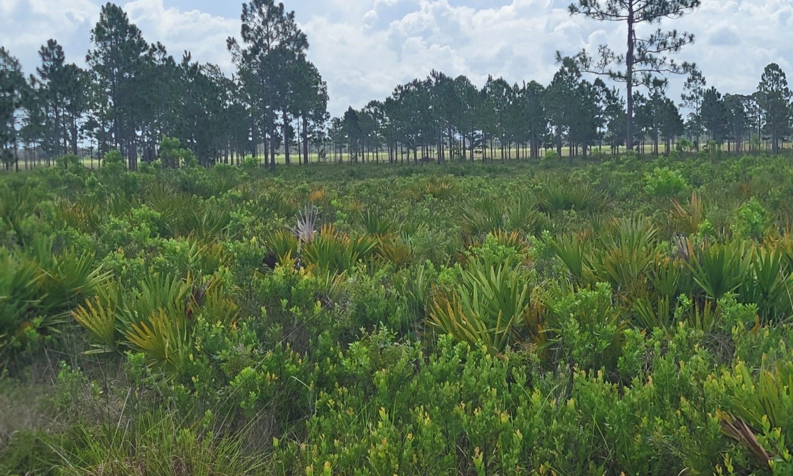
Community 1.3
Early Successional Shrubland

Figure 7. Early successional scrub community dominated by shrubs and herbaceous species.
This community describes an early successional shrubland, without the presence of an overstory due to an unavailable seed source or a seed source that has not yet colonized the stand following a disturbance.
Forest understory. The understory is dominated primarily by scrubby oaks and other fire adapted species related to the reference community, with major changes in community structure of post-fire.
Dominant plant species
-
myrtle oak (Quercus myrtifolia), shrub
-
sand live oak (Quercus geminata), shrub
-
Chapman oak (Quercus chapmanii), shrub
-
sandhill oak (Quercus inopina), shrub
-
saw palmetto (Serenoa repens), shrub
-
scrub palmetto (Sabal etonia), shrub
-
rusty staggerbush (Lyonia ferruginea), shrub
-
fetterbush lyonia (Lyonia lucida), shrub
-
pineland threeawn (Aristida stricta), grass
-
hairsedge (Bulbostylis), grass
-
sandyfield beaksedge (Rhynchospora megalocarpa), grass
-
pinweed (Lechea), other herbaceous
-
jointweed (Polygonella), other herbaceous
-
cup lichen (Cladonia leporina), other herbaceous
-
prostrate cup lichen (Cladonia prostrata), other herbaceous
-
reindeer lichen (Cladina subtenuis), other herbaceous
-
Evans' reindeer lichen (Cladina evansii), other herbaceous
Pathway 1.1A
Community 1.1 to 1.2
This transition is driven by infrequent fires or complete fire suppression from the system allowing for the growth and maturing of understory shrubby / scrub oak species to establish dominance in the overstory. Where sand pines are present, natural mortality after around 70 years may occur, removing the once present overstory of pine species. Longer living pine species such as Florida slash pine or longleaf pine may remain as an emergent canopy but is unlikely to recolonize an area due to high shading of the understory.
Pathway 1.1B
Community 1.1 to 1.3
This transition is driven by a disturbance to the natural community which may remove the overstory and revert back to an early successional shrubland. Disturbances may include frequent fire, along the interval of over 10 to 20 years, allowing for new growth to become established via clonal growth or obligate seeding. Other disturbances may include mechanical removal from clear cutting or from damage in high intensity storm events (hurricanes, tropical storms, etc.), chemical removal of species, or biological removal of overstory species from insect or fungal damage.
Pathway 1.2A
Community 1.2 to 1.1
This transition is driven by the removal of the dominant overstory. This may be done naturally or anthropogenically. Examples of overstory removal may result from clear cutting of a stand, an extreme fire event causing stand replacement, or chemical or biological agents causing mass mortality of overstory species. Once the overstory of oaks has been removed, reintroduction of the natural fire return intervals or a similar management practice should be implemented to maintain desired community structure.
Pathway 1.2B
Community 1.2 to 1.3
This transition is driven by the removal of the dominant overstory due to a stand replacing fire. This may occur in dry periods where fire is allowed to enter the system that would normally exclude fire due to high shade conditions. Fire needs to be intense enough to kill off the root system of the oaks, preventing re-growth from root rhizomes. Large scale disturbances which may be similar to the stand replacing effects of fire may be removal via storm event such as a hurricane, with woody debris remaining in the system.
Pathway 1.3A
Community 1.3 to 1.1
This transition is driven by infrequent fires or complete fire suppression from the system allowing for the growth and maturing of understory shrubby / scrub species. If a pine seedbank is present, species such as sand pine, longleaf pine, or less frequently Florida slash pine, may become established and form an emergent canopy.
State 2
Grazed Rangeland
Rangelands are described as lands on which the indigenous vegetation is predominately grasses, grass-like plants, forbs, and possibly shrubs or dispersed trees. Existing plant communities can include both native and introduced plants. Primary export from Florida ranges are cattle and have been present in the state since their first introduction by Spanish explorers in 1521. Native forage production is very good with proper management in this community, with only a slight effect on the community. Proper management will often result in an increase of grasses and reduction of shrubs while also maintaining proper fire intervals. Rangelands provide a diversity of ecosystems and also provide a diverse and significant production of economic benefits and ecosystem goods and services. Livestock production along with sustainable wildlife populations provide for the major direct economic benefits, but also tourism, recreational uses, minerals/ energy production, renewable energy, and other natural resource uses can be very significant. Vital ecosystem contributions include clean water, clean air, fish/ wildlife habitat, as well as intangible considerations such as historical, cultural, aesthetic and spiritual values. It is strongly advised that consultation with State Resource Conservationist and District Conservationists at local NRCS Service Centers be sought when assistance is needed in developing management recommendations or prescribed grazing practices. This rangeland state correlates with the 1994 Range Site Description 155XY001FL (Sand Pine Scrub).
Community 2.1
Lopsided Indiangrass –Bluestem – Panicum – Threeawns (RSG001 - Excellent)
This phase represents the representative phase of the natural community that has been converted to rangeland in excellent conditions. This phase will have an open canopy with an open to shrubby understory present. In excellent condition lopsided Indiangrass (Sorghastrum secundum), creeping bluestem (Schizachyrium stoloniferum), Purple bluestem (Andropogon glaucopsis), beaked panicum (Panicum anceps), pineland threeawn (Aristida stricta), and sedges (Carex spp.) species will provide the greatest portion of the forage production.
Community 2.2
Wiregrass – Broomsedges - Gallberry – Dwarf Oak (RSG001 – Poor to Fair)
This phase represent the succession of rangeland in excellent condition to poor or fair conditions. The stage of this phase is the transitional period between a managed rangeland to a shrubby rangeland. Duration of this phase is dependent on former and future management, use, and impacts. This poor to fair condition phase will most often consist of the Gallberry (Ilex glabra), wiregrass (Aristida stricta) and a dwarf variety of an oak, dependent on the seedbank present. This phase often transitions due to poor management, including overstocking and overgrazing, as well as mismanagement of the natural habitat. Other undesirable species may be present in this community that have not been mentioned.
Pathway 2.1A
Community 2.1 to 2.2
This pathway occurs when range management activities include overgrazing, overstocking, etc., natural succession of the once managed site leads to this stage.
Pathway 2.2A
Community 2.2 to 2.1
This pathway represents renovation of the unmanaged condition back to managed rangeland in excellent condition. Management activities likely include mechanical removal of the larger, woody vegetation followed by herbicide treatment and establishment of desired seeding mixtures, and correcting grazing management plans.
State 3
Managed Grassland / Pasture
Pasture is a land use type having vegetation cover comprised primarily of introduced or enhanced native forage species that is used for livestock grazing. Pasture vegetation can consist of grasses, legumes, other forbs, shrubs or a mixture. The majority of these forages are introduced, having originally come from areas in other states or continents. Most are now naturalized and are vital components of pasture based grazing systems. Pasture lands provide many benefits other than forage for livestock. Wildlife use pasture as shelter and for food sources. Well managed pasture captures rainwater that is slowly infiltrated into the soil which helps recharge groundwater. Many small pasture livestock operations are near urban areas providing vistas for everyone to enjoy. It is especially important as livestock managers continues to experience extraordinarily high fuel and other input costs. Overgrazed pastures can lead to soil compaction and numerous bare spots, which may then become focal points of accelerated erosion and colonization sites of undesirable plants or weeds. It is strongly advised that consultation with State Resource Conservationist and District Conservationists at local NRCS Service Centers be sought when assistance is needed in developing management recommendations or prescribed grazing practices. This grassland / pastureland state correlates with the 2013 Florida Forage Suitability Group G155XB121FL (Sandy Soils on Rises, Knolls, and Ridges of Mesic Uplands).
Community 3.1
Bahiagrass – Bermudagrass – Bluestem (FSG121)
This community phase represents commonly planted forage species on pasturelands, haylands, and open grasslands found in drained areas of this natural community. The suite of plants established on any given site may vary considerably depending upon purpose, management goals, and usage (e.g., horses vs. cattle). Most systems include a mixture of grasses and legumes that provide forage throughout the growing season. Warm season perennial forage species often include bahiagrass (Paspalum notatum), bermudagrass (Cynodon dactylon), Chalky bluestem (Andropogon virginicus var. glaucus), big bluestem (Andropogon gerardii), splitbeard bluestem (Andropogon ternarius), yellow indiangrass (Sorghastrum nutans), switchgrass (Panicum virgatum), and rhizoma perennial peanut (Arachis glabrata). Warm season annual forage species often include browntop millet (Urochloa ramosa), pearl millet (Pennisetum glaucum), sorghum (Sorghum bicolor, includes forage sorghum, sudangrass, and their hybrids), hairy indigo (Indigofera hirsuta), ayeclover (Alysicarpus vaginalis), and cowpea (Vigna unguiculata). Several additional plants and/ or species combinations maybe present depending on the objectives and management approaches of the land manager/owner.
Resilience management. Seasonal and total forage production is somewhat higher than soils found in similar landscape positions with better drainage because these soils have slightly better water holding capacities and a higher seasonal water table (3 to 5 feet). These factors will decrease drought effects, but total annual production is still driven largely by rainfall. Yields can increase by >1,000 lbs/acre in years with above average rainfall. However, greatly reduced production and even stand loss is associated with over grazing and can occur in years with below average rainfall. Irrigation is not recommended for these soils due to poor water holding capacity. Establishment of both annual and perennial warm season forages may be delayed due to limited rainfall in the spring and short-term drought periods in the summer months.
Cool season forage production is very limited due to decreased and sporadic rainfall during winter months (November - March), therefore no cool season forages are recommended and no production data is given.
Dominant plant species
-
bahiagrass (Paspalum notatum), grass
-
Bermudagrass (Cynodon dactylon), grass
-
purple bluestem (Andropogon glaucopsis), grass
-
big bluestem (Andropogon gerardii), grass
-
splitbeard bluestem (Andropogon ternarius), grass
-
Indiangrass (Sorghastrum nutans), grass
-
switchgrass (Panicum virgatum), grass
-
browntop millet (Urochloa ramosa), grass
-
pearl millet (Pennisetum glaucum), grass
-
sorghum (Sorghum bicolor), grass
-
rhizoma peanut (Arachis glabrata), other herbaceous
-
hairy indigo (Indigofera hirsuta), other herbaceous
-
white moneywort (Alysicarpus vaginalis), other herbaceous
-
cowpea (Vigna unguiculata), other herbaceous
Community 3.2
Dogfennel – Bunchgrass– Wax Myrtle (Unmanaged)
This phase represent the succession of pastureland and/or open grassland to unmanaged conditions. Duration of this phase is dependent on former and future management, use, and impacts. The early pioneer shrub thicket phase will be dependent on the available seedbank present. This unmanaged phase will most often consist of the shrub wax myrtle (Morella cerifera) and dogfennel (Eupatorium capillifolium), an aggressive native perennial that is characteristic of unimproved, unmanaged, or overgrazed pastures, where it adds to the decline of forage yield and quality. Pasture grass present will enter a reproductive phase and have woody stems that are undesirable forage species. Other undesirable species may be present in this community that have not been mentioned.
Pathway 3.1A
Community 3.1 to 3.2
This pathway occurs when pasture management activities include overgrazing, overstocking, etc., natural succession of the once managed site leads to this stage.
Pathway 3.2B
Community 3.2 to 3.1
This pathway represents renovation of the unmanaged condition back to managed grassland / pasture in excellent condition. Management activities likely include mechanical removal of the larger, woody vegetation followed by herbicide treatment and establishment of desired seeding mixtures, and correcting grazing management plans.
State 4
Agricultural Commodities
The agriculture industry includes cultivated crops, aquaculture, and apiculture. Cultivated cropland includes areas used for the production of adapted crops for harvest. These areas comprise of land in row crops or close-grown crops that are in a rotation with row or close-grown crops. Primary exports from Florida consist of fruits, greenhouse and nursery products, sugar cane, and the signature export of citrus. Aquaculture includes the cultivation and maintenance of aquatic plants, aquatic reptiles, crustaceans, food/ ornamental fish, shellfish, and other miscellaneous species for harvesting. Apiculture includes the maintenance of honeybees and hives to provide beeswax, honey/ other edible bee products, crop pollination services, and sales of bees to other beekeepers. These areas have been modified resulting in land clearing practices and hydrologic management to fit the growers needs. It is strongly advised that consultation with State Agronomist and District Conservationists at local NRCS Service Centers be sought when assistance is needed in developing management recommendations.
Resilience management. Major natural resource concerns facing cropland include: (1) erosion by wind and water, (2) maintaining and enhancing soil quality, (3) water quality from nutrient and pesticides runoff and leaching, and (4) managing the quantity of water available for irrigation. For more specific information regarding cropland please contact your local NRCS office.
Community 4.1
Vegetables
This phase describes the growth and harvest of vegetables. Land conversion may be necessary to create fields suitable for crop growth. Common vegetables grown in these soils include Cabbage, Celery, Cucumber, Peppers, Irish Potatoes, Summer Squash, and Tomatoes. Due to the year-round warm climate Florida has, vegetables can often be harvested in both winter and summer seasons.
Resilience management. Selection of species and varieties is critical for vegetable production, as plants that are not adapted to local conditions will generally fail to produce regardless of how much care and attention they receive. Weather is perhaps the single most important factor that determines where crops can be grown. Winters may be too cold for some vegetables or too short for others. Still other crops may suffer from summer's heat and humidity. Consequently, species and varieties should be chosen on the basis of historical weather patterns. It is strongly advised that consultation with State Agronomist and District Conservationists at local NRCS Service Centers be sought when assistance is needed in developing management recommendations.
Community 4.2
Non-Citrus Fruits and Nuts
This phase describes the growth and harvest of fruits. Land conversion may be necessary to create fields suitable for crop growth. Common fruits grown in these soils include Strawberries and Watermelons. Due to the year-round warm climate Florida has, fruits can often be harvested in both winter and summer seasons.
Resilience management. Selection of species and varieties is critical for fruit production, as plants that are not adapted to local conditions will generally fail to produce regardless of how much care and attention they receive. Weather is perhaps the single most important factor that determines where fruit crops can be grown. Winters may be too cold for some fruit or too short for others. Still other fruit may suffer from summer's heat and humidity. Consequently, species and varieties of fruits should be chosen on the basis of historical weather patterns. It is strongly advised that consultation with State Agronomist and District Conservationists at local NRCS Service Centers besought when assistance is needed in developing management recommendations.
Community 4.3
Grasses / Grain Crops
This phase describes the growth and harvest of grass-like agricultural products and grain crops used for silage. Land conversion may be necessary to create fields suitable for crop growth. Common species grown in these soils include Corn, Sweet Corn, Grain Sorghum, Improved Bermudagrass Hay, Sorghum Silage, and Sugarcane. Due to the year-round warm climate Florida has, these species can often be grown and harvested in both winter and summer seasons.
Resilience management. Selection of species and varieties is critical for grass and grain production, as plants that are not adapted to local conditions will generally fail to produce regardless of how much care and attention they receive. Weather is perhaps the single most important factor that determines where fruit crops can be grown. Winters may be too cold for some crops or too short for others. Still other crops may suffer from summer's heat and humidity. Consequently, species and varieties of crop should be chosen on the basis of historical weather patterns. It is strongly advised that consultation with State Agronomist and District Conservationists at local NRCS Service Centers be sought when assistance is needed in developing management recommendations.
Community 4.4
Citrus Fruits
This phase describes the growth of citrus crops, dominantly identified as oranges and grapefruit within this ecological site area. This phase differs from other fruits and tree crops due to the intensive management and care needed for citrus groves. Citrus is one of the highest commercial agriculture products in the state of Florida.
Resilience management. Management should be based off individual groves, as different areas will require different management. It is strongly advised that consultation with State Agronomist and District Conservationists at local NRCS Service Centers be sought when assistance is needed in developing management recommendations.
Community 4.5
Abandoned Agriculture Fields
This phase describes the absence of management from agriculture fields, often resulting in overgrowth of woody shrubs and vines as well as invasive weeds. This community may occur when producers abandon a field due to any number of reasons. Many fields in the first seasons of abandonment will remain fallow until weedy and shrubby species become dominant. With proper management this community has the potential to support agricultural commodities.
Pathway 4.1A
Community 4.1 to 4.2
The conversion from vegetable crops to non-citrus fruit and nut crops would require, if applicable, the harvest of the crop before converting the land for the desired crop production. Mechanical ground preparation and chemical applications may be needed to create the desired land use conditions for the new crop.
Pathway 4.1B
Community 4.1 to 4.3
The conversion from vegetable crops to grasses/ grain crop would require, if applicable, the harvest of the crop before converting the land for the desired crop production. Mechanical ground preparation and chemical applications may be needed to create the desired land use conditions for the new crop.
Pathway 4.1C
Community 4.1 to 4.4
The conversion from vegetable crops to citrus crop would require, if applicable, the harvest of the crop before converting the land for the desired crop production. Mechanical ground preparation and chemical applications may be needed to create the desired land use conditions for the new crop.
Pathway 4.1D
Community 4.1 to 4.5
Many fields become abandoned when a producer doesn't maintain and harvest crops against pests, diseases, rising costs of labor, or any other reason that will lead to field abandonment.
Pathway 4.2A
Community 4.2 to 4.1
The conversion from non-citrus fruit and nut crops to vegetable crops would require, if applicable, the harvest of the crop before converting the land for the desired crop production. Mechanical ground preparation and chemical applications may be needed to create the desired land use conditions for the new crop.
Pathway 4.2B
Community 4.2 to 4.3
The conversion from non-citrus fruit and nut crops to grasses / grain crops would require, if applicable, the harvest of the crop before converting the land for the desired crop production. Mechanical ground preparation and chemical applications may be needed to create the desired land use conditions for the new crop.
Pathway 4.2C
Community 4.2 to 4.4
The conversion from non-citrus fruit and nut crops to citrus crops would require, if applicable, the harvest of the crop before converting the land for the desired crop production. Mechanical ground preparation and chemical applications may be needed to create the desired land use conditions for the new crop.
Pathway 4.2D
Community 4.2 to 4.5
Many fields become abandoned when a producer doesn't maintain and harvest crops against pests, diseases, rising costs of labor, or any other reason that will lead to field abandonment.
Pathway 4.3A
Community 4.3 to 4.1
The conversion from grasses and grain crops to vegetable crops would require, if applicable, the harvest of the crop before converting the land for the desired crop production. Mechanical ground preparation and chemical applications may be needed to create the desired land use conditions for the new crop.
Pathway 4.3B
Community 4.3 to 4.2
The conversion from grasses and grain crops to non-citrus fruit and nut crops would require, if applicable, the harvest of the crop before converting the land for the desired crop production. Mechanical ground preparation and chemical applications may be needed to create the desired land use conditions for the new crop.
Pathway 4.3C
Community 4.3 to 4.4
The conversion from grasses and grain crops to citrus crops would require, if applicable, the harvest of the crop before converting the land for the desired crop production. Mechanical ground preparation and chemical applications may be needed to create the desired land use conditions for the new crop.
Pathway 4.3D
Community 4.3 to 4.5
Many fields become abandoned when a producer doesn't maintain and harvest crops against pests, diseases, rising costs of labor, or any other reason that will lead to field abandonment.
Pathway 4.4A
Community 4.4 to 4.1
The conversion from citrus crops to vegetable crops would require, if applicable, the harvest of the crop before converting the land for the desired crop production. Mechanical ground preparation and chemical applications may be needed to create the desired land use conditions for the new crop.
Pathway 4.4B
Community 4.4 to 4.2
The conversion from citrus crops to non-citrus fruit and nut crops would require, if applicable, the harvest of the crop before converting the land for the desired crop production. Mechanical ground preparation and chemical applications may be needed to create the desired land use conditions for the new crop.
Pathway 4.4C
Community 4.4 to 4.3
The conversion from citrus crops to grasses / grain crops would require, if applicable, the harvest of the crop before converting the land for the desired crop production. Mechanical ground preparation and chemical applications may be needed to create the desired land use conditions for the new crop.
Pathway 4.4D
Community 4.4 to 4.5
Many fields become abandoned when a producer doesn't maintain and harvest crops against pests, diseases, rising costs of labor, or any other reason that will lead to field abandonment. Major diseases affecting citrus groves include citrus canker, an infection that causes lesions on the leaves, stems and fruits of citrus crops, as well as citrus greening, often spread by the Asian citrus psyllid, a sap-sucking hemipteran bug that causes trees to produce fruits that are green, misshapen and bitter, and unsuitable for sale as fresh fruit or juice.
Pathway 4.5A
Community 4.5 to 4.1
The restoration of an abandoned field or grove to an active agriculture field often includes removal of the abandoned crop and weeds, converting the land if necessary, and replanting of desired species. Abandoned citrus groves that get converted to agriculture fields will often need complete removal of the citrus tree and the land to be flattened from furrows present in citrus groves. Once removal of undesirable species is complete and the land is converted to a flat field (if necessary), and new seedlings are planted, maintenance is required to keep the crop healthy until harvest.
Pathway 4.5B
Community 4.5 to 4.2
The restoration of an abandoned field or grove to an active agriculture field often includes removal of the abandoned crop and weeds, converting the land if necessary, and replanting of desired species. Abandoned citrus groves that get converted to agriculture fields will often need complete removal of the citrus tree and the land to be flattened from furrows present in citrus groves. Once removal of undesirable species is complete and the land is converted to a flat field (if necessary), and new seedlings are planted, maintenance is required to keep the crop healthy until harvest.
Pathway 4.5C
Community 4.5 to 4.3
The restoration of an abandoned field or grove to an active agriculture field often includes removal of the abandoned crop and weeds, converting the land if necessary, and replanting of desired species. Abandoned citrus groves that get converted to agriculture fields will often need complete removal of the citrus tree and the land to be flattened from furrows present in citrus groves. Once removal of undesirable species is complete and the land is converted to a flat field (if necessary), and new seedlings are planted, maintenance is required to keep the crop healthy until harvest.
Pathway 4.5D
Community 4.5 to 4.4
The restoration of an abandoned field or grove to an active citrus grove often includes removal of the abandoned crop and weeds and replanting of desired species. In citrus groves removal of abandoned citrus trees are often either completely pulled out of the ground or cut to the stump and new seedlings are planted next to the cut stumps. Once removal of undesirable species is complete and new resets are planted, maintenance is required to keep the crop healthy until harvest.
State 5
Invaded State
This state represents the dominance of one or multiple non-native or exotic species which outcompetes the native natural community and may significantly alter the composition and structure of the invaded stand by overshading the canopy and understory components and preventing regeneration of native species.
Community 5.1
Melaleuca – Brazilian Peppertree
This phase describes the introduction and establishment of invasive species common to this ecological site; Brazilian peppertree (Schinus terebinthifolia) and melaleuca (Melaleuca quinquenervia). These are fire tolerant shrubs (Brazilian peppertree) and trees (Melaleuca) that will outcompete native plants of this ecological site. These species are adapted to the stressors common in scrub systems, including the droughty conditions and frequent fire. Other undesirable species may be present in this community that have not been mentioned.
Resilience management. Restoring native habitat may be very difficult with these species. Specific management plans may be required to identify and manage these species. It is strongly advised that consultation with State Resource Conservationist and District Conservationists at local NRCS Service Centers be sought when assistance is needed in developing management recommendations or invasive control practices.
State 6
Human Altered and Human Transported Areas
These areas include soils that were intentionally and substantially modified by humans for an intended purpose, commonly for terraced agriculture, building support, mining, transportation, and commerce. The alteration is of sufficient magnitude to result in the introduction of a new parent material (human-transported material) or a profound change in the previously existing parent material (human-altered material).They do not include soils modified through standard agricultural practices or farmed soils with unintended wind and water erosion. When a soil is on or above an anthropogenic landform or microfeature, it can be definitely be associated with human activity and is assigned to a unique taxa, usually found as an "Urban land complex" within that communities' natural soil properties (e.g, Daytona fine sand-Urban land complex, 0 to 5 percent slopes).
Characteristics and indicators. Evidence of these areas include soils with manufactured items (e.g. artifacts) present in the profile, human altered-materials (e.g., deeply excavated or deeply plowed soil) or human-transported material (e.g., fill), and position on or above anthropogenic landforms (e.g., flood-control levees) and microfeatures (e.g., drainage ditches). Detailed criteria regarding the identification of anthropogenic (artificial) landforms, human-altered materials, and human-transported material are in the "Keys to Soil Taxonomy" (Soil Survey Staff, 2014).
Community 6.1
Reclaimed Areas
Reclaimed areas are areas that have been modified through anthropogenic means that are restored to a natural or second-hand natural community. Areas that can be reclaimed are any intensity urban areas and may be required to be reclaimed after urban use (e.g., active mines must be reclaimed). These practices include the identification, removal, and stockpiling soil materials before altering the land, and revegetation and replacement of soil materials after altering the land. This also applies to nearby urban areas that have been adversely affected by the anthropogenic activities.
Community 6.2
Urban Areas
This urban community consists of development for human use. Urban areas include a variety of land uses, e.g., inner city or urban core, industrial and residential areas, cemeteries, parks, and other open spaces; the overall function which may benefit the quality of human life. These often form an urban soil mosaic, where the natural landscape has been fragmented into parcels with distinctive disturbance and management regimes and, as a result, distinctive characteristic soil properties.
Resilience management. Within this community there are three different levels of urbanization, based off population dynamics, residential density, and intensity of development. These are labeled as low-intensity, medium-intensity, and high-intensity urban areas, which can eventually be split apart into its own separate state. Low-intensity urban areas may consist of single dwelling homes with little impact on the surrounding community which still somewhat represents the natural community (e.g., represents natural landscape, hydrology, and vegetation) , other examples of this are urban parks, cemeteries, or campgrounds with little urban development. Medium-intensity urban areas consist of larger urban dwellings with some natural features but have been modified to meet urban needs (e.g., towns). High-intensity urban areas are areas of heavily modified areas with complete alterations of the natural landscape, hydrology, and vegetation to support a very large population, which once constructed is permanently altered (e.g., metropolis areas/ active mines).
Community 6.3
Non-Reclaimed Areas
Non-reclaimed areas are areas that have been modified through anthropogenic means that are unable to be restored to a natural or semi-natural community. Areas that cannot be reclaimed are areas under active mining status (phosphate, sand, or gravel mines)or mined areas before the Phosphate Land Reclamation Act in 1975, which leaves shut down operations alone. These areas also include fallow mines that have been flooded and are now permanent bodies of water.
Community 6.4
Landfills
This is an anthropogenic site for the disposal of waste material. It includes manufactured layers (artificial, root limiting layer below the soil surface) that are representative of human altered and human transported sites. These layers are often alternative between natural fill material and geotextile liners, asphalt, concrete, rubber or plastic that are built up and can rise above the surrounding landscape by 30meters or more often impeding water, gas, or roots from moving through the profile.
Pathway 6.1A
Community 6.1 to 6.2
This transition is driven by clearing and developing the land for low-, medium-, or high-intensity urban areas.
Pathway 6.1B
Community 6.1 to 6.4
This transition is driven by the deposition of manufactured layers along with anthropogenic waste which is consistently built upon.
Pathway 6.2A
Community 6.2 to 6.1
This transition is driven by the revegetation, reestablished hydroperiods, and replacement of displaced soil materials after urbanization of the land.
Pathway 6.2B
Community 6.2 to 6.3
This transition is driven by heavy industrial or urban development which causes the land to become non-reclaimable. This transition is rare due to the many environmental laws and regulations that must be followed when developing land.
Pathway 6.2C
Community 6.2 to 6.4
This transition is driven by the deposition of manufactured layers along with anthropogenic waste which is consistently built upon.
Pathway 6.3A
Community 6.3 to 6.1
This transition is driven by the revegetation, reestablished hydroperiods, and replacement of displaced soil materials after urbanization of the land.
Transition T1A
State 1 to 2
This mechanism is driven by the introduction of livestock species to the natural system and implementing a planned grazing strategy. Use of a planned grazing strategy to balance animal forage demand with available forage resources. Timing, duration, and frequency of grazing are controlled and some type of grazing rotation is applied to allow for plant recovery following grazing. It is strongly advised that consultation with State Resource Conservationist and District Conservationists at local NRCS Service Centers be sought when assistance is needed in developing management recommendations or prescribed grazing practices.
Transition T1B
State 1 to 3
Actions required to convert native habitat to pasture or forage production include herbicide application, seedbed preparation, and the establishment of desired plants. Decisions to convert native land to pastureland on this site should be made carefully and continuously evaluated before, during, and after conversion activities. This site is extremely susceptible to soil compaction and erosion. The decision to proceed with this action should be done so in close communication with and guidance from local NRCS Service Centers.
Transition T1C
State 1 to 4
Actions required to convert native habitat to agricultural land include herbicide application, seedbed preparation, and the establishment of desired plants. Decisions to convert native land to agriculture on this site should be made carefully and continuously evaluated before, during, and after conversion activities. The decision to proceed with this action should be done so in close communication with and guidance from local NRCS Service Centers.
Transition T1D
State 1 to 5
This transition represents proliferation and dominance of an invasive species. Soil mechanical disturbances can compound this effect and create suitable conditions for invasive species.
Transition T1E
State 1 to 6
This transition is driven by the alteration and/ or transportation of soil materials via anthropogenic means.
Restoration pathway R2A
State 2 to 1
This mechanism is driven by the removal of livestock species from the naturally grazed system and restoring natural frequent fire intervals to maintain natural community composition and structure.
Transition T2A
State 2 to 3
Actions required to convert altered land use to pasture or forage production include herbicide application, seedbed preparation, and the establishment of desired plants. Decisions to convert to pastureland on this site should be made carefully and continuously evaluated before, during, and after conversion activities. This site is extremely susceptible to soil compaction and erosion. The decision to proceed with this action should be done so in close communication with and guidance from local NRCS Service Centers.
Transition T2B
State 2 to 4
Actions required to convert altered land use to agricultural land include herbicide application, seedbed preparation, and the establishment of desired plants. Decisions to convert land to agriculture on this site should be made carefully and continuously evaluated before, during, and after conversion activities. The decision to proceed with this action should be done so in close communication with and guidance from local NRCS Service Centers.
Transition T2C
State 2 to 5
This transition represents proliferation and dominance of an invasive species. Soil mechanical disturbances can compound this effect and create suitable conditions for invasive species.
Transition T2D
State 2 to 6
This transition is driven by the alteration and/ or transportation of soil materials via anthropogenic means.
Restoration pathway R3A
State 3 to 1
Management practices such as replanting native grasses, shrubs, and trees and prescribed burning must be implemented to return the to the natural state. Local site conditions and disturbances may determine existing plant seed banks and community composition of managed grasslands/ pastures. The decision to proceed with this action should be done so in close communication with and guidance from local NRCS Service Centers.
Transition T3A
State 3 to 4
Actions required to convert altered land use to agricultural land include herbicide application, seedbed preparation, and the establishment of desired plants. Decisions to convert land to agriculture on this site should be made carefully and continuously evaluated before, during, and after conversion activities. The decision to proceed with this action should be done so in close communication with and guidance from local NRCS Service Centers.
Transition T3B
State 3 to 5
This transition represents proliferation and dominance of an invasive species. Soil mechanical disturbances can compound this effect and create suitable conditions for invasive species.
Transition T3C
State 3 to 6
This transition is driven by the alteration and/ or transportation of soil materials via anthropogenic means.
Restoration pathway R4A
State 4 to 1
Management practices such as replanting native grasses, shrubs, and trees and prescribed burning must be implemented to return the to the natural state. Local site conditions and disturbances may determine existing plant seed banks and community composition of managed grasslands/ pastures. The decision to proceed with this action should be done so in close communication with and guidance from local NRCS Service Centers.
Transition T4A
State 4 to 3
Actions required to convert altered land use to pasture or forage production include herbicide application, seedbed preparation, and the establishment of desired plants. Decisions to convert to pastureland on this site should be made carefully and continuously evaluated before, during, and after conversion activities. This site is extremely susceptible to soil compaction and erosion. The decision to proceed with this action should be done so in close communication with and guidance from local NRCS Service Centers.
Transition T4B
State 4 to 5
This transition represents proliferation and dominance of an invasive species. Soil mechanical disturbances can compound this effect and create suitable conditions for invasive species.
Transition T4C
State 4 to 6
This transition is driven by the alteration and/ or transportation of soil materials via anthropogenic means.
Restoration pathway R5A
State 5 to 1
The establishment of, or a return to, natural habitat conditions following a previous invasive / non-native / undesirable species infestation may be possible in some areas. Successful actions will require relentless efforts that include removal of the species via chemical or mechanical or biological means. In some extreme cases, restoration attempts could result in greater erosion and worsening of local conditions. Please consult with District and Soil Conservationists at local NRCS Field Offices for advice and guidance on land restoration attempts on invaded areas.
Restoration pathway R5B
State 5 to 2
The establishment of, or a return to, altered land use conditions following a previous invasive / non-native / undesirable species infestation may be possible in some areas. Successful actions will require relentless efforts that include removal of the species via chemical or mechanical or biological means. In some extreme cases, restoration attempts could result in greater erosion and worsening of local conditions. Please consult with District and Soil Conservationists at local NRCS Field Offices for advice and guidance on land restoration attempts on invaded areas.
Restoration pathway R5C
State 5 to 3
The establishment of, or a return to, altered land use conditions following a previous invasive / non-native / undesirable species infestation may be possible in some areas. Successful actions will require relentless efforts that include removal of the species via chemical or mechanical or biological means. In some extreme cases, restoration attempts could result in greater erosion and worsening of local conditions. Please consult with District and Soil Conservationists at local NRCS Field Offices for advice and guidance on land restoration attempts on invaded areas.
Restoration pathway R5D
State 5 to 4
The establishment of, or a return to, altered land use conditions following a previous invasive / non-native / undesirable species infestation may be possible in some areas. Successful actions will require relentless efforts that include removal of the species via chemical or mechanical or biological means. In some extreme cases, restoration attempts could result in greater erosion and worsening of local conditions. Please consult with District and Soil Conservationists at local NRCS Field Offices for advice and guidance on land restoration attempts on invaded areas.
Transition T5A
State 5 to 6
This transition is driven by the alteration and/ or transportation of soil materials via anthropogenic means.