Natural Resources
Conservation Service
Ecological site R156AY120FL
Subtropical Keys Tidal Rock Barrens of Southern Coast and Islands
Last updated: 4/14/2025
Accessed: 04/03/2026
General information
Provisional. A provisional ecological site description has undergone quality control and quality assurance review. It contains a working state and transition model and enough information to identify the ecological site.
MLRA notes
Major Land Resource Area (MLRA): 156A–Florida Everglades and Associated Areas
This area makes up about 7,749 square miles (20,071 square kilometers) and is entirely in Florida. It is located at the southern tip of the State and has shoreline on both the Atlantic Ocean and the Gulf of America. Lake Okeechobee borders the MLRA to the north. Aside from sugar cane plantations in the north, the Everglades National Park, Big Cypress National Preserve, and the Big Cypress Seminole Indian Reservation comprise this area. Historical ditching, berming, and canals prevent natural water flow through this delicate ecosystem. To mitigate this, extensive restoration efforts have been implemented. Urban sprawl from Miami and cities to its north on the Atlantic Ridge has encroached along the eastern boundary of this area. Most of the MLRA has resisted urbanization because of a water table that is at or near the surface, a considerable acreage of unstable organic soils, and its identity as a national treasure.
About one-third of this area is in Native American reservations, national parks, game refuges, or other large holdings. Cypress forests are extensive in the area, but mangrove forests are widespread along the eastern and southern coasts. A large part of the area is open marsh. Much of the area is used for hunting, fishing, and other recreational activities. The cropland in the area is used mainly for winter vegetables, but citrus fruits, avocado, and papaya are grown on the better drained soils. Sugarcane is an important crop on the organic soils south of Lake Okeechobee. The acreage of improved pasture is increasing. Beef cattle are the principal kind of livestock, but dairying is an important enterprise locally. Urbanization is extensive along the eastern coast.
The major soil resource concerns are wind erosion, maintenance of the content of organic matter and productivity of the soils, and management of soil moisture and soil subsidence. Conservation practices on cropland generally include conservation crop rotations, cover crops, nutrient management, pest management, water-control structures, surface drainage systems (field ditches, mains, and laterals), pumping plants, and irrigation water management (including micro irrigation systems and surface and subsurface irrigation systems). Conservation practices on pasture and rangeland generally include prescribed grazing, brush management, pest management, prescribed burning, and watering facilities. Conservation practices on forestland generally include forest stand improvement, firebreaks, pest management, prescribed burning, and management of upland and wetland wildlife habitat.
LRU notes
There is not an official LRU for the MLRA 156A area. For the time being the technical team recommended to add the four terrestrial physiographic provinces ecoregions (Big Cypress, Everglades, Southern Coast and Islands, and Miami Ridge / Atlantic Coastal Strip) and one subaqueous ecoregion (Coastal Marine and Estuarine) on this section. This PES occurs within the Southern Coast and Island ecoregion.
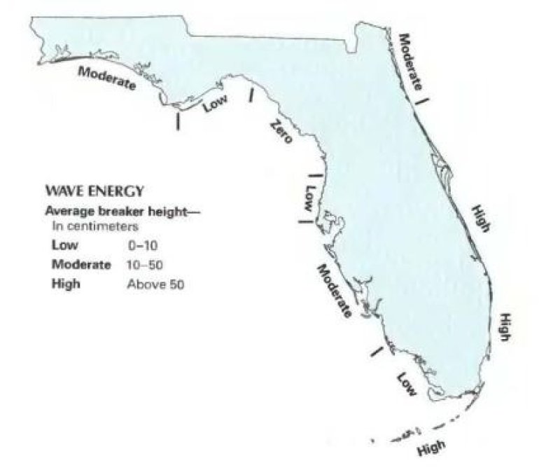
The Southern Coast and Islands Ecoregion, 5 m and below (17 ft and below) in elevation and includes the Ten Thousand Islands and Cape Sable, the islands of Florida Bay, and the Florida Keys. It is an area of mangrove swamps and coastal marshes, coral reefs, various coastal strand type vegetation on beach ridge deposits and limestone rock islands. Although freshwater habitats are limited or non-existent in this region, any freshwater that does occur for periods of time may have great ecological significance. Coastal rockland lakes are small and number, occurring primarily in the Florida Keys. These waters are alkaline, with high mineral content and highly variable salinity levels. The rockland lakes provide important habitat for several kinds of fish, mammals, and birds of the Keys. Reductions in the fresh groundwater lens that floats on the denser saline groundwater can severely affect these lakes.
Classification relationships
All portions of the geographical range of this site falls under the following ecological / land classifications including:
-Environmental Protection Agency's Level 3 and 4 Ecoregions of Florida: 76 Southern Florida Coastal Plain; 76D Southern Coast and Islands (Griffith, G. E., Omernik, J. M., & Pierson, S. M., 2013)
-Florida Natural Area Inventory, 2010 Edition: Marine and Estuarine Vegetative Wetlands; Keys Tidal Rock Barren (FNAI ,2010)
Ecological site concept
The Subtropical Keys Tidal Rock Barren of Southern Coast and Islands ecological community occurs in flat, wet, supratidal coastal zones along relatively low energy coastlines. These are rocky scrub soils without continuous cover with much exposed and eroded white limestone at the surface. The main sources of water are from the ocean, where saltwater reduces competition of freshwater species, and from rainfall and runoff from adjacent uplands, which flushes salt from the site and delivers nutrients. The Keys Tidal Rock Barren only exists within the Florida Keys found upon Key Largo Limestone in the Upper Keys and Miami Limestone in the Lower Keys. These communities help protect other inland communities by absorbing the brunt of tropical storms and hurricanes and by mitigating coastal erosion. The major threat to this ecological site is sea level rise, which is replacing these saltwater tolerant communities with coastal wetlands such as salt marshes and mangrove swamps, sites that are more adapted to frequent flooding. This ecological site is very fragile and maintains high ecological diversity.
Associated sites
| F156AY130FL |
Subtropical Forested Rocklands of Southern Coast and Islands The Subtropical Forested Rocklands of Southern Coast and Islands occurs in slightly higher landscape positions, and may grade into this community as marl and sand become more abundant. This site will support the growth of more upland terrestrial species on thin soils that are not influenced by tidal regimes. |
|---|---|
| R156AY110FL |
Subtropical Tidal Saline Wetlands of Southern Coast and Islands The Subtropical Tidal Saline Wetlands of Southern Coast and Islands occurs in slightly lower terrestrial landscape positions, and may grade into this community due to pneumatophores ability to trap herbaceous material and create its own highly organic sediment for new seedlings to propagate on. In depressions within the Tidal Rock Barrens where organic matter has accumulated this site may be present as small inclusions. |
Table 1. Dominant plant species
| Tree |
(1) Rhizophora mangle |
|---|---|
| Shrub |
(1) Conocarpus erectus |
| Herbaceous |
(1) Leucanthemum vulgare |

Click on box and path labels to scroll to the respective text.
Ecosystem states
| T1A | - | Human Alteration / Transportation of Materials |
|---|---|---|
| T1B | - | Increase in Long-Term Hydroperiod |
| T2A | - | Increase in Long-Term Hydroperiod |
State 1 submodel, plant communities
| 1.1A | - | Sediment Accumulation / Species Development |
|---|
State 2 submodel, plant communities
| 2.1A | - | Urban Development |
|---|---|---|
| 2.2B | - | Land Reclamation |
| 2.2B | - | Industrial / Urban Development |
| 2.3A | - | Land Reclaimation |
State 3 submodel, plant communities
| 3.1A | - | Permanent Flooding |
|---|