Ecological dynamics
The information presented in this ecological site description (ESD) and state-and-transition model (STM) were developed using archaeological and historical information, published and unpublished scientific reports, professional experience, consultation with technical experts, and NRCS inventories and studies. The information presented represents a complex set of plant community dynamic and environmental variables. Not all scenarios or plants are represented and included. Key indicator plants, animals, and ecological processes are described to help guide land management decisions and actions.
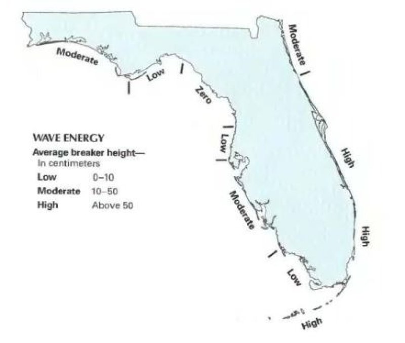
Despite the broad variation of natural vegetation compositional and structure, the unifying features of this PES are frequent flooding and high saline environments occurring in low energy coastal areas. Both are affected by flooding regimes dominated by either astronomical tides or meteorological tides and are subject to zonation based on tidal flooding influence, soil salinity, temperature and elevation.
We have identified two major community variants within this ecological site:
1. Salt Marsh - - Salt marsh is a largely herbaceous community that occurs in the portion of the coastal zone affected by tides and seawater and protected from large waves, either by the broad, gently sloping topography of the shore, by a barrier island, or by location along a bay or estuary. Salt marsh may have distinct zones of vegetation, each dominated by a single species of grass or rush. More halophytic species dominates the seaward edge and borders of tidal creeks, areas most frequently inundated by the tides. The landward edge of the marsh is influenced by freshwater influx from the uplands and may be colonized by a mixture of high marsh and inland species. A border of salt-tolerant shrubs often marks the transition to upland vegetation or low berms along the seaward marsh edge.
Salt marshes are found in flat, protected waters usually within the protection of a barrier island, estuarine system, or along other protected and low-energy coastlines. Salt marshes have gradual slopes of 0 to 1% that determine the extent of the intertidal zone, with gentle slopes reducing wave energy and providing greater areas for plants to colonize. Slopes too flat can cause poor surface drainage resulting in pooling and high salinities, preventing the establishment of seedlings and inhibiting plant growth. Whereas slopes too steep can promote erosion and the transport of fine-grained sediments from uplands to marsh areas. Situated between the land and the sea, salt marshes experience the effects of both salt and fresh water. As tide water’s flood over a marsh, suspended sediment settles out and accumulates around the stems of plants. Rivers and other upland sources also contribute sediments to the marsh by continually transporting and redepositing sediment. Tidal flushing is important in maintaining the exchange of saline waters in salt marshes, with oligotrophic conditions leading to invasion of cattails while hypersaline conditions can stress plants and inhibit growth or cause plant death. Within the salt marsh community there are four major community types resulting from different elevations and geographic differences, they are: Salt pans, intertidal marshes, grassy salt marshes, and buttonwood transitions.
Flooding frequency and soil salinity are the two major environmental factors that influence salt marsh vegetation. Needle rush and saltmarsh cordgrass both tolerate a wide range of salinities, but cordgrass is found where the marsh is flooded almost daily, whereas needle rush is found where the marsh is flooded less frequently. Saltmarsh cordgrass dominates the low marsh (portion below mean high water level), whereas needle rush occupies the high marsh (portion above mean high water level). Both species tend to form taller stands along tidal creeks where salinity is lower and shorter stands where salinity is higher. Salt marshes are very biologically productive communities as well, but greater biomass is usually produced at lower salinities (10 to 20 parts per thousand [ppt]), with marsh salinity ranging from 0.5 ppt to that of seawater (35 ppt) normally but can fluctuate due to high or low tide levels. The base of the food chain is supplied not only by the rooted plant matter, but also by algae and detritus found on the stems of plants, on the sediment surface, and suspended in the water column of pools and tidal creeks.
Natural disturbances on salt marshes include fires, storms and hurricanes, drought, and floods. These events usually have a short-term, localized effect on salt marsh habitat and the community is generally able to recover fairly quickly. When these disturbances occur closely together, or are coupled with human induced impacts, the effects can be catastrophic to the salt marsh community. Fires usually do not permanently affect salt marshes but may temporally affect soil composition, species composition and biomass. Natural fires occurs sporadically in salt marshes, either by spreading from nearby uplands or from lightning strikes in the marsh itself and are limited by natural barriers such as tidal creeks and salt pans. Most salt marshes are affected by the storm surge more than the flooding or strong winds caused by tropical storms. One of the most significant impacts to salt marshes from hurricanes is the potential for rapid invasion of exotic vegetation into disturbed areas, like Australian pine (Casurina equisetifolia) and Brazilian pepper (Schinus terebinthifolius). Sea-level change is an important long-term influence on all salt marshes. Depending on the rate and extent of local sea-level change, salt marsh systems will respond differently. If rates of sea-level rise are slow, some salt marsh vegetation will migrate upward and inland and grow without much change in composition. If rates are too high, the salt marsh may be overgrown by other species, particularly mangroves, or converted to open bodies of water. If there is no accretion of inorganic sediment or peat, the seaward portions of the salt marsh become flooded so that marsh grass drowns and marsh soils erode; portions of the high marsh become low marsh; and adjacent upland areas are flooded at spring tide, becoming high marsh.
2. Mangrove Swamps- A dense forest occurring along relatively flat, low wave energy, marine and estuarine shorelines. The dominant plants of mangrove swamp are red mangrove (Rhizophora mangle), black mangrove (Avicennia germinans), white mangrove (Laguncularia racemosa), and buttonwood (Conocarpus erectus). Mangrove swamps often exist with no understory, although shrubs such as seaside oxeye (Borrichia arborescens, B. frutescens) and vines including gray nicker (Caesalpinia bonduc), coinvine (Dalbergia ecastaphyllum), and rubbervine (Rhabdadenia biflora), and herbaceous species such as saltwort (Batis maritima), shoregrass (Monanthochloe littoralis), perennial glasswort (Sarcocornia perennis), and giant leather fern (Acrostichum danaeifolium), where present, occur most commonly in openings and along swamp edges.
These four mangrove species can occur either in mixed stands or often in differentiated, monospecific zones that reflect varying degrees of tidal influence, levels of salinity, and types of substrate. Red mangrove often dominates the lowest (or deep-water) zone, followed by black mangrove in the intermediate zone, and white mangrove and buttonwood in the highest, least tidally influenced zone. Buttonwood often occupies an ecotone, or transition zone, to the adjacent upland community. The density and height of mangroves and the diversity of associated herbaceous species can vary considerably within a mangrove swamp. Mangroves typically occur in dense stands but may be sparse, particularly in upper tidal reaches where salt marsh species predominate. Mangroves may range from trees more than 80 feet (25 m) tall to dwarf shrubs growing on solid limestone rock, but most commonly exist at intermediate heights of 10 to 20 feet tall (3 to 7 m). Within the mangrove community there are seven major community types resulting from different landform position, these are: Overwash mangrove forests, Fringe mangrove forests, Riverine mangrove forests, Basin mangrove forests, Hammock forests, Scrub or dwarf forests, and Buttonwood forests (Odum et al., 1982).
Temperature, salinity, tidal fluctuation, substrate, and wave energy are five physical factors influencing the size and extent of mangrove swamps. Mangroves require an average annual water temperature above 66F (19C) to survive. They do not tolerate temperatures below freezing or temperatures that fluctuate widely over the course of a year. Mangroves are facultative halophytes; they do not require saltwater for growth but are able to tolerate high salinity and outcompete vascular plants that do not have similar salt tolerances. Mangroves have adapted to saltwater environments by either excluding or excreting salt from plant tissues. These specializations allow mangroves to flourish in a competition-free habitat where other woody plants are excluded by their sensitivity to salt. These species utilize a variety of mechanisms to maintain suitable salt balance, including salt-exclusion, where freshwater is separated at the root via reverse osmosis, and salt-secretion, where salt glands on the leaf surface excrete excess salt (Odum et al.,1982). While they can survive and grow in freshwater, mangroves are usually not found in large stands under such conditions in nature because they succumb to competition. Water fluctuations, both fresh- and salt-water, help shape mangrove swamp systems. Freshwater, through runoff from adjacent uplands or from rivers, flushes salt from the swamp and delivers needed nutrients, while tidewaters push mangrove propagules landward and reduce competition by freshwater species. However, reducing estuarine salinity by increasing freshwater inputs and flushing chemical pollutants from adjacent uplands have resulted in the destruction of some mangrove swamp areas and the invasion by non-mangrove and non-native species. This community is sensitive to colonization by exotic species such as Brazilian pepper (Schinus terebitnthifolius), carrotwood (Cupaniopsis anacardioides), seaside mahoe (Thespesia populnea), latherleaf (Colubrina asiatica), and Australian pine (Casuarina equisetifolia).
The long-lived floating red mangrove propagules are dispersed by water and require a relatively short time for root development allowing them to establish quickly in new areas. The prop-roots of red mangroves, the extensive pneumatophores (aerial roots) of black mangroves, and the dense root mats of the white mangrove help to trap sediments and organic litter and recycle nutrients both from upland areas and from tidal import. This process is an effective means of stabilizing land in coastal environments as well as providing substrate for the attachment of, and shelter for, numerous marine and estuarine organisms. This, along with the continuous shedding of mangrove leaves and other plant components, produce as much as 80 percent of the total organic material available in the aquatic food web. Though mangrove swamps help protect other inland communities by absorbing the brunt of tropical storms and hurricanes and by preventing coastal erosion, these storm events and periodic freezing temperatures have an influence on the stature of mangrove species and generally drive succession within mangrove swamps. Often when canopy damage is incurred following a storm event, new mangrove propagules regenerate in their place. Mangrove swamps are especially vulnerable to climate change impacts such as rising sea levels and the increasing intensity and frequency of tropical weather systems. Mangrove forests differ from other vegetative communities in not experiencing traditional succession and instead experience replacement succession as a function of sea level rise, pushing towards inland communities. Waves along high energy coastlines discourage mangrove establishment and reduce anaerobic sediment accumulation, in which mangroves thrive.
Unconsolidated Substrate are also an important habitat within this ecosite. Characterized as expansive, relatively open areas of subtidal, intertidal, and supratidal zones which lack dense populations of sessile plant and animal species, Unconsolidated Substrates are unsolidified material and include coralgal, marl, mud, mud/sand, sand or shell. Unconsolidated Substrates are important in that they form the foundation for the development of other Marine and Estuarine Natural Communities when conditions become appropriate. Unconsolidated Substrate Communities are associated with and often grade into Mangrove Swamps or Salt Marshes in this ecosite. This is a highly fluctuating community and is altered by storm events, with numerous management plans that include beach reestablishment and coastal stabilization projects. Unconsolidated sediments can originate from organic sources, such as decaying plant tissues (e.g., mud) or from calcium carbonate depositions of plants or animals (e.g., coralgal, marl and shell substrates). Marl and coralgal substrates are primarily restricted to the southern portion of the state. These communities are typically seen as tidal or mud flats and have high contents of acid sulfates.
State 1
Salt Marsh
These are largely herbaceous communities that occurs in the portion of the coastal zone affected by tides and seawater and protected from large waves, either by the broad, gently sloping topography of the shore, by a barrier island, or by location along a bay or estuary. Salt marsh may have distinct zones of vegetation, each dominated by a single species of grass or rush. More halophytic species dominates the seaward edge and borders of tidal creeks, areas most frequently inundated by the tides. The landward edge of the marsh is influenced by freshwater influx from the uplands and may be colonized by a mixture of high marsh and inland species. A border of salt-tolerant shrubs often marks the transition to upland vegetation or low berms along the seaward marsh edge. The following communities are mentioned separately due to their slight differences in different landscape positions. These often grade into one another but many times can not transition to one another.
Characteristics and indicators. These are characteristic of grasses and herbaceous species directly adjacent to a saline or brackish body of water with large layers of undecayed organic material.
Dominant plant species
-
eastern baccharis (Baccharis halimifolia), shrub
-
saltwater false willow (Baccharis angustifolia), shrub
-
Jesuit's bark (Iva frutescens), shrub
-
Carolina desert-thorn (Lycium carolinianum), shrub
-
smooth cordgrass (Spartina alterniflora), grass
-
gulf cordgrass (Spartina spartinae), grass
-
needlegrass rush (Juncus roemerianus), grass
-
fimbry (Fimbristylis), grass
-
Jamaica swamp sawgrass (Cladium mariscus ssp. jamaicense), grass
-
saltmeadow cordgrass (Spartina patens), grass
-
sand cordgrass (Spartina bakeri), grass
-
hurricanegrass (Fimbristylis cymosa), grass
-
lavender thrift (Limonium carolinianum), other herbaceous
-
perennial saltmarsh aster (Symphyotrichum tenuifolium), other herbaceous
-
wand lythrum (Lythrum lineare), other herbaceous
-
shoreline seapurslane (Sesuvium portulacastrum), other herbaceous
-
tree seaside tansy (Borrichia arborescens), other herbaceous
-
narrowleaf yellowtops (Flaveria linearis), other herbaceous
-
seaside heliotrope (Heliotropium curassavicum var. obovatum), other herbaceous
Dominant resource concerns
-
Bank erosion from streams, shorelines, or water conveyance channels
-
Subsidence
-
Organic matter depletion
-
Concentration of salts or other chemicals
-
Ponding and flooding
-
Salts transported to surface water
-
Plant productivity and health
-
Plant structure and composition
Community 1.1
Intertidal Marshes
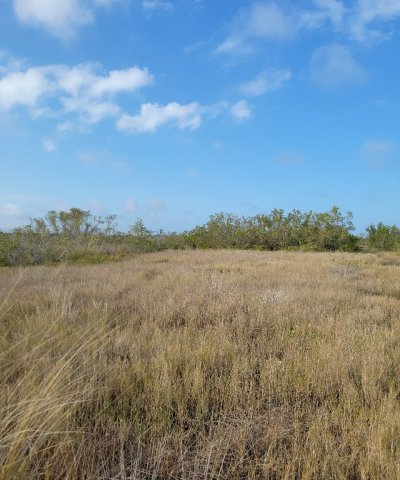
Figure 9. Intertidal marsh that is influenced by periodic tides.
This community is found in the lowest elevation zone consisting primarily of halophytic species of herbs and grasses. This zone is flooded by daily tidal fluctuations.
Community 1.2
Salt Pans

Figure 10. Salt pan dominated by halophytic species.

Figure 11. Glasswort spp.
Also known as salt flats, these are bare, exposed, or water-filled depressions in a salt marsh, often covered by thin layers of blue-green algae. These have high salinity levels which prevent most vascular vegetation growth, allowing only a few species of halophytes to survive. These form in high marshes where where evaporation concentrates large amounts of salts in the substrate or in depressions of the intertidal zone and retain water even during low tide.
Community 1.3
Grass salt marsh / High Marsh
This community is situated on slightly higher elevations and is flooded primarily by spring or storm tides. It is often influenced by freshwater influx from the uplands and may be colonized by a mixture of salt marsh and upland species.
Community 1.4
Buttonwood Transitional Zone
This zone occurs at the highest elevation within a salt marsh an is flooded primarily during storm tides. This is the transitional zone towards a more terrestrial community. It is dominated by buttonwood canopy and established dense cover of halophytes and grasses in the understory.
State 2
Mangrove Swamps

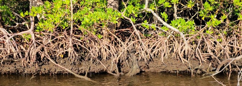
Figure 12. Prop roots of red mangrove tree.
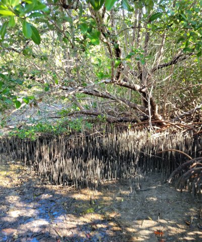
Figure 13. Pneumatophores of black mangrove tree.
These are dense forests occurring along relatively flat, low-wave energy, marine and estuarine shorelines. These species are dominated by mangroves, and often found in mixed stands or in differentiated, monospecific zones that reflect differences in tidal influence, salinity, and / or type of substrate. The following communities are mentioned separately due to their slight differences in different landscape positions. These often grade into one another but many times can not transition to one another.
Dominant resource concerns
-
Bank erosion from streams, shorelines, or water conveyance channels
-
Subsidence
-
Organic matter depletion
-
Concentration of salts or other chemicals
-
Ponding and flooding
-
Salts transported to surface water
-
Salts transported to ground water
-
Plant productivity and health
-
Plant structure and composition
-
Terrestrial habitat for wildlife and invertebrates
-
Aquatic habitat for fish and other organisms
Community 2.1
Overwash Mangrove Islands
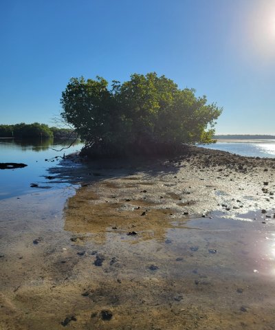
Figure 14. Overwash mangrove island at low tide building on unconciliated substrates.
Overwash Islands are small islands and narrow extensions of larger and masses (spits) that are “overwashed” on a daily basis during high tide and have high rates of organic export. These islands often develop as concentric rings of tall mangroves around smaller mangroves and a permanent, usually hypersaline, pools of water. All species of mangroves may be present, but red mangroves usually dominate. Maximum height of the mangroves is about 7 m (23 feet). These communities are particularly sensitive to the effects of ocean pollution.
Community 2.2
Fringe Mangrove Forest
Fringe mangrove forests are found along protected shorelines, on narrow berms along the coastline or in wide expanses along gently sloping beaches, along some canals, rivers, and lagoons. If a berm is present, the mangroves may be isolated from freshwater runoff and then have to depend completely on rainfall, the sea, and groundwater for their nutrient supply. These forests are best defined along shorelines whose elevations are higher than mean high tide. Maximum height of the mangroves is about 10 m (32 feet).
Community 2.3
Riverine Mangrove Forest
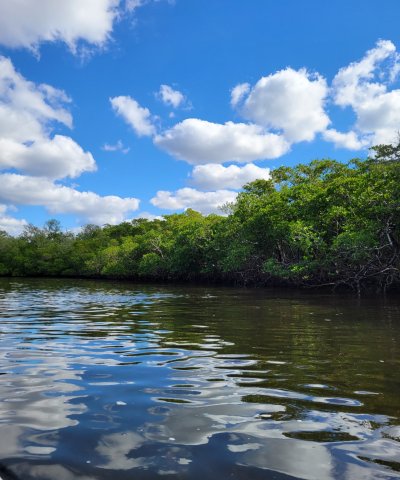
Figure 15. Mangroves growing on the border of a tidally influenced river.
Tall, productive riverine mangrove forests are found along the edges of coastal rivers and creeks, often several miles inland from the coast. These wetlands may be dry for a considerable time, although the water table is generally just below the surface. They are affected by freshwater runoff from adjacent uplands and from water, sediments, and nutrients delivered by the adjacent river. They can be significantly affected by upstream activity or stream alteration. The combination of adequate fresh water and high inputs of nutrients from both upland and estuarine sources cause these systems to be generally very productive, supporting large (16- 26 m) mangrove trees. Salinity in this community is usually lower than the other mangrove communities. The flushing of freshwater during wet seasons causes salts to be leached from the sediments.
Community 2.4
Basin Mangrove Forest
Basin mangrove forests occur in inland depressions, or basins, often behind fringe mangrove forests and in drainage depressions where water is stagnant or slowly flowing. These forests are often isolated from all but the highest tides and yet remain flooded for long periods once tide water does flood them. These forests are often dominated by black mangroves and white mangroves and the ground surface is often covered by pneumatophores from these trees. Trees may reach 15 m (49 feet) in height.
Community 2.5
Hammock Mangrove Forest
These forests occur as isolated, slightly raised tree islands in the coastal fringe of the Florida Everglades and have characteristics of both basin and scrub mangroves. They are slightly raised as a result of the buildup of peat in what was once a slight depression in the landscape. The peat has accumulated from many years of mangrove productivity, actually raising the surface from 5 to 10 cm above the surrounding landscape. All species of mangroves may be present, trees rarely exceed 5 m (16 feet) in height.
Community 2.6
Scrub / Dwarf Mangrove Forest
Scrub or dwarf mangrove forests are dominated by scattered, small (often less than 2 m tall) mangrove trees growing in an environment that is probably nutrient poor. These nutrient poor environments can be on a sandy soil or limestone marl. Hypersaline conditions and cold at the norther extremes of the mangrove’s ranges can produce “scrub”, or stressed mangrove trees, in riverine, fringe, or basin mangrove forests. Some of these forests are inundated by seawater only during spring tides or storm surges and are often flooded by freshwater runoff in the rainy season. These are an intermix of small red mangrove trees with marsh vegetation such as sawgrass (Cladium jamaicense) and rush (Juncus roemarianus).
Community 2.7
Buttonwood Forest
Button mangrove forests are dominated by button mangrove and often exist in the upper tidal areas, especially where mangrove swamps transition to rockland hammock. They can be open prairie like communities with button mangrove scattered in the overstory and an understory dominated by saltwater tolerant perennials.
State 3
Invasive Non-Native Community
This state consists of Florida Department of Agriculture and Consumer Services (FDACS) Non-Native Category 1 Species list . More information on these species list can be found:
https://www.fdacs.gov/content/download/63140/file/Florida%E2%80%99s_Pest_Plants.pdf
or by contacting the UF / IFAS Center for Aquatic and Invasive Plants (http://plants.ifas.ufl.edu/),
the UF / IFAS Assessment of Non-native Plants in Florida's Natural Areas (https://assessment.ifas.ufl.edu/),
or the FWC Invasive Plant Management Section (http://myfwc.com/wildlifehabitats/invasive-plants/).
This community will not represent every possibility of invasive species but rather the most common in these areas.
Characteristics and indicators. Non-native species include species that exist outside of Florida's native range and introduced to the state by people, weather, or any other means.
Resilience management. This state can be found as a part of any other state and can completely destroy the native habitat if not properly managed. Restoration to natural communities after exotic invasion include practices such as mechanical, biological, and chemical removal.
Dominant resource concerns
-
Subsidence
-
Concentration of salts or other chemicals
-
Nutrients transported to surface water
-
Plant productivity and health
-
Plant structure and composition
State 4
Human Altered and Human Transported Areas
These areas include soils that were intentionally and substantially modified by humans for an intended purpose, commonly for terraced agriculture, building support, mining, transportation, and commerce. The alteration is of sufficient magnitude to result in the introduction of a new parent material (human-transported material) or a profound change in the previously existing parent material (human-altered material). They do not include soils modified through standard agricultural practices or formed soils with unintended wind and water erosion. When a soil is on or above an anthropogenic landform or microfeature, it can be definitely be associated with human activity and is assigned to a unique taxa, usually found as an "Urban land complex" within that communities' natural soil properties (e.g., Keylargo muck, tidal-Urban land complex, 0-1% slopes).
Characteristics and indicators. Evidence of these areas include soils with manufactured items (e.g. artifacts) present in the profile, human altered-materials (e.g., deeply excavated or deeply plowed soil) or human-transported material (e.g., fill), and position on or above anthropogenic landforms (e.g., flood-control levees) and microfeatures (e.g., drainage ditches). Detailed criteria regarding the identification of anthropogenic (artificial) landforms, human-altered materials, and human-transported material are in the "Keys to Soil Taxonomy" (Soil Survey Staff, 2014).
Dominant resource concerns
-
Compaction
-
Ponding and flooding
-
Seasonal high water table
-
Emissions of greenhouse gases (GHGs)
-
Objectionable odors
-
Plant productivity and health
-
Plant structure and composition
Community 4.1
Reclaimed Area
Reclaimed areas are areas that have been modified through anthropogenic means that are restored to a natural or second-hand natural community. Areas that can be reclaimed are any intensity urban areas, and may be required to be reclaimed after urban use (e.g., constructed shorelines that have been reclaimed to native habitat). These practices include the identification, removal, and stockpiling soil materials before altering the land, and revegetation and replacement of soil materials after altering the land. This also applies to nearby urban areas that have been adversely affected by the anthropogenic activities.
Community 4.2
Urban
This urban community consists of development for human use. Urban areas include a variety of land uses, e.g., inner city or urban core, industrial and residential areas, cemeteries, parks, and other open spaces; the overall function which may benefit the quality of human life. These often form an urban soil mosaic, where the natural landscape has been fragmented into parcels with distinctive disturbance and management regimes and, as a result, distinctive characteristic soil properties.
Within this community there are three different levels of urbanization, based off population dynamics, residential density, and intensity of development. These are labeled as low-intensity, medium-intensity, and high-intensity urban areas, which can eventually be split apart into its own separate state. Low-intensity urban areas may consist of single dwelling homes with little impact on the surrounding community which still somewhat represents the natural community (e.g., represents natural landscape, hydrology, and vegetation) , other examples of this are urban parks, cemeteries, or campgrounds with little urban development. Medium-intensity urban areas consist of larger urban dwellings with some natural features, but have been modified to meet urban needs (e.g., towns). High-intensity urban areas are areas of heavily modified areas with complete alterations of the natural landscape, hydrology, and vegetation to support a very large population, which once constructed is permanently altered (e.g., metropolis areas/ active mines).
Pathway 4.1A
Community 4.1 to 4.2
This shift in communities is driven by clearing and developing the land for the desired community.
Pathway 4.2A
Community 4.2 to 4.1
This transition is driven by the revegetation, reestablished hydroperiods and replacement of displaced soil materials after altering the land.
State 5
Permanently Flooded Hydroperiod
This state describes the impact of increased hydroperiods from anthropogenic or natural causes that creates an altered hydrologic state resulting in permanent flooding. The impact of this causes destruction of the terrestrial community and may in time shift to a subaqueous community.
Characteristics and indicators. This state is characterized by permanent water levels in an area that was previously in an intertidal zone.
Resilience management. This is a final state and unlikely and improbable to go back to the original reference state.
Dominant resource concerns
Community 5.1
Ghost Forests (If wooded)
Ghost forests are the remains of a wooded vegetated community after changes in the long term hydroperiod (primarily sea level rise or artificial impoundment) permanently saturate the root system and becomes too saline for the species tolerance. They appear as standing dead wood representing where once the living vegetation stood. Evidence of previous shorelines may be found in subaqueous soil cores as root matter or a buried organic horizon.
Community 5.2
Unconsolidated Substrates
Figure 16. Unconsolidated Substrate found in intertidal zone which may have once supported vegetation.
These are expansive, relatively open areas of intertidal and supratidal zones which lack dense populations of sessile plant and animal species, Unconsolidated Substrates are unsolidified material and include marl, mud, mud/sand, sand or shell.
Unconsolidated Substrates are important in that they form the foundation for the development of other subaqueous and intertidal natural communities when conditions become appropriate. Unconsolidated Substrate communities are associated with and often grade into mangrove forests or salt marshes (herbaceous wetlands) in this ecosite. This is a highly fluctuating community and is altered by storm events, with numerous management plans that include beach reestablishment and coastal stabilization projects. Unconsolidated sediments can originate from organic sources, such as decaying plant tissues (e.g., mud) or from calcium carbonate depositions of plants or animals (e.g., coralgal, marl and shell substrates). Marl and coralgal substrates are primarily restricted to the southern portion of the state. These communities are typically seen as tidal or mud flats and have high contents of acid sulfates.
Resilience management. This is a highly fluctuating community and is altered by storm events, with numerous management plans that include coastal stabilization projects.
Community 5.3
Open Water
This is the final state and is when alteration of the natural hydroperiod has left an area permanently flooded. No terrestrial vegetation representative of the reference state will be present but may support rooted submerged aquatic vegetation (SAV) species if proper growth conditions are met.
Pathway 5.1A
Community 5.1 to 5.2
This transition is driven by acid sulfate dynamics which causes a shift from a ghost forest to an area of unconsolidated substrates. This often occurs after a disturbance event creates an open area within a mangrove forest, allowing for the waterlogged soils under the forest to become exposed to air long enough for the soil to oxidize, forming sulfuric acid (pH <4.5). This will significantly alter the composition of the soil matrix and result in a highly acidic environment in which vegetation is unable to grow.
Pathway 5.1B
Community 5.1 to 5.3
This is caused by anthropogenic or natural increases in hydroperiods causing the area to be permanently flooded.
Pathway 5.2A
Community 5.2 to 5.3
This is caused by anthropogenic or natural increases in hydroperiods causing the area to be permanently flooded.
Transition T1A
State 1 to 2
This mechanism is driven by land encroachment, in which mangrove communities are able to move landward as their growth conditions change (e.g., increase salinity, decreased freshwater, sea level rise, more intense tidal flooding). Mangroves are well adapted to various salinities and are able to rapidly colonize and area.
Constraints to recovery. Shifts to mangrove communities are usually seen with changes in sea level rise, and recovery back to salt marshes are typically unseen due to the success of mangroves in more hostile saline conditions.
Transition T1B
State 1 to 3
The invasion of non-native or exotic species can be driven by a multitude of different environmental factors such as changes in natural hydroperiods or in fire regimes. Typically once a change in one of the two factors mentioned above occurs, non-native or exotic invasive species become established and begin to compete with native species for habitat and nutrients.
Constraints to recovery. Recovery from non-native or exotic invasive species may be difficult due to many adaptations which allow them to survive and outcompete in intolerable conditions. Localized knowledge for each species must be known for best removal of it without harming the native environment, and often different treatments must be applied over one given area.
Context dependence. Growth of non-native and exotic invasive species can be rapid following a change in a natural stressor such as fire frequency or natural hydroperiods which might have once kept the invasive species at bay.
Transition T1C
State 1 to 4
This transition is driven by the alteration and/ or transportation of materials via anthropogenic means.
Transition T1D
State 1 to 5
This is driven by increased hydroperiods, both anthropogenic and natural, which causes long-term flooding and permanently altering the state.
Transition T2A
State 2 to 3
The invasion of non-native or exotic species can be driven by a multitude of different environmental factors such as changes in natural hydroperiods or in fire regimes. Typically once a change in one of the two factors mentioned above occurs, non-native or exotic invasive species become established and begin to compete with native species for habitat and nutrients.
Constraints to recovery. Recovery from non-native or exotic invasive species may be difficult due to many adaptations which allow them to survive and outcompete in intolerable conditions. Localized knowledge for each species must be known for best removal of it without harming the native environment, and often different treatments must be applied over one given area.
Context dependence. Growth of non-native and exotic invasive species can be rapid following a change in a natural stressor such as fire frequency or natural hydroperiods which might have once kept the invasive species at bay.
Transition T2B
State 2 to 4
This transition is driven by the alteration and/ or transportation of materials via anthropogenic means.
Transition T2C
State 2 to 5
This is driven by increased hydroperiods, both anthropogenic and natural, which causes long-term flooding and permanently altering the state.
Restoration pathway R3A
State 3 to 1
Mechanical, biological, and chemical removal strategies include removing the non-native and exotic invasive species through various mechanisms. Localized knowledge for individual non-native or exotic invasive species is needed for specific management. Sometimes introduction of fire regimes may prevent or stop the growth of non-native or exotic invasive species, but many species are fire tolerant. Mechanical removal might include roller chopping, harvesting, or cutting and removal of invasive species. Chemical removal might include aerial dispersal from planes, or basal bark injection treatments.
Context dependence. Mechanical, biological, and chemical removal of non-native and exotic invasive species is a time dependent process, with both removal types taking long times to be considered effective.
Restoration pathway R3B
State 3 to 2
Mechanical, biological, and chemical removal strategies include removing the non-native and exotic invasive species through various mechanisms. Localized knowledge for individual non-native or exotic invasive species is needed for specific management. Sometimes introduction of fire regimes may prevent or stop the growth of non-native or exotic invasive species, but many species are fire tolerant. Mechanical removal might include roller chopping, harvesting, or cutting and removal of invasive species. Chemical removal might include aerial dispersal from planes, or basal bark injection treatments.
Context dependence. Mechanical, biological, and chemical removal of non-native and exotic invasive species is a time dependent process, with both removal types taking long times to be considered effective.
Transition T3A
State 3 to 4
This transition is driven by the alteration and/ or transportation of materials via anthropogenic means.
Transition T3B
State 3 to 5
This is driven by increased hydroperiods, both anthropogenic and natural, which causes long-term flooding and permanently altering the state.
Transition T4A
State 4 to 5
This is driven by increased hydroperiods, both anthropogenic and natural, which causes long-term flooding and permanently altering the state.