Subtropical Freshwater Non-Forested Glades Marshes and Slough Wetlands of Everglades
Scenario model
Current ecosystem state
Select a state
Management practices/drivers
Select a transition or restoration pathway
-
Transition T1A
Organic Matter Loss
More details -
Transition T1B
Water Drainage Control Infrastructure / Desired Forage Establishment
More details -
Transition T1C
Water Drainage Control Infrastructure / Commodity Crop Establishment
More details -
Restoration pathway R2A
Reestablished Natural Hydroperiod / Organic Matter Accumulation / Sawgrass Development
More details -
Transition T2A
Water Drainage Control Infrastructure / Desired Forage Establishment
More details -
Transition T2B
Water Drainage Control Infrastructure / Commodity Crop Establishment
More details -
Transition T3A
Commodity Crop Establishment
More details -
Restoration pathway R3A
Natural Hydroperiod Restoration / Landscape Modification / Native Species Planting
More details -
Transition T3B
Human Alteration Human Transportation of Materials
More details -
Transition T4A
Desired Forage Establishment
More details -
Restoration pathway R4A
Natural Hydroperiod Restoration / Landscape Modification / Native Species Planting
More details -
Transition T4B
Human Alteration Human Transportation of Materials
More details -
Restoration pathway R6A
Natural Hydroperiod Restoration / Landscape Modification / Native Species Planting
More details -
No transition or restoration pathway between the selected states has been described
Target ecosystem state
Select a state
Description
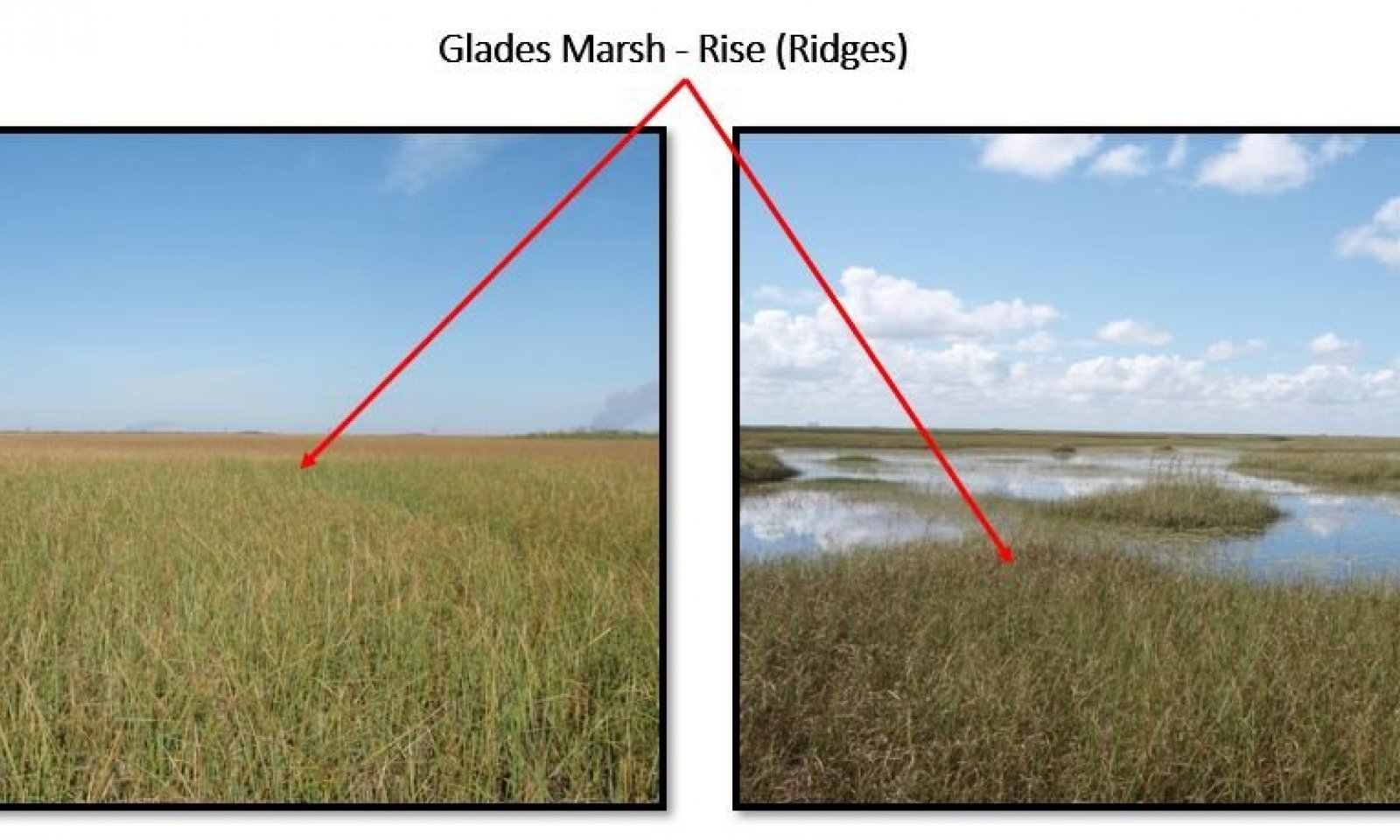
Glades Marsh is an open expanse of grass in areas where the soil is saturated or covered with surface water 6 to 9 months or more during the year. The natural (native) vegetation of this community is mainly dominated by Jamaica sawgrass (Cladium jamaisence).
Characteristics and indicators
Under natural conditions the sawgrass can be 6 to 10 feet tall and of such density that few other plants can survive. The soil is saturated or covered with surface water 6 to 9 months or more during the year.
Resilience management
Soils need to be saturated for 6 to 9 months or more during the year. Controlled fire during the wet season is needed. Desirable water labels should be around 12 to 16 inches (30 centimeters to 41 centimeters).
Description
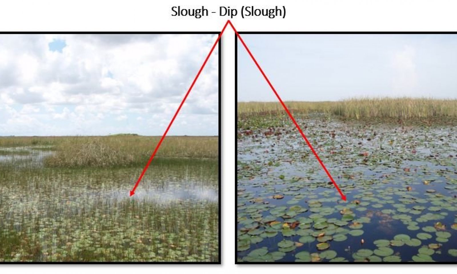
Sloughs are the deepest drainageways within swamps and marsh systems. They are broad channels inundated with slow moving or nearly stagnant water, except during extreme droughts. The vegetation structure is variable with some sloughs dominated by floating aquatics, others by large emergent herbs, and still others by a low or sparse canopy. The water in these dips\sloughs is slow moving, and sloughs may dry completely during droughts. Under natural conditions these areas exhibit longer hydroperiods (6 to 11 months). In south Florida, submerged plants and algae (including cyanobacteria, known as periphyton, found in more alkaline waters) can form mats in sloughs that contribute food and oxygen.
Characteristics and indicators
Under natural conditions these areas exhibit longer hydroperiods (6 to 11 months), the vegetation is dominated by floating aquatics, others by large emergent herbs, and still others by a low or sparse canopy. During extended periods of droughts these areas become a refuge for wildlife.
Resilience management
Maintain the natural drainage and surface water flow that sustained a adequate balance of ponding levels, duration and soil saturation. These areas are sensitive to fire and don't benefit from prescribe fire.
Description
The land use on these areas are known as improve pastures areas and are mainly dedicated to the cattle industry. The major impact of the drained areas for cattle is soil subsidence due to the oxidation of the Sapric Soils materials. However, when these areas are well maintained these pastures contribute to the native plant and animal habitat as well as aquifer recharge. Birds and other wildlife thrive on lands used for cattle production. These areas require water management to control seasonal flooding of the fields; presence of drainages ditches and canals are abundant. These canals act as a water source for the cattle and as wildlife refuge. These pastures are open and have few to no trees, with existing trees (primarily oak and palms) serving as areas for shade.
Characteristics and indicators
Presence of drainages ditches and canals. Absence of Jamaica sawgrass (Cladium jamaicense). Land is leveled with none to few areas that can sustain herbaceous plants like Gulf Coast spikerush (Eleocharis cellulosa), American water lily (Nymphaea odorata), bladderworts (Utricularia spp.). Soil surface is not exposed and will be mainly covered by forage plants like Limpograss (Hemarthria altissima - introduced), St. Augustinegrass (Stenotaphrum secunda-tum - introduced), Maidencane (Panicum hemitomon - native), Blue Maidencane (Amphicarpum muhlenber-gianum - native).
Resilience management
To keep the pasture at a desirable stage these areas require water management to control seasonal flooding and ponding. A proper grazing plan is needed to prevent overgrazing and loss of the soil resource.
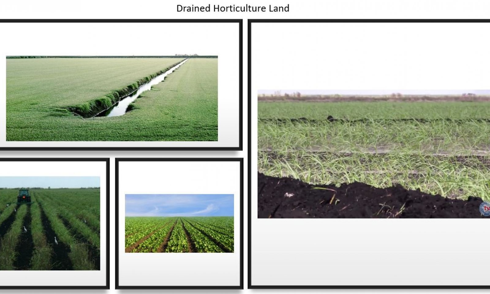
Description
These areas serve to provide cane sugar, grains and vegetables. These areas provide primarily winter vegetables including sweet corn, radishes, green beans, lettuce and other leafy greens, as well as rice and sugarcane. The areas have been drained and laser leveled to accommodate to the horticulture crops.
Characteristics and indicators
Presence of drainages ditches, water control structures, and canals. Absence of Jamaica sawgrass (Cladium jamaicense), Gulf Coast spikerush (Eleocharis cellulosa), American water lily (Nymphaea odorata), bladderworts (Utricularia spp.). Winter vegetables including sweet corn, radishes, green beans, lettuce and other leafy greens, as well as rice and sugarcane are commonly seen through the year. Parcels under rest or under crop rotation process will be artificially inundated to reduce soil subsidence. During the crop rotation or resting period if the area is not well maintain invasive plants like Cogon grass (Imperata cylindrica), Amaranthus (Amaranthus albus), Elephant grass ( Pennisetum purpureum), Higuereta (Ricinus communis), etc., can grow. Along the side of the canals banks if is not well maintained Brazilian peppertree (Schinus teredinthifolia) and Melaleuca (Melaleuca quinquenervia) can grow. Evidence of organic soil subsidence can be seen.
Resilience management
The hydrology of these areas are very resilient, if proper water control is not managed correctly these areas will remain inundated during the raining season causing the loss of the crops. If not controlled Typha (Typha sp.), Brazilian peppertree (Schinus teredinthifolia), and Melaleuca (Melaleuca quinquenervia) will grow at a fast rate suppressing the native vegetation.
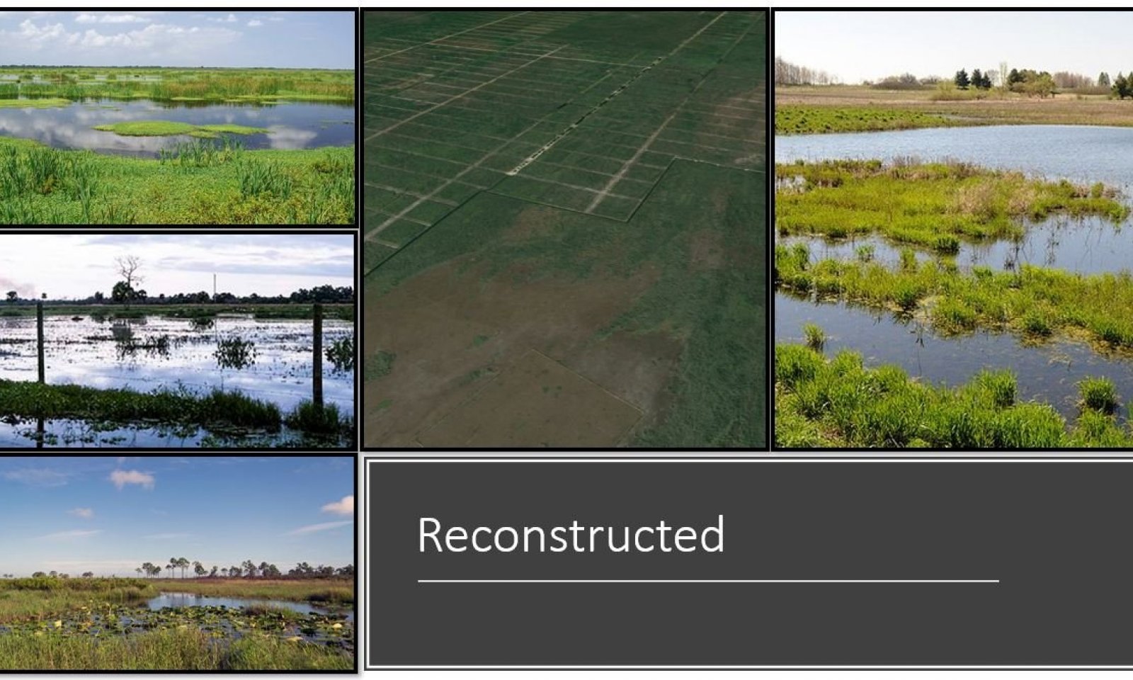
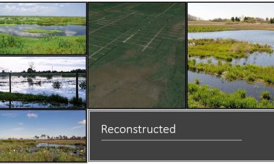
Description
This state can be defined as the manipulation of a former or degraded wetland's physical, chemical, or biological characteristics to return its natural functions. The State 3: "Drained Pastureland" and State 4: "Drained Horticulture Land" can transition to this reconstructed state if the correct practices and management are put in place. Some general guiding principles are; Restore the natural function, restore natural structure, restore ecological integrity, restore native species avoiding non-native species, etc.
Characteristics and indicators
A reconstructed state will be easy to recognize through the landscape because it will create a boundary between two different habitat types. Wildlife diversity is greater along edges due to the different habitat types. After restoring the water flow from a drained condition to a more natural water flow and right ponding duration, the succession or progression of plant communities over time a freshwater marsh may gradually fill in with dense emergent and shrubs. Some invasive species (Melaleuca - Melaleuca quinquenervia, Brazilian pepper - Schinus terebinthifolia, and Cattail – Typha .spp) will grow. Areas with long to very long hydroperiods (6 to 11 months) will promote submerge and emergent vegetation, increasing the possibility of a slough vegetative community reestablishment. Glades marshes will require shorter hydroperiods but longer duration (6 to 9 months) and in many cases replanting is needed to speed up the reestablishment of the Jamaica sawgrass (Cladium jamaisence), suppress other type of grasses and aquatic emergent vegetation.
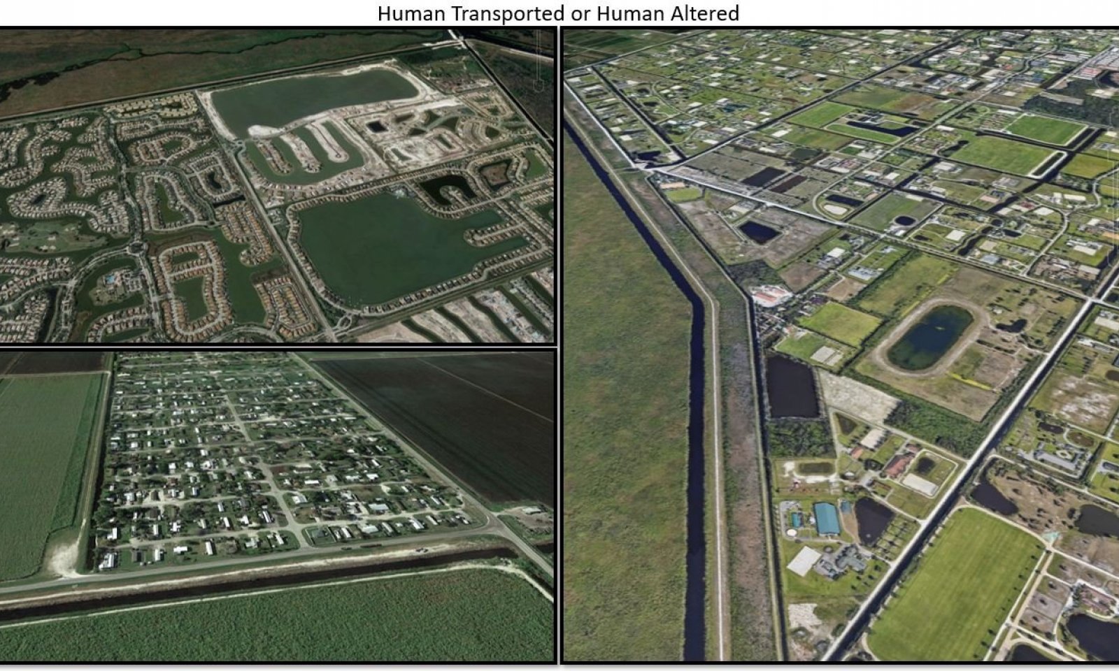
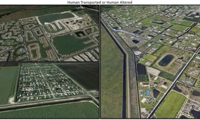
Description
Human Transported and Human Altered (HTHA) refer to all the vegetative communities that exist on soils that has been modified by anthropogenic activities. These HTHA areas are widespread across the MLRA 156A and are concentrated near where people live and work. These areas exist on soils that has been altered by humans. The two types of soils that fits this concept; Human-altered soils formed in human-altered materials from the soil surface to 50 cm (20 inches) (or to bedrock if shallower) or more, and human-transported soils formed in human-transported materials from the soil surface to 50 cm (20 inches) (or to bedrock if shallower) or more. The HTHA soils mainly occur in urban areas, transportation corridors, mined lands, landfills, filled shallow water, and agricultural areas on anthropogenic landforms. Dominant vegetation in areas well maintain will be ornamentals herbaceous and trees. Areas that aren’t well maintain will be overgrow by invasive grasses and trees. Reservoirs and anthropogenic ponded areas may support slough vegetation and can provide some wetland benefits. HTHA are extensive, and their extent is growing.
Characteristics and indicators
The existing vegetation will be located between sidewalks and roads, in home sites development, public gardens, botanical gardens, retention ponds, water reservoirs and parks. Areas with vegetation represent a percent of pervious surface that can range from 10 to 70 percent throughout the areas that people live and work. Landscapes are typically flat, with man made rises and knolls to elevate the surface above flood zones for home or urban development. Lower areas / depressions are often utilized for surface water control during the wet season.
Resilience management
Some open areas that were once altered and prepared for urban development that have been purchased by conservation programs exist, these areas are potential sites for restoration.
Mechanism
The Glades Marshes can transition to a Slough due to wildfires if they occur when water levels are too low causing an entire burn of the Jamaica sawgrass (Cladium jamaisence). If the entire plant burns the surface sapric material (muck\ mucky peat) burns as well creating a lower depression or dip. When the water levels get back to normal, floating aquatics and others by large emergent herbs rapidly colonize and suppress the stressed Jamaica sawgrass. If hydroperiods are not properly balanced after a wildfire takes place the chance for Glades Marsh vegetation to recover are very low. Anthropogenic activities like hunting, airboat, and swam buggy activities contribute to the Jamaica sawgrass displacement and the Sloughs establishment by causing soil surface erosion. In dry seasons alligators may displace the vegetation creating a slough by creating gator holes to reach available water.
Constraints to recovery
Proper water levels control. Proper water flow. Removal of any anthropogenic activities. Dominant species replanting / recolonization. Control of wildlife. Surface erosion control.
Context dependence
Loss of sapric material due to fire, wildlife, and anthropogenic activities'. Hydroperiods elongation due to a change of the geomorphology of the area affected.
Mechanism
The Glades Marshes state can transition to Drained Pastureland state by establishing water drainage control infrastructure. These practices include; constructing canals to drain the soils up to 20 inches (50 cm) from the surface, construction of water control gates to move the water from one parcel to another, removal of all native existing vegetation, land leveling, introduction of desirable forages to establish a pasture, and construction of roads.
Mechanism
The Glades Marshes state can transition to Drained Horticulture Land state by establishing water drainage control infrastructure. These practices include; constructing canals to drain the soils up to 20 inches (50 cm) from the surface, construction of water control gates to move the water from one parcel to another, removal of all native existing vegetation, land leveling, introduction of desirable commodity crops and construction of roads.
Mechanism
To restore from a Slough to Glades Marshes, an effective water level and ponding period (approximately 6 to 9 months) needs to be established. Normally with a natural water flow reestablishment these conditions can be achieved. A reestablished hydroperiod will allow for the accumulation of new organic mater in the soil profile, raising the soil surface and creating suitable habitat for sawgrass growth. Wildlife (Alligator) control is needed to prevent eroding activities for nesting and gator habitat development (gator holes are commonly described as sloughs). Airboat activity needs to be suspended or monitored because the erosion to the soil surface and because the airboat friction can kill the grass. Reseeding and planting may be needed to increase the grass population, coverage, and grass thickness to suppress any other plants. An aggressive invasive plants control is needed to prevent or reduce the establishment of Typha sp. and Melaleuca (Melaleuca quinquenervia) plants.
Context dependence
Without the correct water flow, correct water levels, and ponding period (approximately 6 to 9 months), the chances of the Glades Marches to recover and thrive are low. The lack of wildlife, airboat, and invasive plants can encourage new Sawgrass growth. Because of the slow reestablishment of the sawgrass, if a reseeding and planting step is not added to the restoration effort the chance of other herbaceous vegetation take over are high.
Mechanism
The Slough state can transition to Drained Pastureland state by establishing water drainage control infrastructure. These practices include; constructing canals to drain the soils up to 20 inches (50 cm) from the surface, construction of water control gates to move the water from one parcel to another, removal of all native existing vegetation, land leveling, introduction of desirable forages to establish a pasture, and construction of roads.
Mechanism
The Slough state can transition to Drained Horticulture Land state by establishing water drainage control infrastructure. These practices include; constructing canals to drain the soils up to 20 inches (50 cm) from the surface, construction of water control gates to move the water from one parcel to another, removal of all native existing vegetation, land leveling, introduction of desirable commodity crops and construction of roads.
Mechanism
The Drained Pastureland can transition to Drained Horticulture Land state by the removal of all established forages and introduction of desirable commodity crops. Establishment of water drainage control infrastructure is needed if not already present. These practices include; constructing canals to drain the soils up to 20 inches (50 cm) from the surface, construction of water control gates to move the water from one parcel to another, and construction of roads.
Constraints to recovery
To recover or reconstruct back to a Drained Pastureland state from a Drained Horticulture Land state all commodity crops needs to be removed and all desirable forages will need to be reintroduced. Land leveling and keeping drainage control infrastructure is needed. An aggressive invasive species control program will need to be put in place to prevent the establishment of Typha (Typha sp.), Brazilian peppertree (Schinus teredinthifolia), and Melaleuca (Melaleuca quinquenervia).
Mechanism
To reconstruct from a Drained Pastureland to a Reconstructed Slough and Glades Marsh state, the natural water flow and hydroperiod of the area needs to be restored. All water control and drainages infrastructure need to be removed. Landscape modification will be needed to mimic or simulate the original geomorphic positions to establish the correct hydroperiod durations of the Slough and Glades Marsh States. Replanting native vegetation may be needed.
Context dependence
Adequate water levels, mimic the correct hydroperiods duration, and establish a consistent invasive species control to reduce or eliminate the presence of grasses (forages and other invasive plants like Brazilian peppertree (Schinus teredinthifolia), Typha sp. and Melaleuca (Melaleuca quinquenervia). Establish reseeding and replanting procedures.
Mechanism
To transition from a Drained Pastureland to a Human Transported or Human Altered state, a more aggressive water control and drainages infrastructure will be put in place. Land leveling will occur and will change the entire natural landscape. Most of the original vegetation will be removed. Transportation and removal of soils materials will occur to meet urban development needs. These practices will affect the natural physical, chemical and biological conditions of the soils affected. The percent of impervious surfaces will range from 0 % to 100 %. Dominant vegetation in areas that are well maintained will be ornamentals evergreen shrubs, ornamental herbaceous species, and trees. Areas that aren’t well maintained will be overgrow by native vegetation and invasive species. Reservoirs and anthropogenic ponded areas may support slough vegetation and can provide some wetland benefits.
Constraints to recovery
To recover or reconstruct to Drainage Horticulture Land, all desirable forages will need to be reintroduced. The land needs to be cleaned and free of any non-natural solid waste. All water control and drainages infrastructure will remain. An invasive species control program will need to be put in place to prevent the establishment of undesirable grasses, and other plants.
Mechanism
To reconstruct from Drained Horticulture Land to Drained Pastureland, all commodity crops needs to be removed and the reintroduction of the desirable forages are needed. Water control and drainages infrastructure will remain. Minor land leveling and manipulation may be needed to promote the forage growth. An aggressive invasive species control program will need to be put in place to prevent the establishment of Typha (Typha sp.), Brazilian peppertree (Schinus teredinthifolia), and Melaleuca (Melaleuca quinquenervia).
Context dependence
Keep adequate water control and drainages infrastructure. Establish species control program to prevent the establishment of undesirable grasses (forages), and other plants.
Restoration pathway R4A
Mechanism
To reconstruct from a Drained Horticulture Land to a Reconstructed Slough and Glades Marsh state, the natural water flow and hydroperiod of the area needs to be restored. All water control and drainages infrastructure need to be removed. Commodity crops will need to be removed, reseeding and replanting of desirable native species will be needed. Landscape modification will be needed to mimic or simulate the original geomorphic positions to establish the correct hydroperiod durations of the Slough and Glades Marsh States. Replanting native vegetation may be needed.
Context dependence
Adequate water levels, mimic the correct hydroperiods duration, and establish a consistent invasive species control to reduce or eliminate the presence of grasses (forages and other invasive plants like Brazilian peppertree (Schinus teredinthifolia), Typha sp. and Melaleuca (Melaleuca quinquenervia). Establish reseeding and replanting procedures.
Mechanism
To transition from a Drained Horticulture Land to a Human Transported or Human Altered state, a more aggressive water control and drainages infrastructure will be put in place. Land leveling will occur and will change the entire natural landscape. Most of the original vegetation will be removed. Transportation and removal of soils materials will occur to meet urban development needs. These practices will affect the natural physical, chemical and biological conditions of the soils affected. The percent of impervious surfaces will range from 0 % to 100 %. Dominant vegetation in areas that are well maintained will be ornamentals evergreen shrubs, ornamental herbaceous species, and trees. Areas that aren’t well maintained will be overgrow by native vegetation and invasive species. Reservoirs and anthropogenic ponded areas may support slough vegetation and can provide some wetland benefits.
Constraints to recovery
To recover or reconstruct to a Drainage Horticulture Land, all desirable forages will need to be reintroduced. The land needs to be cleaned and free of any non-natural solid waste. All water control and drainages infrastructure will remain. An invasive species control program will need to be put in place to prevent the establishment of undesirable plants. Re introduce all the desirable commodity crops.
Context dependence
Keep adequate water control and drainages infrastructure. The land needs to be cleaned and free of any non-natural solid waste. All water control and drainages infrastructure will remain. Establish species control program to prevent the establishment of undesirable plants.
Restoration pathway R6A
Mechanism
To reconstruct from a Human Transported or Human Altered state to a Reconstructed Slough and Glades Marsh state, the natural water flow and hydroperiod of the area needs to be restored. All water control and drainages infrastructure need to be removed. Urban structures will need to be removed, reseeding and replanting of desirable native species will be needed. Landscape modification will be needed to mimic or simulate the original geomorphic positions to establish the correct hydroperiod durations of the Slough and Glades Marsh States. Replanting native vegetation may be needed.
Context dependence
Adequate water levels, mimic the correct hydroperiods duration, and establish a consistent invasive species control to reduce or eliminate the presence of grasses (forages and other invasive plants like Brazilian peppertree (Schinus teredinthifolia), Typha sp. and Melaleuca (Melaleuca quinquenervia). Establish reseeding and replanting procedures. The land needs to be cleaned and free of any non-natural solid waste.
Model keys
Briefcase
Add ecological sites and Major Land Resource Areas to your briefcase by clicking on the briefcase (![]() ) icon wherever it occurs. Drag and drop items to reorder. Cookies are used to store briefcase items between browsing sessions. Because of this, the number of items that can be added to your briefcase is limited, and briefcase items added on one device and browser cannot be accessed from another device or browser. Users who do not wish to place cookies on their devices should not use the briefcase tool. Briefcase cookies serve no other purpose than described here and are deleted whenever browsing history is cleared.
) icon wherever it occurs. Drag and drop items to reorder. Cookies are used to store briefcase items between browsing sessions. Because of this, the number of items that can be added to your briefcase is limited, and briefcase items added on one device and browser cannot be accessed from another device or browser. Users who do not wish to place cookies on their devices should not use the briefcase tool. Briefcase cookies serve no other purpose than described here and are deleted whenever browsing history is cleared.
Ecological sites
Major Land Resource Areas
The Ecosystem Dynamics Interpretive Tool is an information system framework developed by the USDA-ARS Jornada Experimental Range, USDA Natural Resources Conservation Service, and New Mexico State University.