Ecological dynamics
The information presented in this ecological site description (ESD) and state-and-transition model (STM) were developed using archaeological and historical information, published and unpublished scientific reports, professional experience, consultation with technical experts, and NRCS inventories and studies. The information presented represents a complex set of plant community dynamic and environmental variables. Not all scenarios or plants are represented and included. Key indicator plants, animals, and ecological processes are described to help guide land management decisions and actions.
The natural (native) vegetation of this community is mainly dominated by Jamaica sawgrass (Cladium jamaisence). Other grasses can become obvious when the sawgrass is repeatedly exposed to fire and / or the hydroperiod is shortened. Under natural conditions the sawgrass can be 6 to 10 feet tall and of such density that few other plants can survive. Other marsh plants invade the sawgrass where marginal conditions occur for sawgrass growth. These condition may include changes in hydroperiod, water flow, wildlife altered habitat (gator holes- see below), fire, and anthropogenic activities. Trees are not dominant, occuring in areas with lowered hydroperiods, often found on slightly higher rises or knolls (tree islands). In areas with relatively sparse vegetation, mats of algae called periphyton are commonly attached to plants in the water column. This periphyton is often considered calcareous due to the dominance of certain filamentous blue-green algae species.
There are two dominant vegetative communities groups interacting with the geomorphic positions of the area;
1. Glades Marsh - The dominant herbaceous plant that occurs in these areas are grasses such as Jamaica sawgrass (Cladium jamaicense). Other herbaceous plants that occur are giant bristlegrass (Setaria magna), gulf muhly (Muhlenbergia capillaris), broomsedges (Andropogon spp.), sugarcane plumegrass (Saccharum giganteum), plume grass (Erianthus spp.), maidencane (Panicum hemitomon), Tracy’s beaksedge (Rhynchospora tracyi), and Gulf Coast spikerush (Eleocharis cellulosa). Various other herbs are common, particularly shortbristle horned beaksedge (R. corniculata), slim spikerush (E. elongata), string lily (Crinum americanum), alligatorlily (Hymenocallis palmeri), creeping primrosewillow (Ludwigia repens), bulltongue arrowhead (Sagittaria lancifolia), pickerelweed (Pontederia cordata), and American cupscale (Sacciolepis striata). During periods of high water and in areas transitional to deeper conditions floating plants such as big floatingheart (Nymphoides aquatica), American water lily (Nymphaea odorata) and bladderworts (Utricularia spp.) may be common. Cattails (Typha spp.) are increasingly abundant in areas of the Everglades where water quality is degraded by agricultural run-off or where water is impounded by roads and canals. Drought conditions may allow other herbs to temporarily gain importance, such as southern amaranth (Amaranthus australis), dogfennel (Eupatorium capillifolium), camphorweeds (Pluchea spp.), thistles (Cirsium spp.), asters (Symphyotrichum spp.), knotweeds (Polygonum spp.), morning glory (Ipomoea sagittata), and white twinevine (Sarcostemma clausum) may be found climbing sawgrass blades. Periphyton is found in these areas and can form mats that contribute food and oxygen.
2. Slough - Dip / Depressions - The dominant herbaceous plants that occurs in these areas are Gulf Coast spikerush (Eleocharis cellulosa), American water lily (Nymphaea odorata), bladderworts (Utricularia spp.), big floatingheart (Nymphoides aquatica) and yellow pondlily (Nuphar advena). Other herbaceous plants that occur are frog’s bit (Limnobium spongia), duckweeds (Lemna spp.), alligatorflag (Thalia geniculata), bandana-of-the-Everglades (Canna flaccida), pickerelweed (Pontederia cordata), bulltongue arrowhead (Sagittaria lancifolia), giant cutgrass (Zizaniopsis miliacea), and lizard’s tail (Saururus cernuus) are common. Periphyton is found in these areas and can form mats that contribute food and oxygen.
Natural Processes of the sites: The Glades Marsh occurs with near constant flooding of glades marshes, combined with the warm subtropical climate, contributes to a lush growth of sawgrass on slightly higher “ridges” and waterlily (Nymphaea sp.) in the lowest dips\sloughs. The long hydroperiod (3 to 9 months) creates an anaerobic soil environment in which the breakdown of sapric organic material is impeded, and sediments from dead vegetation continually accumulates, forming the characteristic sapric organic material. Although most of the glades marsh is located on accumulated sapric organic soil materials, sometimes several meters thick, the substrate may vary due to soil oxidation, fire, or other factors. Fire is a natural component of this landscape. Dominant herbaceous plants in the Everglades, particularly sawgrass, maidencane, and bulltongue arrowhead, grow vigorously following fire under normal conditions, i.e. when water levels are still near the soil surface and shorter hydroperiods (3 to 6 months). The porous limestone surface underlying the basin allows for some interaction between surface water and ground water within the limestone, leading to a slightly basic surface water environment with high calcium levels. These conditions lower phosphorus bioavailability and tend to perpetuate sawgrass dominance.
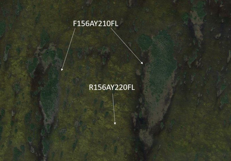
The water in these dips\sloughs is slow moving, and sloughs may dry completely during droughts. In South Florida, some of these areas have formed from the burning of underlying sapric organic soil materials layers in strand swamps and glades marsh during droughts. These sloughs\dips also known as depressions then fill with water when the site is once again flooded causing longer hydroperiods (6 to 11 months) allowing water emergent vegetation communities to be established. As such, these can be shifting communities, with old sloughs eventually filling in with peat while new ones are created by peat fires which cannot be mapped and are part of the system. Coastal plain willow is a common colonizer when fires have consumed soils in the Everglades Ecoregion. Alligators further create heterogeneity in sloughs by wallowing and digging in the peat substrate, excavating “gator holes” which will elongate the hydroperiods (6 to 11 months) and resulting in the creation of refuge for wildlife during droughts. Under drought conditions, wildfires may burn down the peat layer, destroying sawgrass roots and converting these areas to lower elevation creating longer hydroperiods (6 to 11 months) allowing emergent communities or to deeper water (sloughs\dips). Topographic variation may result not only from severe fires, but also from highs and lows in the underlying limestone bedrock, or from the formation of sapric organic materials tree islands, or batteries . These batteries are most common in the northeastern Everglades where solid masses of peat become dislodged from the floor of the marsh and drift to a new location, eventually reattaching to the bottom. The topographic high created by the sapric organic materials formation may become colonized with woody vegetation, especially swamp bay (Persea palustris), and can ultimately become a tree island (F156AY210FL), while the hole left behind will become a much deeper allowing water emergent communities vegetation (slough\dips).
State 1
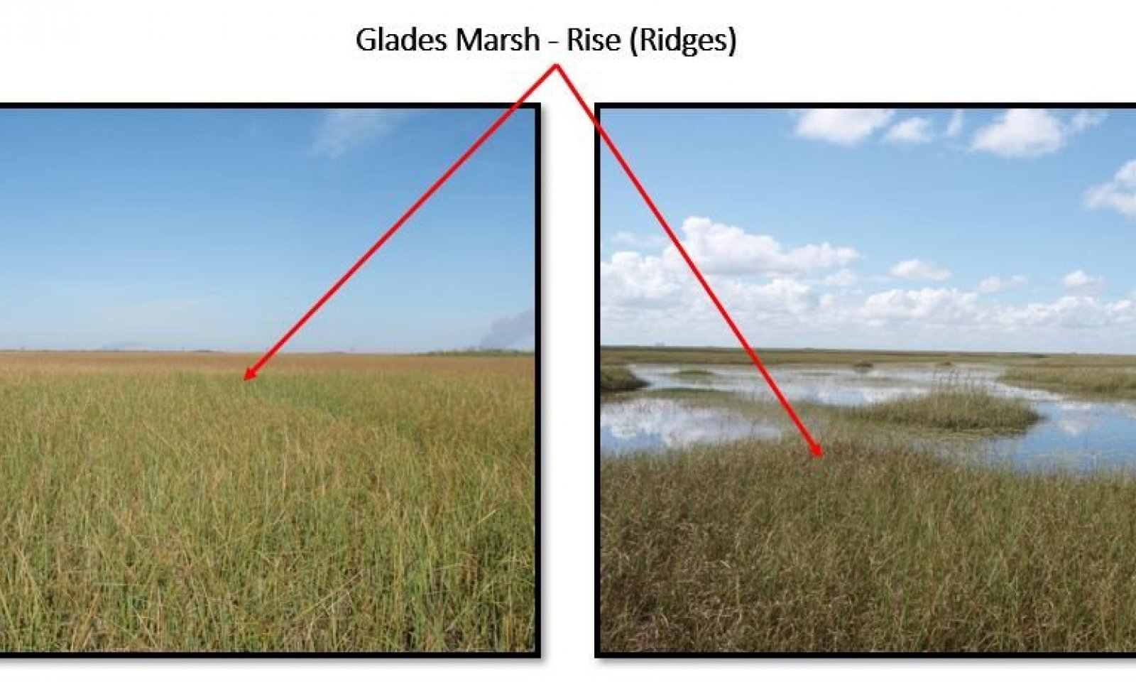
Glades Marsh

Figure 17. Representative glades marsh dominated by sawgrass.
Glades Marsh is an open expanse of grass in areas where the soil is saturated or covered with surface water 6 to 9 months or more during the year. The natural (native) vegetation of this community is mainly dominated by Jamaica sawgrass (Cladium jamaisence).
Characteristics and indicators. Under natural conditions the sawgrass can be 6 to 10 feet tall and of such density that few other plants can survive. The soil is saturated or covered with surface water 6 to 9 months or more during the year.
Resilience management. Soils need to be saturated for 6 to 9 months or more during the year. Controlled fire during the wet season is needed. Desirable water labels should be around 12 to 16 inches (30 centimeters to 41 centimeters).
Dominant plant species
-
Jamaica swamp sawgrass (Cladium mariscus ssp. jamaicense), grass
-
sugarcane plumegrass (Saccharum giganteum), other herbaceous
-
Gulf Coast spikerush (Eleocharis cellulosa), other herbaceous
-
seven sisters (Crinum americanum), other herbaceous
-
alligatorlily (Hymenocallis palmeri), other herbaceous
-
bulltongue arrowhead (Sagittaria lancifolia), other herbaceous
-
tropical pickerelweed (Pontederia rotundifolia), other herbaceous
-
American white waterlily (Nymphaea odorata), other herbaceous
-
bladderwort (Utricularia), other herbaceous
-
southern cattail (Typha domingensis), other herbaceous
-
saltmarsh morning-glory (Ipomoea sagittata), other herbaceous
-
maidencane (Panicum hemitomon), other herbaceous
Dominant resource concerns
State 2
Slough
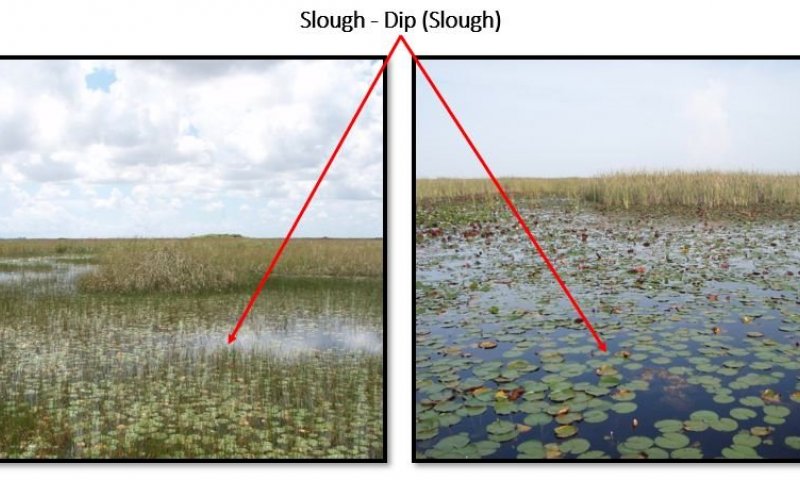
Figure 18. Representative slough march characterized by floating emergents and open water.
Sloughs are the deepest drainageways within swamps and marsh systems. They are broad channels inundated with slow moving or nearly stagnant water, except during extreme droughts. The vegetation structure is variable with some sloughs dominated by floating aquatics, others by large emergent herbs, and still others by a low or sparse canopy. The water in these dips\sloughs is slow moving, and sloughs may dry completely during droughts. Under natural conditions these areas exhibit longer hydroperiods (6 to 11 months). In south Florida, submerged plants and algae (including cyanobacteria, known as periphyton, found in more alkaline waters) can form mats in sloughs that contribute food and oxygen.
Characteristics and indicators. Under natural conditions these areas exhibit longer hydroperiods (6 to 11 months), the vegetation is dominated by floating aquatics, others by large emergent herbs, and still others by a low or sparse canopy. During extended periods of droughts these areas become a refuge for wildlife.
Resilience management. Maintain the natural drainage and surface water flow that sustained a adequate balance of ponding levels, duration and soil saturation. These areas are sensitive to fire and don't benefit from prescribe fire.
Dominant plant species
-
pond cypress (Taxodium ascendens), tree
-
pond apple (Annona glabra), tree
-
coastal plain willow (Salix caroliniana), shrub
-
common buttonbush (Cephalanthus occidentalis), shrub
-
giant cutgrass (Zizaniopsis miliacea), grass
-
Gulf Coast spikerush (Eleocharis cellulosa), other herbaceous
-
American white waterlily (Nymphaea odorata), other herbaceous
-
bladderwort (Utricularia), other herbaceous
-
pickerelweed (Pontederia cordata), other herbaceous
-
lizard's tail (Saururus cernuus), other herbaceous
-
bulltongue arrowhead (Sagittaria lancifolia), other herbaceous
Dominant resource concerns
State 3
Drained Pastureland
The land use on these areas are known as improve pastures areas and are mainly dedicated to the cattle industry. The major impact of the drained areas for cattle is soil subsidence due to the oxidation of the Sapric Soils materials. However, when these areas are well maintained these pastures contribute to the native plant and animal habitat as well as aquifer recharge. Birds and other wildlife thrive on lands used for cattle production. These areas require water management to control seasonal flooding of the fields; presence of drainages ditches and canals are abundant. These canals act as a water source for the cattle and as wildlife refuge. These pastures are open and have few to no trees, with existing trees (primarily oak and palms) serving as areas for shade.
Characteristics and indicators. Presence of drainages ditches and canals. Absence of Jamaica sawgrass (Cladium jamaicense). Land is leveled with none to few areas that can sustain herbaceous plants like Gulf Coast spikerush (Eleocharis cellulosa), American water lily (Nymphaea odorata), bladderworts (Utricularia spp.). Soil surface is not exposed and will be mainly covered by forage plants like Limpograss (Hemarthria altissima - introduced), St. Augustinegrass (Stenotaphrum secunda-tum - introduced), Maidencane (Panicum hemitomon - native), Blue Maidencane (Amphicarpum muhlenber-gianum - native).
Resilience management. To keep the pasture at a desirable stage these areas require water management to control seasonal flooding and ponding. A proper grazing plan is needed to prevent overgrazing and loss of the soil resource.
Dominant plant species
-
live oak (Quercus virginiana), tree
-
cabbage palmetto (Sabal palmetto), tree
-
limpograss (Hemarthria altissima), grass
-
St. Augustine grass (Stenotaphrum secundatum), grass
-
maidencane (Panicum hemitomon), grass
-
Muhlenberg maidencane (Amphicarpum muehlenbergianum), grass
-
Japanese millet (Echinochloa esculenta), grass
-
shyleaf (Aeschynomene americana), grass
-
crowngrass (Paspalum), grass
-
sedge (Abildgaardia), other herbaceous
-
tropical soda apple (Solanum viarum), other herbaceous
-
pigweed (Amaranthus), other herbaceous
Dominant resource concerns
-
Sheet and rill erosion
-
Wind erosion
-
Subsidence
-
Compaction
-
Organic matter depletion
-
Ponding and flooding
-
Seasonal high water table
-
Nutrients transported to surface water
-
Nutrients transported to ground water
-
Aquatic habitat for fish and other organisms
-
Inadequate livestock water quantity, quality, and distribution
State 4
Drained Horticulture Land
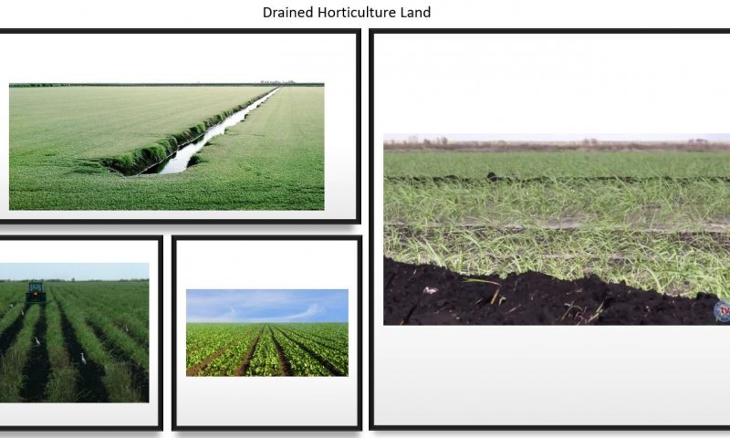
Figure 19. Drained Horticulture Land in the Everglades Agriculture Area.
These areas serve to provide cane sugar, grains and vegetables. These areas provide primarily winter vegetables including sweet corn, radishes, green beans, lettuce and other leafy greens, as well as rice and sugarcane. The areas have been drained and laser leveled to accommodate to the horticulture crops.
Characteristics and indicators. Presence of drainages ditches, water control structures, and canals. Absence of Jamaica sawgrass (Cladium jamaicense), Gulf Coast spikerush (Eleocharis cellulosa), American water lily (Nymphaea odorata), bladderworts (Utricularia spp.). Winter vegetables including sweet corn, radishes, green beans, lettuce and other leafy greens, as well as rice and sugarcane are commonly seen through the year. Parcels under rest or under crop rotation process will be artificially inundated to reduce soil subsidence. During the crop rotation or resting period if the area is not well maintain invasive plants like Cogon grass (Imperata cylindrica), Amaranthus (Amaranthus albus), Elephant grass ( Pennisetum purpureum), Higuereta (Ricinus communis), etc., can grow. Along the side of the canals banks if is not well maintained Brazilian peppertree (Schinus teredinthifolia) and Melaleuca (Melaleuca quinquenervia) can grow. Evidence of organic soil subsidence can be seen.
Resilience management. The hydrology of these areas are very resilient, if proper water control is not managed correctly these areas will remain inundated during the raining season causing the loss of the crops. If not controlled Typha (Typha sp.), Brazilian peppertree (Schinus teredinthifolia), and Melaleuca (Melaleuca quinquenervia) will grow at a fast rate suppressing the native vegetation.
Dominant resource concerns
-
Sheet and rill erosion
-
Wind erosion
-
Compaction
-
Organic matter depletion
-
Ponding and flooding
-
Seasonal high water table
-
Nutrients transported to surface water
-
Nutrients transported to ground water
-
Pesticides transported to surface water
-
Pesticides transported to ground water
State 5
Reconstructed Slough and Glades Marsh
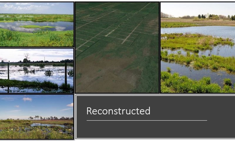
Figure 20. Reconstructed wetlands found in the WCA areas.
This state can be defined as the manipulation of a former or degraded wetland's physical, chemical, or biological characteristics to return its natural functions. The State 3: "Drained Pastureland" and State 4: "Drained Horticulture Land" can transition to this reconstructed state if the correct practices and management are put in place. Some general guiding principles are; Restore the natural function, restore natural structure, restore ecological integrity, restore native species avoiding non-native species, etc.
Characteristics and indicators. A reconstructed state will be easy to recognize through the landscape because it will create a boundary between two different habitat types. Wildlife diversity is greater along edges due to the different habitat types. After restoring the water flow from a drained condition to a more natural water flow and right ponding duration, the succession or progression of plant communities over time a freshwater marsh may gradually fill in with dense emergent and shrubs. Some invasive species (Melaleuca - Melaleuca quinquenervia, Brazilian pepper - Schinus terebinthifolia, and Cattail – Typha .spp) will grow. Areas with long to very long hydroperiods (6 to 11 months) will promote submerge and emergent vegetation, increasing the possibility of a slough vegetative community reestablishment. Glades marshes will require shorter hydroperiods but longer duration (6 to 9 months) and in many cases replanting is needed to speed up the reestablishment of the Jamaica sawgrass (Cladium jamaisence), suppress other type of grasses and aquatic emergent vegetation.
Dominant plant species
-
pond cypress (Taxodium ascendens), tree
-
Florida slash pine (Pinus elliottii var. densa), tree
-
cabbage palmetto (Sabal palmetto), tree
-
pond apple (Annona glabra), tree
-
coastal plain willow (Salix caroliniana), shrub
-
common buttonbush (Cephalanthus occidentalis), shrub
-
wax myrtle (Morella cerifera), shrub
-
Jamaica swamp sawgrass (Cladium mariscus ssp. jamaicense), grass
-
maidencane (Panicum hemitomon), grass
-
blue maidencane (Amphicarpum purshii), grass
-
wiregrass gentian (Gentiana pennelliana), grass
-
giant cutgrass (Zizaniopsis miliacea), grass
-
sedge (Abildgaardia), other herbaceous
-
sedge (Carex), other herbaceous
-
Gulf Coast spikerush (Eleocharis cellulosa), other herbaceous
-
American white waterlily (Nymphaea odorata), other herbaceous
-
yellow waterlily (Nymphaea mexicana), other herbaceous
-
bladderwort (Utricularia), other herbaceous
-
pickerelweed (Pontederia cordata), other herbaceous
-
lizard's tail (Saururus cernuus), other herbaceous
-
bulltongue arrowhead (Sagittaria lancifolia), other herbaceous
Dominant resource concerns
-
Wind erosion
-
Subsidence
-
Compaction
-
Organic matter depletion
-
Ponding and flooding
-
Nutrients transported to surface water
-
Nutrients transported to ground water
-
Wildfire hazard from biomass accumulation
-
Aquatic habitat for fish and other organisms
State 6
Human Transported or Human Altered Materials
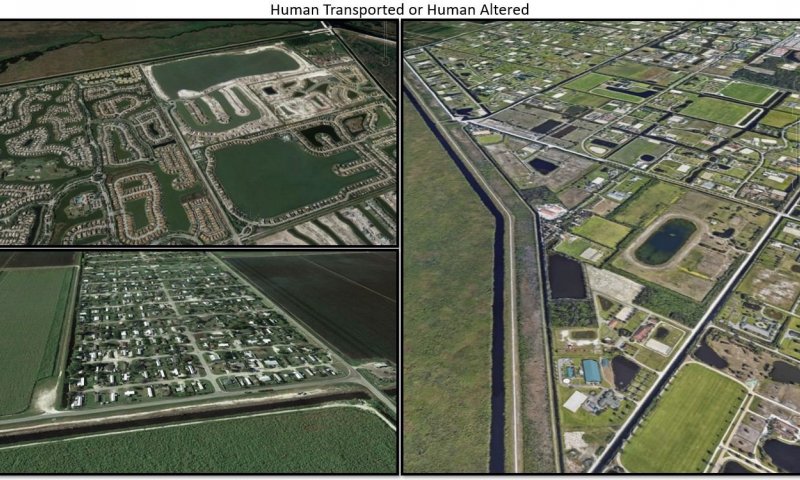
Figure 21. Human Transported or Human Altered Areas
Human Transported and Human Altered (HTHA) refer to all the vegetative communities that exist on soils that has been modified by anthropogenic activities. These HTHA areas are widespread across the MLRA 156A and are concentrated near where people live and work. These areas exist on soils that has been altered by humans. The two types of soils that fits this concept; Human-altered soils formed in human-altered materials from the soil surface to 50 cm (20 inches) (or to bedrock if shallower) or more, and human-transported soils formed in human-transported materials from the soil surface to 50 cm (20 inches) (or to bedrock if shallower) or more. The HTHA soils mainly occur in urban areas, transportation corridors, mined lands, landfills, filled shallow water, and agricultural areas on anthropogenic landforms. Dominant vegetation in areas well maintain will be ornamentals herbaceous and trees. Areas that aren’t well maintain will be overgrow by invasive grasses and trees. Reservoirs and anthropogenic ponded areas may support slough vegetation and can provide some wetland benefits. HTHA are extensive, and their extent is growing.
Characteristics and indicators. The existing vegetation will be located between sidewalks and roads, in home sites development, public gardens, botanical gardens, retention ponds, water reservoirs and parks. Areas with vegetation represent a percent of pervious surface that can range from 10 to 70 percent throughout the areas that people live and work. Landscapes are typically flat, with man made rises and knolls to elevate the surface above flood zones for home or urban development. Lower areas / depressions are often utilized for surface water control during the wet season.
Resilience management. Some open areas that were once altered and prepared for urban development that have been purchased by conservation programs exist, these areas are potential sites for restoration.
Dominant plant species
-
melaleuca (Melaleuca), tree
-
Florida slash pine (Pinus elliottii var. densa), tree
-
pond cypress (Taxodium ascendens), tree
-
royal palm (Roystonea regia), tree
-
cabbage palmetto (Sabal palmetto), tree
-
laurel oak (Quercus laurifolia), tree
-
water oak (Quercus nigra), tree
-
white cedar (Tabebuia heterophylla), tree
-
coconut palm (Cocos nucifera), tree
-
bucida (Bucida), tree
-
Brazilian peppertree (Schinus terebinthifolius), shrub
-
coco plum (Chrysobalanus icaco), shrub
-
seagrape (Coccoloba uvifera), shrub
-
castorbean (Ricinus communis), shrub
-
prostrate pigweed (Amaranthus albus), shrub
-
southern cattail (Typha domingensis), grass
-
St. Augustine grass (Stenotaphrum secundatum), grass
-
limpograss (Hemarthria altissima), grass
-
bahiagrass (Paspalum notatum), grass
-
cogongrass (Imperata cylindrica), grass
-
maidencane (Panicum hemitomon), grass
-
elephant grass (Pennisetum purpureum), grass
-
Gulf Coast spikerush (Eleocharis cellulosa), other herbaceous
-
American white waterlily (Nymphaea odorata), other herbaceous
-
bladderwort (Utricularia), other herbaceous
-
bulltongue arrowhead (Sagittaria lancifolia), other herbaceous
-
lizard's tail (Saururus cernuus), other herbaceous
-
pickerelweed (Pontederia cordata), other herbaceous
Dominant resource concerns
-
Wind erosion
-
Subsidence
-
Ponding and flooding
-
Seasonal high water table
-
Inefficient irrigation water use
-
Nutrients transported to surface water
-
Nutrients transported to ground water
-
Pesticides transported to surface water
-
Pesticides transported to ground water
-
Petroleum, heavy metals, and other pollutants transported to surface water
-
Petroleum, heavy metals, and other pollutants transported to ground water
-
Sediment transported to surface water
-
Terrestrial habitat for wildlife and invertebrates
-
Aquatic habitat for fish and other organisms
Transition T1A
State 1 to 2
The Glades Marshes can transition to a Slough due to wildfires if they occur when water levels are too low causing an entire burn of the Jamaica sawgrass (Cladium jamaisence). If the entire plant burns the surface sapric material (muck\ mucky peat) burns as well creating a lower depression or dip. When the water levels get back to normal, floating aquatics and others by large emergent herbs rapidly colonize and suppress the stressed Jamaica sawgrass. If hydroperiods are not properly balanced after a wildfire takes place the chance for Glades Marsh vegetation to recover are very low. Anthropogenic activities like hunting, airboat, and swam buggy activities contribute to the Jamaica sawgrass displacement and the Sloughs establishment by causing soil surface erosion. In dry seasons alligators may displace the vegetation creating a slough by creating gator holes to reach available water.
Constraints to recovery. Proper water levels control. Proper water flow. Removal of any anthropogenic activities. Dominant species replanting / recolonization. Control of wildlife. Surface erosion control.
Context dependence. Loss of sapric material due to fire, wildlife, and anthropogenic activities'. Hydroperiods elongation due to a change of the geomorphology of the area affected.
Transition T1B
State 1 to 3
The Glades Marshes state can transition to Drained Pastureland state by establishing water drainage control infrastructure. These practices include; constructing canals to drain the soils up to 20 inches (50 cm) from the surface, construction of water control gates to move the water from one parcel to another, removal of all native existing vegetation, land leveling, introduction of desirable forages to establish a pasture, and construction of roads.
Transition T1C
State 1 to 4
Drained Horticulture Land
The Glades Marshes state can transition to Drained Horticulture Land state by establishing water drainage control infrastructure. These practices include; constructing canals to drain the soils up to 20 inches (50 cm) from the surface, construction of water control gates to move the water from one parcel to another, removal of all native existing vegetation, land leveling, introduction of desirable commodity crops and construction of roads.
Restoration pathway R2A
State 2 to 1
To restore from a Slough to Glades Marshes, an effective water level and ponding period (approximately 6 to 9 months) needs to be established. Normally with a natural water flow reestablishment these conditions can be achieved. A reestablished hydroperiod will allow for the accumulation of new organic mater in the soil profile, raising the soil surface and creating suitable habitat for sawgrass growth. Wildlife (Alligator) control is needed to prevent eroding activities for nesting and gator habitat development (gator holes are commonly described as sloughs). Airboat activity needs to be suspended or monitored because the erosion to the soil surface and because the airboat friction can kill the grass. Reseeding and planting may be needed to increase the grass population, coverage, and grass thickness to suppress any other plants. An aggressive invasive plants control is needed to prevent or reduce the establishment of Typha sp. and Melaleuca (Melaleuca quinquenervia) plants.
Context dependence. Without the correct water flow, correct water levels, and ponding period (approximately 6 to 9 months), the chances of the Glades Marches to recover and thrive are low. The lack of wildlife, airboat, and invasive plants can encourage new Sawgrass growth. Because of the slow reestablishment of the sawgrass, if a reseeding and planting step is not added to the restoration effort the chance of other herbaceous vegetation take over are high.
Transition T2A
State 2 to 3
The Slough state can transition to Drained Pastureland state by establishing water drainage control infrastructure. These practices include; constructing canals to drain the soils up to 20 inches (50 cm) from the surface, construction of water control gates to move the water from one parcel to another, removal of all native existing vegetation, land leveling, introduction of desirable forages to establish a pasture, and construction of roads.
Transition T2B
State 2 to 4
Drained Horticulture Land
The Slough state can transition to Drained Horticulture Land state by establishing water drainage control infrastructure. These practices include; constructing canals to drain the soils up to 20 inches (50 cm) from the surface, construction of water control gates to move the water from one parcel to another, removal of all native existing vegetation, land leveling, introduction of desirable commodity crops and construction of roads.
Transition T3A
State 3 to 4
The Drained Pastureland can transition to Drained Horticulture Land state by the removal of all established forages and introduction of desirable commodity crops. Establishment of water drainage control infrastructure is needed if not already present. These practices include; constructing canals to drain the soils up to 20 inches (50 cm) from the surface, construction of water control gates to move the water from one parcel to another, and construction of roads.
Constraints to recovery. To recover or reconstruct back to a Drained Pastureland state from a Drained Horticulture Land state all commodity crops needs to be removed and all desirable forages will need to be reintroduced. Land leveling and keeping drainage control infrastructure is needed. An aggressive invasive species control program will need to be put in place to prevent the establishment of Typha (Typha sp.), Brazilian peppertree (Schinus teredinthifolia), and Melaleuca (Melaleuca quinquenervia).
Restoration pathway R3A
State 3 to 5
To reconstruct from a Drained Pastureland to a Reconstructed Slough and Glades Marsh state, the natural water flow and hydroperiod of the area needs to be restored. All water control and drainages infrastructure need to be removed. Landscape modification will be needed to mimic or simulate the original geomorphic positions to establish the correct hydroperiod durations of the Slough and Glades Marsh States. Replanting native vegetation may be needed.
Context dependence. Adequate water levels, mimic the correct hydroperiods duration, and establish a consistent invasive species control to reduce or eliminate the presence of grasses (forages and other invasive plants like Brazilian peppertree (Schinus teredinthifolia), Typha sp. and Melaleuca (Melaleuca quinquenervia). Establish reseeding and replanting procedures.
Transition T3B
State 3 to 6
To transition from a Drained Pastureland to a Human Transported or Human Altered state, a more aggressive water control and drainages infrastructure will be put in place. Land leveling will occur and will change the entire natural landscape. Most of the original vegetation will be removed. Transportation and removal of soils materials will occur to meet urban development needs. These practices will affect the natural physical, chemical and biological conditions of the soils affected. The percent of impervious surfaces will range from 0 % to 100 %. Dominant vegetation in areas that are well maintained will be ornamentals evergreen shrubs, ornamental herbaceous species, and trees. Areas that aren’t well maintained will be overgrow by native vegetation and invasive species. Reservoirs and anthropogenic ponded areas may support slough vegetation and can provide some wetland benefits.
Constraints to recovery. To recover or reconstruct to Drainage Horticulture Land, all desirable forages will need to be reintroduced. The land needs to be cleaned and free of any non-natural solid waste. All water control and drainages infrastructure will remain. An invasive species control program will need to be put in place to prevent the establishment of undesirable grasses, and other plants.
Transition T4A
State 4 to 3
To reconstruct from Drained Horticulture Land to Drained Pastureland, all commodity crops needs to be removed and the reintroduction of the desirable forages are needed. Water control and drainages infrastructure will remain. Minor land leveling and manipulation may be needed to promote the forage growth. An aggressive invasive species control program will need to be put in place to prevent the establishment of Typha (Typha sp.), Brazilian peppertree (Schinus teredinthifolia), and Melaleuca (Melaleuca quinquenervia).
Context dependence. Keep adequate water control and drainages infrastructure. Establish species control program to prevent the establishment of undesirable grasses (forages), and other plants.
Restoration pathway R4A
State 4 to 5
Drained Horticulture Land
Reconstructed Slough and Glades Marsh
To reconstruct from a Drained Horticulture Land to a Reconstructed Slough and Glades Marsh state, the natural water flow and hydroperiod of the area needs to be restored. All water control and drainages infrastructure need to be removed. Commodity crops will need to be removed, reseeding and replanting of desirable native species will be needed. Landscape modification will be needed to mimic or simulate the original geomorphic positions to establish the correct hydroperiod durations of the Slough and Glades Marsh States. Replanting native vegetation may be needed.
Context dependence. Adequate water levels, mimic the correct hydroperiods duration, and establish a consistent invasive species control to reduce or eliminate the presence of grasses (forages and other invasive plants like Brazilian peppertree (Schinus teredinthifolia), Typha sp. and Melaleuca (Melaleuca quinquenervia). Establish reseeding and replanting procedures.
Transition T4B
State 4 to 6
Drained Horticulture Land
Human Transported or Human Altered Materials
To transition from a Drained Horticulture Land to a Human Transported or Human Altered state, a more aggressive water control and drainages infrastructure will be put in place. Land leveling will occur and will change the entire natural landscape. Most of the original vegetation will be removed. Transportation and removal of soils materials will occur to meet urban development needs. These practices will affect the natural physical, chemical and biological conditions of the soils affected. The percent of impervious surfaces will range from 0 % to 100 %. Dominant vegetation in areas that are well maintained will be ornamentals evergreen shrubs, ornamental herbaceous species, and trees. Areas that aren’t well maintained will be overgrow by native vegetation and invasive species. Reservoirs and anthropogenic ponded areas may support slough vegetation and can provide some wetland benefits.
Constraints to recovery. To recover or reconstruct to a Drainage Horticulture Land, all desirable forages will need to be reintroduced. The land needs to be cleaned and free of any non-natural solid waste. All water control and drainages infrastructure will remain. An invasive species control program will need to be put in place to prevent the establishment of undesirable plants. Re introduce all the desirable commodity crops.
Context dependence. Keep adequate water control and drainages infrastructure. The land needs to be cleaned and free of any non-natural solid waste. All water control and drainages infrastructure will remain. Establish species control program to prevent the establishment of undesirable plants.
Restoration pathway R6A
State 6 to 5
Human Transported or Human Altered Materials
Reconstructed Slough and Glades Marsh
To reconstruct from a Human Transported or Human Altered state to a Reconstructed Slough and Glades Marsh state, the natural water flow and hydroperiod of the area needs to be restored. All water control and drainages infrastructure need to be removed. Urban structures will need to be removed, reseeding and replanting of desirable native species will be needed. Landscape modification will be needed to mimic or simulate the original geomorphic positions to establish the correct hydroperiod durations of the Slough and Glades Marsh States. Replanting native vegetation may be needed.
Context dependence. Adequate water levels, mimic the correct hydroperiods duration, and establish a consistent invasive species control to reduce or eliminate the presence of grasses (forages and other invasive plants like Brazilian peppertree (Schinus teredinthifolia), Typha sp. and Melaleuca (Melaleuca quinquenervia). Establish reseeding and replanting procedures. The land needs to be cleaned and free of any non-natural solid waste.