Natural Resources
Conservation Service
Ecological site R156AY500FL
Subaqueous Haline Estuarine Habitats of MLRA 156A
Last updated: 4/14/2025
Accessed: 04/12/2026
General information
Provisional. A provisional ecological site description has undergone quality control and quality assurance review. It contains a working state and transition model and enough information to identify the ecological site.
MLRA notes
Major Land Resource Area (MLRA): 156A–Florida Everglades and Associated Areas
This area makes up about 7,749 square miles (20,071 square kilometers) and is entirely in Florida. It is located at the southern tip of the State and has shoreline on both the Atlantic Ocean and the Gulf of America. Lake Okeechobee borders the MLRA to the north. Aside from sugar cane plantations in the north, the Everglades National Park, Big Cypress National Preserve, and the Big Cypress Seminole Indian Reservation comprise this area. Historical ditching, berming, and canals prevent natural water flow through this delicate ecosystem. To mitigate this, extensive restoration efforts have been implemented. Urban sprawl from Miami and cities to its north on the Atlantic Ridge has encroached along the eastern boundary of this area. Most of the MLRA has resisted urbanization because of a water table that is at or near the surface, a considerable acreage of unstable organic soils, and its identity as a national treasure.
About one-third of this area is in Native American reservations, national parks, game refuges, or other large holdings. Cypress forests are extensive in the area, but mangrove forests are widespread along the eastern and southern coasts. A large part of the area is open marsh. Much of the area is used for hunting, fishing, and other recreational activities. The cropland in the area is used mainly for winter vegetables, but citrus fruits, avocado, and papaya are grown on the better drained soils. Sugarcane is an important crop on the organic soils south of Lake Okeechobee. The acreage of improved pasture is increasing. Beef cattle are the principal kind of livestock, but dairying is an important enterprise locally. Urbanization is extensive along the eastern coast.
The major soil resource concerns are wind erosion, maintenance of the content of organic matter and productivity of the soils, and management of soil moisture and soil subsidence. Conservation practices on cropland generally include conservation crop rotations, cover crops, nutrient management, pest management, water-control structures, surface drainage systems (field ditches, mains, and laterals), pumping plants, and irrigation water management (including micro irrigation systems and surface and subsurface irrigation systems). Conservation practices on pasture and rangeland generally include prescribed grazing, brush management, pest management, prescribed burning, and watering facilities. Conservation practices on forestland generally include forest stand improvement, firebreaks, pest management, prescribed burning, and management of upland and wetland wildlife habitat.
LRU notes
There is not an official LRU for the MLRA 156A area. For the time being the technical team recommended to add the four physiographic provinces ecoregions to this section (Big Cypress, Everglades, Southern Coast and Islands, and Miami Ridge/ Atlantic Coastal Strip). This PES is a subaqueous ecological concept and not included in the physiographic ecoregions created by the EPA. For the time being we have created an unofficial ecoregion called the Coastal Marine and Estuarine Ecoregion.
The Coastal Marine and Estuarine Ecoregion is an unofficial ecoregion, which encompasses subaqueous habitats within this MLRA. It consists of subaqueous estuarine and marine habitats which are dominated by seagrass and algal beds, coral reefs, oyster beds, and unconsolidated substrates. These areas provide important habitat for marine life which is a major economic driver in the Florida Keys and along the Florida coast.
Classification relationships
All portions of the geographical range of this site falls under the following ecological / land classifications including:
-Environmental Protection Agency's Level 3 and 4 Ecoregions of Florida: 76 Southern Florida Coastal Plain (Griffith, G. E., Omernik, J. M., & Pierson, S. M., 2013)
-Florida Natural Area Inventory, 2010 Edition: Marine and Estuarine (FNAI ,2010)
-Everglades National Park Ecosystems, National Park Service: Marine and Estuarine (National Park Service, 2021)
-Biscayne National Park Ecosystems, National Park Service: Biscayne Bay, Seagrass Meadows (National Park Service, 2021)
-Big Cypress National Preserve, National Park Service: Estuaries (National Park Service, 2021)
Ecological site concept
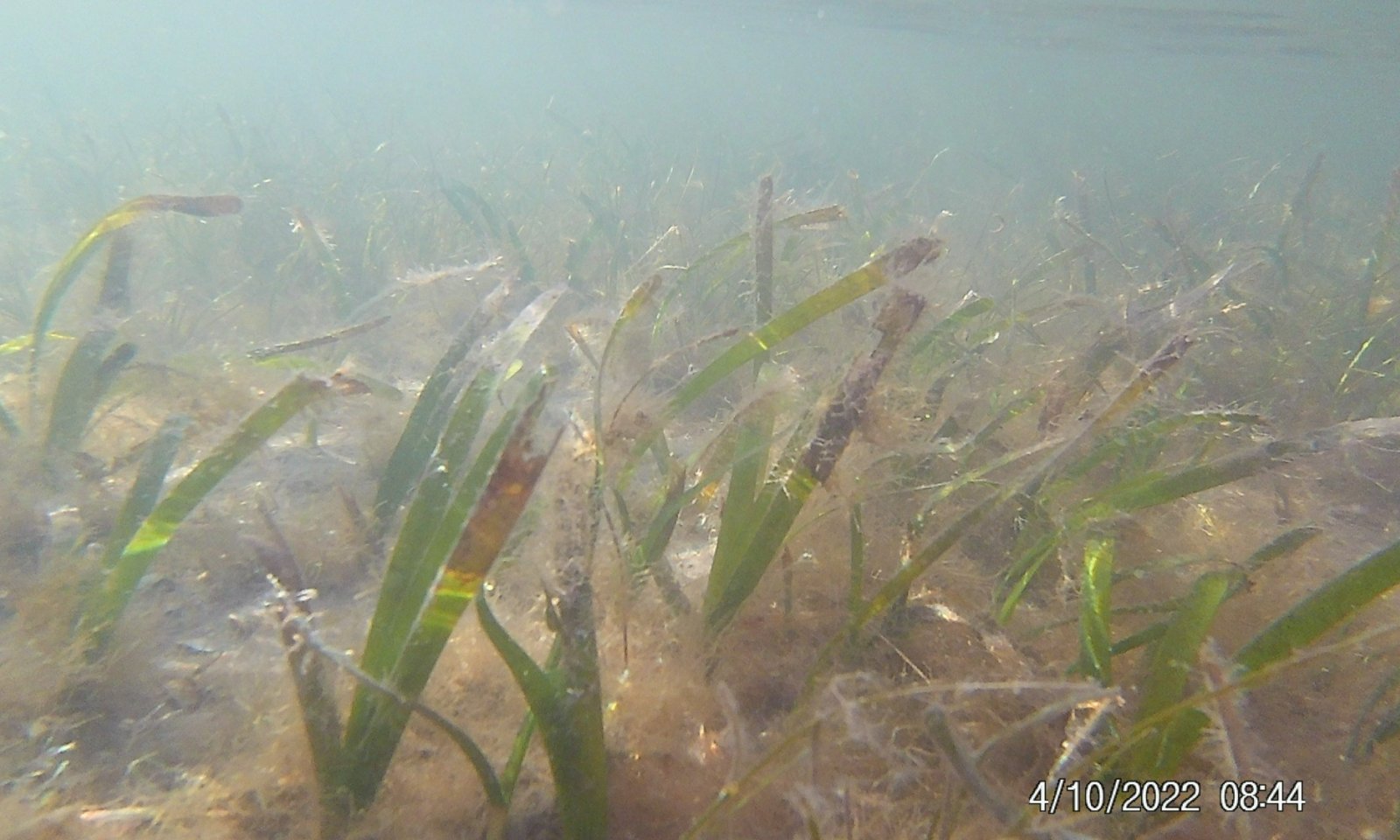
The Subaqueous Haline Estuarine Habitats are typically submerged sites found within subtidal zones. This site occurs in low energy areas (affected very little by wave energy, deposition of sandy material, or storm events). Water depths are variable but are characterized as semi-enclosed bodies of water but have open, partly obstructed, or sporadic access to the open ocean, in which water is at least occasionally diluted by freshwater runoff from the land. These sites are very fragile and susceptible to sea level rise and nutrient pollution. Native vegetation includes rooted and floating seagrass species, with cover ranging from 0 to 100%. This area is very important for recreational, commercial, and wildlife uses. Benthic fauna such as oysters, coral species, tubeworms, juvenile fish and crab species are often associated with this concept. Notable sites in this ecological site include Whitewater Bay and Florida Bay.
Associated sites
| R156AY310FL |
Subtropical Tidal Saline Wetlands of Miami Ridge/ Atlantic Coastal Strip The Subtropical Tidal Saline Wetlands of Miami Ridge / Atlantic Coastal Strip may be found as the ecotone to terrestrial landscapes in low wave energy intertidal areas as mangrove swamps, tidal marshes, or other intertidal areas within the Miami Ridge / Atlantic Coastal Strip ecoregion. |
|---|---|
| R156AY550FL |
Subaqueous Haline Marine Habitats of MLRA 156A The Subaqueous Haline Marine Habitats of MLRA 156A may be found in deeper, unprotected high wave energy systems. |
| R156AY110FL |
Subtropical Tidal Saline Wetlands of Southern Coast and Islands The Subtropical Tidal Saline Wetlands of Southern Coast and Islands may be found as the ecotone to terrestrial landscapes in low wave energy intertidal areas as mangrove swamps, tidal marshes, or other intertidal areas within the Southern Coast and Island ecoregion. |
Similar sites
| R156AY550FL |
Subaqueous Haline Marine Habitats of MLRA 156A The Subaqueous Haline Marine Habitats of MLRA 156A is mainly distinguished by the physiographic location of a marine system rather than an estuarine system. |
|---|
Table 1. Dominant plant species
| Tree |
Not specified |
|---|---|
| Shrub |
Not specified |
| Herbaceous |
(1) Halodule wrightii |


Click on box and path labels to scroll to the respective text.
Ecosystem states
| T1A | - | Dredging |
|---|---|---|
| T1B | - | Aquaculture Preparation |
| R2A | - | Fill and Replace Soil Material/ Seagrass Planting |
| T2A | - | Aquaculture Preparation |
| R3A | - | Fill and Replace Soil Material/ Seagrass Planting |
| T3A | - | Dredging |
State 1 submodel, plant communities
| 1.1A | - | Decrease in Water Quality |
|---|---|---|
| 1.1B | - | Decrease in Water Quality |
| 1.2A | - | Increase in Water Quality / Seagrass Replanting |
| 1.2B | - | Decrease in Water Quality |
| 1.3A | - | Increase in Water Quality / Seagrass Replanting |
State 2 submodel, plant communities
| 2.1A | - | Deposition of Spoil Material |
|---|