
Natural Resources
Conservation Service
Ecological site R220XY461AK
Maritime Scrub Sandy Depressions
Last updated: 6/05/2025
Accessed: 04/03/2026
General information
Provisional. A provisional ecological site description has undergone quality control and quality assurance review. It contains a working state and transition model and enough information to identify the ecological site.
MLRA notes
Major Land Resource Area (MLRA): 220X–Alexander Archipelago-Gulf of Alaska Coast
The Alexander Archipelago-Gulf of Alaska Coast area consists of a narrow arc of islands and lower elevation coastal mountains in the Southern Alaska Region. This area spans from the Alexander Archipelago in southeastern Alaska, north and west along the coast of the Gulf of Alaska and Prince William Sound, and further west to the southern tip of the Kenai Peninsula and the northeastern islands of the Kodiak Archipelago. The area makes up about 27,435 square miles (USDA 2006). The terrain primarily consists of low to moderate relief mountains that are deeply incised. Throughout the area glaciers, rivers, and streams have cut deep, narrow to broad valleys. The broader valleys have nearly level to strongly sloping flood plains and stream terraces. Alluvial and colluvial fans and short footslopes are common in the valleys along the base of the mountains. Rocky headlands, sea cliffs, estuaries, and beaches are common along the coast.
This area includes the Municipality of Juneau, Alaska's capital, and a number of smaller coastal towns and villages. Federally administered lands within this MLRA include Admiralty Island National Monument and part of Misty Fjords National Monument, Tongass National Forest, Chugach National Forest, and Glacier Bay, Wrangell-St. Elias, and Kenai Fjords National Parks and Preserves. The southern terminus of the Trans-Alaska Pipeline is in Valdez.
During the late Pleistocene epoch, the entire area was covered with glacial ice. The numerous fjords of the Alexander Archipelago and Prince William Sound were formed chiefly as a result of glacial scouring and deepening of preglacial river valleys. Most glacial deposits have been eroded away or buried by mountain colluvium and alluvium, which cover about 90 percent of the present landscape. The remaining glacial and glaciofluvial deposits are generally restricted to coastal areas. During the Holocene epoch, volcanic activity within and adjacent to this area deposited a layer of volcanic ash of varying thickness on much of the landscape in the southeastern and northwestern parts of the area. Paleozoic, Mesozoic, and Lower Tertiary stratified sedimentary rocks and Cretaceous and Tertiary intrusive rocks underlie much of the area and are exposed on steep mountain
slopes and ridges (USDA 2006).
The dominant soil orders in this MLRA are Spodosols, Histosols, and Entisols. Soils in the area typically have a cryic soil temperature regime, an udic moisture regime, and have mixed minerology. Spodosols are common on mountains and hills having been formed in gravelly or cobbly colluvium, glacial till, and varying amounts of silty volcanic ash. These Spodosols commonly range from shallow to deep, are well to somewhat poorly drained, and typically classify as Humicryods or Haplocryods. Histosols that are poorly to very poorly drained occur on footslopes, discharge slopes, and valley floors. These wet histosols commonly classify as Cryosaprists, Cryohemists, and Cryofibrists. Histosols that are well drained occur on steep mountainsides. These dry Histosols commonly classify as Cryofolists. Entisols are common on flood plains, stream terraces, and outwash plains having been formed in silty, sandy, and gravelly to cobbly alluvium. These Entisols are generally deep, range from well to somewhat poorly drained, and commonly classify as Cryaquents and Cryofluvents. Miscellaneous (non-soil) areas make up about 23 percent of the MLRA. The most common miscellaneous areas are avalanche chutes, rock outcrop, rubble land, beaches, river wash, and water.
This area represents the northern extent of the Pacific temperate rainforest and is characterized by productive stands of conifers. Western hemlock and Sitka spruce are the dominant trees on mountains and hills at the lower elevations. Due to warmer temperatures, western red cedar and Alaska cedar are more prevalent in the southern part of the area. Black cottonwood and mixed forest types occur on flood plains. Areas of peat and other sites that are too wet for forest growth support sedge-grass meadows and low scrub. The transition to subalpine and alpine communities typically occurs at elevations between 1500 to 3000 feet (Boggs et al. 2010, Carstensen 2007, Martin et al. 1995), which characterize the vegetation of the Southern Alaska Coastal Mountains area.
For many decades, logging, commercial fishing, and mining have been the primary industrial land uses throughout much of the area. In recent years, changes in public interests, land use policies, and timber economics have contributed to a significant decline in the timber industry. Commercial fishing continues to be an important industry and most communities support a fleet of boats and fishing related facilities. A number of mines operate in the area and others have been prospected and proposed. Tourism and wildland recreation are becoming increasingly important. Subsistence hunting, fishing, and gathering provide food and a variety of other resources to local residents and remain the principal economy for residents of remote villages.
Ecological site concept
This site occurs in ponded depressions in a variety of landscapes and landforms with deep, coarse-textured soils. In all settings, the water table ranges from several inches above the soil surface (ponded) to 4 inches below the soil surface. These soils are very poorly drained and nutrient poor.
The reference state supports an open low scrubland dominated by sweet gale and a wet herbaceous community dominated by horsetails (Equisetum spp.) and sedges (Carex spp.). Diverse water-loving plants are present in both communities, with wetness as the primary driver of shrub cover. Landform position influences community location, with horsetails in lower areas and shrubs in relatively higher spots. Concurrently, sweet gale and other shrubs are more abundant during relatively dry periods and less abundant when during relatively wet periods.
Associated sites
| F220XY466AK |
Maritime Forest Sandy Plains Eolian Site F220XY466AK occurs on eolian hills and dunes and can be adjacent to depressions or dune slacks associated with site R220XY461AK. However, site F220XY466AK is not subject to ponding and supports closed coniferous forest. |
|---|---|
| F220XY455AK |
Maritime Forest Sandy Coastal Plain Site F220XY455AK occurs on outwash plains and deltas and can be adjacent to depressions associated with site R220XY461AK. However, site F220XY455AK is not subject to ponding and supports open forest vegetation. |
| F220XY460AK |
Maritime Forest Gravelly Alluvial Plains Site F220XY460AK occurs on terraces and can be adjacent to depressions associated with site R220XY461AK. However site F220XY460AK is not subject to ponding and supports an open coniferous forest. |
| F220XY432AK |
Maritime Forest Gravelly Plain Site F220XY432AK occurs on outwash plains and deltas and can be adjacent to depressions associated with site R220XY461AK. However, site F220XY432AK is not subject to ponding and supports open forest vegetation. |
| F220XY435AK |
Maritime Forest Loamy Wet Plains Site F220XY435AK occurs on outwash plains and deltas and can be adjacent to depressions associated with site R220XY461AK. However, site F220XY435AK is not subject to ponding and supports open forest vegetation. |
Similar sites
| F220XY455AK |
Maritime Forest Sandy Coastal Plain Site F220XY455AK occurs in similar landscape positions, however, it differs from this site because it is not frequently ponded on the soil surface for long periods. Site F220XY455AK is poorly or somewhat-poorly drained and can support an open forest community, whereas this site is very poorly-drained and is too wet to support forest communities. |
|---|
Table 1. Dominant plant species
| Tree |
Not specified |
|---|---|
| Shrub |
(1) Myrica gale |
| Herbaceous |
(1) Equisetum variegatum |
Physiographic features
This site occurs in coarse-textured wet depressions that are frequently ponded and very poorly drained. These depressions occur on a variety of landscapes and landforms, including outwash plains, alluvial plains, outwash deltas, dune slacks, and fluviomarine terraces. In all settings, the water table ranges from several inches above the soil surface (ponded) to 4 inches below the soil surface throughout the growing season. This site is found at elevations of 0 - 700 feet on slopes ranging from 0 - 3%.
Table 2. Representative physiographic features
| Geomorphic position, flats |
(1) Dip |
|---|---|
| Landforms |
(1)
Outwash plain
> Depression
(2) Alluvial plain > Depression (3) Shore complex > Dune slack (4) Outwash plain > Outwash delta (5) Shore complex > Fluviomarine terrace |
| Runoff class | Very low to low |
| Flooding duration | Brief (2 to 7 days) |
| Flooding frequency | Rare to occasional |
| Ponding duration | Long (7 to 30 days) to very long (more than 30 days) |
| Ponding frequency | Frequent |
| Elevation | 700 ft |
| Slope | 3% |
| Ponding depth | 6 in |
| Water table depth | 4 in |
| Aspect | W, NW, N, NE, E, SE, S, SW |
Table 3. Representative physiographic features (actual ranges)
| Runoff class | Very low to low |
|---|---|
| Flooding duration | Brief (2 to 7 days) |
| Flooding frequency | None to occasional |
| Ponding duration | Long (7 to 30 days) to very long (more than 30 days) |
| Ponding frequency | Frequent |
| Elevation | 700 ft |
| Slope | 3% |
| Ponding depth | 6 in |
| Water table depth | 4 in |
Climatic features
Cloudy skies, moderate temperatures, and abundant rainfall characterize the temperate maritime climate of this site. Frequent winter storms may consist of snow or heavy rainfall. Moderate to strong winds from the south and southeast are common before and during storms throughout the year. Annual precipitation ranges from 44-94 inches, and annual snowfall ranges from 30-70 inches along the coast and up to 200 inches at higher elevations (USDA 2006). The average annual temperature at lower elevations ranges from about 38-43 degrees F (3-6 degrees C). The frost-free period ranges from about 90-140 days, and the freeze-free period ranges from about 125-180 days.
Table 4. Representative climatic features
| Frost-free period (characteristic range) | 95-142 days |
|---|---|
| Freeze-free period (characteristic range) | 147-183 days |
| Precipitation total (characteristic range) | 55-145 in |
| Frost-free period (actual range) | 84-170 days |
| Freeze-free period (actual range) | 119-218 days |
| Precipitation total (actual range) | 35-172 in |
| Frost-free period (average) | 120 days |
| Freeze-free period (average) | 168 days |
| Precipitation total (average) | 97 in |
Figure 1. Monthly precipitation range
Figure 2. Monthly minimum temperature range
Figure 3. Monthly maximum temperature range
Figure 4. Monthly average minimum and maximum temperature
Figure 5. Annual precipitation pattern
Figure 6. Annual average temperature pattern
Climate stations used
-
(1) CORDOVA M K SMITH AP [USW00026410], Cordova, AK
-
(2) SITKA AIRPORT [USW00025333], Sitka, AK
-
(3) JUNEAU INTL AP [USW00025309], Juneau, AK
-
(4) ANNETTE ISLAND AP [USW00025308], Metlakatla, AK
-
(5) PETERSBURG 1 [USW00025329], Petersburg, AK
-
(6) KETCHIKAN INTL AP [USW00025325], Ketchikan, AK
-
(7) PELICAN [USC00507141], Hoonah, AK
-
(8) GUSTAVUS [USW00025322], Gustavus, AK
-
(9) GLACIER BAY [USC00503294], Gustavus, AK
-
(10) YAKUTAT STATE AP [USW00025339], Yakutat, AK
-
(11) SKAGWAY AP [USW00025335], Skagway, AK
-
(12) HAINES AP [USW00025323], Haines, AK
-
(13) SELDOVIA AP [USW00025516], Homer, AK
-
(14) MAIN BAY [USC00505604], Valdez, AK
Influencing water features
The hydrology of this site is characterized by saturated soil conditions and a water table just below or several inches above (ponded) the soil surface throughout the growing season. Since it occurs in depressions near the bottom of a watershed, this site accumulates water flowing into it as runoff and subsurface flow from adjacent sites upslope. This site discharges water slowly due to its low slope and concave surface topography.
Soil features
The soils of this site formed in deep, coarse-textured outwash, alluvium, or eolian sand deposits greater than 60 inches thick. These soils are very poorly drained and have an aquic soil moisture regime. Soil textures are typically sandy with very few rock fragments, and may be capped with a mucky peat organic layer or a loamy- to silty-textured mineral layer on the surface. These soils are nutrient poor, with low clay content, low calcium carbonate content, and neutral to moderately acidic pH.
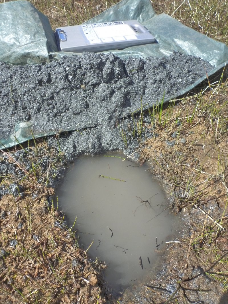
Figure 7. Typical soil profile.
Table 5. Representative soil features
| Parent material |
(1)
Outwash
(2) Alluvium (3) Eolian sands |
|---|---|
| Surface texture |
(1) Sandy loam (2) Mucky peat (3) Silt loam (4) Peat (5) Muck |
| Family particle size |
(1) Sandy (2) Loamy (3) Fine-silty (4) Coarse-loamy |
| Drainage class | Very poorly drained |
| Permeability class | Moderately rapid to very rapid |
| Soil depth | 60 in |
| Surface fragment cover <=3" | Not specified |
| Surface fragment cover >3" | Not specified |
| Available water capacity (0-40in) |
4 – 10.4 in |
| Calcium carbonate equivalent (0-40in) |
Not specified |
| Clay content (0-20in) |
10% |
| Electrical conductivity (0-40in) |
Not specified |
| Sodium adsorption ratio (0-40in) |
Not specified |
| Soil reaction (1:1 water) (0-10in) |
3.5 – 7.5 |
| Subsurface fragment volume <=3" (0-60in) |
Not specified |
| Subsurface fragment volume >3" (0-60in) |
Not specified |
Table 6. Representative soil features (actual values)
| Drainage class | Very poorly drained |
|---|---|
| Permeability class | Moderately rapid to very rapid |
| Soil depth | 60 in |
| Surface fragment cover <=3" | Not specified |
| Surface fragment cover >3" | Not specified |
| Available water capacity (0-40in) |
0.9 – 10.9 in |
| Calcium carbonate equivalent (0-40in) |
5% |
| Clay content (0-20in) |
24% |
| Electrical conductivity (0-40in) |
Not specified |
| Sodium adsorption ratio (0-40in) |
Not specified |
| Soil reaction (1:1 water) (0-10in) |
3 – 8.3 |
| Subsurface fragment volume <=3" (0-60in) |
18% |
| Subsurface fragment volume >3" (0-60in) |
Not specified |
Ecological dynamics
This site occurs in ponded depressions on a variety of landscapes and landforms with coarse-textured soils. Saturated soils and ponding are the primary ecological drivers on this site. Climate trends, weather events, and hydrologic changes higher up in the watershed all contribute to the ecosystem dynamics observed on this site. The soil is saturated for most of the growing season, often with ponding. As a result, all species common to this site are hydrophytes and are often obligate wetland species. The relative dominance of shrubs is a function of soil wetness and ponding, with sweet gale as the primary indicator of relatively dry hydrology on this site. Micro features resulting from topographic complexity as well as seasonal changes in water inputs may lead to areas within or around depressions that are relatively drier than others.
Browsing by moose on willow species was observed on this ecological site, but it does not appear to affect the ecological processes enough to alter the communities.
State and transition model
More interactive model formats are also available.
View Interactive Models
Click on state and transition labels to scroll to the respective text
Ecosystem states
State 1 submodel, plant communities
| 1.1a | - | Longer duration and/or more frequent ponding |
|---|---|---|
| 1.2a | - | Shorter duration and/or less frequent ponding |
State 1
Reference State

The reference state supports two community phases. The reference community phase is an open low scrubland consisting of low and dwarf shrubs interspersed with areas of water-loving forbs and graminoids. If site wetness increases, the shrub component of the community decreases, particularly sweet gale, and is replaced by a wet forb herbaceous community dominated by horsetails (Equisetum ssp.) and sedges (Carex ssp.).
Resilience management. This state has been observed to be resilient and/or resistant to current disturbance drivers, lacking alternative states and at-risk communities.
Dominant plant species
-
sweetgale (Myrica gale), shrub
-
sedge (Carex), grass
-
horsetail (Equisetum), other herbaceous
Community 1.1
Sweetgale / horsetail
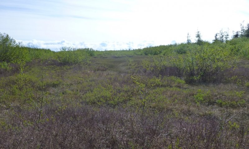
Figure 8. Typical plant community associated with community 1.1.
The reference community phase is characterized as open scrubland (Viereck et al. 1992) that includes patchy, dense shrubs in a mosaic of wetland graminoids and forbs. Sweetgale is the best indicator of this plant community, along with equisetum species and purple marshlocks. Diverse willows, sedges, and wetland forbs are common. The vegetative strata that characterize this community is medium shrubs (3 feet to 10 feet in height) and medium forbs (4 inches to 2 feet in height). Soil surface cover is a highly variable combination of herbaceous litter, moss, bare soil, and water.
Resilience management. This phase has been observed to be resilient and/or resistant to current disturbance drivers, lacking alternative states and at-risk communities.
Dominant plant species
-
sweetgale (Myrica gale), shrub
-
horsetail (Equisetum), other herbaceous
Table 7. Soil surface cover
| Tree basal cover | 0% |
|---|---|
| Shrub/vine/liana basal cover | 0% |
| Grass/grasslike basal cover | 0% |
| Forb basal cover | 0% |
| Non-vascular plants | 0-90% |
| Biological crusts | 0% |
| Litter | 40-100% |
| Surface fragments >0.25" and <=3" | 0% |
| Surface fragments >3" | 0% |
| Bedrock | 0% |
| Water | 0-65% |
| Bare ground | 0-45% |
Community 1.2
horsetail / sedge
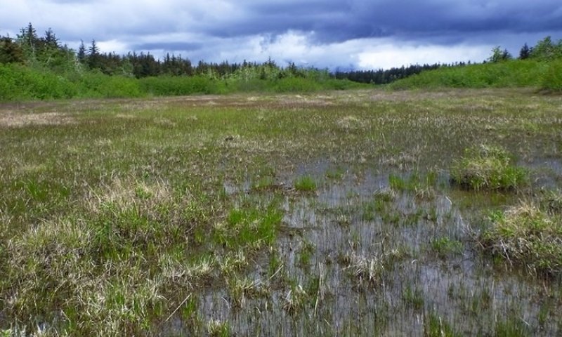
Figure 9. Typical plant community associated with community 1.2.
This is a wet forb herbaceous community (Viereck et al. 1992) with diverse hydrophytic forbs, graminoids, willows, and mosses. Equisetum spp. and Carex spp. are particularly dominant. The vegetative stratum that characterizes this community is medium forbs (4 to 24 inches in height ). Soil surface cover is a highly variable combination of herbaceous litter, moss, bare soil, and water.
Resilience management. This phase has been observed to be resilient and/or resistant to current disturbance drivers, lacking alternative states and at-risk communities.
Table 8. Soil surface cover
| Tree basal cover | 0% |
|---|---|
| Shrub/vine/liana basal cover | 0% |
| Grass/grasslike basal cover | 0% |
| Forb basal cover | 0% |
| Non-vascular plants | 0-95% |
| Biological crusts | 0% |
| Litter | 5-80% |
| Surface fragments >0.25" and <=3" | 0% |
| Surface fragments >3" | 0% |
| Bedrock | 0% |
| Water | 5-90% |
| Bare ground | 0-30% |
Pathway 1.1a
Community 1.1 to 1.2
Ecological process: increased ponding reduces bioavailability of soil nutrients due to the lack of oxygen, thereby reducing cover of woody shrubs like sweet gale in favor of sedge and equisetum which are better adapted to extended periods of soil saturation. Trigger: increased wetness due to weather, climate, or hydrologic change in the watershed such as tree removal upslope that reduces evapotranspiration and increases discharge to concave landscape positions.
Pathway 1.2a
Community 1.2 to 1.1
Ecological process: decreased ponding increases the bioavailability of soil nutrients due to the presence of oxygen, thereby increasing cover of woody shrubs like sweet gale. Trigger: Decreased wetness due to weather, climate, or hydrologic change in the watershed, such as a road that impedes water flow to concave areas due to insufficient culverts.
Additional community tables
Table 9. Community 1.1 forest understory composition
| Common name | Symbol | Scientific name | Nativity | Height (ft) | Canopy cover (%) | |
|---|---|---|---|---|---|---|
|
Grass/grass-like (Graminoids)
|
||||||
| Lyngbye's sedge | CALY3 | Carex lyngbyei | Native | – | 0–40 | |
| longawn sedge | CAMA11 | Carex macrochaeta | Native | – | 0–20 | |
| water sedge | CAAQ | Carex aquatilis | Native | – | 0–20 | |
| bluejoint | CACA4 | Calamagrostis canadensis | Native | – | 0–20 | |
| Graminoid (grass or grass-like) | 2GRAM | Graminoid (grass or grass-like) | Native | – | 0–15 | |
| red cottongrass | ERRU2 | Eriophorum russeolum | Native | – | 0–15 | |
| sweetgrass | HIOD | Hierochloe odorata | Native | – | 0–15 | |
| tall cottongrass | ERAN6 | Eriophorum angustifolium | Native | – | 0–10 | |
| Chamisso's cottongrass | ERCH7 | Eriophorum chamissonis | Native | – | 0–10 | |
| tufted hairgrass | DECE | Deschampsia cespitosa | Native | – | 0–10 | |
| falcate rush | JUFA | Juncus falcatus | Native | – | 0–6 | |
| poverty rush | JUTE | Juncus tenuis | Native | – | 0–5 | |
| three-hulled rush | JUTR4 | Juncus triglumis | Native | – | 0–3 | |
| red fescue | FERU2 | Festuca rubra | Native | – | 0–3 | |
| white cottongrass | ERSC2 | Eriophorum scheuchzeri | Native | – | 0–3 | |
| northern green rush | JUALN | Juncus alpinoarticulatus ssp. nodulosus | Native | – | 0–2 | |
| arctic rush | JUAR2 | Juncus arcticus | Native | – | 0–2 | |
| common woodrush | LUMU2 | Luzula multiflora | Native | – | 0–2 | |
| smallflowered woodrush | LUPA4 | Luzula parviflora | Native | – | 0–2 | |
| slimstem reedgrass | CAST36 | Calamagrostis stricta | Native | – | 0–2 | |
| little green sedge | CAVI5 | Carex viridula | Native | – | 0–2 | |
| boreal bog sedge | CAMA12 | Carex magellanica | Native | – | 0–2 | |
| mud sedge | CALI7 | Carex limosa | Native | – | 0–2 | |
| tufted bulrush | TRCE3 | Trichophorum cespitosum | Native | – | 0–1 | |
| yellow sedge | CAFL4 | Carex flava | Native | – | 0–1 | |
|
Forb/Herb
|
||||||
| yellow marsh marigold | CAPA5 | Caltha palustris | Native | – | 0–50 | |
| buckbean | METR3 | Menyanthes trifoliata | Native | – | 0–25 | |
| western water hemlock | CIDO | Cicuta douglasii | Native | – | 0–15 | |
| purple marshlocks | COPA28 | Comarum palustre | Native | – | 1–15 | |
| marsh pea | LAPA4 | Lathyrus palustris | Native | – | 0–10 | |
| alpine bistort | POVI3 | Polygonum viviparum | Native | – | 0–8 | |
| marsh grass of Parnassus | PAPA8 | Parnassia palustris | Native | – | 0–6 | |
| smallflower lousewort | PEPA4 | Pedicularis parviflora | Native | – | 0–5 | |
| Alaska Indian paintbrush | CAUN4 | Castilleja unalaschcensis | Native | – | 0–5 | |
| white marsh marigold | CALE4 | Caltha leptosepala | Native | – | 0–5 | |
| giant red Indian paintbrush | CAMI12 | Castilleja miniata | Native | – | 0–5 | |
| bog blueberry | VAUL | Vaccinium uliginosum | Native | – | 0–5 | |
| American vetch | VIAM | Vicia americana | Native | – | 0–4 | |
| little yellow rattle | RHMI13 | Rhinanthus minor | Native | – | 0–4 | |
| goose tongue | PLMAJ | Plantago maritima var. juncoides | Native | – | 0–3 | |
| kneeling angelica | ANGE2 | Angelica genuflexa | Native | – | 0–3 | |
| seacoast angelica | ANLU | Angelica lucida | Native | – | 0–3 | |
| silverweed cinquefoil | ARAN7 | Argentina anserina | Native | – | 0–3 | |
| threeleaf goldthread | COTR2 | Coptis trifolia | Native | – | 0–3 | |
| violet | VIOLA | Viola | Native | – | 0–3 | |
| Douglas aster | SYSUS | Symphyotrichum subspicatum var. subspicatum | Native | – | 0–3 | |
| sticky tofieldia | TRGL5 | Triantha glutinosa | Native | – | 0–2 | |
| hooded lady's tresses | SPRO | Spiranthes romanzoffiana | Native | – | 0–2 | |
| burnet | SANGU2 | Sanguisorba | Native | – | 0–2 | |
| common yarrow | ACMI2 | Achillea millefolium | Native | – | 0–2 | |
| beachhead iris | IRSE | Iris setosa | Native | – | 0–2 | |
| threepetal bedstraw | GATR2 | Galium trifidum | Native | – | 0–2 | |
| arctic eyebright | EUSU2 | Euphrasia subarctica | Native | – | 0–1 | |
| scentbottle | PLDI3 | Platanthera dilatata | Native | – | 0–1 | |
| bentgrass | AGROS2 | Agrostis | Native | – | 0–1 | |
| showy pussytoes | ANPU | Antennaria pulcherrima | Native | – | 0–1 | |
| roundleaf sundew | DRRO | Drosera rotundifolia | Native | – | 0–1 | |
| Pacific hemlockparsley | COGM | Conioselinum gmelinii | Native | – | 0–1 | |
| Canadian burnet | SACA14 | Sanguisorba canadensis | Native | – | 0–1 | |
| felwort | SWPE | Swertia perennis | Native | – | 0–1 | |
| Rocky Mountain goldenrod | SOMU | Solidago multiradiata | Native | – | 0–1 | |
| white clover | TRRE3 | Trifolium repens | Native | – | 0–1 | |
| small cranberry | VAOX | Vaccinium oxycoccos | Native | – | 0–1 | |
|
Fern/fern ally
|
||||||
| variegated scouringrush | EQVA | Equisetum variegatum | Native | – | 5–80 | |
| water horsetail | EQFL | Equisetum fluviatile | Native | – | 1–70 | |
| field horsetail | EQAR | Equisetum arvense | Native | – | 0–60 | |
| scouringrush horsetail | EQHY | Equisetum hyemale | Native | – | 0–20 | |
| marsh horsetail | EQPA | Equisetum palustre | Native | – | 0–7 | |
|
Shrub/Subshrub
|
||||||
| sweetgale | MYGA | Myrica gale | Native | – | 10–85 | |
| undergreen willow | SACO2 | Salix commutata | Native | – | 1–40 | |
| Barclay's willow | SABA3 | Salix barclayi | Native | – | 1–15 | |
| dune willow | SAHO | Salix hookeriana | Native | – | 0–10 | |
| Sitka willow | SASI2 | Salix sitchensis | Native | – | 0–5 | |
| Sitka alder | ALVIS | Alnus viridis ssp. sinuata | Native | – | 0–5 | |
| arctic raspberry | RUAR | Rubus arcticus | Native | – | 0–3 | |
| cloudberry | RUCH | Rubus chamaemorus | Native | – | 0–3 | |
| false mountain willow | SAPS | Salix pseudomonticola | Native | – | 0–3 | |
| grayleaf willow | SAGL | Salix glauca | Native | – | 0–1 | |
|
Tree
|
||||||
| Sitka spruce | PISI | Picea sitchensis | Native | – | 0–7 | |
| lodgepole pine | PICO | Pinus contorta | Native | – | 0–5 | |
|
Nonvascular
|
||||||
| calliergon moss | CALLI10 | Calliergon | Native | – | 0–95 | |
| calliergonella moss | CACU18 | Calliergonella cuspidata | Native | – | 0–70 | |
| Moss | 2MOSS | Moss | Native | – | 0–60 | |
| goose neck moss | RHYTI2 | Rhytidiadelphus | Native | – | 0–60 | |
| dichodontium moss | DIPE7 | Dichodontium pellucidum | Native | – | 0–50 | |
| goose neck moss | RHLO70 | Rhytidiadelphus loreus | Native | – | 0–20 | |
| rhizomnium moss | RHIZO2 | Rhizomnium | Native | – | 0–15 | |
| rhizomnium moss | RHGL70 | Rhizomnium glabrescens | Native | – | 0–10 | |
| sphagnum | SPHAG2 | Sphagnum | Native | – | 0–10 | |
| felt lichen | PELTI2 | Peltigera | Native | – | 0–1 | |
Table 10. Community 1.2 forest understory composition
| Common name | Symbol | Scientific name | Nativity | Height (ft) | Canopy cover (%) | |
|---|---|---|---|---|---|---|
|
Grass/grass-like (Graminoids)
|
||||||
| water sedge | CAAQ | Carex aquatilis | Native | – | 0–50 | |
| Lyngbye's sedge | CALY3 | Carex lyngbyei | Native | – | 0–35 | |
| sedge | CAREX | Carex | Native | – | 0–25 | |
| little green sedge | CAVI5 | Carex viridula | Native | – | 0–20 | |
| bluejoint | CACA4 | Calamagrostis canadensis | Native | – | 0–20 | |
| red cottongrass | ERRU2 | Eriophorum russeolum | Native | – | 0–20 | |
| lesser panicled sedge | CADI4 | Carex diandra | Native | – | 0–10 | |
| Chamisso's cottongrass | ERCH7 | Eriophorum chamissonis | Native | – | 0–5 | |
| rush | JUNCU | Juncus | Native | – | 0–3 | |
| northern green rush | JUALN | Juncus alpinoarticulatus ssp. nodulosus | Native | – | 0–2 | |
| tufted hairgrass | DECE | Deschampsia cespitosa | Native | – | 0–2 | |
| tall cottongrass | ERAN6 | Eriophorum angustifolium | Native | – | 0–1 | |
| bentgrass | AGROS2 | Agrostis | Native | – | 0–1 | |
| slimstem reedgrass | CAST36 | Calamagrostis stricta | Native | – | 0–1 | |
| largehead sedge | CAMA10 | Carex macrocephala | Native | – | 0–1 | |
| hairyleaf rush | JUSU3 | Juncus supiniformis | Native | – | 0–1 | |
|
Forb/Herb
|
||||||
| scouringrush horsetail | EQHY | Equisetum hyemale | Native | – | 0–65 | |
| water horsetail | EQFL | Equisetum fluviatile | Native | – | 0–40 | |
| variegated scouringrush | EQVA | Equisetum variegatum | Native | – | 0–35 | |
| buckbean | METR3 | Menyanthes trifoliata | Native | – | 0–25 | |
| marsh horsetail | EQPA | Equisetum palustre | Native | – | 0–15 | |
| field horsetail | EQAR | Equisetum arvense | Native | – | 0–10 | |
| alpine bistort | POVI3 | Polygonum viviparum | Native | – | 0–6 | |
| western water hemlock | CIDO | Cicuta douglasii | Native | – | 0–5 | |
| yellow marsh marigold | CAPA5 | Caltha palustris | Native | – | 0–5 | |
| white marsh marigold | CALE4 | Caltha leptosepala | Native | – | 0–5 | |
| marsh marigold | CALTH | Caltha | Native | – | 0–5 | |
| gentian | GENTI | Gentiana | Native | – | 0–4 | |
| sticky tofieldia | TRGL5 | Triantha glutinosa | Native | – | 0–4 | |
| American vetch | VIAM | Vicia americana | Native | – | 0–3 | |
| violet | VIOLA | Viola | Native | – | 0–3 | |
| marsh grass of Parnassus | PAPA8 | Parnassia palustris | Native | – | 0–3 | |
| purple marshlocks | COPA28 | Comarum palustre | Native | – | 0–2 | |
| onion | ALLIU | Allium | Native | – | 0–2 | |
| kneeling angelica | ANGE2 | Angelica genuflexa | Native | – | 0–2 | |
| fireweed | CHAN9 | Chamerion angustifolium | Native | – | 0–1 | |
| common yarrow | ACMI2 | Achillea millefolium | Native | – | 0–1 | |
| roundleaf sundew | DRRO | Drosera rotundifolia | Native | – | 0–1 | |
| marsh willowherb | EPPA | Epilobium palustre | Native | – | 0–1 | |
| iris | IRIS | Iris | Native | – | 0–1 | |
| threepetal bedstraw | GATR2 | Galium trifidum | Native | – | 0–1 | |
| fringed grass of Parnassus | PAFI3 | Parnassia fimbriata | Native | – | 0–1 | |
| arctic lupine | LUAR2 | Lupinus arcticus | Native | – | 0–1 | |
| starwort | STELL | Stellaria | Native | – | 0–1 | |
| Douglas aster | SYSUS | Symphyotrichum subspicatum var. subspicatum | Native | – | 0–1 | |
|
Shrub/Subshrub
|
||||||
| Barclay's willow | SABA3 | Salix barclayi | Native | – | 0–20 | |
| Sitka willow | SASI2 | Salix sitchensis | Native | – | 0–20 | |
| false mountain willow | SAPS | Salix pseudomonticola | Native | – | 0–4 | |
| dune willow | SAHO | Salix hookeriana | Native | – | 0–3 | |
| sweetgale | MYGA | Myrica gale | Native | – | 0–3 | |
| Sitka alder | ALVIS | Alnus viridis ssp. sinuata | Native | – | 0–2 | |
| arctic raspberry | RUAR | Rubus arcticus | Native | – | 0–1 | |
| undergreen willow | SACO2 | Salix commutata | Native | – | 0–1 | |
| squashberry | VIED | Viburnum edule | Native | – | 0–1 | |
|
Tree
|
||||||
| lodgepole pine | PICO | Pinus contorta | Native | – | 0–1 | |
|
Nonvascular
|
||||||
| scorpidium moss | SCSC70 | Scorpidium scorpioides | Native | – | 0–90 | |
| Moss | 2MOSS | Moss | Native | – | 0–50 | |
| pohlia moss | POHLI2 | Pohlia | Native | – | 0–40 | |
| hookeria moss | HOLU | Hookeria lucens | Native | – | 0–20 | |
| aulacomnium moss | AUPA70 | Aulacomnium palustre | Native | – | 0–15 | |
| sphagnum | SPHAG2 | Sphagnum | Native | – | 0–10 | |
| goose neck moss | RHYTI2 | Rhytidiadelphus | Native | – | 0–5 | |
Interpretations
Supporting information
Inventory data references
All data currently reside in NASIS under the User Site IDs in the following table:
Other references
Chapin, F.S., L.R. Walker, C.L. Fastie, and L.C. Sharman. 1994. Mechanisms of primary succession following deglaciation at Glacier Bay, Alaska. Ecological Monographs 64: 149-175.
Clarke, J.A. 1977. An inverse problem in glacial geology: The reconstruction of glacier thinning in Glacier Bay, Alaska, between AD 1910 and 1960 from relative sea level data. Journal of Glaciology 80: 481-503.
Hall, D.K., C.S. Benton, and W.O. Field, 1994. Changes of glaciers in Glacier Bay, Alaska, using ground and satellite measurements. Physical Geography 16(1): 27-41.
Hall, M.H.P., and D. Fagre. 2003. Modeled climate-induced glacier change in Glacier National Park 1850–2100. BioScience 53:131-140.
Hicks, S.D., and W. Shofnos. 1965. The documentation of land emergence from sea-level observations in southeast Alaska. Journal of Geophysical Research 70: 3315–3320.
Larsen, C.F., K.A. Echelmeyer, J.T. Freymueller, and R.J. Motyka. 2003. Tide gauge records of uplift along the northern Pacific-North American plate boundary, 1937 to 2001, Journal of Geophysical Research. Volume 108, number B4. DOI: 10.1029/2001JB001685.
Lawson, D.E. 2015. An overview of selected glaciers in Glacier Bay. National Park Service. Retrieved August 15, 2010.
Milne, G.A., and I. Shennan. 2013. Isostasy: Glaciation-induced sea-level change. In Encyclopedia of Quaternary Science. Volume 3, Elsevier, Oxford, pp. 452-459.
Schoeneberger, P.J., and D.A. Wysocki. 2012. Geomorphic Description System, Version 4.2. Natural Resources Conservation Service, National Soil Survey Center, Lincoln, Nebraska.
Soil Survey Division Staff. 2017. Soil survey manual. U.S. Department of Agriculture Handbook 18.
Viereck, L.A., C.T. Dyrness, A.R. Batten, and K.J. Wezlick. 1992. The Alaska vegetation classification. U.S. Department of Agriculture, Forest Service, Pacific Northwest Forest and Range Experiment Station General Technical Report PNW-GTR-286.
Contributors
Jamin Johanson
Blaine Spellman
Chad Okrup
Nathan Parry
Elizabeth Powers
Phil Barber
Approval
Blaine Spellman, 6/05/2025
Rangeland health reference sheet
Interpreting Indicators of Rangeland Health is a qualitative assessment protocol used to determine ecosystem condition based on benchmark characteristics described in the Reference Sheet. A suite of 17 (or more) indicators are typically considered in an assessment. The ecological site(s) representative of an assessment location must be known prior to applying the protocol and must be verified based on soils and climate. Current plant community cannot be used to identify the ecological site.
| Author(s)/participant(s) | |
|---|---|
| Contact for lead author | |
| Date | 06/05/2025 |
| Approved by | Blaine Spellman |
| Approval date | |
| Composition (Indicators 10 and 12) based on | Annual Production |
Indicators
-
Number and extent of rills:
-
Presence of water flow patterns:
-
Number and height of erosional pedestals or terracettes:
-
Bare ground from Ecological Site Description or other studies (rock, litter, lichen, moss, plant canopy are not bare ground):
-
Number of gullies and erosion associated with gullies:
-
Extent of wind scoured, blowouts and/or depositional areas:
-
Amount of litter movement (describe size and distance expected to travel):
-
Soil surface (top few mm) resistance to erosion (stability values are averages - most sites will show a range of values):
-
Soil surface structure and SOM content (include type of structure and A-horizon color and thickness):
-
Effect of community phase composition (relative proportion of different functional groups) and spatial distribution on infiltration and runoff:
-
Presence and thickness of compaction layer (usually none; describe soil profile features which may be mistaken for compaction on this site):
-
Functional/Structural Groups (list in order of descending dominance by above-ground annual-production or live foliar cover using symbols: >>, >, = to indicate much greater than, greater than, and equal to):
Dominant:
Sub-dominant:
Other:
Additional:
-
Amount of plant mortality and decadence (include which functional groups are expected to show mortality or decadence):
-
Average percent litter cover (%) and depth ( in):
-
Expected annual annual-production (this is TOTAL above-ground annual-production, not just forage annual-production):
-
Potential invasive (including noxious) species (native and non-native). List species which BOTH characterize degraded states and have the potential to become a dominant or co-dominant species on the ecological site if their future establishment and growth is not actively controlled by management interventions. Species that become dominant for only one to several years (e.g., short-term response to drought or wildfire) are not invasive plants. Note that unlike other indicators, we are describing what is NOT expected in the reference state for the ecological site:
-
Perennial plant reproductive capability:
Print Options
Sections
Font
Other
The Ecosystem Dynamics Interpretive Tool is an information system framework developed by the USDA-ARS Jornada Experimental Range, USDA Natural Resources Conservation Service, and New Mexico State University.
Click on box and path labels to scroll to the respective text.
Ecosystem states
State 1 submodel, plant communities
| 1.1a | - | Longer duration and/or more frequent ponding |
|---|---|---|
| 1.2a | - | Shorter duration and/or less frequent ponding |