
Natural Resources
Conservation Service
Ecological site R237XY204AK
Western Alaska Maritime Scrubland Loamy Slopes
Last updated: 7/23/2020
Accessed: 02/26/2026
General information
Provisional. A provisional ecological site description has undergone quality control and quality assurance review. It contains a working state and transition model and enough information to identify the ecological site.
MLRA notes
Major Land Resource Area (MLRA): 237X–Ahklun Mountains
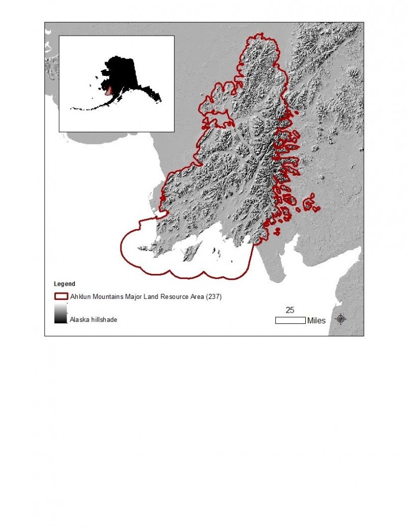
The Ahklun Mountains Major Land Resource Area (MLRA 237) is in western Alaska (fig. 3). This MLRA covers approximately 14,555 square miles, and it includes the mountains, hills, and valleys of the Kilbuck Mountains in the north and the Ahklun Mountains in the south. Except for the Kilbuck Mountains and the highest ridges of the Ahklun Mountains, the MLRA was extensively glaciated during the Pleistocene (Kautz et al., 2004). Today, a few small glaciers persist in mountainous cirques (Gallant et al., 1995). The present-day landscape and landforms reflect this glacial history; glacial moraines and glacial drift cover much of the area (USDA-NRCS, 2006). The landscape of the MLRA is primarily defined by low, steep, rugged mountains cut by narrow-to-broad valleys. Flood plains and terraces of varying sizes are common at the lower elevations in the valley bottoms. Glacially carved valleys host many lakes. Togiak Lake is one of the largest lakes in the region. It is 13 miles long and about 9,500 acres in size. Major rivers include the Goodnews, Togiak, Kanektok, Osviak, Eek, and Arolik Rivers. Where the Goodnews and Togiak Rivers reach the coast, the nearly level to rolling deltas support numerous small lakes.
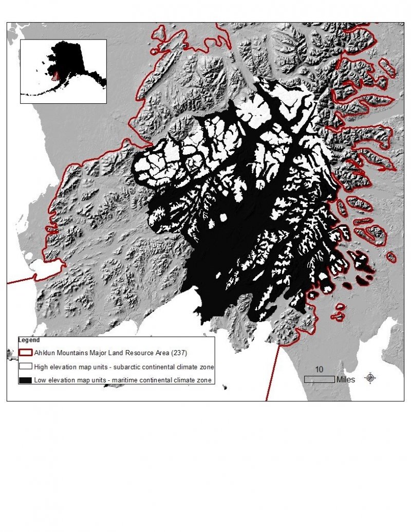
This MLRA has two distinct climatic zones: subarctic continental and maritime continental (fig. 4). The high-elevation areas are in the subarctic continental zone. The mean annual precipitation is more than 75 inches, and the mean annual air temperature is below about 27 degrees F (-3 degrees C) in extreme locations. The warmer, drier areas at the lower elevations are in the maritime continental zone. The mean annual precipitation is 20 to 50 inches, and the mean annual air temperature is about 30 to 32 degrees F (-0.2 to 1.2 degrees C) (PRISM). This climatic zone is influenced by both maritime and continental factors. The temperatures in summer are moderated by the open waters of the Bering Sea, and the temperatures in winter are more continental due to the presence of ice in the sea (Western Regional Climate Center, 2017). The seasonal ice reaches its southernmost extent off the coast of Alaska in Bristol Bay (Alaska Climate Research Center, 2017). The western coast of Alaska is also influenced by high winds from strong storms and airmasses in the Interior Region of Alaska (Hartmann, 2002).
The Ahklun Mountains MLRA is principally undeveloped wilderness. Federally managed lands include the Togiak and Alaska Maritime National Wildlife Refuges. The MLRA is sparsely populated, but it has several communities, including Togiak, Manokotak, Twin Hills, and Goodnews Bay. Togiak is the largest village. It has a population of approximately 855, most of which are Yup’ik Alaska Natives (U.S. Census Bureau, 2016). Major land uses include subsistence activities (fishing, hunting, and gathering) and wildlife recreation (USDA-NRCS, 2006; Kautz et al., 2004).
Ecological site concept
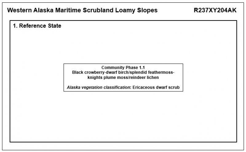
This ecological site is on mountain slopes, hillslopes, and glaciated plains throughout the Ahklun Mountains area. The slopes are linear to convex. The soils are well drained. The vegetation in community 1.1 stabilizes the soils, resulting in negligible downslope erosion. The reference state supports one documented community phase.
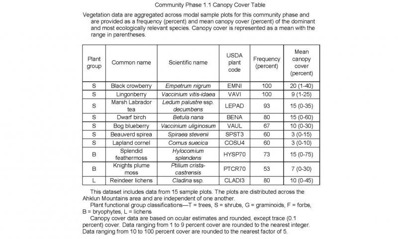
The reference plant community is a shrub tundra consisting of black crowberry (Empetrum nigrum), dwarf birch (Betula nana), marsh Labrador tea (Ledum palustre ssp. decumbens), lingonberry (Vaccinium vitis-idaea), and bog blueberry (Vaccinium uliginosum). Various lichens and mosses make up much of the ground cover.
Associated sites
| R237XY202AK |
Western Alaska Maritime Mosaic Gravelly Slopes Site R237XY204AK is on convex to linear slopes of mountains and hills and linear slopes of rolling, glaciated plains throughout the Ahklun Mountains area. Ecological sites R237XY202AK, R237XY210AK, R237XY211AK, R237XY212AK, R237XY222AK, R237XY230AK, and R237XY218AK are adjacent to or in close proximity to site R237XY204AK. These sites are differentiated by one or more criteria, including landform, landform position, associated soils, associated disturbance regimes, and the type and amount of plants. |
|---|---|
| R237XY210AK |
Western Alaska Maritime Scrubland Gravelly Flood Plains Site R237XY204AK is on convex to linear slopes of mountains and hills and linear slopes of rolling, glaciated plains throughout the Ahklun Mountains area. Ecological sites R237XY202AK, R237XY210AK, R237XY211AK, R237XY212AK, R237XY222AK, R237XY230AK, and R237XY218AK are adjacent to or in close proximity to site R237XY204AK. These sites are differentiated by one or more criteria, including landform, landform position, associated soils, associated disturbance regimes, and the type and amount of plants. |
| R237XY211AK |
Western Alaska Maritime Scrubland Loamy Flood Plains Site R237XY204AK is on convex to linear slopes of mountains and hills and linear slopes of rolling, glaciated plains throughout the Ahklun Mountains area. Ecological sites R237XY202AK, R237XY210AK, R237XY211AK, R237XY212AK, R237XY222AK, R237XY230AK, and R237XY218AK are adjacent to or in close proximity to site R237XY204AK. These sites are differentiated by one or more criteria, including landform, landform position, associated soils, associated disturbance regimes, and the type and amount of plants. |
| R237XY212AK |
Western Alaska Maritime Scrubland Silty Flood Plains Site R237XY204AK is on convex to linear slopes of mountains and hills and linear slopes of rolling, glaciated plains throughout the Ahklun Mountains area. Ecological sites R237XY202AK, R237XY210AK, R237XY211AK, R237XY212AK, R237XY222AK, R237XY230AK, and R237XY218AK are adjacent to or in close proximity to site R237XY204AK. These sites are differentiated by one or more criteria, including landform, landform position, associated soils, associated disturbance regimes, and the type and amount of plants. |
| R237XY222AK |
Western Alaska Maritime Scrubland Loamy Hummocks Site R237XY204AK is on convex to linear slopes of mountains and hills and linear slopes of rolling, glaciated plains throughout the Ahklun Mountains area. Ecological sites R237XY202AK, R237XY210AK, R237XY211AK, R237XY212AK, R237XY222AK, R237XY230AK, and R237XY218AK are adjacent to or in close proximity to site R237XY204AK. These sites are differentiated by one or more criteria, including landform, landform position, associated soils, associated disturbance regimes, and the type and amount of plants. |
| R237XY230AK |
Western Alaska Maritime Scrubland Silty Plains and Mountain Slopes, Lower Site R237XY204AK is on convex to linear slopes of mountains and hills and linear slopes of rolling, glaciated plains throughout the Ahklun Mountains area. Ecological sites R237XY202AK, R237XY210AK, R237XY211AK, R237XY212AK, R237XY222AK, R237XY230AK, and R237XY218AK are adjacent to or in close proximity to site R237XY204AK. These sites are differentiated by one or more criteria, including landform, landform position, associated soils, associated disturbance regimes, and the type and amount of plants. |
| R237XY218AK |
Western Alaska Maritime Dwarf Scrubland Gravelly Slopes, Concave Site R237XY204AK is on convex to linear slopes of mountains and hills and linear slopes of rolling, glaciated plains throughout the Ahklun Mountains area. Ecological sites R237XY202AK, R237XY210AK, R237XY211AK, R237XY212AK, R237XY222AK, R237XY230AK, and R237XY218AK are adjacent to or in close proximity to site R237XY204AK. These sites are differentiated by one or more criteria, including landform, landform position, associated soils, associated disturbance regimes, and the type and amount of plants. |
Similar sites
| R237XY201AK |
Western Alaska Maritime Scrubland Gravelly Slopes Site R237XY201AK supports some of the same low and dwarf shrub species as those supported by site R237XY204AK, but the overall reference plant communities differ. The total cover of shrubs and moss in site R237XY201AK is lower and the total cover of lichen is much higher and more diverse than in the reference plant community of site R237XY204AK. Site R237XY201AK is susceptible to caribou cratering and wind erosion, and site R237XY204AK is not. |
|---|---|
| R237XY215AK |
Western Alaska Maritime Scrubland Loamy Plains Although many of the same species are in the reference plant community of sites R237XY215AK and R237XY204AK, shrubs appear to be much less productive in site R237XY215AK (personal observation). Climatic factors and exposure likely cause this difference in production. |
| R237XY218AK |
Western Alaska Maritime Dwarf Scrubland Gravelly Slopes, Concave Site R237XY218AK supports a reference plant community similar to that of site R237XY204AK. Site R237XY218AK is at higher elevations, and alpine plants such as Alaska bellheather (Harrimanella stelleriana) and Aleutian mountainheath (Phyllodoce aleutica) are interspersed throughout the scrubland in this site. Site R237XY204AK does not support alpine plants. |
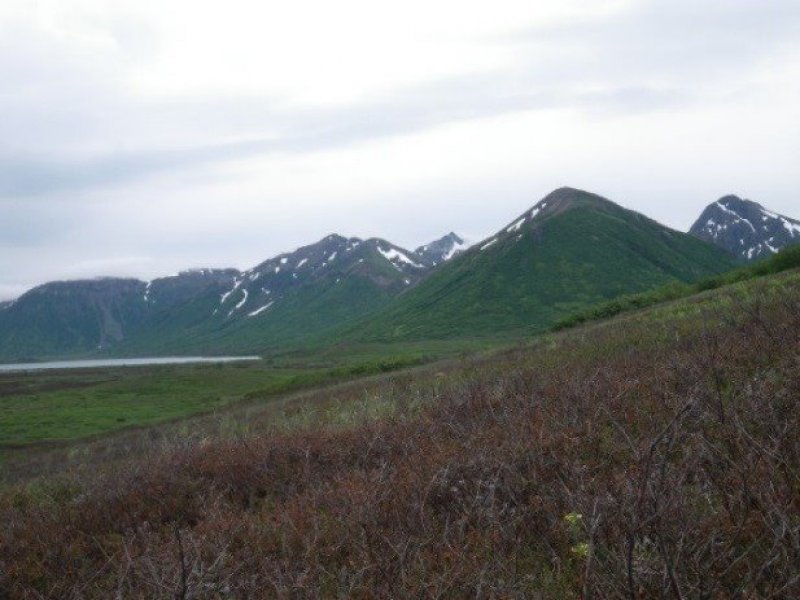
Figure 1. Site R237XY204AK is on linear to convex slopes of mountains and glaciated plains.
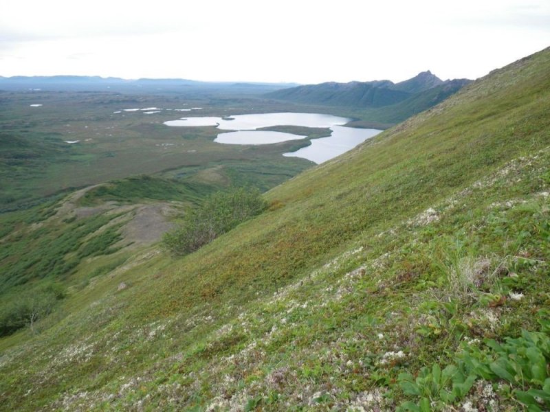
Figure 2. The Buchia soil is on mountain backslopes. Plant productivity may decrease as elevation increases.
Table 1. Dominant plant species
| Tree |
Not specified |
|---|---|
| Shrub |
(1) Empetrum nigrum |
| Herbaceous |
(1) Cladina |
Click on box and path labels to scroll to the respective text.
