Description
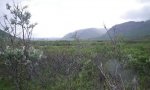
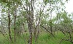
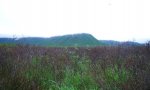
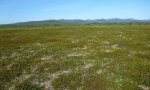
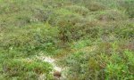
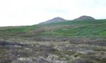
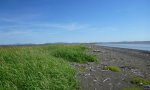
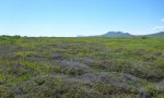
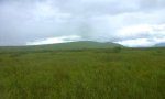
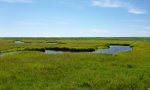
The Ahklun Mountains Major Land Resource Area (MLRA 237) is located in western Alaska (fig. 1). Covering approximately 14,555 square miles, this MLRA includes the mountains, hills, and valleys of the Kilbuck Mountains in the north and the Ahklun Mountains in the south. With the exception of the Kilbuck Mountains and the highest ridges of the Ahklun Mountains, this MLRA was extensively glaciated during the Pleistocene (Kautz et al., 2004). Today, a few small glaciers persist in mountainous cirques (Gallant et al., 1995). The present-day landscape and landforms reflect this glacial history, with glacial moraines and drift covering much of the area (USDA-NRCS, 2006). The MLRA landscape is primarily defined by low, steep rugged mountains cut by narrow-to-broad valleys. Flood plains and terraces of varying sizes are common at lower elevations in valley bottoms. Glacially carved valleys host many lakes. Togiak Lake is one of the largest lakes in the region, measuring 13 miles long and about 9,500 acres in size. Major rivers include the Goodnews, Togiak, Kanektok, Osviak, Eek, and Arolik. Where the Goodnews and Togiak rivers reach the coast, the nearly-level to rolling deltas support numerous small lakes. This MLRA has two distinct climatic zones: subarctic continental and maritime continental (fig. 2). High elevation areas are considered subarctic continental, which have annual precipitation over 75 inches and mean annual temperatures below -3°C in extreme locations. Warmer, dryer areas at lower elevations are maritime continental. Mean annual precipitation ranges from 20 to 50 inches and mean annual temperature ranges from -0.2°C to 1.2°C (PRISM). This climate zone is influenced by both maritime and continental factors. Summer temperatures are moderated by the open waters of the Bering Sea, while winter temperatures are more continental in nature due to the presence of sea ice (Western Regional Climate Center, 2017). Seasonal sea ice reaches its southernmost extent off the coast of Alaska in Bristol Bay (Alaska Climate Research Center, 2017). The western Alaskan coast is also influenced by high winds from strong storms and from air masses in the Interior region (Hartmann, 2002). The Ahklun Mountains MLRA is principally undeveloped wilderness. Federally managed lands include the Togiak and Alaska Maritime National Wildlife Refuges. While sparsely populated, this area contains several communities, including Togiak, Manokotak, Twin Hills and Goodnews Bay. The largest village is Togiak, with a population of approximately 855 predominantly Yup’ik Alaska Natives (U.S. Census Bureau, 2016). Major land uses include subsistence activities (fishing, hunting, and gathering) and wildlife recreation (USDA-NRCS, 2006; Kautz et al., 2004).
Key publications
Next steps
-
1
Select an ecological site
Select an ecological site using the list, keys, photos, briefcase, or quick search option located on this page. -
2
Explore the ecological site description
Next, learn more about the selected ecological site and its characteristic dynamics by browsing the ecological site description and exploring alternative state and transition model formats.
Ecological site list
-
i
Key Characteristics
- Vegetated Areas - supports an ecological site
- Western Maritime, Low Elevation
- Lowlands
- Floodplains
- Mid to High Floodplain along Izaveiknik River - occasional to rare flooding
- Western Alaska Maritime Climate Zone
- Low Elevation
- Lowlands
- Flood Plains and Coastal Plains
- Flood Plains & Terraces
- Flood Plains &Terraces - linear slopes
- Flood Plain
- Flood Plain along Izaveiknik River - mid to high floodplain
-
i
Key Characteristics
- Vegetated Areas - supports an ecological site
- Western Maritime, Low Elevation
- Uplands
- Mountains & Hills
- Footslopes & Toeslopes
- Convex to Concave Slopes, not a swale
- Proximal to northern three-quarters of Togiak Lake
- Western Alaska Maritime Climate Zone
- Low Elevation
- Uplands
- Mountains and Hills
- Mountain and Hill Slopes
- Other
- Footslopes, toeslopes, lower backslopes and mountain bases
- Other
- Well to excessively well drained soil (convex to concave slopes)
- Proximal to northern three-quarters of Togiak Lake
- Western Alaska Maritime Climate Zone
- Low Elevation
- Uplands
- Mountains and Hills
- Other Mountain and Hill Landforms
- Alluvial fans
- Shallow to root restrictive layer
-
i
Key Characteristics
- Vegetated Areas - supports an ecological site
- Western Maritime, Low Elevation
- Lowlands
- Discharge Slopes, Fans, Seeps on Mountains
- Western Alaska Maritime Climate Zone
- Low Elevation
- Uplands
- Mountains and Hills
- Other Mountain and Hill Landforms
- Alluvial fans
- Very deep to root restrictive layer
- Western Alaska Maritime Climate Zone
- Low Elevation
- Lowlands
- Other Landforms
- Discharge Slopes & Seeps on Mountains
-
i
Key Characteristics
- Boreal Climate Zone
- Rounded Mountains - subalpine, linear to concave, backslopes to footslopes
-
 ProvisionalF237XY261AK/F237XY261AKBoreal Forest Mountain Backslopes and Footslopes, Linear to Convexi
Key Characteristics
- Boreal Climate Zone
- Rugged Mountains
- Other
- Backslopes and Footslopes
- Linear to Convex slopes
-
ProvisionalF237XY262AK/F237XY262AKBoreal Forest Mountain Backslopes and Footslopes, Linear to Concavei
Key Characteristics
- Boreal Climate Zone
- Rugged Mountains
- Other
- Backslopes and Footslopes
- Linear to Concave slopes
-
i
Key Characteristics
- Boreal Climate Zone
- Rugged Mountains
- Other
- Drainageways
-
i
Key Characteristics
- Boreal Climate Zone
- Rugged Mountains
- Alpine and Subalpine
- Subalpine - linear to concave backslopes and footslopes
-
i
Key Characteristics
- Vegetated Areas - supports an ecological site
- Western Maritime, Low Elevation
- Uplands
- Plains and Terraces
- Undulating and Rolling Landforms
- Convex Positions & High Linear positions shallow to sandy-skeletal material (well drained soil)
- Western Alaska Maritime Climate Zone
- Low Elevation
- Uplands
- Plains
- Other Landforms
- Non-Linear Landforms
- Other Landforms
- Convex and linear upper slope positions; well drained soil
-
i
Key Characteristics
- Vegetated Areas - supports an ecological site
- Western Maritime, Low Elevation
- Uplands
- Mountains & Hills
- Backslopes
- Linear to concave, center and upper third slopes
- Western Alaska Maritime Climate Zone
- Low Elevation
- Uplands
- Mountains and Hills
- Mountain and Hill Slopes
- Other
- Backslopes, shoulders & center to upper third mountain flanks
- Slopes without earth hummocks
- Concave to linear slope shape (Colluvial backslopes)
- Western Alaska Maritime Climate Zone
- Low Elevation
- Uplands
- Mountains and Hills
- Mountain and Hill Slopes
- Other
- Footslopes, toeslopes, lower backslopes and mountain bases
- Other
- Well to excessively well drained soil (convex to concave slopes)
- Not proximal to northern three-quarters of Togiak Lake
- Linear to concave slopes
-
i
Key Characteristics
- Vegetated Areas - supports an ecological site
- Western Maritime, Low Elevation
- Lowlands
- Drainageways - steep escarpments; gravelly, well-drained soils
- Western Alaska Maritime Climate Zone
- Low Elevation
- Lowlands
- Other Landforms
- Drainageways - steep escarpments, gravelly, well drained soil
-
i
Key Characteristics
- Vegetated Areas - supports an ecological site
- Western Maritime, Low Elevation
- Uplands
- Plains and Terraces
- Undulating and Rolling Landforms
- Linear positions (well-drained soils), short slope length
- Western Alaska Maritime Climate Zone
- Low Elevation
- Uplands
- Plains
- Other Landforms
- Linear Landforms
- No earth hummocks present
- Undulating drift plains - short slope lengths, well drained soil
- Western Alaska Maritime Climate Zone
- Low Elevation
- Uplands
- Mountains and Hills
- Mountain and Hill Slopes
- Other
- Backslopes, shoulders & center to upper third mountain flanks
- Slopes without earth hummocks
- Convex to linear slope shape (more stable slope position)
- Western Alaska Maritime Climate Zone
- Low Elevation
- Uplands
- Mountains and Hills
- Mountain and Hill Slopes
- Other
- Footslopes, toeslopes, lower backslopes and mountain bases
- Other
- Well to excessively well drained soil (convex to concave slopes)
- Not proximal to northern three-quarters of Togiak Lake
- Linear to convex sites
-
i
Key Characteristics
- Vegetated Areas - supports an ecological site
- Western Maritime, High Elevation (Uplands, Mountains)
- Swales - upper third of mountain slopes (alpine), slope alluvium
- Western Alaska Maritime Climate Zone
- High Elevation (Uplands & Mountains)
- Concave Microfeatures on Mountain Slopes
- Swales - upper third of mountain slopes (alpine), slope alluvium
- Western Alaska Maritime Climate Zone
- Low Elevation
- Uplands
- Plains
- Other Landforms
- Non-Linear Landforms
- Other Landforms
- Concave to linear slopes, including swales
- Western Alaska Maritime Climate Zone
- Low Elevation
- Uplands
- Mountains and Hills
- Mountain and Hill Slopes
- Other
- Footslopes, toeslopes, lower backslopes and mountain bases
- Swales
-
 ProvisionalR237XY206AK/R237XY206AKWestern Alaska Maritime Dwarf Scrubland Loamy Drainage, High Elevationi
Key Characteristics
- Vegetated Areas - supports an ecological site
- Western Maritime, High Elevation (Uplands, Mountains)
- Drainageways - upper third of mountain slopes (alpine), slope alluvium, gravelly soil
- Western Alaska Maritime Climate Zone
- High Elevation (Uplands & Mountains)
- Concave Microfeatures on Mountain Slopes
- Drainageways - upper third of mountain slopes, slope alluvium and gravelly soil
-
i
Key Characteristics
- Vegetated Areas - supports an ecological site
- Western Maritime, Low Elevation
- Uplands
- Plains and Terraces
- Depressions
- Western Alaska Maritime Climate Zone
- Low Elevation
- Uplands
- Plains
- Depressions
- Western Alaska Maritime Climate Zone
- Low Elevation
- Lowlands
- Flood Plains and Coastal Plains
- Flood Plains & Terraces
- Microfeatures on Flood Plains & Terraces - concave
- Depressions on Flood Plains
- Scrub wetland, very poorly drained
- Western Alaska Maritime Climate Zone
- Low Elevation
- Lowlands
- Flood Plains and Coastal Plains
- Coastal Plains
- Shore Complex
- Other (not a rise)
- Depression
-
i
Key Characteristics
- Vegetated Areas - supports an ecological site
- Western Maritime, Low Elevation
- Lowlands
- Floodplains
- Low Floodplain - frequent flooding, often confined by escarpments
- Western Alaska Maritime Climate Zone
- Low Elevation
- Lowlands
- Flood Plains and Coastal Plains
- Flood Plains & Terraces
- Flood Plains &Terraces - linear slopes
- Flood Plain
- Other Flood Plains
- Low Flood Plains
- Proximal to river system, frequent flooding
-
i
Key Characteristics
- Vegetated Areas - supports an ecological site
- Western Maritime, Low Elevation
- Lowlands
- Floodplains
- Mid Floodplain - occasional flooding, moderately well to well drained
- Western Alaska Maritime Climate Zone
- Low Elevation
- Lowlands
- Flood Plains and Coastal Plains
- Flood Plains & Terraces
- Flood Plains &Terraces - linear slopes
- Flood Plain
- Other Flood Plains
- Mid Flood Plains
- Moderately well to well drained soil
-
i
Key Characteristics
- Vegetated Areas - supports an ecological site
- Western Maritime, Low Elevation
- Lowlands
- Floodplains
- Mid Floodplain - occasional flooding, somewhat poorly to poorly drained
- Western Alaska Maritime Climate Zone
- Low Elevation
- Lowlands
- Flood Plains and Coastal Plains
- Flood Plains & Terraces
- Flood Plains &Terraces - linear slopes
- Flood Plain
- Other Flood Plains
- Mid Flood Plains
- Somewhat poorly to poorly drained soil
- Western Alaska Maritime Climate Zone
- Low Elevation
- Lowlands
- Flood Plains and Coastal Plains
- Flood Plains & Terraces
- Flood Plains &Terraces - linear slopes
- Terrace
- Hummocks absent
-
i
Key Characteristics
- Vegetated Areas - supports an ecological site
- Western Maritime, Low Elevation
- Uplands
- Plains and Terraces
- Outwash Plains (slightly convex)
- Western Alaska Maritime Climate Zone
- Low Elevation
- Uplands
- Plains
- Other Landforms
- Non-Linear Landforms
- Outwash Plains
-
 ProvisionalR237XY217AK/R237XY217AKWestern Alaska Maritime Dwarf Scrubland Gravelly Slopes, High Elevationi
Key Characteristics
- Vegetated Areas - supports an ecological site
- Western Maritime, High Elevation (Uplands, Mountains)
- Summits, Shoulders, Upper Mtn Backslopes
- Summits & Shoulders - shallow to lithic contact, no glacial parent material
- Western Alaska Maritime Climate Zone
- High Elevation (Uplands & Mountains)
- Summits, Shoulders and Mountain Slopes
- Summits and Shoulders
- Permafrost absent
-
 ProvisionalR237XY218AK/R237XY218AKWestern Alaska Maritime Dwarf Scrubland Gravelly Slopes, Concavei
Key Characteristics
- Vegetated Areas - supports an ecological site
- Western Maritime, High Elevation (Uplands, Mountains)
- Backslopes & Footslopes - concave upper backslopes and footslopes on upper third of mountains
- Western Alaska Maritime Climate Zone
- High Elevation (Uplands & Mountains)
- Summits, Shoulders and Mountain Slopes
- Mountain Slopes
- Concave to linear slopes; mountain flanks and mountain bases
-
 ProvisionalR237XY219AK/R237XY219AKWestern Alaska Maritime Dwarf Scrubland Gravelly Slopes, Very Steepi
Key Characteristics
- Vegetated Areas - supports an ecological site
- Western Maritime, High Elevation (Uplands, Mountains)
- Summits, Shoulders, Upper Mtn Backslopes
- Very Steep Backslopes - high elevation, very gravelly
- Western Alaska Maritime Climate Zone
- High Elevation (Uplands & Mountains)
- Summits, Shoulders and Mountain Slopes
- Mountain Slopes
- Convex to linear slopes - very steep, very gravelly soil
-
i
Key Characteristics
- Vegetated Areas - supports an ecological site
- Western Maritime, Low Elevation
- Uplands
- Plains and Terraces
- Linear Landforms
- Earth hummocks present
- Mosaic hummocks (microtopography creates unique veg communities on tops and bottoms of hummocks)
- Western Alaska Maritime Climate Zone
- Low Elevation
- Uplands
- Plains
- Other Landforms
- Linear Landforms
- Earth hummocks present
- Mosaic hummocks
-
i
Key Characteristics
- Vegetated Areas - supports an ecological site
- Western Maritime, Low Elevation
- Uplands
- Plains and Terraces
- Linear Landforms
- Earth hummocks present
- Non-mosaic hummocks
- Western Alaska Maritime Climate Zone
- Low Elevation
- Uplands
- Plains
- Other Landforms
- Linear Landforms
- Earth hummocks present
- Non-mosaic hummocks
-
i
Key Characteristics
- Vegetated Areas - supports an ecological site
- Western Maritime, Low Elevation
- Lowlands
- Shore Complexes
- Rises
- Windward side of berm, proximal to bay
- Western Alaska Maritime Climate Zone
- Low Elevation
- Lowlands
- Flood Plains and Coastal Plains
- Coastal Plains
- Shore Complex
- Berms
- Windward side of berm, proximal to bay
-
i
Key Characteristics
- Vegetated Areas - supports an ecological site
- Western Maritime, Low Elevation
- Lowlands
- Shore Complexes
- Rises
- Leeward side of berm, set back from bay
- Western Alaska Maritime Climate Zone
- Low Elevation
- Lowlands
- Flood Plains and Coastal Plains
- Coastal Plains
- Shore Complex
- Berms
- Leeward side of berm, distal from bay
-
i
Key Characteristics
- Vegetated Areas - supports an ecological site
- Western Maritime, Low Elevation
- Lowlands
- Floodplains
- Depressions on Floodplain
- Mineral depression
- Western Alaska Maritime Climate Zone
- Low Elevation
- Lowlands
- Flood Plains and Coastal Plains
- Flood Plains & Terraces
- Microfeatures on Flood Plains & Terraces - concave
- Depressions on Flood Plains
- Herbaceous wetland (grassland) - permanent water table, very long ponding
-
 ProvisionalR237XY230AK/R237XY230AKWestern Alaska Maritime Scrubland Silty Plains and Mountain Slopes, Loweri
Key Characteristics
- Vegetated Areas - supports an ecological site
- Western Maritime, Low Elevation
- Uplands
- Mountains & Hills
- Footslopes & Toeslopes
- Linear to Concave slopes
- Western Alaska Maritime Climate Zone
- Low Elevation
- Uplands
- Plains
- Other Landforms
- Linear Landforms
- No earth hummocks present
- Talf
- Western Alaska Maritime Climate Zone
- Low Elevation
- Uplands
- Mountains and Hills
- Mountain and Hill Slopes
- Other
- Footslopes, toeslopes, lower backslopes and mountain bases
- Other
- Moderately well drained soil (linear to concave slopes)
-
i
Key Characteristics
- Vegetated Areas - supports an ecological site
- Western Maritime, Low Elevation
- Lowlands
- Shore Complexes
- Talf
- Western Alaska Maritime Climate Zone
- Low Elevation
- Lowlands
- Flood Plains and Coastal Plains
- Coastal Plains
- Shore Complex
- Other (not a rise)
- Talf
-
i
Key Characteristics
- Western Alaska Maritime Climate Zone
- High Elevation (Uplands & Mountains)
- Summits, Shoulders and Mountain Slopes
- Summits and Shoulders
- Permafrost present - unsorted circles possible
-
i
Key Characteristics
- Western Alaska Maritime Climate Zone
- Low Elevation
- Lowlands
- Flood Plains and Coastal Plains
- Coastal Plains
- Not a Shore Complex
- Tidal Flats
-
ProvisionalR237XY255AK/R237XY255AKWestern Alaska Maritime Tall Scrubland Mountain and Hill Drainagewaysi
Key Characteristics
- Western Alaska Maritime Climate Zone
- Low Elevation
- Uplands
- Mountains and Hills
- Mountain and Hill Slopes
- Drainageway
-
ProvisionalR237XY256AK/R237XY256AKWestern Alaska Maritime Tussock-Scrub Mountain Slopes, Hummockedi
Key Characteristics
- Western Alaska Maritime Climate Zone
- Low Elevation
- Uplands
- Mountains and Hills
- Mountain and Hill Slopes
- Other
- Backslopes, shoulders & center to upper third mountain flanks
- Slopes with earth hummocks
- Western Alaska Maritime Climate Zone
- Low Elevation
- Uplands
- Mountains and Hills
- Other Mountain and Hill Landforms
- Saddles - earth hummocks present
-
i
Key Characteristics
- Western Alaska Maritime Climate Zone
- Low Elevation
- Lowlands
- Flood Plains and Coastal Plains
- Flood Plains & Terraces
- Flood Plains &Terraces - linear slopes
- Terrace
- Hummocks present
-
i
Key Characteristics
- Western Alaska Maritime Climate Zone
- Low Elevation
- Lowlands
- Flood Plains and Coastal Plains
- Flood Plains & Terraces
- Microfeatures on Flood Plains & Terraces - concave
- Oxbow Lake
-
i
Key Characteristics
- Boreal Climate Zone
- Rugged Mountains
- Alpine and Subalpine
- Alpine
- Summits and Shoulders - Linear
-
i
Key Characteristics
- Western Alaska Maritime Climate Zone
- Low Elevation
- Lowlands
- Flood Plains and Coastal Plains
- Coastal Plains
- Not a Shore Complex
- Flood Plain
-
ProvisionalR237XY268AK/R237XY268AKWestern Alaska Maritime Scrubland on Low Flood Plains, distal from riveri
Key Characteristics
- Western Alaska Maritime Climate Zone
- Low Elevation
- Lowlands
- Flood Plains and Coastal Plains
- Flood Plains & Terraces
- Flood Plains &Terraces - linear slopes
- Flood Plain
- Other Flood Plains
- Low Flood Plains
- Distal from river system, less than frequent flooding
-
ProvisionalR237XY270AK/R237XY270AKBoreal Alpine Dwarf Scrub Mountain Summits and Shoulders, Convexi
Key Characteristics
- Boreal Climate Zone
- Rugged Mountains
- Alpine and Subalpine
- Alpine
- Summits and Shoulders - Convex

Ecological site map
Basemap
Find me
Find point
Full screen
Zoom in to display soil survey map units for an area of interest, and zoom out to display MLRAs. Select a map unit polygon to view ecological sites correlated to that map unit. View a brief description of an ecological site by clicking on its name in the map popup. Soil survey correlations may not be accurate, and ecological site classification of a location should always be verified in the field. Each selection may require the transfer of several hundred KB of data.
Ecological site keys
Ecological site photos
Print Options
Sections
Font
Other
Briefcase
Add ecological sites and Major Land Resource Areas to your briefcase by clicking on the briefcase (![]() ) icon wherever it occurs. Drag and drop items to reorder. Cookies are used to store briefcase items between browsing sessions. Because of this, the number of items that can be added to your briefcase is limited, and briefcase items added on one device and browser cannot be accessed from another device or browser. Users who do not wish to place cookies on their devices should not use the briefcase tool. Briefcase cookies serve no other purpose than described here and are deleted whenever browsing history is cleared.
) icon wherever it occurs. Drag and drop items to reorder. Cookies are used to store briefcase items between browsing sessions. Because of this, the number of items that can be added to your briefcase is limited, and briefcase items added on one device and browser cannot be accessed from another device or browser. Users who do not wish to place cookies on their devices should not use the briefcase tool. Briefcase cookies serve no other purpose than described here and are deleted whenever browsing history is cleared.
Ecological sites
Major Land Resource Areas
The Ecosystem Dynamics Interpretive Tool is an information system framework developed by the USDA-ARS Jornada Experimental Range, USDA Natural Resources Conservation Service, and New Mexico State University.