Ecological site group R017XY904CAESG
Subirrigated Deep Alluvial Fans
Last updated: 06/03/2024
Accessed: 02/21/2026
Ecological site group description
Key Characteristics
- Landform Not As Above
- Not As Above
- Site is Sub-Irrigated
- Flooding is Rare
Provisional. A provisional ecological site description has undergone quality control and quality assurance review. It contains a working state and transition model and enough information to identify the ecological site.
Physiography
This group is found on the large alluvial fans and terraces on both the east and west sides of the Sacramento Valley and the east side of the San Joaquin Valley.
Climate
The average annual precipitation is 5 to 12 inches (125 to 305 millimeters) in the San Joaquin Valley. The Tulare Basin, at the southern end of this MLRA, typically receives less than 6 inches (150 millimeters) of rainfall per year. The average annual precipitation is 12 to 30 inches (305 to 760 millimeters) in most of the Sacramento Valley. It is 40 inches (1,015 millimeters) at the higher elevations on the edges of the valley at the north end. Summers are long, hot, and dry, and winters are cool and rainy. Most of the rainfall occurs as low- or moderate intensity, Pacific frontal storms from October to May. Snow is very rare in this MLRA but has occurred in the Sacramento Valley from Sacramento to points farther north. The average annual temperature is 59 to 67 degrees F (15 to 20 degrees C), decreasing from south to north. The freeze-free period averages 325 days and ranges from 280 to 365 days, decreasing in length with elevation and from south to north.
Soil features
These soils are greater that two meters deep and and have a variety of textures. Soil series supporting this site historically include Vina, Grangeville, and Liveoak
Vegetation dynamics
Deep soils of the floodplains and fan terraces of MLRA 17, such as the Grangeville, Liveoak and Fiddyment soil series, historically supported valley oak (Quercus lobata) woodlands which extended up to four miles from the principal stream channel (Barbour et al., 2007).
Valley Oak are among the largest and longest living hardwood trees in the western United States. They form both dense woodlands and open savanna depending on site specific factors relating to plant available water. Being winter deciduous in a Mediterranean climate the trees are under considerable water stress in the summer and so they must have access to a permanent water table. Mature oaks have a tap root that may extend up to 20 meters to access summer water (Lewis and Burghy, 1964). The mature oaks pump water towards the surface and it becomes available to other plants (Querejeta et al., 2014) including oak saplings.
Native peoples routinely burned valley oak woodlands to manage understory vegetation (Anderson, 2005), which removed understory vegetation and favored oak recruitment (FEIS). Fire is likely to top-kill seedlings, saplings and old hollow trees (Griffin, 1977). Post fire, saplings frequently resprout from established roots and acorns cached below ground by birds and small mammals were well positioned to germinate and thrive (FEIS). The historic fire regime played an important role in the historic structure of this community, and it is believed that modern fire suppression is one cause of diminished oak recruitment (NatureServe).
The impacts of livestock grazing have also been studied and generally contribute to an open structure similar to frequent fire (WHR). Though, other sources have found that grazing can reduce oak recruitment, currently there is contradictory evidence on the over all impact of grazing in oak woodland (Tyler, et al 2006).
The historical area and distribution of these site is poorly understood because of they way they intergrade with other sites and limitations of historic mapping methods (Bloom and Bahre, 2005). The Central Valley Historic Mapping Project reports 1.2 million acres historically with about 73% remaining at present.
References/Citations:
Anderson, K. 2013. Tending the wild: Native American knowledge and the management of California's natural resources. Berkeley, California, University of California Press.
Barbour, M., Keeler-Wolf, T., & Schoenherr, A. A. (Eds.). 2007. Terrestrial vegetation of California. Univ of California Press.
Bloom, K. J., & Bahre, C. J. 2005. Aboriginal distribution of Quercus lobata woodland on the Kaweah River Delta, California. Madroño, 52(1), 72-73.
Howard, Janet L. 1992. Quercus lobata. In: Fire Effects Information System, [Online]. U.S. Department of Agriculture, Forest Service, Rocky Mountain Research Station, Fire Sciences Laboratory (Producer). Available: https://www.fs.usda.gov/database/feis/plants/tree/quelob/all.html [2023, December 12].
Lewis, D. C., & Burgy, R. H. 1964. The relationship between oak tree roots and groundwater in fractured rock as determined by tritium tracing. Journal of Geophysical Research, 69(12), 2579-2588.
Ritter, Lyman V. 2005. California Wildlife Habitat Relationships: Accessed: https://nrm.dfg.ca.gov/FileHandler.ashx?DocumentID=67342&inline [2023, December 12].
Querejeta, J. I., Egerton-Warburton, L. M., & Allen, M. F. 2007. Hydraulic lift may buffer rhizosphere hyphae against the negative effects of severe soil drying in a California Oak savanna. Soil biology and Biochemistry, 39(2), 409-417.
Tyler, C. M., Kuhn, B., & Davis, F. W. 2006. Demography and recruitment limitations of three oak species in California. The quarterly review of biology, 81(2), 127-152.
Major Land Resource Area
MLRA 017X
Sacramento and San Joaquin Valleys
Stage
Provisional
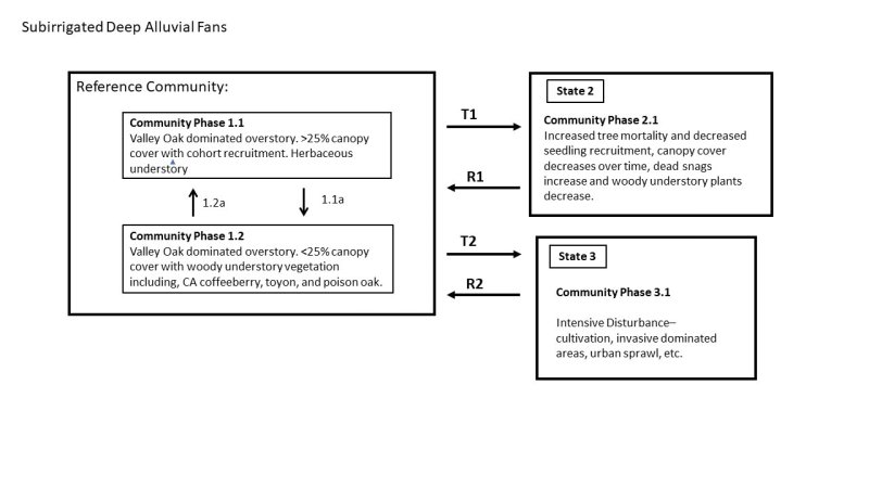
Click on box and path labels to scroll to the respective text.
Ecosystem states
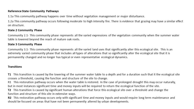
| T1 | - | Lowering Water Table |
|---|---|---|
| T2 | - | Urbanization/ Agricultural Conversion |
| R1 | - | Hydrologic Restoration |
| T2 | - | Urbanization/ Agricultural Conversion |
| R2 | - | Extensive Restoration |
State 1 submodel, plant communities
| 1.1a | - | Community Succession |
|---|---|---|
| 1.2a | - | Fire |

