Ecological site group F019XG915CA
Sandy Hills <30"ppt
Last updated: 07/06/2023
Accessed: 02/21/2026
Ecological site group description
Key Characteristics
- located on hills
- sandy texture
- <30" ppt
Provisional. A provisional ecological site description has undergone quality control and quality assurance review. It contains a working state and transition model and enough information to identify the ecological site.
Physiography
This ESG is found typically on sloping to steeply sloping (15-50% most typical) mountains from 5,000-7,300 feet.
Climate
Mediterranean climate. It is also tolerant of frost, and high temperatures. However, its resistance to freezing is low relative to conifers that grow at higher elevations. Frost-free days are typically from 120 to 175 days.
Soil features
Ponderosa pine grows in many different soil types, in soils derived from igneous, metamorphic, and sedimentary substrates. It also grows in gabbro and other ultramafic soils. It grows in soils of many textural classes—but grows best in coarse-textured loams and moderately sandy or gravelly soils. Soil pH in ponderosa pine stands varies but usually ranging from slightly acidic to neutral (pH 6.0-7.0) in upper soil horizons.
Representative soils for this ESG are the Wapi and Pacifico family soils, which are typic or lithic Xeropsamments.
Vegetation dynamics
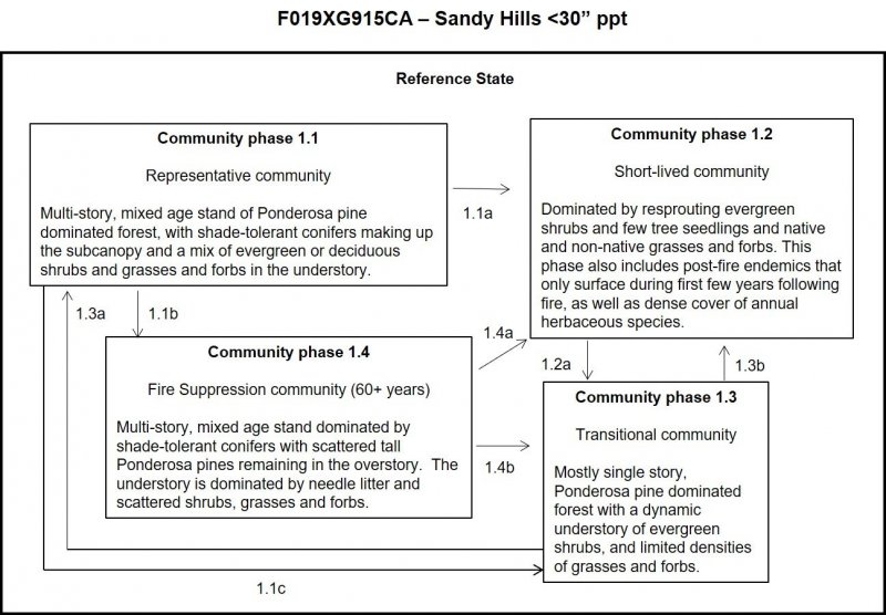
The ponderosa pine habitat includes pure stands of ponderosa pine as well as stands of mixed species in which at least 50% of the canopy area is Ponderosa pine. Associated species vary depending on location in the state and site conditions. Typical tree associates include white fir, incense-cedar, Coulter pine, Jeffrey pine, sugar pine, Douglas-fir, bigcone Douglas-fir, canyon live oak, California black oak, Oregon white oak, Pacific madrone and tanoak. Tree spacing in ponderosa pine stands varies from open patchy to extremely close. Typical overstory coverage of all layers may exceed 100%. Other conifers, when present, provide denser crowns than do the pine, thus creating habitat diversity. Grasses, shrubs, and deciduous trees may be present or absent. Typical coverage of shrubs is 10-30% and of grasses and forbs is 5-10%.
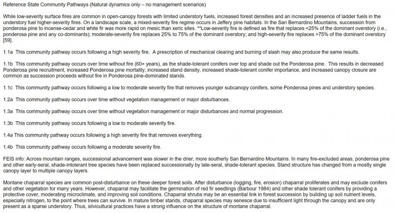
Ponderosa pine is shade intolerant. It is a successionally stable or climax species on low elevation, dry sites and seral on more mesic and mid elevation sites. At mid elevations, ponderosa pine is generally seral to Douglas-fir and other more mesophytic, shade-tolerant species. It is a minor late successional species in some poor-site (pumice) lodgepole pine stands of south-central Oregon. In southern Oregon and California, it is a late-successional species that displaces shrubs in montane chaparral. Ponderosa pine encroaches into some perennial grasslands and mountain meadows. It establishes in canopy gaps or larger openings resulting from fire, bark beetle outbreaks, or other disturbances. Low- to moderate-severity fire maintains ponderosa pine dominance. After stand replacing fire, succession in dry forest cover types generally follows a trajectory leading from dominance by annual herbs to dominance by conifers. Ponderosa pine is replaced successionally by shade-tolerant species with long fire-free periods, and is in decline as a forest cover type on fire excluded sites.
Frequent, low- and moderate-severity fires favor ponderosa pine and other shade-intolerant species. Understory vegetation is top-killed or killed without much mortality of the overstory, although patches of severe fire kill the overstory and create openings that favor ponderosa pine establishment. If fire-free intervals are long, shade-tolerant, understory Douglas-fir, grand fir, incense-cedar, and/or white fir increase in number and size, shading out ponderosa pine. Historically, long fire-free intervals on some sites, particularly north-facing slopes, allowed more fire sensitive species such as Douglas-fir to develop thicker bark before the next fire, so some shade-tolerant trees survived successive fires.
Information from:
California Wildlife Habitat Relationships System
California Department of Fish and Game
California Interagency Wildlife Task Group
E. Lee Fitzhugh
Major Land Resource Area
MLRA 019X
Southern California Coastal Plains and Mountains
Subclasses
- F019XG915CA–Sandy Hills <30"ppt
- F019XI200CA–Pinus muricata/Quercus pacifica 13-24" p.z.
- F019XI201CA–Pinus torreyana var. insularis/Nassella pulchra 21-31" p.z.
- R019XD033CA–LOAMY UPLANDS
- R019XD035CA–SANDY
- R019XD036CA–SHALLOW LOAMY UPLANDS
- R019XD060CA–SHALLOW LOAMY
- R019XD062CA–ACID CLAYPAN
- R019XE003CA–COARSE LOAMY
- R019XI100CA–Loamy slopes 13-31" p.z.
- R019XI102CA–Shallow uplands 13-24" p.z.
- R019XI105CA–Deep slopes 13-24" p.z.
- R019XI106CA–Shallow slopes 13-31" p.z.
- R019XI108CA–Convex slopes 13-24" p.z.
- R019XI110CA–Concave slopes 13-24" p.z.
- R019XI112CA–Moderately deep volcanic slopes 13-31" p.z.
- R019XI113CA–Loamy volcanic slopes 13-24" p.z.
- R019XI116CA–Clayey slopes 13-31" p.z.
- R019XI119CA–Gentle calcareous slopes 21-34" p.z.
- R019XI121CA–Rocky bluffs 24-34" p.z.
Correlated Map Unit Components
23481894, 23481900, 23481906, 23481910, 23481913, 23481921, 23481926, 23481929, 23482299, 23482301, 22642310, 22642344, 22642234, 22642235, 23477705, 23477701, 23477429, 22668425, 22668434, 22668762, 22668760, 22668194, 22668827, 22668272, 22668823, 22668821, 22668266, 22668545, 22668543, 22668529, 22668217, 22668218, 22669064, 22668278, 22668734, 22668800, 22668799, 22668863, 22668740, 22668198, 22668745, 22668758, 22668729, 22668730, 22668454, 22668459, 22668751, 22669004, 22668478, 22668213, 22669086, 22668486, 22668773, 22669054, 22588413, 22673489, 22673359, 22673753, 22673752, 22673516, 22673515, 22673630, 22673632, 22673634, 22673636, 22673638, 22673637, 22673518, 22673517, 22673404, 22673406, 22673524, 22673526, 22673759, 22673758, 22673646, 22673764, 22673408, 22673415, 22673769, 22673499, 22673602
Stage
Provisional
Contributors
Curtis Talbot
Click on box and path labels to scroll to the respective text.

