
Ecological site group EX043AESG12
Mesic, Xeric, Unglaciated, Loamy Hills and Canyons Ponderosa Pine/Shrub
Last updated: 05/02/2025
Accessed: 04/03/2026
Ecological site group description
Key Characteristics
None specified
Provisional. A provisional ecological site description has undergone quality control and quality assurance review. It contains a working state and transition model and enough information to identify the ecological site.
Physiography
Major Land Resource Area: 43A Northern Rocky Mountains
Modal LRU – 43A09 - Western Bitterroot Foothills
This LRU is composed predominantly of mid elevation slopes of foothills, low mountains and valley walls. The soils are dominantly andisols but also include loamy mollisols, and alfisols with mixed or thin ash surfaces. Parent materials are diverse with metasedimentary, metamorphic and granitic geology dominating. Areas of both recent and Tertiary age alluvium are also present. Soil climate is a mesic or frigid temperature regime and xeric or udic moisture regime with average annual precipitation around 895 mm (35 inches).
Others where occurring – 43A07 - Eastern Columbia Plateau Embayments
43A08 - Clearwater Canyons
Ecological Site Concept:
The data below describes the physiographic, climatic and other parameters for the ponderosa pine/shrub ES group as a whole. This vegetation alliance is widespread so a central tendency for each parameter is also described. See Appendix A for a finer division of the alliance based on selected soil features.
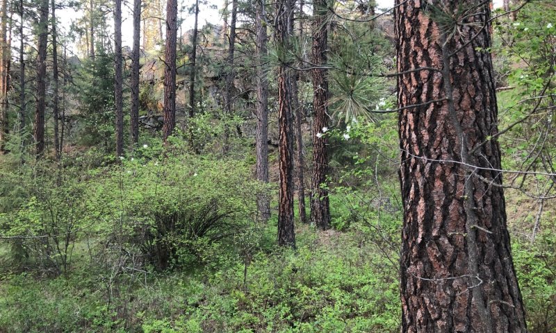
This ESD in distinguished by an overstory of ponderosa pine understory shrub component of ninebark, oceanspray, and snowberry. It occurs on foothills, mountainsides, and valet walls. This ESD fits into the National Vegetation Standard’s Central Rocky Mt. Pinus ponderosa / Shrub Understory alliance.
Physiographic Features
This ecological site group occurs mainly on low to mid elevation slopes of unglaciated foothills, mountainsides and valley walls. It is found predominantly on side slopes, foot slope, and flats. The parent material is loess or mixed volcanic ash and loess over residuum and colluvium from mainly granitic, metamorphic or metasedimentary rock.
Landscapes: Mountains, Canyonlands, Plateaus
Landform: Hill slopes, Structural Benches, Escarpments
Elevation:
Total range = 495 to 1070 m
(1,625 to 3,510 feet)
Central tendency = 710 to 855 m
(2,330 to 2,800 feet)
Slope (percent):
Total range = 0 to 50 percent
Central tendency = 9 to 25 percent
Water Table Depth:
46cm to >200 cm (~65% have no water table present; remainder have perched water tables)
(18 to >80 inches)
Flooding:
Frequency: None
Duration: None
Ponding:
Frequency: None
Duration: None
Aspect:
70-225-20
Central tendency: 155-225-295
Climate
Climatic Features
The climate of this portion of the MLRA is controlled by a combination of large-scale and small-scale factors. The large-scale factors include latitude, relative position on the North American continent, prevailing hemispheric wind patterns, and extensive mountain barriers. Small-scale or local factors include the topographic setting and position (valley, slope, or ridge location), as well as orientation or aspect, and vegetative cover. Broadly, the climate is transitional between a northern Pacific coastal type and a continental type. The Pacific influence is noted particularly by the late autumn and winter maximum in cloudiness and precipitation and in the relatively moderate average winter temperatures, compared with areas east of the Rocky Mountains. Summer is characteristically sunny and dry, though July and August are the only distinct summer months. July and August are thus also the peak fire-danger months. Annual precipitation (rain and melted snow) averages as little as 10 inches at the lowest canyon floors; over 100 inches at the highest elevations. Wettest months are normally November, December, and January. Close to 60 percent of the annual total occurs during the period November through March. A slight, secondary peak in precipitation normally appears in May and June, followed by a sharp decrease in July. Snowfall accounts for more than 50 percent of the total precipitation at elevations above 4,800 ft. Snow cover usually persists in the mid elevation valleys from early December through the end of March. High-elevation snowpack reaches a depth of 5 ft or more in March and April and may linger into June. The main season of lightning (or thunderstorm) activity extends from late May through August. Storms occur on an average of 3 or 4 days each in June, July, and August. Monthly mean temperatures in populated valley locations range from 24 F (-4 C) in January to 65 F (18 C) in July; these are midpoint values between the average daily maximum and minimum temperatures. The annual mean is 43 F (6 C). A large diurnal range occurs in summer. Extreme temperatures have been as high as 103" to 105" F (about 40" C) and as low as -36" F (-38" C). Temperature inversions are commonplace, particularly on the clear summer and early autumn nights. The frost-free season, defined as the period with minimum temperatures staying above 32" F (0" C), varies widely with elevation and topographic position. The season is generally longer at lower elevation locations and on slope positions in the "thermal belt" around 3,500 ft. The season is shorter in positions affected by cold air drainage and slopes above the “thermal belt” at elevations >5,500 ft. Relative humidity is usually high throughout the day in late autumn and winter, averaging 70 to 80 percent or higher in midafternoon. In July and August, afternoon values average near 35 percent in the mid elevation valleys and 45 percent at 5,500 ft. Summer nighttime humidity in these valleys typically recovers to over 90 or 95 percent by dawn. On the slopes above the temperature inversion, at the same time, humidity may average only 50 to 60 percent. Winds have a prevailing (most frequent) direction from the southwest during all or most of the year. Local terrain effects modify the larger-scale wind that occurs in the adjacent free atmosphere. A nighttime drainage effect is common. Sunshine duration is at a minimum in December, when it may average only 20 percent of the maximum possible. July has close to 80 percent of the maximum possible.
(from Finklin, A. 1983. Climate of Priest River Experimental Forest, Northern Idaho.GTR-INT-159)
Frost-free period (days):
Total range = 100 to 130 days
Central tendency = 110 to 120 days
Mean annual precipitation (cm):
Total range = 420 to 960 mm
(17 to 38 inches)
Central tendency = 585 to 735 mm
(23 to 29 inches)
MAAT (C)
Total range = 6.8 to 10.1
(44 to 50 F)
Central tendency = 8.0 to 8.9
(46 to 48 F)
Climate Stations: Kamiah, Kooskia, Kooskia SSE, Orofino 3 E
Soil features
Climatic Features
The climate of this portion of the MLRA is controlled by a combination of large-scale and small-scale factors. The large-scale factors include latitude, relative position on the North American continent, prevailing hemispheric wind patterns, and extensive mountain barriers. Small-scale or local factors include the topographic setting and position (valley, slope, or ridge location), as well as orientation or aspect, and vegetative cover. Broadly, the climate is transitional between a northern Pacific coastal type and a continental type. The Pacific influence is noted particularly by the late autumn and winter maximum in cloudiness and precipitation and in the relatively moderate average winter temperatures, compared with areas east of the Rocky Mountains. Summer is characteristically sunny and dry, though July and August are the only distinct summer months. July and August are thus also the peak fire-danger months. Annual precipitation (rain and melted snow) averages as little as 10 inches at the lowest canyon floors; over 100 inches at the highest elevations. Wettest months are normally November, December, and January. Close to 60 percent of the annual total occurs during the period November through March. A slight, secondary peak in precipitation normally appears in May and June, followed by a sharp decrease in July. Snowfall accounts for more than 50 percent of the total precipitation at elevations above 4,800 ft. Snow cover usually persists in the mid elevation valleys from early December through the end of March. High-elevation snowpack reaches a depth of 5 ft or more in March and April and may linger into June. The main season of lightning (or thunderstorm) activity extends from late May through August. Storms occur on an average of 3 or 4 days each in June, July, and August. Monthly mean temperatures in populated valley locations range from 24 F (-4 C) in January to 65 F (18 C) in July; these are midpoint values between the average daily maximum and minimum temperatures. The annual mean is 43 F (6 C). A large diurnal range occurs in summer. Extreme temperatures have been as high as 103" to 105" F (about 40" C) and as low as -36" F (-38" C). Temperature inversions are commonplace, particularly on the clear summer and early autumn nights. The frost-free season, defined as the period with minimum temperatures staying above 32" F (0" C), varies widely with elevation and topographic position. The season is generally longer at lower elevation locations and on slope positions in the "thermal belt" around 3,500 ft. The season is shorter in positions affected by cold air drainage and slopes above the “thermal belt” at elevations >5,500 ft. Relative humidity is usually high throughout the day in late autumn and winter, averaging 70 to 80 percent or higher in midafternoon. In July and August, afternoon values average near 35 percent in the mid elevation valleys and 45 percent at 5,500 ft. Summer nighttime humidity in these valleys typically recovers to over 90 or 95 percent by dawn. On the slopes above the temperature inversion, at the same time, humidity may average only 50 to 60 percent. Winds have a prevailing (most frequent) direction from the southwest during all or most of the year. Local terrain effects modify the larger-scale wind that occurs in the adjacent free atmosphere. A nighttime drainage effect is common. Sunshine duration is at a minimum in December, when it may average only 20 percent of the maximum possible. July has close to 80 percent of the maximum possible.
(from Finklin, A. 1983. Climate of Priest River Experimental Forest, Northern Idaho.GTR-INT-159)
Frost-free period (days):
Total range = 100 to 130 days
Central tendency = 110 to 120 days
Mean annual precipitation (cm):
Total range = 420 to 960 mm
(17 to 38 inches)
Central tendency = 585 to 735 mm
(23 to 29 inches)
MAAT (C)
Total range = 6.8 to 10.1
(44 to 50 F)
Central tendency = 8.0 to 8.9
(46 to 48 F)
Climate Stations: Kamiah, Kooskia, Kooskia SSE, Orofino 3 E
Vegetation dynamics
Ecological Dynamics of the Site
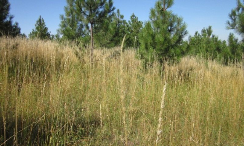
This site is located on level terrain, foot slopes and side slopes. It is on sites with more moisture than the pine/dry grass sites. Most of this site occurs under 2800’ of elevation. Reference state is characteristic of mature pine stands over snowberry, serviceberry, spirea, chokecherry, woods rose, nutka rose, and ninebark. Redstem ceanothus may be present as evidence of past fires. Fire disturbance is sporadic and currently in the mixed severity or stand replacing regimes. It would not be considered in the pine/savanna category due to lack of frequent ground fires. Overstory canopy cover of these mature pine stands will range from 40 – 60%. These mature pine stands will be subject to bark beetle kill, windfall, and fire. The understory shrubs will resprout quickly and pine regeneration will be dependent on pine seed placement and shrub competition.
The pine/snowberry plant association will be located on the drier topographic locations and the pine/ninebark plant association will be located on northern aspects. These sites have been subject to overgazing, introduced grass seeding and land conversion. Kentucky bluegrass and Canada bluegrass have invaded many of these sites dominating the understory. Sites on level terrain have been converted to crops, pasture, or urban land.
Major Land Resource Area
MLRA 043A
Northern Rocky Mountains
Subclasses
Stage
Provisional
Contributors
Gary Kuhn

Click on box and path labels to scroll to the respective text.