Natural Resources
Conservation Service
Ecological site R007XY163WA
Dry Loamy
Last updated: 3/11/2025
Accessed: 04/10/2026
General information
Provisional. A provisional ecological site description has undergone quality control and quality assurance review. It contains a working state and transition model and enough information to identify the ecological site.
MLRA notes
Major Land Resource Area (MLRA): 007X–Columbia Basin
This MLRA is in the Walla Walla Plateau section of the Columbia Plateaus province of the Intermontane Plateaus. The Columbia River flows through this MLRA, and the Snake and Yakima Rivers join the Columbia River within it. This MLRA is almost entirely underlain by Miocene basalt flows. Columbia River Basalt is covered in most areas with as much as 200 feet of eolian, lacustrine, and alluvial deposits. The dominant soil orders in this MLRA are Aridisols and Entisols. The soils in the area dominantly have a mesic temperature regime, an aridic moisture regime, and mixed mineralogy. They generally are moderately deep to very deep and well drained to excessively drained.
Classification relationships
Major Land Resource Area (MLRA): 007X – Columbia Basin
LRU – Common Resource Areas (CRA):
7.1 – Sandy Missoula Flood Deposits
7.5 – Yakima Valley – Pleistocene Lake Basins
Ecological site concept
Diagnostics:
Dry Loamy ecological site is an upland shrub steppe site that occurs on the driest and hottest portion of MLRA 007X including elevations below 1,000 feet, precipitation less than 7 inches, or south-facing slopes. This site occurs on terraces and hillslopes. The soils are moderately deep to deep silt loam and very fine sandy loam textures and have limited rock fragments (generally 10 percent or less) in the root-growing portions of the soil profile.
Between 4 and 7 inches of precipitation, the Dry Loamy ecological site is often extensive. But above 7 inches of precipitation, the Dry Loamy ecological site is much more limited in extent to south facing slopes. The Dry Loamy ecological site is much more extensive than the Calcareous Loam ecological site.
Dry Loamy ecological site has low species diversity. Spiny hopsage is a marker for MLRA 007X and identifies the Dry Loamy ecological site.
Principle Vegetative Drivers:
High temperatures coupled with low precipitation or dry, south slopes drive the vegetative expression on Dry Loamy ecological site. Annual production in quite limited.
Associated sites
| R007XY193WA |
Calcareous Loam |
|---|---|
| R007XY143WA |
Sandy Loam |
| R007XY449WA |
Sandy |
| R007XY140WA |
Sands |
| R007XY120WA |
Stony |
| R007XY001WA |
Very Shallow |
Table 1. Dominant plant species
| Tree |
Not specified |
|---|---|
| Shrub |
(1) Artemisia tridentata ssp. wyomingensis |
| Herbaceous |
(1) Pseudoroegneria spicata |
Physiographic features
The landscape is part of the Columbia basalt plateau. Dry Loamy ecological sites occur mostly on terraces, terrace escarpments and hillslopes.
Physiographic Division: Intermontane Plateau
Physiographic Province: Columbia Plateau
Physiographic Sections: Walla Walla Plateau Section
Table 2. Representative physiographic features
| Landforms |
(1)
Plateau
(2) Hills (3) Terrace (4) Hillslope (5) Bench |
|---|---|
| Flooding frequency | None |
| Ponding frequency | None |
| Elevation | 400 – 1,000 ft |
| Slope | 2 – 15% |
| Water table depth | 60 in |
| Aspect | W, NW, N, NE, E, SE, S, SW |
Table 3. Representative physiographic features (actual ranges)
| Flooding frequency | Not specified |
|---|---|
| Ponding frequency | Not specified |
| Elevation | 400 – 1,500 ft |
| Slope | 30% |
| Water table depth | Not specified |
Climatic features
MLRA 007X is the lowest, driest and hottest portions of the entire Columbia River region and the sagebrush-bluebunch wheatgrass zone. The Dry Loamy ecological site is generally in the driest and hottest portion of MLRA 007X (Benton, western Franklin, southern Grant and eastern Yakima counties.
The climate across MLRA 007X is characterized by moderately cold, wet winters, and hot, dry summers, with limited precipitation due to the rain shadow effect of the Cascades. The average annual precipitation is between 4 and 10 inches. Seventy to seventy-five percent of the precipitation comes late October through March as a mixture of rain and snow. For drier sites and lower elevations, precipitation that comes after March is not as effective for plant growth. But at higher elevations and higher precipitation, April and May rains make the difference between average and great production years. June through early October is dry. Freezing temperatures generally occur from late-October through early-April. Temperature extremes are -10 degrees Fahrenheit in winter and 110 degrees Fahrenheit in summer.
Table 4. Representative climatic features
| Frost-free period (characteristic range) | 150-180 days |
|---|---|
| Freeze-free period (characteristic range) | |
| Precipitation total (characteristic range) | 102-254 in |
| Frost-free period (actual range) | 140-200 days |
| Freeze-free period (actual range) | |
| Precipitation total (actual range) |
Influencing water features
A plant’s ability to grow on a site and overall plant production is determined by soil-water-plant relationships:
1. Whether rain and melting snow run off-site or infiltrate into the soil
2. Whether soil condition remain aerobic or become saturated and anaerobic
3. How quickly the soil reaches the wilting point
With adequate cover of live plants and litter, there are no restrictions on the Dry Loamy ecological site with water infiltrating into the soil. These sites are well drained.
Soil features
This ecological site components are dominantly Xeric and Aridic taxonomic subgroups of Haplargids, Haplocambids and Petrocambids great groups of the Aridisols taxonomic order. Soils are dominantly deep and deeper. Average available water capacity of about 6.0 inches (15.3 cm) in the 0 to 40 inches (0-100 cm) depth range.
Soil parent material is dominantly loess and alluvium derived from mixed sources over residuum.
The associated soils are Clenage, Matson, Scooteney and similar soils.
Table 5. Representative soil features
| Parent material |
(1)
Loess
(2) Alluvium |
|---|---|
| Family particle size |
(1) Coarse-silty (2) Coarse-loamy |
| Drainage class | Well drained |
| Depth to restrictive layer | 40 in |
| Soil depth | 40 in |
| Surface fragment cover <=3" | 15% |
| Surface fragment cover >3" | 5% |
| Available water capacity (0-40in) |
6 in |
| Calcium carbonate equivalent (Depth not specified) |
5% |
| Electrical conductivity (Depth not specified) |
4 mmhos/cm |
| Sodium adsorption ratio (Depth not specified) |
5 |
| Soil reaction (1:1 water) (0-10in) |
6.6 – 8.8 |
| Subsurface fragment volume <=3" (Depth not specified) |
20% |
| Subsurface fragment volume >3" (Depth not specified) |
10% |
Table 6. Representative soil features (actual values)
| Drainage class | Not specified |
|---|---|
| Depth to restrictive layer | Not specified |
| Soil depth | Not specified |
| Surface fragment cover <=3" | 30% |
| Surface fragment cover >3" | 25% |
| Available water capacity (0-40in) |
2.3 – 8.3 in |
| Calcium carbonate equivalent (Depth not specified) |
Not specified |
| Electrical conductivity (Depth not specified) |
Not specified |
| Sodium adsorption ratio (Depth not specified) |
Not specified |
| Soil reaction (1:1 water) (0-10in) |
Not specified |
| Subsurface fragment volume <=3" (Depth not specified) |
35% |
| Subsurface fragment volume >3" (Depth not specified) |
25% |
Ecological dynamics
Vegetation Dynamics:
Dry Loamy ecological site produces about 300 to 550 pounds per acre of biomass annually.
Stands of spiny hopsage and winterfat represent the northernmost outpost of species that are best represented in the vegetation of the Great Basin in Utah and Nevada. In the Great Basin spiny hopsage occurs in the transition between big sagebrush and shadscale.
The Dry Loamy ecological site has low species diversity. In the Reference State, Wyoming big sagebrush and spiny hopsage are the shrub layer while bluebunch wheatgrass and Sandberg bluegrass are layers two and three. Stands of Wyoming big sagebrush, spiny hopsage and Sandberg bluegrass are common (Daubenmire).
Dry Loamy ecological site tips easily to an Altered State and most Dry Loamy ecological sites in Washington have already crossed the threshold to communities dominated by cheatgrass and Russian thistle with an overstory of Wyoming big sagebrush and spiny hopsage. These sites are a fire waiting to happen.
Spiny hopsage is a one to four foot high salt desert shrub with small, paddle-shaped leaves. Stems are reddish brown with spiny, pointed ends. This shrub sheds its leaves and flowers by summer and becomes a woody gray thicket.
The stability and resiliency of the reference communities is directly linked to the health and vigor of bluebunch wheatgrass. More details about bluebunch physiology occur later. Research has found that the community remains resistant to medusahead invasion if the site maintains at least 0.8 plants per square foot of mid-sized bunchgrass (K. Davies, 2008). It is bluebunch wheatgrass that holds the system together. If bluebunch wheatgrass is lost, the ecosystem crashes or unravels.
The natural disturbance regime for grassland communities is periodic lightning-caused fires. The fire return intervals (FRI) listed in research for sagebrush steppe communities is quite variable. Ponderosa pine communities have the shortest FRI of about 10 to 20 years (Miller). The FRI increases as one moves to wetter forested sites or to dries shrub steppe communities. Given the uncertainties and opinions of reviewers, a mean of 75 years and a range of 50 to 100 was chosen for Wyoming big sagebrush communities (Rapid Assessment Model).
Some fires are spotty or do not burn hot enough to fully remove the sagebrush. Fires with light severity will remove less sagebrush and open smaller patches for grass and forb recovery, whereas the more severe fires will remove almost all the sagebrush and leave vast areas open to return to bunchgrass dominance. This is how the patchy distribution occurs. Rabbitbrush and horsebrush are sprouting shrubs and may also increase following fire.
The effect of fire on the community depends upon the severity of the burn. With a light to moderate fire there can be a mosaic of burned and unburned patches of sagebrush. Sagebrush can return to pre-burn conditions quickly. Bunchgrasses thrive as the fire does not get into the crown. With adequate soil moisture Idaho fescue and bluebunch wheatgrass can make tremendous growth the year after the fire. Other than impacting the sagebrush layer, the community is not affected.
A severe fire puts stress on the entire community. The sagebrush layer is completely removed. Spots or patches with heavy sagebrush are sterilized by the fire and must be seeded to prevent invasive species (annual grasses, tumble mustard) from totally occupying the site. Bluebunch wheatgrass and basin wildrye will have weak vigor for a few years but generally survive. Needle and thread is one native species that can increase via new seedlings.
The longer the site goes without fire and the more grazing pressure added, the more sagebrush and spiny hopsage cover increases, and the more bunchgrasses decline. As sagebrush cover increases bluebunch wheatgrass cover declines but individual plants may persist underneath the sagebrush. And, the dense sagebrush community phase is more vulnerable to outside pressures. Invasive species take advantage of available soil rooting spaces. The once extensive grass roots are largely absent. Soils are no longer receiving the organic inputs, and there is less surface cover by grass litter. Both water infiltration into the soil, and water percolation through the soil, are affected, leaving open soil space that is drier and more vulnerable to wind and water erosion, and invasion by undesirable species. Once these undesirable species have colonized, the site is at high risk of crossing a threshold if a disturbance such as fire were to occur.
Grazing is another common disturbance that occurs to this ecological site. Grazing pressure can be defined as heavy grazing intensity, or frequent grazing during reproductive growth, or season-long grazing (the same plant grazed more than once). As grazing pressure increases the plant community unravels in stages:
1. Bluebunch wheatgrass declines while Sandberg bluegrass, needle and thread and sagebrush increase
2. Needle and thread declines along with bluebunch wheatgrass
3. As the bunchgrasses continues to decline, invasive species such as cheatgrass and knapweed colonize the site
4. With further decline the site can become a sagebrush-cheatgrass community
Managing sagebrush steppe to improve the vigor and health of native bunchgrasses begins with an understanding of grass physiology. New growth each year begins from basal buds. Bluebunch wheatgrass plants rely principally on tillering, rather than establishment of new plants through natural reseeding. During seed formation, the growing points become elevated and are vulnerable to damage or removal.
If defoliated during the formation of seeds, bluebunch wheatgrass has limited capacity to tiller compared with other, more grazing resistant grasses (Caldwell et al., 1981). Repeated critical period grazing (boot stage through seed formation) is especially damaging. Over several years each native bunchgrass pasture should be rested during the critical period two out of every three years (approximately April 15–June 30). And each pasture should be rested the entire growing-season every third year (approximately March 1 – June 30).
In the spring each year it is important to monitor and maintain an adequate top growth:
(1) to replace basal buds annually, (2) to optimize regrowth following spring grazing, and (3) to protect the elevated growing points of bluebunch wheatgrass.
Bluebunch wheatgrass remains competitive if:
(1) Basal buds are replaced annually,
(2) Enough top-growth is maintained for growth and protection of growing points, and
(3) The timing of grazing and non-grazing is managed over a several-year period. Careful management of late spring grazing is especially critical
For more grazing management information refer to Range Technical Notes found in Section I Reference Lists of NRCS Field Office Technical Guide for Washington State.
In Washington, Wyoming sagebrush – bluebunch wheatgrass communities provide habitat for a variety of upland wildlife species.
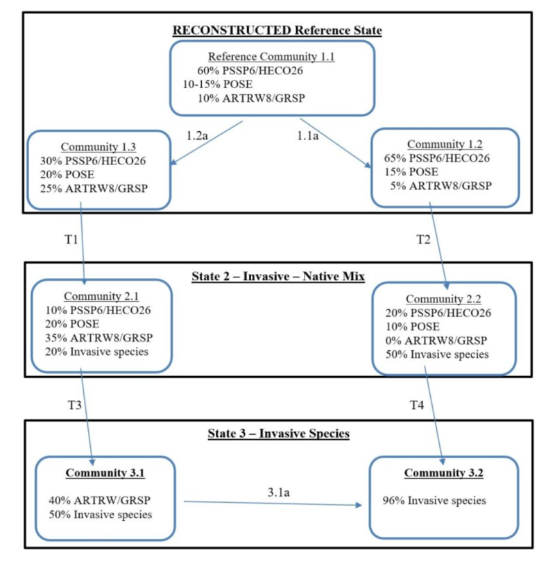
State and transition model
More interactive model formats are also available.
View Interactive Models
More interactive model formats are also available.
View Interactive Models
Click on state and transition labels to scroll to the respective text
Ecosystem states
State 2 submodel, plant communities
State 3 submodel, plant communities
State 1
Historic Reference
State 1 represents sagebrush steppe with no invasive or exotic weed species. All the functional, structural groups have one or more native species. A diverse native perennial community is more resistant to invasive annual species such as cheatgrass. Reference Community 1.1 is dominated by bluebunch wheatgrass with some sagebrush. Community 1.2 is even more strongly bunchgrass dominated. Community 1.3 has a heavy sage canopy but bluebunch remains a vital component in the community. Communities 1.1, 1,2 and 1.3 have enough bluebunch wheatgrass to shift to the other two communities and back again. These three community phases have high amounts of bunchgrass cover and are at low risk of moving to State 3. All communities in the reference state are at risk of moving to State 2. The seed source of cheatgrass is nearby and blowing onto most sites annually • Any community is at risk when shrub cover is high (40 percent or more) and there is little to no bluebunch wheatgrass.
Community 1.1
Bluebunch Wheatgrass, Needle and Thread, Sandberg Bluegrass, Wyoming Big Sagebrush, and Spiny Hop Sage
Community 1.1 is dominated by bluebunch wheatgrass with some sagebrush.
Figure 1. Annual production by plant type (representative values) or group (midpoint values)
Community 1.2
Bunchgrass Dominated
Community 1.2 is even more strongly bunchgrass dominated.
Community 1.3
Heavy Sagebrush
Community 1.3 has a heavy sagebrush canopy but bluebunch wheatgrass remains a vital component in the community.
Pathway 1.1A
Community 1.1 to 1.2
Result: Shift from Reference Community 1.1 to bunchgrass community 1.2. Shrub cover is all but eliminated, while bluebunch wheatgrass has a moderate increase in cover. Neither community have invasive species. Primary Trigger: Moderate-severity fire is complete enough and hot enough to remove most of the sagebrush. Fire is not hot enough to affect the soil conditions. The fire removes surface vegetation but has no impact on the crown of bunchgrasses. So, bunchgrasses and forbs return post-fire with good vigor. Post-fire the bunchgrasses are now more susceptible to grazing damage. Burned rangeland pastures will need two growing seasons recovery prior to resuming grazing, or to be lightly grazed but only during dormant season the first two years post-fire. Beyond two years for the bunchgrasses to expand, moderate grazing intensity, and both critical period and growing season deferments must be implemented on burned pastures. Ecological process: Fire kills most of the shrubs and this releases resources. Bluebunch wheatgrass and other bunchgrasses have good vigor post-fire and expand via tillering and new seedlings.
Pathway 1.2B
Community 1.1 to 1.3
Result: shift from reference community 1.1 to heavy sage community 1.3. There is a moderate increase in shrubs while bluebunch wheatgrass has a moderate corresponding decrease. Bluebunch wheatgrass, Wyoming big sagebrush/spiny hopsage and Sandberg bluegrass are co-dominant. Neither community have invasive species. Primary Trigger: grazing pressure (heavy grazing intensity, season-long grazing or frequent late-spring grazing) to bluebunch wheatgrass. Ecological process: consistent defoliation to bluebunch wheatgrass results in poor vigor and shrinking crowns. Spots with soil disturbances from badgers and rodents allow shrub seed to attain seed-soil contact to enable germination and establishment of new seedlings.
State 2
Current Potential
Narrative: State 2 represents a gradation along the transition between Reference State and State 3. State 2 is sagebrush steppe with the inclusion of invasive annuals such as cheatgrass, Russian thistle and mustard. Most of the native functional, structural groups are still represented by one or more species. Invasive species seed blows onto most sites annually seeking an opportunity to invade and colonize. With each loss of a native perennial plant, the site becomes less and less resistant to invasion. When cheatgrass and other invasives make seed for the next generation, the site has been colonized and will likely remain a component of the community. The loss of biological soil crusts is also a contributing factor to the invasion.
Community 2.1
Invasive Species, Shrubs, and Native Grasses
Community 2.2
Invasive Annual Grass and Broadleaf Weeds
State 3
Invaded
State 3 represents invasive annual species and has crossed a biological threshold. Virtually all the native functional, structural groups are missing. This state can occur with or without sagebrush. The main species can include cheatgrass, Japanese brome, medusahead, ventenata, mustard, prickly lettuce and diffuse knapweed. This state can occur with or without sagebrush.
Community 3.1
Shrub, Annual Grass, Sagebrush, and Cheatgrass
Community 3.2
Annual Grass and Cheatgrass
Pathway 3.1A
Community 3.1 to 3.2
Result: shift from Community 3.1 shrub-cheatgrass to Community 3.2 cheatgrass. Primary Trigger: Moderate intensity fire Ecological Process: fire kills remaining sagebrush and spiny hopsage plants. Cheatgrass and other invasive species fully occupy the site.
Transition T1A
State 1 to 2
T1 Result: transition from Community 1.3 in the Reference state with no invasive species to Community 2.1 in State 2 which is a mix of invasive and native species. This is a continuation of the decline that started with Pathway 1.2a. In Community 2.1 shrubs, native bunchgrasses and invasive species are co-dominant. Primary Trigger: grazing pressure to bluebunch wheatgrass. A secondary trigger would be a year with high moisture and a micro-flush of cheatgrass and other invasive species Ecological process. Consistent defoliation pressure to bluebunch wheatgrass results in poor vigor, shrinking crowns and some mortality. Most sites in the Reference State have some scattered cheatgrass seed as the seed blows onto most site annually. This seed is waiting for enough moisture to germinate and to compete with the native species for space, light and moisture. When the right year happens even pristine communities in the Reference State are susceptible to colonization by cheatgrass. Indicators: The occurrence of annual grasses on sites where they had been absent. Reduced cover and distance between bluebunch wheatgrass plants. T2 Result: shift from Community 1.2 in Reference State with no invasives species to community 2.2 in State 2 with a mix of native and invasive species. This is a continuation of the decline that started with Pathway 1.1a. This transition occurs when invasive species have colonized the site and are successfully reproducing. Primary Trigger: a repeat of moderate-severity fire. Repeated fire is more common in south Central Washington than elsewhere in MLRA 007X. Ecological Process: fire kills remaining sagebrush and spiny hopsage plants. This second fire is also detrimental to bluebunch wheatgrass plants and the exhibit poor vigor, shrinking crowns and mortality. Primary Trigger: moderate-severity fire happens again.
Transition T2A
State 2 to 3
T2A Result: shift from Community 2.1 (mix of native and invasive species) in State 2 to Community 3.1 (shrub-invasive species) in State 3. This is a continuation of the chain of decline which started with Pathway 1.2a and Transition T1. This transition occurs when the cover of native bunchgrasses is less than 10 percent and invasive species cover is at least 40 percent. Primary Trigger: heavy grazing pressure (heavy grazing intensity, season-long grazing or frequent late-spring grazing) to bluebunch wheatgrass and the entire community. Ecological Process: defoliation pressure continues and remaining bluebunch wheatgrass suffer mortality. Invasive species and shrubs expand via new seedlings to assume shared a position of codominance. T2A Result: Shift from Community 2.2 (native and invasive species mix) in State 2 to Community 3.2 (cheatgrass dominated) in State 3. Primary Trigger: moderate-severity fire happens again. Repeated fire is more common in south Central Washington than elsewhere in MLRA 007X. Ecological process: the last vestiges of native species are replaced by cheatgrass and other invasive species.
Additional community tables
Table 7. Community 1.1 plant community composition
| Group | Common name | Symbol | Scientific name | Annual production (lb/acre) | Foliar cover (%) | |
|---|---|---|---|---|---|---|
|
Shrub/Vine
|
||||||
| 1 | 55 | |||||
| Wyoming big sagebrush | ARTRW8 | Artemisia tridentata ssp. wyomingensis | – | – | ||
| spiny hopsage | GRSP | Grayia spinosa | – | – | ||
| 2 | 30 | |||||
| rubber rabbitbrush | ERNA10 | Ericameria nauseosa | – | – | ||
| yellow rabbitbrush | CHVI8 | Chrysothamnus viscidiflorus | – | – | ||
| spineless horsebrush | TECA2 | Tetradymia canescens | – | – | ||
|
Grass/Grasslike
|
||||||
| 3 | 350 | |||||
| bluebunch wheatgrass | PSSP6 | Pseudoroegneria spicata | – | – | ||
| needle and thread | HECO26 | Hesperostipa comata | – | – | ||
| 4 | 20 | |||||
| squirreltail | ELEL5 | Elymus elymoides | – | – | ||
| Indian ricegrass | ACHY | Achnatherum hymenoides | – | – | ||
| 5 | 85 | |||||
| Sandberg bluegrass | POSE | Poa secunda | – | – | ||
| sixweeks fescue | VUOC | Vulpia octoflora | – | – | ||
|
Forb
|
||||||
| 6 | 55 | |||||
| Munro's globemallow | SPMU2 | Sphaeralcea munroana | – | – | ||
| woolly plantain | PLPA2 | Plantago patagonica | – | – | ||
| fleabane | ERIGE2 | Erigeron | – | – | ||
| desertparsley | LOMAT | Lomatium | – | – | ||
| milkvetch | ASTRA | Astragalus | – | – | ||
| Cusick's sunflower | HECU2 | Helianthus cusickii | – | – | ||
| narrowleaf mock goldenweed | NEST5 | Nestotus stenophyllus | – | – | ||
| brodiaea | BRODI | Brodiaea | – | – | ||
| buckwheat | ERIOG | Eriogonum | – | – | ||
Interpretations
Supporting information
Inventory data references
Data to populate Reference Community came from several sources: (1) NRCS ecological sites from 2004, (2) Soil Conservation Service range sites from 1980s and 1990s, (3) Daubenmire’s habitat types, and (4) ecological systems from Natural Heritage Program
Other references
Boling M., Frazier B., Busacca, A., General Soil Map of Washington, Washington State University, 1998
Daubenmire, R., Steppe Vegetation of Washington, EB1446, March 1968
Davies, Kirk, Medusahead Dispersal and Establishment in Sagebrush Steppe Plant Communities, Rangeland Ecology & Management, 2008
Environmental Protection Agency, map of Level III and IV Ecoregions of Washington, June 2010
Miller, Baisan, Rose and Pacioretty, “Pre and Post Settlement Fire regimes in mountain Sagebrush communities: The Northern Intermountain Region
Natural Resources Conservation Service, map of Common Resource Areas of Washington, 2003
Rapid Assessment Reference Condition Model for Wyoming sagebrush, LANDFIRE project, 2008
Rocchio, Joseph & Crawford, Rex C., Ecological Systems of Washington State. A Guide to Identification. Washington State Department of Natural Resources, October 2015. Pages 156-161 Inter-Mountain Basin Big Sagebrush.
Rouse, Gerald, MLRA 8 Ecological Sites as referenced from Natural Resources Conservation Service-Washington FOTG, 2004
Soil Conservation Service, Range Sites for MLRA 8 from 1980s and 1990s
Tart, D., Kelley, P., and Schlafly, P., Rangeland Vegetation of the Yakima Indian reservation, August 1987, YIN Soil and Vegetation Survey
Approval
Kirt Walstad, 3/11/2025
Rangeland health reference sheet
Interpreting Indicators of Rangeland Health is a qualitative assessment protocol used to determine ecosystem condition based on benchmark characteristics described in the Reference Sheet. A suite of 17 (or more) indicators are typically considered in an assessment. The ecological site(s) representative of an assessment location must be known prior to applying the protocol and must be verified based on soils and climate. Current plant community cannot be used to identify the ecological site.
| Author(s)/participant(s) | |
|---|---|
| Contact for lead author | |
| Date | 01/28/2025 |
| Approved by | Kirt Walstad |
| Approval date | |
| Composition (Indicators 10 and 12) based on | Annual Production |
Indicators
-
Number and extent of rills:
-
Presence of water flow patterns:
-
Number and height of erosional pedestals or terracettes:
-
Bare ground from Ecological Site Description or other studies (rock, litter, lichen, moss, plant canopy are not bare ground):
-
Number of gullies and erosion associated with gullies:
-
Extent of wind scoured, blowouts and/or depositional areas:
-
Amount of litter movement (describe size and distance expected to travel):
-
Soil surface (top few mm) resistance to erosion (stability values are averages - most sites will show a range of values):
-
Soil surface structure and SOM content (include type of structure and A-horizon color and thickness):
-
Effect of community phase composition (relative proportion of different functional groups) and spatial distribution on infiltration and runoff:
-
Presence and thickness of compaction layer (usually none; describe soil profile features which may be mistaken for compaction on this site):
-
Functional/Structural Groups (list in order of descending dominance by above-ground annual-production or live foliar cover using symbols: >>, >, = to indicate much greater than, greater than, and equal to):
Dominant:
Sub-dominant:
Other:
Additional:
-
Amount of plant mortality and decadence (include which functional groups are expected to show mortality or decadence):
-
Average percent litter cover (%) and depth ( in):
-
Expected annual annual-production (this is TOTAL above-ground annual-production, not just forage annual-production):
-
Potential invasive (including noxious) species (native and non-native). List species which BOTH characterize degraded states and have the potential to become a dominant or co-dominant species on the ecological site if their future establishment and growth is not actively controlled by management interventions. Species that become dominant for only one to several years (e.g., short-term response to drought or wildfire) are not invasive plants. Note that unlike other indicators, we are describing what is NOT expected in the reference state for the ecological site:
-
Perennial plant reproductive capability:
Print Options
Sections
Font
Other
The Ecosystem Dynamics Interpretive Tool is an information system framework developed by the USDA-ARS Jornada Experimental Range, USDA Natural Resources Conservation Service, and New Mexico State University.
Click on box and path labels to scroll to the respective text.