Natural Resources
Conservation Service
Ecological site R007XY193WA
Calcareous Loam
Last updated: 4/01/2025
Accessed: 04/10/2026
General information
Provisional. A provisional ecological site description has undergone quality control and quality assurance review. It contains a working state and transition model and enough information to identify the ecological site.
MLRA notes
Major Land Resource Area (MLRA): 007X–Columbia Basin
This MLRA is in the Walla Walla Plateau section of the Columbia Plateaus province of the Intermontane Plateaus. The Columbia River flows through this MLRA, and the Snake and Yakima Rivers join the Columbia River within it. This MLRA is almost entirely underlain by Miocene basalt flows. Columbia River Basalt is covered in most areas with as much as 200 feet of eolian, lacustrine, and alluvial deposits. The dominant soil orders in this MLRA are Aridisols and Entisols. The soils in the area dominantly have a mesic temperature regime, an aridic moisture regime, and mixed mineralogy. They generally are moderately deep to very deep and well drained to excessively drained.
Classification relationships
Major Land Resource Area (MLRA): 007X – Columbia Basin
LRU – Common Resource Areas (CRA):
7.1 – Sandy Missoula Flood Deposits
7.2 – Silty Missoula Flood Deposits
7.3 – Dry Loess Islands
7.4 – Dry Yakima Folds
7.5 – Yakima Valley – Pleistocene Lake Basins
Ecological site concept
Diagnostics:
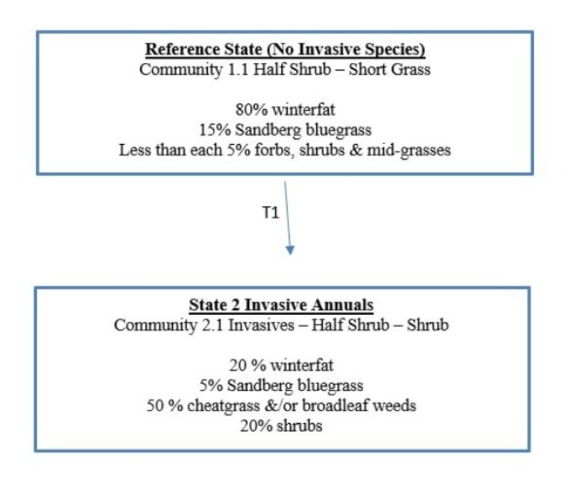
The Calcareous Loam ecological site is very limited in extent. It is an upland site that occurs as small, sharply defined patches on the driest and hottest portion of MLRA 007X. This site is typically found on terraces, benches, gently sloping lake beds and steep sideslopes of highly dissected plateaus. The soils are shallow, highly calcareous silt loam to very fine sandy loam textures. The depth to carbonates can vary from the surface to a depth of 5 to 14 inches. Soils are moderately alkaline and have limited rock fragments (generally 10 percent or less) in the root-growing portions of the soil profile.
This low producing site has two distinct layers – a scattering of short, half-shrubs in the top layer, and a sparse herbaceous layer of short, small bunchgrasses underneath. The plant community is predominately winterfat and Sandberg bluegrass. The native plant community on the Calcareous Loam ecological site is more stable and intact than the plant community on the Dry Loamy ecological site.
Principle Vegetative Drivers:
The soil drives the vegetative expression of this low productive site – shallow to moderately deep, highly calcareous silt soils and having a hardpan within 20 inches of depth.
Associated sites
| R007XY163WA |
Dry Loamy |
|---|---|
| R007XY120WA |
Stony |
| R007XY001WA |
Very Shallow |
| R007XY143WA |
Sandy Loam |
| R007XY449WA |
Sandy |
| R007XY140WA |
Sands |
Table 1. Dominant plant species
| Tree |
Not specified |
|---|---|
| Shrub |
(1) Krascheninnikovia lanata |
| Herbaceous |
(1) Poa secunda |
Click on box and path labels to scroll to the respective text.