Natural Resources
Conservation Service
Ecological site R023XY009NV
LOAMY BOTTOM 8-12 P.Z.
Last updated: 4/10/2025
Accessed: 04/05/2026
General information
Provisional. A provisional ecological site description has undergone quality control and quality assurance review. It contains a working state and transition model and enough information to identify the ecological site.
Ecological site concept
Currently there is only a draft of the initial concept for this ecological site. The initial concept for this site places it within the Seasonally Flooded Basin Wildrye Ecological Site Group. To view the General STM and other information available for this ESG please go to https://edit.jornada.nmsu.edu/catalogs/esg/023X/R023XY916NV
Production on this site is higher than the modal site, ranging between 2500 to 7000 lb/acre. This site is dominated by basin big sagebrush, and basin wildrye. It has a higher seasonal water table, at 30-60 inches. There is evidence that this ecological site may truly be a phase of the Wet Meadow (23XY089NV) site, which was not modeled as part of this report. This sagebrush-basin wildrye plant community often occurs as a result of stream channel entrenchment that has lowered a water table that once supported a poorly drained wet meadow community. This change in natural soil drainage is permanent and therefore a new ecological site potential is recognized for the degraded meadow community. This site has the same STM as the modal site with 3 stable states.
Associated sites
| F023XY034NV |
POBAT/SALIX/LEYMU |
|---|---|
| R023XY005NV |
DRY FLOODPLAIN |
| R023XY013NV |
DRY MEADOW |
| R023XY025NV |
WET MEADOW 14+ P.Z. |
Similar sites
| R023XY097NV |
LOAMY FAN 8-10 P.Z. LECI4-ELLAL codominant; less productive site |
|---|---|
| R023XY082NV |
LOAMY FAN 10-12 P.Z. POA++-ACTH7-LECI4 codominant grasses |
| R023XY005NV |
DRY FLOODPLAIN lower production; DISP and SAVE4 usually present |
| R023XY056NV |
LOAMY BOTTOM 12-16 P.Z. ARTRV dominant shrub |
Table 1. Dominant plant species
| Tree |
Not specified |
|---|---|
| Shrub |
(1) Artemisia tridentata ssp. tridentata |
| Herbaceous |
(1) Leymus cinereus |
Physiographic features
This site occurs on smooth, nearly level flood plains, lake terraces and inset fans. Slopes range from 0 to 15 percent. Elevation range from 3900 to 6500 feet.
Table 2. Representative physiographic features
| Landforms |
(1)
Flood plain
(2) Lake terrace (3) Inset fan |
|---|---|
| Flooding duration | Very brief (4 to 48 hours) to brief (2 to 7 days) |
| Flooding frequency | Rare to frequent |
| Elevation | 1,189 – 1,981 m |
| Slope | 0 – 15% |
| Water table depth | 23 – 213 cm |
| Aspect | Aspect is not a significant factor |
Climatic features
The climate associated with this site is semiarid and characterized by cool, moist winters and warm, dry summers. Average annual precipitation is 8 to 12 inches. Mean annual air temperature is 46 to 51 degrees F. The average growing season is about 90 to 120 days.
Nevada’s climate is predominantly arid, with large daily ranges of temperature, infrequent severe storms, heavy snowfall in the higher mountains, and great location variations with elevation. Three basic geographical factors largely influence Nevada’s climate: continentality, latitude, and elevation. Continentality is the most important factor. The strong continental effect is expressed in the form of both dryness and large temperature variations. Nevada lies on the eastern, lee side of the Sierra Nevada Range, a massive mountain barrier that markedly influences the climate of the State. The prevailing winds are from the west, and as the warm moist air from the Pacific Ocean ascend the western slopes of the Sierra Range, the air cools, condensation occurs and most of the moisture falls as precipitation. As the air descends the eastern slope, it is warmed by compression, and very little precipitation occurs. The effects of this mountain barrier are felt not only in the West but throughout the state, with the result that the lowlands of Nevada are largely desert or steppes. The temperature regime is also affected by the blocking of the inland-moving maritime air. Nevada sheltered from maritime winds, has a continental climate with well-developed seasons and the terrain responds quickly to changes in solar heating.
Nevada lies within the mid-latitude belt of prevailing westerly winds which occur most of the year. These winds bring frequent changes in weather during the late fall, winter and spring months, when most of the precipitation occurs. To the south of the mid-latitude westerlies, lies a zone of high pressure in subtropical latitudes, with a center over the Pacific Ocean. In the summer, this high-pressure belt shifts northward over the latitudes of Nevada, blocking storms from the ocean. The resulting weather is mostly clear and dry during the summer and early fall, with scattered thundershowers. The eastern portion of the state receives significant summer thunderstorms generated from monsoonal moisture pushed up from the Gulf of California, known as the North American monsoon. The monsoon system peaks in August and by October the monsoon high over the Western U.S. begins to weaken and the precipitation retreats southward towards the tropics (NOAA 2004).
Average annual precipitation is 16 to over 20 inches. Mean annual air temperature is 41 to 44 degrees F. The average growing season is about 50 to 70 days.
Mean annual precipitaion at the Bear Creek, Nevada SNOTEL station (170501020301) is 37.69 inches.
monthly mean precipitation is:
January 3.84; February 3.75; March 4.38; April 4.9;
May 3.99; June 2.82; July .95; August 1.66;
September 1.22; October 2.12;
November 3.67; December 4.38.
Table 3. Representative climatic features
| Frost-free period (average) | 105 days |
|---|---|
| Freeze-free period (average) | |
| Precipitation total (average) | 254 mm |
Figure 1. Monthly precipitation range
Figure 2. Monthly average minimum and maximum temperature
Figure 3. Annual precipitation pattern
Figure 4. Annual average temperature pattern
Influencing water features
Additional moisture is added to the site from stream flooding or run-in from higher elevations. In many areas, this plant community occurs as a result of stream channel entrenchment that has lowered a water table that once supported a poorly drained wet meadow community.
Soil features
The soils associated with this site are very deep and are formed in alluvium derived from volcanic rocks and pyroclastic materials. They typically have high available water capacity. These soils are moderately well drained to somewhat poorly drained and have a seasonally high water table at depths of 9 to 60 inches. Additional moisture is added to the site from stream flooding or run-in from higher elevations. In many areas, this plant community occurs as a result of stream channel entrenchment that has lowered a water table that once supported a poorly drained wet meadow community. The soils have a mollic epipedon. The soil series associated with this site include: Emagert, Voltaire, and Woofus.
Table 4. Representative soil features
| Parent material |
(1)
Alluvium
–
pyroclastic rock
|
|---|---|
| Surface texture |
(1) Loam (2) Silt loam |
| Family particle size |
(1) Loamy |
| Drainage class | Moderately well drained to very poorly drained |
| Permeability class | Moderately slow to moderately rapid |
| Soil depth | 183 – 213 cm |
| Surface fragment cover <=3" | 0% |
| Surface fragment cover >3" | 0% |
| Available water capacity (0-101.6cm) |
12.7 – 20.83 cm |
| Calcium carbonate equivalent (0-101.6cm) |
0 – 10% |
| Electrical conductivity (0-101.6cm) |
0 – 8 mmhos/cm |
| Sodium adsorption ratio (0-101.6cm) |
0 – 12 |
| Soil reaction (1:1 water) (0-101.6cm) |
6.1 – 8.4 |
| Subsurface fragment volume <=3" (Depth not specified) |
4 – 0% |
| Subsurface fragment volume >3" (Depth not specified) |
0% |
Ecological dynamics
Where management results in abusive grazing use by livestock and/or feral horses, basin wildrye and Nevada bluegrass will decrease while sagebrush and rabbitbrush increase. Periodic fire on this site will increase the abundance of native grasses, but can also increase abundance of rabbitbrush due to its crown sprouting ability. Species likely to invade this are Russian thistle, halogeton and cheatgrass.
Fire Ecology:
Fire return intervals in basin big sagebrush are intermediate between mountain big sagebrush (15 to 25 years) and Wyoming big sagebrush (10 to 70 years). A naturally wide variation in fire frequency in this system is expected. Basin big sagebrush is readily killed when aboveground plant parts are charred by fire. Prolific seed production from nearby unburned plants coupled with high germination rates enables seedlings to establish rapidly following fire. Basin wildrye is top-killed by fire. Older basin wildrye plants with large proportions of dead material within the perennial crown can be expected to show higher mortality due to fire than younger plants having little debris. Basin wildrye is generally tolerant of fire but may be damaged by early season fire combined with dry soil conditions. Nevada bluegrass is generally unharmed by fire. It produces little litter, and its small bunch size and sparse litter reduces the amount of heat transferred to perennating buds in the soil. Thickspike wheatgrass is tolerant of fire. Subsurface growing points and primarily rhizomatous reproduction may explain its ability to increase rapidly (within 2-5 years) following burning. Mat muhly is top killed be fire. Fire does not harm mat muhly to any great extent because the rhizome buds are insulated by the soil. There is a greater than 65% chance that at least 50% of the plants in a population will survive a fire.
State and transition model
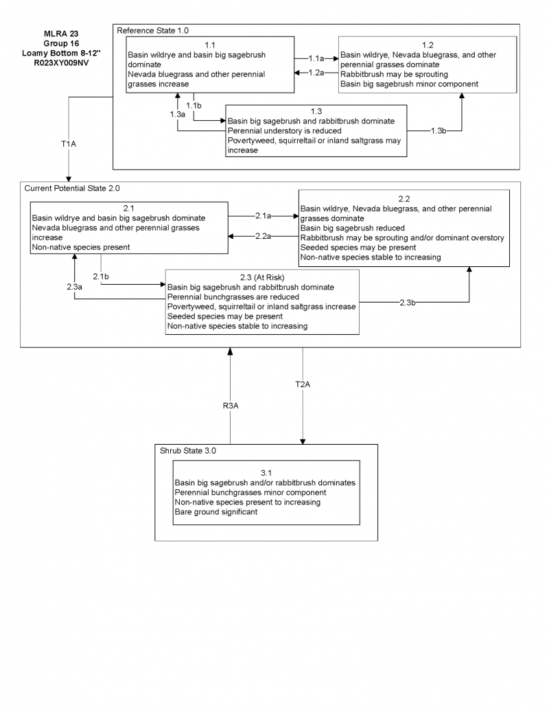
More interactive model formats are also available.
View Interactive Models
Click on state and transition labels to scroll to the respective text
Ecosystem states
State 1 submodel, plant communities
State 1
Reference Plant Community
Community 1.1
Reference Plant Community
The reference plant community is dominated by basin wildrye. Potential vegetative composition is about 70% grasses, 10% forbs and 20% shrubs. Approximate ground cover (basal and crown) is about 40 to 60 percent.
Figure 5. Annual production by plant type (representative values) or group (midpoint values)
Table 5. Annual production by plant type
| Plant type | Low (kg/hectare) |
Representative value (kg/hectare) |
High (kg/hectare) |
|---|---|---|---|
| Grass/Grasslike | 1961 | 3531 | 5492 |
| Shrub/Vine | 560 | 1009 | 1569 |
| Forb | 280 | 504 | 785 |
| Total | 2801 | 5044 | 7846 |
Additional community tables
Table 6. Community 1.1 plant community composition
| Group | Common name | Symbol | Scientific name | Annual production (kg/hectare) | Foliar cover (%) | |
|---|---|---|---|---|---|---|
|
Grass/Grasslike
|
||||||
| 1 | Primary Perennial Grasses | 3732–5296 | ||||
| basin wildrye | LECI4 | Leymus cinereus | 3278–3783 | – | ||
| mat muhly | MURI | Muhlenbergia richardsonis | 101–504 | – | ||
| thickspike wheatgrass | ELLAL | Elymus lanceolatus ssp. lanceolatus | 101–504 | – | ||
| 2 | Secondary Perennial Grasses/Grasslikes | 252–504 | ||||
| sedge | CAREX | Carex | 26–151 | – | ||
| beardless wildrye | LETR5 | Leymus triticoides | 26–151 | – | ||
|
Forb
|
||||||
| 3 | Perennial | 252–757 | ||||
| povertyweed | IVAX | Iva axillaris | 26–252 | – | ||
| lupine | LUPIN | Lupinus | 26–252 | – | ||
| ragwort | SENEC | Senecio | 26–252 | – | ||
|
Shrub/Vine
|
||||||
| 4 | Primary Shrubs | 252–504 | ||||
| basin big sagebrush | ARTRT | Artemisia tridentata ssp. tridentata | 252–504 | – | ||
| 5 | Secondary Shrubs | 1–252 | ||||
| yellow rabbitbrush | CHVI8 | Chrysothamnus viscidiflorus | 50–101 | – | ||
| rubber rabbitbrush | ERNAN5 | Ericameria nauseosa ssp. nauseosa var. nauseosa | 50–101 | – | ||
| currant | RIBES | Ribes | 50–101 | – | ||
| Woods' rose | ROWO | Rosa woodsii | 50–101 | – | ||
| willow | SALIX | Salix | 50–101 | – | ||
Interpretations
Animal community
Livestock Interpretations:
This site is suitable for livestock grazing. Grazing management should be keyed to perennial grass production. The early growth and abundant production of basin wildrye make it a valuable source of forage for livestock. It is important forage for cattle and is readily grazed by cattle and horses in early spring and fall. Though coarse-textured during the winter, basin wildrye may be utilized more frequently by livestock and wildlife when snow has covered low shrubs and other grasses. Nevada bluegrass is a widespread forage grass. It is one of the earliest grasses in the spring and is sought by domestic livestock and several wildlife species. Nevada bluegrass is a palatable species, but its production is closely tied to weather conditions. It produces little forage in drought years, making it a less dependable food source than other perennial bunchgrasses. Thickspike wheatgrass is palatable to all classes of livestock and wildlife. It is a preferred feed for cattle, sheep, horses, and elk in spring and is considered a desirable feed for deer and antelope in spring. It is considered a desirable feed for cattle, sheep, and horses in summer, fall, and winter. Thickspike wheatgrass's extensive rhizome system allows established stands to withstand heavy grazing and trampling. Young mat muhly is readily eaten by livestock. Plants become less palatable as they mature. Mat muhly plants usually grow in scattered patches, so they are seldom sufficiently abundant to be of major importance to livestock. In the northern part of its range, mat muhly is rated as good to very good forage for cattle and horses and fairly good for domestic sheep. Basin big sagebrush may serve as emergency food during severe winter weather, but it is not usually sought out by livestock.
Stocking rates vary over time depending upon season of use, climate variations, site, and previous and current management goals. A safe starting stocking rate is an estimated stocking rate that is fine tuned by the client by adaptive management through the year and from year to year.
Wildlife Interpretations:
Basin big sagebrush is the least palatable of all the subspecies of big sagebrush. Basin big sagebrush is browsed by mule deer from fall to early spring, but is not preferred. Sagebrush-grassland communities provide critical sage-grouse breeding and nesting habitats. Meadows surrounded by sagebrush may be used as feeding and strutting grounds. Sagebrush is a crucial component of their diet year-round, and sage-grouse select sagebrush almost exclusively for cover. Sage-grouse prefer mountain big sagebrush and Wyoming big sagebrush communities to basin big sagebrush communities. Basin wildrye provides winter forage for mule deer, though use is often low compared to other native grasses. Basin wildrye provides summer forage for black-tailed jackrabbits. Because basin wildrye remains green throughout early summer, it remains available for small mammal forage for longer time than other grasses. Nevada bluegrass is desirable for pronghorn antelope and mule deer in the spring and preferable in the spring, summer, and fall for elk and desirable as part of their winter range. In the spring, it is a preferred feed for elk and is considered desirable feed for deer and antelope. It is desirable feed for elk during summer, fall, and winter. Thickspike wheatgrass is also a component of black-tailed jackrabbit diets. Thickspike wheatgrass provides some cover for small mammals and birds. The palatability of mat muhly for wildlife species has been rated as fair to poor.
Hydrological functions
Runoff is low to medium. Permeability is slow to moderately slow.
Recreational uses
Aesthetic value is derived from the diverse floral and faunal composition and the colorful flowering of wild flowers and shrubs during the spring and early summer. This site offers rewarding opportunities to photographers and for nature study. This site is used for camping and hiking and has potential for upland and big game hunting.
Other products
Some Native American peoples used the bark of big sagebrush to make rope and baskets. Basin wildrye was used as bedding for various Native American ceremonies, providing a cool place for dancers to stand.
Other information
Basin big sagebrush shows high potential for range restoration and soil stabilization. Basin big sagebrush grows rapidly and spreads readily from seed. Basin wildrye is useful in mine reclamation, fire rehabilitation and stabilizing disturbed areas. Its usefulness in range seeding, however, may be limited by initially weak stand establishment. Thickspike is a good revegetation species because it forms tight sod under dry rangeland conditions, has good seedling strength, and performs well in low fertility or eroded sites. It does not compete well with aggressive introduced grasses during the establishment period, but are very compatible with slower developing natives, bluebunch wheatgrass (Pseudoroegneria spicata), western wheatgrass (Pascopyrum smithii), and needlegrass (Achnatherum spp.) species. It’s drought tolerance combined with rhizomes, fibrous root systems, and good seedling vigor make these species ideal for reclamation in areas receiving 8 to 20 inches annual precipitation. Thickspike wheatgrass can be used for hay production and will make nutritious feed, but is more suited to pasture use.
Supporting information
Type locality
| Location 1: Washoe County, NV | |
|---|---|
| Township/Range/Section | T37N R19E S18 |
| Latitude | 41° 5′ 18″ |
| Longitude | 119° 53′ 38″ |
| General legal description | NW 1/4, Along north side of Nevada Highway 81, on floodplain of Wall Creek, Duck Flat area, Washoe County, Nevada. This site is also found in Humboldt County, Nevada. |
Other references
Fire Effects Information System (Online; http://www.fs.fed.us/database/feis/plants/).
USDA-NRCS Plants Database (Online; http://www.plants.usda.gov).
Great Basin Ecological Site Development Project: State and Transition Models for Major Land Resource Area 23, Nevada and portions of California (Online; https://naes.agnt.unr.edu/PMS/Pubs/2019-4060.pdf)
Contributors
BH/SW/GKB
T Stringham (UNR under contract with BLM)
Rangeland health reference sheet
Interpreting Indicators of Rangeland Health is a qualitative assessment protocol used to determine ecosystem condition based on benchmark characteristics described in the Reference Sheet. A suite of 17 (or more) indicators are typically considered in an assessment. The ecological site(s) representative of an assessment location must be known prior to applying the protocol and must be verified based on soils and climate. Current plant community cannot be used to identify the ecological site.
| Author(s)/participant(s) | PNOVAK-ECHENIQUE |
|---|---|
| Contact for lead author | State Rangeland Management Specialist |
| Date | 11/16/2012 |
| Approved by | Kendra Moseley |
| Approval date | |
| Composition (Indicators 10 and 12) based on | Annual Production |
Indicators
-
Number and extent of rills:
None -
Presence of water flow patterns:
None -
Number and height of erosional pedestals or terracettes:
None -
Bare ground from Ecological Site Description or other studies (rock, litter, lichen, moss, plant canopy are not bare ground):
Bare Ground ± 10%. -
Number of gullies and erosion associated with gullies:
None -
Extent of wind scoured, blowouts and/or depositional areas:
None -
Amount of litter movement (describe size and distance expected to travel):
Fine litter (foliage of grasses and annual & perennial forbs) only expected to move during periods of flooding by adjacent streams. Persistent litter (large woody material) will remain in place except during large flooding events. -
Soil surface (top few mm) resistance to erosion (stability values are averages - most sites will show a range of values):
Soil stability values will range from 4 to 6. (To be field tested.) -
Soil surface structure and SOM content (include type of structure and A-horizon color and thickness):
Soil surface structure is thick platy or subangular blocky. Soil surface colors are dark grays or browns and the soils have thick mollic epipedons. Organic matter can range from 2 to 3 percent for much of the upper 20 inches. -
Effect of community phase composition (relative proportion of different functional groups) and spatial distribution on infiltration and runoff:
Deep-rooted, perennial, bunchgrasses slow runoff and increase infiltration. Tall stature and relatively coarse foliage of basin wildrye and associated litter break raindrop impact and provide opportunity for snow catch and snow accumulation on site. -
Presence and thickness of compaction layer (usually none; describe soil profile features which may be mistaken for compaction on this site):
None - Massive subsurface layers are not to be interpreted as compaction. -
Functional/Structural Groups (list in order of descending dominance by above-ground annual-production or live foliar cover using symbols: >>, >, = to indicate much greater than, greater than, and equal to):
Dominant:
Tall-statured, deep-rooted, cool season, perennial bunchgrassesSub-dominant:
relatively short-statured, deep-rooted, cool season, perennial bunchgrasses > rhizomatous, cool season, perennial grasses > deep-rooted, cool season, perennial forbs = tall shrubs>cool-season grass-like plants > fibrous, shallow-rooted, cool season, annual and perennial forbs.Other:
Additional:
-
Amount of plant mortality and decadence (include which functional groups are expected to show mortality or decadence):
Dead branches within individual shrubs common; standing dead shrub canopy material may be as much as 25% of total woody canopy. -
Average percent litter cover (%) and depth ( in):
Under canopy and between plant interspaces up to 80% and litter depth is ± 0.5 inch. -
Expected annual annual-production (this is TOTAL above-ground annual-production, not just forage annual-production):
For normal or average growing season (through June) ± 4500 lbs/ac; Favorable years± 2500 lbs/ac; Unfavorable years ±7000 lbs/ac -
Potential invasive (including noxious) species (native and non-native). List species which BOTH characterize degraded states and have the potential to become a dominant or co-dominant species on the ecological site if their future establishment and growth is not actively controlled by management interventions. Species that become dominant for only one to several years (e.g., short-term response to drought or wildfire) are not invasive plants. Note that unlike other indicators, we are describing what is NOT expected in the reference state for the ecological site:
Potential invaders include annual mustards, thistles, annual kochia, pigweed, perennial pepperweed, and saltcedar. -
Perennial plant reproductive capability:
All functional groups should reproduce in most years.
Print Options
Sections
Font
Other
The Ecosystem Dynamics Interpretive Tool is an information system framework developed by the USDA-ARS Jornada Experimental Range, USDA Natural Resources Conservation Service, and New Mexico State University.
Click on box and path labels to scroll to the respective text.