Natural Resources
Conservation Service
Ecological site R023XY050NV
STONY GRANITIC SLOPE 14+ P.Z.
Last updated: 4/10/2025
Accessed: 04/02/2026
General information
Provisional. A provisional ecological site description has undergone quality control and quality assurance review. It contains a working state and transition model and enough information to identify the ecological site.
Ecological site concept
Currently there is only a draft of the initial concept for this ecological site. The initial concept for this site places it within the Ashy or Loamy Skeletal Mod Deep 10-20 PZ High-Resilience Mountain Big Sagebrush and Idaho Fescue Ecological Site Group. To view the General STM and other information available for this ESG please go to https://edit.jornada.nmsu.edu/catalogs/esg/023X/R023XY906NV
This site is less productive than the modal site with only 900 lbs/ac in normal years. Slopes typically range from 30 to 50 percent with elevations from 7000 – 9000 ft. Soils are doughtier than others at this elevation due to low available water capacity and the wind-prone physiographic setting these sites occur within. The dominant grasses that grow in this site are bluebunch wheatgrass and basin wildrye. This site is likely similar to the group modal site with 2 stable states, however this site was not seen during site visits for the group report.
Associated sites
| R023XY008NV |
MOUNTAIN RIDGE |
|---|---|
| R023XY014NV |
SHALLOW LOAM 14+ P.Z. |
| R023XY019NV |
LOAMY 16+ P.Z. |
Similar sites
| R023XY049NV |
GRANITIC SOUTH SLOPE 8-12 P.Z. PSSPS and ACTH7 most prevalent grass species; less productive site; occurs at lower elevations |
|---|---|
| R023XY016NV |
SOUTH SLOPE 12-16 P.Z. more productive site |
| R023XY043NV |
GRANITIC SLOPE 14-16 P.Z. PSSPS-FEID codominant |
| R023XY018NV |
STONY SOUTH SLOPE 12-16 P.Z. PSSPS-LECI4 codominant |
Table 1. Dominant plant species
| Tree |
Not specified |
|---|---|
| Shrub |
(1) Artemisia tridentata ssp. vaseyana |
| Herbaceous |
(1) Pseudoroegneria spicata ssp. spicata |
Physiographic features
This site occurs on convex mountain summits and backslopes. This plant community can occur on all aspects, but is mainly found on sideslopes having a southerly aspect. Slopes range from 30 to 50 percent. Elevations are 7000 to 9000 feet.
Table 2. Representative physiographic features
| Landforms |
(1)
Mountain
|
|---|---|
| Elevation | 7,000 – 9,000 ft |
| Slope | 30 – 50% |
| Aspect | Aspect is not a significant factor |
Climatic features
The climate associated with this site is semiarid and characterized by cool, moist winters and warm, dry summers. Average annual precipitation is 14 to over 20 inches. Mean annual air temperature is 38 to 43 degrees F. The average growing season is about 30 to 60 days.
Nevada’s climate is predominantly arid, with large daily ranges of temperature, infrequent severe storms, heavy snowfall in the higher mountains, and great location variations with elevation. Three basic geographical factors largely influence Nevada’s climate: continentality, latitude, and elevation. Continentality is the most important factor. The strong continental effect is expressed in the form of both dryness and large temperature variations. Nevada lies on the eastern, lee side of the Sierra Nevada Range, a massive mountain barrier that markedly influences the climate of the State. The prevailing winds are from the west, and as the warm moist air from the Pacific Ocean ascend the western slopes of the Sierra Range, the air cools, condensation occurs and most of the moisture falls as precipitation. As the air descends the eastern slope, it is warmed by compression, and very little precipitation occurs. The effects of this mountain barrier are felt not only in the West but throughout the state, with the result that the lowlands of Nevada are largely desert or steppes. The temperature regime is also affected by the blocking of the inland-moving maritime air. Nevada sheltered from maritime winds, has a continental climate with well-developed seasons and the terrain responds quickly to changes in solar heating.
Nevada lies within the mid-latitude belt of prevailing westerly winds which occur most of the year. These winds bring frequent changes in weather during the late fall, winter and spring months, when most of the precipitation occurs. To the south of the mid-latitude westerlies, lies a zone of high pressure in subtropical latitudes, with a center over the Pacific Ocean. In the summer, this high-pressure belt shifts northward over the latitudes of Nevada, blocking storms from the ocean. The resulting weather is mostly clear and dry during the summer and early fall, with scattered thundershowers. The eastern portion of the state receives significant summer thunderstorms generated from monsoonal moisture pushed up from the Gulf of California, known as the North American monsoon. The monsoon system peaks in August and by October the monsoon high over the Western U.S. begins to weaken and the precipitation retreats southward towards the tropics (NOAA 2004).
Average annual precipitation is 16 to over 20 inches. Mean annual air temperature is 41 to 44 degrees F. The average growing season is about 50 to 70 days.
Mean annual precipitaion at the Bear Creek, Nevada SNOTEL station (170501020301) is 37.69 inches.
monthly mean precipitation is:
January 3.84; February 3.75; March 4.38; April 4.9;
May 3.99; June 2.82; July .95; August 1.66;
September 1.22; October 2.12;
November 3.67; December 4.38.
Table 3. Representative climatic features
| Frost-free period (average) | 45 days |
|---|---|
| Freeze-free period (average) | |
| Precipitation total (average) | 17 in |
Figure 1. Monthly average minimum and maximum temperature
Figure 2. Annual precipitation pattern
Figure 3. Annual average temperature pattern
Influencing water features
There are no influencing water features associated with this site.
Soil features
The soils associated with this site have formed in residuum and colluvium derived from granitic parent material. These soils are deep, well drained, and have high amounts of surface boulders and stones. The soils have a low available water capacity and, coupled with their wind-prone physiographic setting, are quite droughty relative to most other soils at this elevation. The soils have a mollic epipedon and an argilllic horizon. The soil series associated with this site include: Granipeak.
Table 4. Representative soil features
| Surface texture |
(1) Very bouldery coarse sandy loam |
|---|---|
| Family particle size |
(1) Loamy |
| Drainage class | Well drained |
| Permeability class | Moderate |
| Soil depth | 40 – 60 in |
| Surface fragment cover <=3" | 10 – 14% |
| Surface fragment cover >3" | 35 – 40% |
| Available water capacity (0-40in) |
3.2 – 3.3 in |
| Calcium carbonate equivalent (0-40in) |
Not specified |
| Electrical conductivity (0-40in) |
2 mmhos/cm |
| Sodium adsorption ratio (0-40in) |
Not specified |
| Soil reaction (1:1 water) (0-40in) |
6.1 – 7.3 |
| Subsurface fragment volume <=3" (Depth not specified) |
14 – 16% |
| Subsurface fragment volume >3" (Depth not specified) |
35 – 40% |
Ecological dynamics
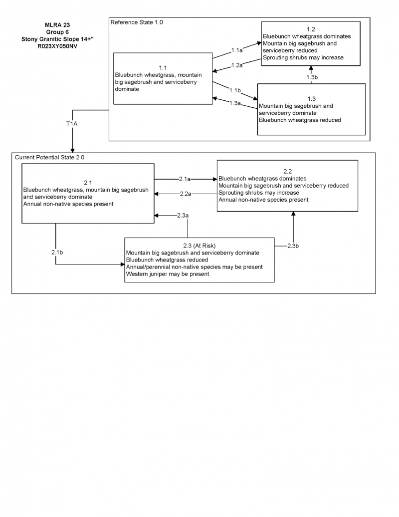
Where management results in abusive livestock use, mountain big sagebrush and snowberry will dominate this site.
Fire Ecology:
Presettlement fire return intervals in mountain big sagebrush communities varied from 15 to 25 years. Plants are readily killed in all seasons, even light severity fires. Mountain big sagebrush is highly susceptible to injury from fire. It is often top-killed by fire and will not resprout. Aboveground parts of Utah serviceberry may be killed or consumed under fire conditions with sufficient flame lengths. Utah serviceberry may be slightly harmed by fire, depending on moisture conditions, but is generally considered to be fire tolerant. Utah serviceberry sprouts from the root crown following fire. Soil moisture is important to aid sprouting. Fires top-kill mountain snowberry. Although plant survival may be variable, mountain snowberry root crowns usually survive even severe fires. Mountain snowberry sprouts from basal buds at the root crown following fire. Oceanspray is top-killed by fire. Oceanspray is only moderately resistant to fire, but is well adapted to disturbance by fire. Oceanspray survives fire by regenerating from soil-stored seed or sprouting from surviving root crowns. Full recovery from a fire disturbance can be expected in 5 to 10 years. Burning bluebunch wheatgrass may remove most of the aboveground biomass but does not usually result in plant mortality. Bluebunch wheatgrass is generally favored by burning. Burning stimulates flowering and seed production. However, season of burning affects mortality. Basin wildrye is top-killed by fire. Older basin wildrye plants with large proportions of dead material within the perennial crown can be expected to show higher mortality due to fire than younger plants having little debris. Basin wildrye is generally tolerant of fire but may be damaged by early season fire combined with dry soil conditions. Little specific information is available on adaptations of Letterman's needlegrass to fire. It is morphologically similar to Columbia needlegrass, which is only slightly to moderately damaged by fire. Season of burn affects the plant's ability to survive a fire. Post-fire regeneration is through seeding and tillering. Canby's bluegrass is generally unharmed by fire. It produces little litter, and its small bunch size and sparse litter reduces the amount of heat transferred to perennating buds in the soil. Its rapid maturation in the spring also reduces fire damage, since it is dormant when most fires occur. Cusick’s bluegrass is unharmed to slightly harmed by light-severity fall fires. Cusick’s bluegrass regenerates after fire from seed and by tillering.
State and transition model

More interactive model formats are also available.
View Interactive Models
Click on state and transition labels to scroll to the respective text
Ecosystem states
State 1 submodel, plant communities
State 1
Reference Plant Community
Community 1.1
Reference Plant Community
The reference plant community is dominated by mountain big sagebrush and bluebunch wheatgrass. Important associated species include snowberry, Utah serviceberry and bush oceanspray (usually associated with the numerous rock outcrops). Potential vegetative composition is about 55% grasses, 10% forbs and 35% shrubs. Approximate ground cover (basal and crown) is about 20 to 35 percent.
Figure 4. Annual production by plant type (representative values) or group (midpoint values)
Table 5. Annual production by plant type
| Plant type | Low (lb/acre) |
Representative value (lb/acre) |
High (lb/acre) |
|---|---|---|---|
| Grass/Grasslike | 385 | 495 | 660 |
| Shrub/Vine | 245 | 315 | 420 |
| Forb | 70 | 90 | 120 |
| Total | 700 | 900 | 1200 |
Additional community tables
Table 6. Community 1.1 plant community composition
| Group | Common name | Symbol | Scientific name | Annual production (lb/acre) | Foliar cover (%) | |
|---|---|---|---|---|---|---|
|
Grass/Grasslike
|
||||||
| 1 | Primary Perennial Grasses | 396–585 | ||||
| bluebunch wheatgrass | PSSPS | Pseudoroegneria spicata ssp. spicata | 270–360 | – | ||
| basin wildrye | LECI4 | Leymus cinereus | 90–135 | – | ||
| Letterman's needlegrass | ACLE9 | Achnatherum lettermanii | 18–45 | – | ||
| Cusick's bluegrass | POCUE2 | Poa cusickii ssp. epilis | 9–22 | – | ||
| 2 | Secondary Perennial Grasses/Grasslikes | 45–90 | ||||
| Columbia needlegrass | ACNEN2 | Achnatherum nelsonii ssp. nelsonii | 5–27 | – | ||
| Thurber's needlegrass | ACTH7 | Achnatherum thurberianum | 5–27 | – | ||
| mountain brome | BRMA4 | Bromus marginatus | 5–27 | – | ||
| sedge | CAREX | Carex | 5–27 | – | ||
| slender wheatgrass | ELTRT | Elymus trachycaulus ssp. trachycaulus | 5–27 | – | ||
| Idaho fescue | FEID | Festuca idahoensis | 5–27 | – | ||
| purple oniongrass | MESP | Melica spectabilis | 5–27 | – | ||
|
Forb
|
||||||
| 3 | Perennial | 45–135 | ||||
| buckwheat | ERIOG | Eriogonum | 5–27 | – | ||
| wallflower | ERYSI | Erysimum | 5–27 | – | ||
| lupine | LUPIN | Lupinus | 5–27 | – | ||
| bluebells | MERTE | Mertensia | 5–27 | – | ||
| phacelia | PHACE | Phacelia | 5–27 | – | ||
| phlox | PHLOX | Phlox | 5–27 | – | ||
| mule-ears | WYAM | Wyethia amplexicaulis | 5–27 | – | ||
|
Shrub/Vine
|
||||||
| 4 | Primary Shrubs | 171–360 | ||||
| mountain big sagebrush | ARTRV | Artemisia tridentata ssp. vaseyana | 90–180 | – | ||
| Utah serviceberry | AMUT | Amelanchier utahensis | 45–90 | – | ||
| rockspirea | HODU | Holodiscus dumosus | 18–45 | – | ||
| mountain snowberry | SYOR2 | Symphoricarpos oreophilus | 18–45 | – | ||
| 5 | Secondary Shrubs | 18–72 | ||||
| yellow rabbitbrush | CHVI8 | Chrysothamnus viscidiflorus | 9–27 | – | ||
| antelope bitterbrush | PUTR2 | Purshia tridentata | 9–27 | – | ||
Interpretations
Animal community
Livestock Interpretations:
This site has limited value for livestock grazing due to steep slopes and stony surfaces. Bluebunch wheatgrass is considered one of the most important forage grass species on western rangelands for livestock. Although bluebunch wheatgrass can be a crucial source of forage, it is not necessarily the most highly preferred species. The early growth and abundant production of basin wildrye make it a valuable source of forage for livestock. It is important forage for cattle and is readily grazed by cattle and horses in early spring and fall. Though coarse-textured during the winter, basin wildrye may be utilized more frequently by livestock and wildlife when snow has covered low shrubs and other grasses. Letterman’s needlegrass begins growth early in the year and remains green throughout the relatively long growing season, thus, making it valuable forage for livestock. Canby's bluegrass is a widespread forage grass. It is one of the earliest grasses in the spring and is sought by domestic livestock and several wildlife species. Canby's bluegrass is a palatable species, but its production is closely tied to weather conditions. It produces little forage in drought years, making it a less dependable food source than other perennial bunchgrasses. Cusick's bluegrass makes up only a small proportion of the biomass of the sagebrush communities in which it lives, but it is often taken preferentially by cattle, especially early in the season. Mountain big sagebrush is eaten by domestic livestock but has long been considered to be of low palatability, and a competitor to more desirable species. Utah serviceberry provides good browse for domestic sheep and domestic goats. In the spring, Utah serviceberry provides fair forage for cattle and good to excellent browse for domestic sheep and goats. Utah serviceberry provides good forage late in winter and in early spring, because it leafs out and blooms earlier than associated species. Snowberry is readily eaten by all classes of livestock, particularly domestic sheep. Bush oceanspray is generally unpalatable to the majority of livestock.
Stocking rates vary over time depending upon season of use, climate variations, site, and previous and current management goals. A safe starting stocking rate is an estimated stocking rate that is fine tuned by the client by adaptive management through the year and from year to year.
Wildlife Interpretations:
Mountain big sagebrush is highly preferred and nutritious winter forage for mule deer and elk. Sagebrush-grassland communities provide critical sage-grouse breeding and nesting habitats. Meadows surrounded by sagebrush may be used as feeding and strutting grounds. Sagebrush is a crucial component of their diet year-round, and sage-grouse select sagebrush almost exclusively for cover. Sage-grouse prefer mountain big sagebrush and Wyoming big sagebrush communities to basin big sagebrush communities. Utah serviceberry is a very important species for mule deer in the Great Basin. Porcupines and desert bighorn sheep also use Utah serviceberry. Utah serviceberry fruit is preferred by many birds. It can be an important winter food for birds since berries stay on the shrub throughout the winter. In Nevada, sage grouse eat the fruit of Utah serviceberry. Snowberry is an important forage species for deer and elk on high elevation summer ranges. Snowberry is frequently one of the first species to leaf out, making it a highly sought after food in the early spring. Bush oceanspray is generally unpalatable to the majority of big game. However, it comprised an average relative density of 10 percent of the summer diet of bighorn sheep populations. Plants are utilized by a variety of small bird species. Bluebunch wheatgrass is considered one of the most important forage grass species on western rangelands for wildlife. Bluebunch wheatgrass does not generally provide sufficient cover for ungulates, however, mule deer are frequently found in bluebunch-dominated grasslands. Basin wildrye provides winter forage for mule deer, though use is often low compared to other native grasses. Basin wildrye provides summer forage for black-tailed jackrabbits. Because basin wildrye remains green throughout early summer, it remains available for small mammal forage for longer time than other grasses. Letterman's needlegrass provides valuable forage for many species of wildlife. It is consumed by mule deer and is most palatable early in the season before the foliage becomes coarse and wiry. Canby's bluegrass is desirable for pronghorn antelope and mule deer in the spring and preferable in the spring, summer, and fall for elk and desirable as part of their winter range. Deer, elk, and mountain goat also use Cusick's bluegrass early in the season. The value of Cusick's bluegrass as cover for small animals has been rated as poor to fair.
Hydrological functions
Runoff is high. Permeability is moderate. Hyrodologic soil group is B.
Recreational uses
Aesthetic value is derived from the diverse floral and faunal composition and the colorful flowering of wild flowers and shrubs during the spring and early summer. This site offers rewarding opportunities to photographers and for nature study. This site is used for hiking and has potential for upland and big game hunting.
Other products
Native Americans used big sagebrush leaves and branches for medicinal teas, and the leaves as a fumigant. Bark was woven into mats, bags and clothing. Utah serviceberry fruits were used by Native Americans and early European explorers in North America for food and medicine. Bark and leaves of oceanspray are sometimes dried and pulverized for application to burns or sores, and infusions are made from seeds and used to prevent contagious diseases. Basin wildrye was used as bedding for various Native American ceremonies, providing a cool place for dancers to stand.
Other information
Utah serviceberry has been used to revegetate big game winter range and for surface stabilization. It grows slowly from seed and therefore transplanting may be more successful than seeding for revegetation projects. Mountain snowberry is useful for establishing cover on bare sites and has done well when planted onto roadbanks. Basin wildrye is useful in mine reclamation, fire rehabilitation and stabilizing disturbed areas. Its usefulness in range seeding, however, may be limited by initially weak stand establishment. Letterman’s needlegrass has been used successfully in revegetating mine spoils. This species also has good potential for erosion control.
Supporting information
Type locality
| Location 1: Washoe County, NV | |
|---|---|
| Township/Range/Section | T34N R23E S30 |
| UTM zone | N |
| UTM northing | 296116 |
| UTM easting | 4519733 |
| Latitude | 40° 48′ 11″ |
| Longitude | 119° 25′ 1″ |
| General legal description | NW 1/4 SW 1/4, Approximately ½ mile to the west of Skull Meadow road in the Granite Range, Washoe County, Nevada. This site also occurs in Humboldt County, Nevada. |
Other references
Fire Effects Information System (Online; http://www.fs.fed.us/database/feis/plants/).
USDA-NRCS Plants Database (Online; http://www.plants.usda.gov).
Contributors
SW
T Stringham (UNR under contract with BLM)
Approval
Kendra Moseley, 4/10/2025
Rangeland health reference sheet
Interpreting Indicators of Rangeland Health is a qualitative assessment protocol used to determine ecosystem condition based on benchmark characteristics described in the Reference Sheet. A suite of 17 (or more) indicators are typically considered in an assessment. The ecological site(s) representative of an assessment location must be known prior to applying the protocol and must be verified based on soils and climate. Current plant community cannot be used to identify the ecological site.
| Author(s)/participant(s) | |
|---|---|
| Contact for lead author | |
| Date | 04/11/2025 |
| Approved by | Kendra Moseley |
| Approval date | |
| Composition (Indicators 10 and 12) based on | Annual Production |
Indicators
-
Number and extent of rills:
-
Presence of water flow patterns:
-
Number and height of erosional pedestals or terracettes:
-
Bare ground from Ecological Site Description or other studies (rock, litter, lichen, moss, plant canopy are not bare ground):
-
Number of gullies and erosion associated with gullies:
-
Extent of wind scoured, blowouts and/or depositional areas:
-
Amount of litter movement (describe size and distance expected to travel):
-
Soil surface (top few mm) resistance to erosion (stability values are averages - most sites will show a range of values):
-
Soil surface structure and SOM content (include type of structure and A-horizon color and thickness):
-
Effect of community phase composition (relative proportion of different functional groups) and spatial distribution on infiltration and runoff:
-
Presence and thickness of compaction layer (usually none; describe soil profile features which may be mistaken for compaction on this site):
-
Functional/Structural Groups (list in order of descending dominance by above-ground annual-production or live foliar cover using symbols: >>, >, = to indicate much greater than, greater than, and equal to):
Dominant:
Sub-dominant:
Other:
Additional:
-
Amount of plant mortality and decadence (include which functional groups are expected to show mortality or decadence):
-
Average percent litter cover (%) and depth ( in):
-
Expected annual annual-production (this is TOTAL above-ground annual-production, not just forage annual-production):
-
Potential invasive (including noxious) species (native and non-native). List species which BOTH characterize degraded states and have the potential to become a dominant or co-dominant species on the ecological site if their future establishment and growth is not actively controlled by management interventions. Species that become dominant for only one to several years (e.g., short-term response to drought or wildfire) are not invasive plants. Note that unlike other indicators, we are describing what is NOT expected in the reference state for the ecological site:
-
Perennial plant reproductive capability:
Print Options
Sections
Font
Other
The Ecosystem Dynamics Interpretive Tool is an information system framework developed by the USDA-ARS Jornada Experimental Range, USDA Natural Resources Conservation Service, and New Mexico State University.
Click on box and path labels to scroll to the respective text.