
Natural Resources
Conservation Service
Ecological site R023XY014NV
SHALLOW LOAM 14+ P.Z.
Last updated: 4/10/2025
Accessed: 07/08/2025
General information
Provisional. A provisional ecological site description has undergone quality control and quality assurance review. It contains a working state and transition model and enough information to identify the ecological site.
Ecological site concept
Currently there is only a draft of the initial concept for this ecological site. The initial concept for this site places it within the Shallow and Mod Deep >12” PZ Low and Lahontan sagebrush and Idaho fescue Ecological Site Group. To view the General STM and other information available for this ESG please go to https://edit.jornada.nmsu.edu/catalogs/esg/023X/R023XY902OR
This site is slightly less productive than the modal site with 600 lb/ac in normal years but may be more resilient because it tends to occur on north aspects. The dominant plants are the same however there may be a diversity of larger forbs like arrowleaf balsamrot (Balsamhoriza sagitatta), cutleaf balamroot (Balsamhoriza macrophylla), and mulesear (Wyethia amplexicaulis). The soils in this site are shallow to bedrock or a heavy textured subsoil. The soils are well drained, permeability is moderately slow to slow, and runoff is moderately rapid to rapid. Some soils contain heavy clay seams intermingled within a fractured bedrock matrix. This site is similar to the modal site and has 4 states.
Similar sites
R023XY031NV |
CLAYPAN 10-14 P.Z. PSSPS-ACTH7 codominant |
---|---|
R023XY059NV |
GRAVELLY CLAYPAN 10-12 P.Z. PSSPS-ACTH7 codominant |
R023XY078NV |
ASHY CLAYPAN 10-14 P.Z. PSSPS-ACTH7 codominant; more productive site |
R023XY008NV |
MOUNTAIN RIDGE Less productive site; occurs on convex summits |
R023XY060NV |
COBBLY CLAYPAN 8-12 P.Z. ACTH7 dominant grass |
R023XY021NV |
SCABLAND 10-14 P.Z. Less productive site; lower elevations; POSE dominant grass |
R023XY079NV |
ASHY CLAYPAN (COOL) 10-14 P.Z. FEID-ACTH7 codominant; more productive site |
R023XY044NV |
VERY COBBLY CLAYPAN POSE dominant grass; less productive site; lower elevations |
R023XY017NV |
CLAYPAN 14-16 P.Z. FEID-PSSPS codominant |
Table 1. Dominant plant species
Tree |
Not specified |
---|---|
Shrub |
(1) Artemisia arbuscula |
Herbaceous |
(1) Festuca idahoensis |
Physiographic features
This site occurs on shoulders and upper sideslopes of mountains and plateaus. Although the plant community may be found on all aspects, it is usually restricted to northerly exposures. Slopes range from 0 to 30 percent, but slope gradients of 4 to 15 percent are typical. Elevations are 6000 to about 7000 feet.
Table 2. Representative physiographic features
Landforms |
(1)
Plateau
|
---|---|
Elevation | 6,000 – 7,000 ft |
Slope | 30% |
Aspect | Aspect is not a significant factor |
Climatic features
The climate associated with this site is semiarid and characterized by cool, moist winters and warm, dry summers. Average annual precipitation is 14 to over 18 inches. Mean annual air temperature is 41 to 44 degrees F. The average growing season is about 40 to 90 days.
Nevada’s climate is predominantly arid, with large daily ranges of temperature, infrequent severe storms, heavy snowfall in the higher mountains, and great location variations with elevation. Three basic geographical factors largely influence Nevada’s climate: continentality, latitude, and elevation. Continentality is the most important factor. The strong continental effect is expressed in the form of both dryness and large temperature variations. Nevada lies on the eastern, lee side of the Sierra Nevada Range, a massive mountain barrier that markedly influences the climate of the State. The prevailing winds are from the west, and as the warm moist air from the Pacific Ocean ascend the western slopes of the Sierra Range, the air cools, condensation occurs and most of the moisture falls as precipitation. As the air descends the eastern slope, it is warmed by compression, and very little precipitation occurs. The effects of this mountain barrier are felt not only in the West but throughout the state, with the result that the lowlands of Nevada are largely desert or steppes. The temperature regime is also affected by the blocking of the inland-moving maritime air. Nevada sheltered from maritime winds, has a continental climate with well-developed seasons and the terrain responds quickly to changes in solar heating.
Nevada lies within the mid-latitude belt of prevailing westerly winds which occur most of the year. These winds bring frequent changes in weather during the late fall, winter and spring months, when most of the precipitation occurs. To the south of the mid-latitude westerlies, lies a zone of high pressure in subtropical latitudes, with a center over the Pacific Ocean. In the summer, this high-pressure belt shifts northward over the latitudes of Nevada, blocking storms from the ocean. The resulting weather is mostly clear and dry during the summer and early fall, with scattered thundershowers. The eastern portion of the state receives significant summer thunderstorms generated from monsoonal moisture pushed up from the Gulf of California, known as the North American monsoon. The monsoon system peaks in August and by October the monsoon high over the Western U.S. begins to weaken and the precipitation retreats southward towards the tropics (NOAA 2004).
Average annual precipitation is 16 to over 20 inches. Mean annual air temperature is 41 to 44 degrees F. The average growing season is about 50 to 70 days.
Mean annual precipitaion at the Bear Creek, Nevada SNOTEL station (170501020301) is 37.69 inches.
monthly mean precipitation is:
January 3.84; February 3.75; March 4.38; April 4.9;
May 3.99; June 2.82; July .95; August 1.66;
September 1.22; October 2.12;
November 3.67; December 4.38.
Table 3. Representative climatic features
Frost-free period (average) | 65 days |
---|---|
Freeze-free period (average) | |
Precipitation total (average) | 16 in |
Figure 1. Monthly average minimum and maximum temperature
Figure 2. Annual precipitation pattern
Figure 3. Annual average temperature pattern
Influencing water features
There is no influencing water features associated with this site.
Soil features
The soils associated with this site are very shallow to moderately deep or a heavy textured subsoil. The soils are well drained, permeability is very slow to moderately slow, and runoff is very high. Some soils contain heavy clay seams intermingled within a fractured bedrock matrix. The soil series associated with this site include: Layview and Tinpan.
Table 4. Representative soil features
Surface texture |
(1) Very gravelly loam (2) Very cobbly loam (3) Cobbly loam |
---|---|
Family particle size |
(1) Clayey |
Drainage class | Well drained |
Permeability class | Very slow to moderately slow |
Soil depth | 10 – 40 in |
Surface fragment cover <=3" | 40% |
Surface fragment cover >3" | 2 – 51% |
Available water capacity (0-40in) |
1.3 – 5.1 in |
Calcium carbonate equivalent (0-40in) |
5% |
Electrical conductivity (0-40in) |
2 mmhos/cm |
Sodium adsorption ratio (0-40in) |
5 |
Soil reaction (1:1 water) (0-40in) |
6.1 – 8.4 |
Subsurface fragment volume <=3" (Depth not specified) |
9 – 48% |
Subsurface fragment volume >3" (Depth not specified) |
35% |
Ecological dynamics
Where management results in abusive livestock use, low sagebrush, rabbitbrush, and Sandberg bluegrass increase along with mat-forming forbs. Moderate to heavy sheep use of this site will decrease abundance of Idaho fescue, needlegrass and bluegrasses.
Fire Ecology:
Prior to 1897, mean fire return intervals for low sagebrush communities have been estimated to be from 35 to over 100 years. Fire most often occurs during wet years with high forage production. Low sagebrush is very susceptible to fire damage. Low sagebrush is usually killed by fire and does not re-sprout. The recovery in burned areas is usually via small, light, wind-dispersed seed for all low sagebrush subspecies. Partially injured low sagebrush may re-grow from living branches, but sprouting does not occur. Idaho fescue grows in a dense, fine-leaved tuft. Fires tend to burn within the accumulated fine leaves at the base of the plant and may produce temperatures sufficient to kill some of the root crown. Mature Idaho fescue plants are commonly reported to be severely damaged by fire in all seasons. Bluegrass are generally unharmed by fire. They produces little litter, and their small bunch size and sparse litter reduces the amount of heat transferred to perennating buds in the soil. Their rapid maturation in the spring also reduces fire damage, since they are dormant when most fires occur. Onespike oatgrass is probably top killed by fire. Little information is available in the literature that addresses onespike oatgrass adaptations to fire. Sedge is top-killed by fire, with rhizomes protected by insulating soil. The rhizomes of sedge species may be killed by high-severity fires that remove most of the soil organic layer. Reestablishment after fire occurs by seed establishment and/or rhizomatous spread.
State and transition model
More interactive model formats are also available.
View Interactive Models
Click on state and transition labels to scroll to the respective text
Ecosystem states
State 1 submodel, plant communities
State 1
Reference Plant Community
Community 1.1
Reference Plant Community
The reference plant community is dominated by low sagebrush and Idaho fescue. Potential vegetative composition is about 65% grasses, 15% forbs and 20% shrubs. Approximate ground cover (basal and crown) is about 35 to 50 percent.
Figure 4. Annual production by plant type (representative values) or group (midpoint values)
Table 5. Annual production by plant type
Plant type | Low (lb/acre) |
Representative value (lb/acre) |
High (lb/acre) |
---|---|---|---|
Grass/Grasslike | 260 | 390 | 520 |
Shrub/Vine | 80 | 120 | 160 |
Forb | 60 | 90 | 120 |
Total | 400 | 600 | 800 |
Additional community tables
Table 6. Community 1.1 plant community composition
Group | Common name | Symbol | Scientific name | Annual production (lb/acre) | Foliar cover (%) | |
---|---|---|---|---|---|---|
Grass/Grasslike
|
||||||
1 | Primary Perennial Grasses/Grasslikes | 294–480 | ||||
Idaho fescue | FEID | Festuca idahoensis | 240–300 | – | ||
onespike danthonia | DAUN | Danthonia unispicata | 12–60 | – | ||
muttongrass | POFEF | Poa fendleriana ssp. fendleriana | 15–45 | – | ||
sedge | CAREX | Carex | 12–30 | – | ||
2 | Secondary Perennial Grasses | 12–60 | ||||
Letterman's needlegrass | ACLE9 | Achnatherum lettermanii | 3–18 | – | ||
western needlegrass | ACOCO | Achnatherum occidentale ssp. occidentale | 3–18 | – | ||
squirreltail | ELEL5 | Elymus elymoides | 3–18 | – | ||
prairie Junegrass | KOMA | Koeleria macrantha | 3–18 | – | ||
Sandberg bluegrass | POSE | Poa secunda | 3–18 | – | ||
bluebunch wheatgrass | PSSPS | Pseudoroegneria spicata ssp. spicata | 3–18 | – | ||
Forb
|
||||||
3 | Perennial | 72–150 | ||||
arrowleaf balsamroot | BASA3 | Balsamorhiza sagittata | 12–30 | – | ||
tapertip hawksbeard | CRAC2 | Crepis acuminata | 3–18 | – | ||
buckwheat | ERIOG | Eriogonum | 3–18 | – | ||
lupine | LUPIN | Lupinus | 3–18 | – | ||
phlox | PHLOX | Phlox | 3–18 | – | ||
clover | TRIFO | Trifolium | 3–18 | – | ||
mule-ears | WYAM | Wyethia amplexicaulis | 3–18 | – | ||
milkvetch | ASTRA | Astragalus | 3–18 | – | ||
cutleaf balsamroot | BAMA4 | Balsamorhiza macrophylla | 3–18 | – | ||
Shrub/Vine
|
||||||
4 | Primary Shrubs | 60–120 | ||||
little sagebrush | ARAR8 | Artemisia arbuscula | 60–120 | – | ||
5 | Secondary Shrubs | 12–30 | ||||
Utah serviceberry | AMUT | Amelanchier utahensis | 6–12 | – | ||
yellow rabbitbrush | CHVI8 | Chrysothamnus viscidiflorus | 6–12 | – | ||
antelope bitterbrush | PUTR2 | Purshia tridentata | 6–12 | – |
Interpretations
Animal community
Livestock Interpretations:
This site is suitable for livestock grazing. Grazing management should be keyed to perennial grass production. Idaho fescue provides important forage for many types of domestic livestock. The foliage cures well and is preferred by livestock in late fall and winter. Canby's bluegrass is a widespread forage grass. It is one of the earliest grasses in the spring and is sought by domestic livestock and several wildlife species. Canby's bluegrass is a palatable species, but its production is closely tied to weather conditions. It produces little forage in drought years, making it a less dependable food source than other perennial bunchgrasses. Cusick's bluegrass makes up only a small proportion of the biomass of the sagebrush communities in which it lives, but it is often taken preferentially by cattle, especially early in the season. Onespike oatgrass is not referred to as an important forage grass in available literature. Livestock graze the succulent basal herbage of onespike oatgrass, but the plant is not abundant enough to be considered outstanding forage. Sedge provides good to fair forage for domestic grazing. Domestic sheep and to a much lesser degree cattle consume low sagebrush, particularly during the spring, fall and winter.
Stocking rates vary over time depending upon season of use, climate variations, site, and previous and current management goals. A safe starting stocking rate is an estimated stocking rate that is fine tuned by the client by adaptive management through the year and from year to year.
Wildlife Interpretations:
Low sagebrush is considered a valuable browse plant during the spring, fall and winter months. In some areas it is of little value in winter due to heavy snow. Mule deer utilize and sometimes prefer low sagebrush, particularly in winter and early spring. Sagebrush-grassland communities provide critical sage-grouse breeding and nesting habitats. Meadows surrounded by sagebrush may be used as feeding and strutting grounds. Sagebrush is a crucial component of their diet year-round, and sage-grouse select sagebrush almost exclusively for cover. Sage-grouse prefer mountain big sagebrush and Wyoming big sagebrush communities to basin big sagebrush communities. Idaho fescue provides important forge for several wildlife species. It is reported to be good forage for pronghorn, and deer in ranges of northern Nevada. Canby's bluegrass is desirable for pronghorn antelope and mule deer in the spring and preferable in the spring, summer, and fall for elk and desirable as part of their winter range. Deer, elk, and mountain goat also use Cusick's bluegrass early in the season. The value of Cusick's bluegrass as cover for small animals has been rated as poor to fair. The palatability of onespike oatgrass to wildlife species has been rated as poor for pronghorn antelope, poor to good for elk, and poor to fair for mule deer. Sedges have a high to moderate resource value for elk and a medium value for mule deer. Elk consume beaked sedge later in the growing season.
Hydrological functions
Runoff is very high. Permeability is very slow to moderately slow.
Recreational uses
Aesthetic value is derived from the diverse floral and faunal composition and the colorful flowering of wild flowers and shrubs during the spring and early summer. This site offers rewarding opportunities to photographers and for nature study. This site is used for camping and hiking and has potential for upland and big game hunting.
Other information
Low sagebrush can be successfully transplanted or seeded in restoration.
Supporting information
Type locality
Location 1: Washoe County, NV | |
---|---|
Township/Range/Section | T45N R21E S9 |
UTM zone | N |
UTM northing | 281665 |
UTM easting | 4634911 |
Latitude | 41° 50′ 9″ |
Longitude | 119° 37′ 46″ |
General legal description | NW 1/4 NW 1/4, North slope below Bald Mountain "lookout" tower, Sheldon Wildlife Refuge, Washoe County, Nevada. This site also occurs in Humboldt County, Nevada. |
Location 2: Washoe County, NV | |
Township/Range/Section | T39N R19E S7 |
UTM zone | N |
UTM northing | 257684 |
UTM easting | 4573690 |
Latitude | 41° 16′ 41″ |
Longitude | 119° 53′ 35″ |
General legal description | About 2 miles east of Hays Canyon Peak, Washoe County, Nevada. This site also occurs in Humboldt County, Nevada. |
Other references
Fire Effects Information System (Online; http://www.fs.fed.us/database/feis/plants/).
USDA-NRCS Plants Database (Online; http://www.plants.usda.gov).
Contributors
BH/SW
T Stringham (UNR under contract with BLM)
Approval
Kendra Moseley, 4/10/2025
Rangeland health reference sheet
Interpreting Indicators of Rangeland Health is a qualitative assessment protocol used to determine ecosystem condition based on benchmark characteristics described in the Reference Sheet. A suite of 17 (or more) indicators are typically considered in an assessment. The ecological site(s) representative of an assessment location must be known prior to applying the protocol and must be verified based on soils and climate. Current plant community cannot be used to identify the ecological site.
Author(s)/participant(s) | P Novak-Echenique |
---|---|
Contact for lead author | State Rangeland Management Specialist |
Date | 08/19/2010 |
Approved by | Kendra Moseley |
Approval date | |
Composition (Indicators 10 and 12) based on | Annual Production |
Indicators
-
Number and extent of rills:
Typically none. There may be a few, widely spaced and shallow rills on steeper slopes (30% gradient). -
Presence of water flow patterns:
Water flow patterns are typically non-existent but can rarely occur on steeper slopes (30% gradient) in areas recently subjected to intense summer convection storms or rapid snowmelt. -
Number and height of erosional pedestals or terracettes:
Pedestals are rare. -
Bare ground from Ecological Site Description or other studies (rock, litter, lichen, moss, plant canopy are not bare ground):
Bare ground ± 10%; surface rock fragments 60-75%; shrub canopy 25 to 35%; canopy cover of perennial herbaceous plants ± 35-50%. -
Number of gullies and erosion associated with gullies:
Gullies are non-existent -
Extent of wind scoured, blowouts and/or depositional areas:
None -
Amount of litter movement (describe size and distance expected to travel):
Fine litter (foliage from grasses and annual & perennial forbs) expected to move distance of slope length during intense summer convection storms or rapid snowmelt events. Persistent litter (large woody material) will remain in place except during catastrophic events. -
Soil surface (top few mm) resistance to erosion (stability values are averages - most sites will show a range of values):
Soil stability values should be 3 to 6 on most soil textures found on this site. (To be field tested.) -
Soil surface structure and SOM content (include type of structure and A-horizon color and thickness):
Surface structure is typically moderate medium platy. Soil surface colors are very dark and soils are typified by a mollic epipedon. Organic matter of the surface 2 to 4 inches is typically 1 to 3 percent. Organic matter content can be more or less depending on micro-topography. -
Effect of community phase composition (relative proportion of different functional groups) and spatial distribution on infiltration and runoff:
Perennial herbaceous plants (especially deep-rooted bunchgrasses [i.e. Idaho fescue] slow runoff and increase infiltration. Shrub canopy and associated litter break raindrop impact and provide opportunity for snow catch and accumulation on site. -
Presence and thickness of compaction layer (usually none; describe soil profile features which may be mistaken for compaction on this site):
Compacted layers are not typical. Subsoil argillic horizons are not to be interpreted as compacted layers. -
Functional/Structural Groups (list in order of descending dominance by above-ground annual-production or live foliar cover using symbols: >>, >, = to indicate much greater than, greater than, and equal to):
Dominant:
Deep-rooted, cool season, perennial bunchgrassesSub-dominant:
low shrubs (low sagebrush) = deep-rooted, cool season, perennial forbs > associated shrubs = fibrous, shallow-rooted, cool season, perennial and annual forbs > shallow-rooted, cool season, perennial grasses and grass-like plantsOther:
Additional:
-
Amount of plant mortality and decadence (include which functional groups are expected to show mortality or decadence):
Dead branches within individual shrubs not uncommon and standing dead shrub canopy material may be as much as 15% of total woody canopy; some of the mature bunchgrasses (<10%) have dead centers. -
Average percent litter cover (%) and depth ( in):
Between plant interspaces (± 15%) and litter depth is ± 1/4 inch. -
Expected annual annual-production (this is TOTAL above-ground annual-production, not just forage annual-production):
For normal or average growing season (through June) ± 600 lbs/ac -
Potential invasive (including noxious) species (native and non-native). List species which BOTH characterize degraded states and have the potential to become a dominant or co-dominant species on the ecological site if their future establishment and growth is not actively controlled by management interventions. Species that become dominant for only one to several years (e.g., short-term response to drought or wildfire) are not invasive plants. Note that unlike other indicators, we are describing what is NOT expected in the reference state for the ecological site:
Douglas rabbitbrush is an increaser on this site. Cheatgrass is an invader on this site. -
Perennial plant reproductive capability:
All functional groups should reproduce in average (or normal) and above average growing season years
Print Options
Sections
Font
Other
The Ecosystem Dynamics Interpretive Tool is an information system framework developed by the USDA-ARS Jornada Experimental Range, USDA Natural Resources Conservation Service, and New Mexico State University.
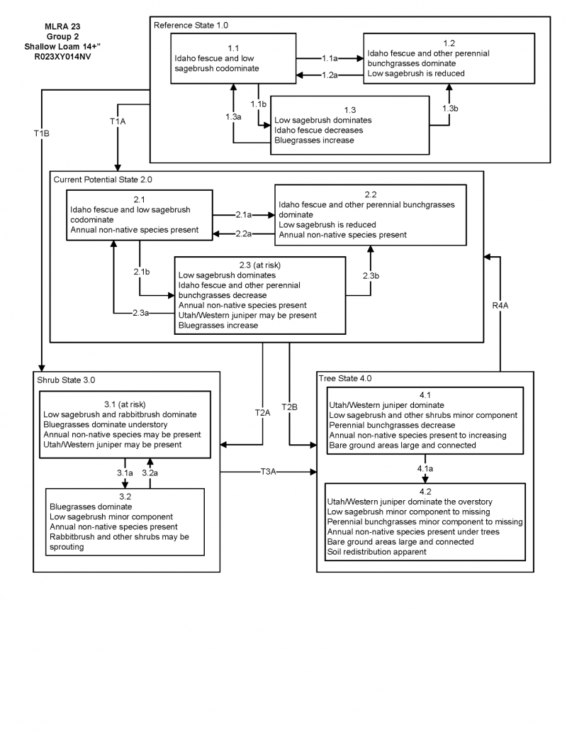
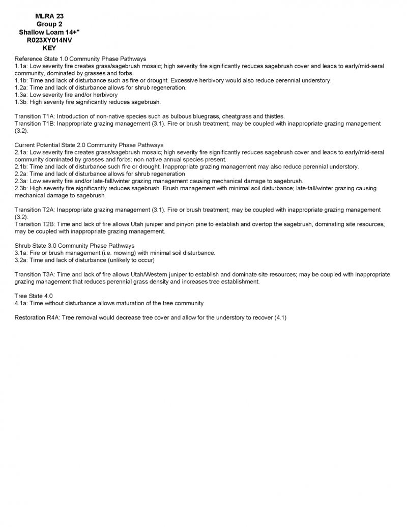
Click on box and path labels to scroll to the respective text.