Natural Resources
Conservation Service
Ecological site R023XY053NV
GRAVELLY NORTH SLOPE
Last updated: 4/10/2025
Accessed: 04/02/2026
General information
Provisional. A provisional ecological site description has undergone quality control and quality assurance review. It contains a working state and transition model and enough information to identify the ecological site.
Ecological site concept
Currently there is only a draft of the initial concept for this ecological site. The initial concept for this site places it within the Ashy or Loamy Skeletal Mod Deep 10-20 PZ High-Resilience Mountain Big Sagebrush and Idaho Fescue Ecological Site Group. To view the General STM and other information available for this ESG please go to https://edit.jornada.nmsu.edu/catalogs/esg/023X/R023XY906NV
This site is slightly less productive than the modal site with 1000 lbs/ac in normal years. Soils are similar to those of the group modal site, however this site is restricted to smooth to convex north-facing backslopes of mountains. Threetip sagebrush (Artemisia tripartita) is the dominant shrub. Research reports threetip sagebrush to have variable sprouting-behavior after fire (Akinsoji 1988, Bunting et al. 1987) and is unpalatable to livestock (Rosentreter 2005). Idaho fescue and Cusick’s bluegrass occur more frequently on the site than bluebunch wheatgrass. This site is similar to the group modal site with 2 stable states.
Associated sites
| R023XY007NV |
LOAMY 14-16 P.Z. |
|---|---|
| R023XY019NV |
LOAMY 16+ P.Z. |
| R023XY054NV |
STEEP NORTH SLOPE |
| R023XY064NV |
SOUTH SLOPE 16+ P.Z. |
| R023XY065NV |
LOAMY SLOPE 16+ P.Z. |
Table 1. Dominant plant species
| Tree |
Not specified |
|---|---|
| Shrub |
(1) Artemisia tripartita |
| Herbaceous |
(1) Festuca idahoensis |
Physiographic features
This site occurs on smooth to convex backslopes of plateaus and mountains on northerly aspects. Slopes range from 15 to 75 percent, but slope gradients of 30 to 50 percent are typical. Elevations are about 4300 to 8000 feet.
Table 2. Representative physiographic features
| Landforms |
(1)
Mountain slope
|
|---|---|
| Elevation | 4,300 – 8,000 ft |
| Slope | 15 – 75% |
| Aspect | N |
Climatic features
The climate associated with this site is semiarid and characterized by cold, moist winters and warm, dry summers. Average annual precipitation is 12 to 18 inches. Mean annual air temperature is 38 to 45 degrees F. The average growing season is about 40 to 90 days.
Nevada’s climate is predominantly arid, with large daily ranges of temperature, infrequent severe storms, heavy snowfall in the higher mountains, and great location variations with elevation. Three basic geographical factors largely influence Nevada’s climate: continentality, latitude, and elevation. Continentality is the most important factor. The strong continental effect is expressed in the form of both dryness and large temperature variations. Nevada lies on the eastern, lee side of the Sierra Nevada Range, a massive mountain barrier that markedly influences the climate of the State. The prevailing winds are from the west, and as the warm moist air from the Pacific Ocean ascend the western slopes of the Sierra Range, the air cools, condensation occurs and most of the moisture falls as precipitation. As the air descends the eastern slope, it is warmed by compression, and very little precipitation occurs. The effects of this mountain barrier are felt not only in the West but throughout the state, with the result that the lowlands of Nevada are largely desert or steppes. The temperature regime is also affected by the blocking of the inland-moving maritime air. Nevada sheltered from maritime winds, has a continental climate with well-developed seasons and the terrain responds quickly to changes in solar heating.
Nevada lies within the mid-latitude belt of prevailing westerly winds which occur most of the year. These winds bring frequent changes in weather during the late fall, winter and spring months, when most of the precipitation occurs. To the south of the mid-latitude westerlies, lies a zone of high pressure in subtropical latitudes, with a center over the Pacific Ocean. In the summer, this high-pressure belt shifts northward over the latitudes of Nevada, blocking storms from the ocean. The resulting weather is mostly clear and dry during the summer and early fall, with scattered thundershowers. The eastern portion of the state receives significant summer thunderstorms generated from monsoonal moisture pushed up from the Gulf of California, known as the North American monsoon. The monsoon system peaks in August and by October the monsoon high over the Western U.S. begins to weaken and the precipitation retreats southward towards the tropics (NOAA 2004).
Average annual precipitation is 16 to over 20 inches. Mean annual air temperature is 41 to 44 degrees F. The average growing season is about 50 to 70 days.
Mean annual precipitaion at the Bear Creek, Nevada SNOTEL station (170501020301) is 37.69 inches.
monthly mean precipitation is:
January 3.84; February 3.75; March 4.38; April 4.9;
May 3.99; June 2.82; July .95; August 1.66;
September 1.22; October 2.12;
November 3.67; December 4.38.
Table 3. Representative climatic features
| Frost-free period (average) | 65 days |
|---|---|
| Freeze-free period (average) | |
| Precipitation total (average) | 15 in |
Figure 1. Monthly average minimum and maximum temperature
Figure 2. Annual precipitation pattern
Figure 3. Annual average temperature pattern
Influencing water features
There are no influencing water features associated with this site.
Soil features
The soils associated with this site have formed in residuum and colluvium from volcanic rock sources. These soils are moderately deep and well drained. Soil textures are medium to moderately fine throughout the profile. The available water capacity is low. Soil reaction ranges from slightly acid at the surface to neutral in the subsoil. Runoff is high and permeability is moderate. The soil series associated with this site include: Westbutte.
Table 4. Representative soil features
| Surface texture |
(1) Cobbly loam (2) Stony loam (3) Very stony loam |
|---|---|
| Family particle size |
(1) Loamy |
| Drainage class | Well drained |
| Permeability class | Moderate |
| Soil depth | 20 – 40 in |
| Surface fragment cover <=3" | 13 – 21% |
| Surface fragment cover >3" | 16 – 28% |
| Available water capacity (0-40in) |
2.9 – 4 in |
| Calcium carbonate equivalent (0-40in) |
Not specified |
| Electrical conductivity (0-40in) |
Not specified |
| Sodium adsorption ratio (0-40in) |
Not specified |
| Soil reaction (1:1 water) (0-40in) |
6.6 – 7.8 |
| Subsurface fragment volume <=3" (Depth not specified) |
13 – 18% |
| Subsurface fragment volume >3" (Depth not specified) |
15 – 29% |
Ecological dynamics
Where management results in abusive use by livestock and feral horses, Idaho fescue decreases in the understory as the density of threetip sagebrush increases. At higher elevations of this site's occurance, snowberry also increases with site degradation. Wildfire on this site will increase prevalence of threetip sagebrush and snowberry on this site for a period until Idaho fescue can recover from the disturbance. Cheatgrass and thistles are plants likely to invade this site.
Fire Ecology:
Mean fire return intervals for three-tip sagebrush communities range from 25 to 40 years. Three-tip sagebrush is described as "severely damaged" by fire. Depending on intensity of fire, three-tip sagebrush may resprout. Idaho fescue grows in a dense, fine-leaved tuft. Fires tend to burn within the accumulated fine leaves at the base of the plant and may produce temperatures sufficient to kill some of the root crown. Mature Idaho fescue plants are commonly reported to be severely damaged by fire in all seasons. Cusick’s bluegrass is unharmed to slightly harmed by light-severity fall fires. Cusick’s bluegrass regenerates after fire from seed and by tillering. Burning bluebunch wheatgrass may remove most of the aboveground biomass but does not usually result in plant mortality. Bluebunch wheatgrass is generally favored by burning. Burning stimulates flowering and seed production. However, season of burning affects mortality.
State and transition model
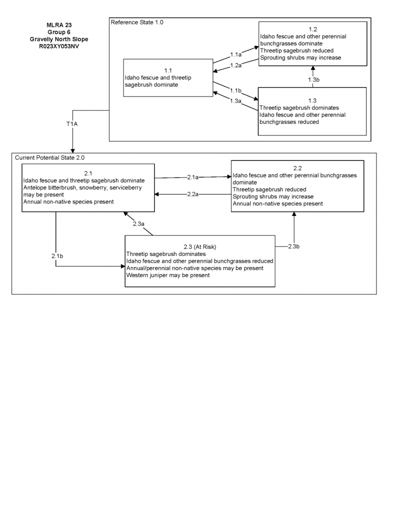

More interactive model formats are also available.
View Interactive Models
Click on state and transition labels to scroll to the respective text
Ecosystem states
State 1 submodel, plant communities
State 1
Reference Plant Community
Community 1.1
Reference Plant Community
The reference plant community is dominated by Idaho fescue and threetip sagebrush. Potential vegetative composition is about 60% grasses, 10% forbs and 30% shrubs. Approximate ground cover (basal and crown) is about 35 to 45 percent.
Figure 4. Annual production by plant type (representative values) or group (midpoint values)
Table 5. Annual production by plant type
| Plant type | Low (lb/acre) |
Representative value (lb/acre) |
High (lb/acre) |
|---|---|---|---|
| Grass/Grasslike | 480 | 600 | 720 |
| Shrub/Vine | 240 | 300 | 360 |
| Forb | 80 | 100 | 120 |
| Total | 800 | 1000 | 1200 |
Additional community tables
Table 6. Community 1.1 plant community composition
| Group | Common name | Symbol | Scientific name | Annual production (lb/acre) | Foliar cover (%) | |
|---|---|---|---|---|---|---|
|
Grass/Grasslike
|
||||||
| 1 | Primary Perennial Grasses | 470–750 | ||||
| Idaho fescue | FEID | Festuca idahoensis | 400–600 | – | ||
| Cusick's bluegrass | POCUE2 | Poa cusickii ssp. epilis | 50–100 | – | ||
| bluebunch wheatgrass | PSSPS | Pseudoroegneria spicata ssp. spicata | 20–50 | – | ||
| 2 | Secondary Perennial Grasses/Grasslikes | 20–80 | ||||
| Letterman's needlegrass | ACLE9 | Achnatherum lettermanii | 5–20 | – | ||
| Thurber's needlegrass | ACTH7 | Achnatherum thurberianum | 5–20 | – | ||
| sedge | CAREX | Carex | 5–20 | – | ||
| basin wildrye | LECI4 | Leymus cinereus | 5–20 | – | ||
|
Forb
|
||||||
| 3 | Perennial | 50–150 | ||||
| aster | ASTER | Aster | 5–30 | – | ||
| milkvetch | ASTRA | Astragalus | 5–30 | – | ||
| arrowleaf balsamroot | BASA3 | Balsamorhiza sagittata | 5–30 | – | ||
| tapertip hawksbeard | CRAC2 | Crepis acuminata | 5–30 | – | ||
| buckwheat | ERIOG | Eriogonum | 5–30 | – | ||
| lupine | LUPIN | Lupinus | 5–30 | – | ||
| phlox | PHLOX | Phlox | 5–30 | – | ||
|
Shrub/Vine
|
||||||
| 4 | Primary Shrubs | 150–250 | ||||
| threetip sagebrush | ARTR4 | Artemisia tripartita | 150–250 | – | ||
| 5 | Secondary Shrubs | 50–100 | ||||
| Utah serviceberry | AMUT | Amelanchier utahensis | 10–20 | – | ||
| mountain big sagebrush | ARTRV | Artemisia tridentata ssp. vaseyana | 10–20 | – | ||
| yellow rabbitbrush | CHVI8 | Chrysothamnus viscidiflorus | 10–20 | – | ||
| antelope bitterbrush | PUTR2 | Purshia tridentata | 10–20 | – | ||
| currant | RIBES | Ribes | 10–20 | – | ||
| snowberry | SYMPH | Symphoricarpos | 10–20 | – | ||
Interpretations
Animal community
Livestock Interpretations:
This site has limited svalue for livestock grazing due to steep slopes. Idaho fescue provides important forage for many types of domestic livestock. The foliage cures well and is preferred by livestock in late fall and winter. Cusick's bluegrass makes up only a small proportion of the biomass of the sagebrush communities in which it lives, but it is often taken preferentially by cattle, especially early in the season. Bluebunch wheatgrass is considered one of the most important forage grass species on western rangelands for livestock. Although bluebunch wheatgrass can be a crucial source of forage, it is not necessarily the most highly preferred species. Threetip sagebrush may provide some browse for domestic sheep but its value to cattle appears limited. It is not used by cattle in Nevada.
Stocking rates vary over time depending upon season of use, climate variations, site, and previous and current management goals. A safe starting stocking rate is an estimated stocking rate that is fine tuned by the client by adaptive management through the year and from year to year.
Wildlife Interpretations:
Threetip sagebrush is not a preferred browse for most wild ungulates. Threetip sagebrush is used to some extent by mule deer in both summer and winter. Elk do not generally feed on threetip sagebrush. Sagebrush-grassland communities provide critical sage-grouse breeding and nesting habitats. Meadows surrounded by sagebrush may be used as feeding and strutting grounds. Sagebrush is a crucial component of their diet year-round, and sage-grouse select sagebrush almost exclusively for cover. Sage-grouse prefer mountain big sagebrush and Wyoming big sagebrush communities to basin big sagebrush communities. Idaho fescue provides important forge for several wildlife species. It is reported to be good forage for pronghorn, and deer in ranges of northern Nevada. Deer, elk, and mountain goat also use Cusick's bluegrass early in the season. The value of Cusick's bluegrass as cover for small animals has been rated as poor to fair. Bluebunch wheatgrass is considered one of the most important forage grass species on western rangelands for wildlife. Bluebunch wheatgrass does not generally provide sufficient cover for ungulates, however, mule deer are frequently found in bluebunch-dominated grasslands.
Hydrological functions
Runoff is high. Permeability is moderate. Hydrologic soil group is C.
Recreational uses
Aesthetic value is derived from the diverse floral and faunal composition and the colorful flowering of wild flowers and shrubs during the spring and early summer. This site offers rewarding opportunities to photographers and for nature study. This site is used for hiking and has potential for upland and big game hunting.
Supporting information
Type locality
| Location 1: Humboldt County, NV | |
|---|---|
| Township/Range/Section | T45N R32E S3 |
| UTM zone | N |
| UTM northing | 385565 |
| UTM easting | 4629517 |
| Latitude | 41° 48′ 33″ |
| Longitude | 118° 22′ 39″ |
| General legal description | SW 1/4, Bilk Creek Mountains, Humboldt County, Nevada. |
| Location 2: Washoe County, NV | |
| Township/Range/Section | T44N R25E S31 |
| UTM zone | N |
| UTM northing | 319265 |
| UTM easting | 4617412 |
| Latitude | 41° 41′ 16″ |
| Longitude | 119° 10′ 18″ |
| General legal description | SW 1/4 SW 1/4, About 1 mile north of Devaney Mountain on the Sheldon Refuge, Washoe County, Nevada. |
Other references
Fire Effects Information System (Online; http://www.fs.fed.us/database/feis/plants/).
USDA-NRCS Plants Database (Online; http://www.plants.usda.gov).
Contributors
CP
T Stringham (UNR under contract with BLM)
Approval
Kendra Moseley, 4/10/2025
Rangeland health reference sheet
Interpreting Indicators of Rangeland Health is a qualitative assessment protocol used to determine ecosystem condition based on benchmark characteristics described in the Reference Sheet. A suite of 17 (or more) indicators are typically considered in an assessment. The ecological site(s) representative of an assessment location must be known prior to applying the protocol and must be verified based on soils and climate. Current plant community cannot be used to identify the ecological site.
| Author(s)/participant(s) | PATTI NOVAK-ECHENIQUE |
|---|---|
| Contact for lead author | State Rangeland Management Specialist |
| Date | 04/07/2014 |
| Approved by | Kendra Moseley |
| Approval date | |
| Composition (Indicators 10 and 12) based on | Annual Production |
Indicators
-
Number and extent of rills:
Rills are none to rare. Rock fragments armor the soil surface. -
Presence of water flow patterns:
Water flow patterns are none to rare. A few can be expected on steeper slopes in areas subject to summer convection storms or rapid snowmelt. Patterns are short (<1 m) and stable. -
Number and height of erosional pedestals or terracettes:
Pedestals are none to rare. Occurrence is usually limited to areas of water flow patterns. -
Bare ground from Ecological Site Description or other studies (rock, litter, lichen, moss, plant canopy are not bare ground):
Bare ground is ± 10-20%. Rock fragments up to 60%. -
Number of gullies and erosion associated with gullies:
Gullies are none. Natural drainages are well vegetated and stable. -
Extent of wind scoured, blowouts and/or depositional areas:
None -
Amount of litter movement (describe size and distance expected to travel):
Fine litter (foliage from grasses and annual & perennial forbs) expected to move distance of slope length during intense summer convection storms or rapid snowmelt events. Persistent litter (large woody material) will remain in place except during large rainfall events. -
Soil surface (top few mm) resistance to erosion (stability values are averages - most sites will show a range of values):
Soil stability values should be 4 to 6 on most soil textures found on this site. -
Soil surface structure and SOM content (include type of structure and A-horizon color and thickness):
Surface structure is typically fine granular. Soil surface colors are dark grayish browns and soils are typified by a mollic epipedon. Organic matter of the surface 2 to 3 inches is typically 1 to 3 percent dropping off quickly below. Organic matter content can be more or less depending on micro-topography. -
Effect of community phase composition (relative proportion of different functional groups) and spatial distribution on infiltration and runoff:
Perennial herbaceous plants (i.e., Idaho fescue) slow runoff and increase infiltration. Shrub canopy and associated litter break raindrop impact and provide opportunity for snow catch and accumulation on site. -
Presence and thickness of compaction layer (usually none; describe soil profile features which may be mistaken for compaction on this site):
Compacted layers are none. Subangular blocky sub-surface horizons are not to be interpreted as compacted layers. -
Functional/Structural Groups (list in order of descending dominance by above-ground annual-production or live foliar cover using symbols: >>, >, = to indicate much greater than, greater than, and equal to):
Dominant:
Deep-rooted, cool season, perennial bunchgrasses (Idaho fescue)Sub-dominant:
evergreen shrubs (i.e., threetip sagebrush) > shallow-rooted, cool season, perennial bunchgrasses > associated shrubs > deep-rooted, cool season, perennial forbs > fibrous, shallow-rooted, cool season, perennial and annual forbs.Other:
Additional:
-
Amount of plant mortality and decadence (include which functional groups are expected to show mortality or decadence):
Dead branches within individual shrubs common and standing dead shrub canopy material may be as much as 25% of total woody canopy; some of the mature bunchgrasses (<20%) have dead centers. -
Average percent litter cover (%) and depth ( in):
Within plant interspaces (± 20%) and depth of litter is <½ inch. -
Expected annual annual-production (this is TOTAL above-ground annual-production, not just forage annual-production):
For normal or average growing season (thru June) ± 1000 lbs/ac; Favorable years: 1200 lbs/ac; Unfavorable years: 800 lbs/ac -
Potential invasive (including noxious) species (native and non-native). List species which BOTH characterize degraded states and have the potential to become a dominant or co-dominant species on the ecological site if their future establishment and growth is not actively controlled by management interventions. Species that become dominant for only one to several years (e.g., short-term response to drought or wildfire) are not invasive plants. Note that unlike other indicators, we are describing what is NOT expected in the reference state for the ecological site:
Potential invaders include thistles, annual mustards, and cheatgrass. -
Perennial plant reproductive capability:
All functional groups should reproduce in average (or normal) and above average growing season years. Reduced growth and reproduction occur during drought years.
Print Options
Sections
Font
Other
The Ecosystem Dynamics Interpretive Tool is an information system framework developed by the USDA-ARS Jornada Experimental Range, USDA Natural Resources Conservation Service, and New Mexico State University.
Click on box and path labels to scroll to the respective text.