Natural Resources
Conservation Service
Ecological site R023XY065NV
LOAMY SLOPE 16+ P.Z.
Last updated: 4/10/2025
Accessed: 04/02/2026
General information
Provisional. A provisional ecological site description has undergone quality control and quality assurance review. It contains a working state and transition model and enough information to identify the ecological site.
Ecological site concept
Currently there is only a draft of the initial concept for this ecological site. The initial concept for this site places it within the Loamy 14-18 PZ Mountain Big Sagebrush and Mountain Brome Ecological Site Group. To view the General STM and other information available for this ESG please go to https://edit.jornada.nmsu.edu/catalogs/esg/023X/R023XY908NV
This site is less productive than the modal site at 1500 lbs/ac in normal years and is found in elevations between 6500 and 7500 ft. The plant community is dominated by mountain big sagebrush, mountain brome, needlegrasses and Idaho fescue. The soils on this site are from residuum and colluvium derived from volcanic or mixed rocks. The soils are moderately deep and well drained. Available water capacity is moderate to high. The surface layer is moderately coarse to medium textured and is 12 inches or more in thickness to the subsoil or underlying material. Subsoils are moderately coarse to moderately fine textured and may be slightly acidic. Some soils are very gravelly throughout. This site provides a cool, moist environment for plant growth because of the elevations and steep, relatively cool, aspects where it occurs. Runoff from this site is medium and the potential for sheet and rill erosion is moderate to high depending on slope. This site can be invaded by pinyon and juniper where it occurs near these woodlands. This site does not have an annual state, but has been seen with Phase II Western and/or Utah juniper so it does have a tree state. This site is a 4-state model.
Associated sites
| R023XY007NV |
LOAMY 14-16 P.Z. |
|---|---|
| R023XY019NV |
LOAMY 16+ P.Z. |
| R023XY054NV |
STEEP NORTH SLOPE |
| R023XY064NV |
SOUTH SLOPE 16+ P.Z. |
Similar sites
| R023XY019NV |
LOAMY 16+ P.Z. More productive site; typically occurs in concave positions |
|---|---|
| R023XY066NV |
ASHY LOAM 14-16 P.Z. PUTR2 codominant shrub: FEID-ACHNA codominant grasses |
| R023XY064NV |
SOUTH SLOPE 16+ P.Z. PSSPS-BRMA4-LECI4 codominant grasses |
| R023XY094NV |
ASHY SLOPE 12-14 P.Z. FEID dominant grass |
| R023XY048NV |
GRANITIC SLOPE 16+ P.Z. Shallow soils; granitic parent materials; LECI4 codominant grass |
Table 1. Dominant plant species
| Tree |
Not specified |
|---|---|
| Shrub |
(1) Artemisia tridentata ssp. vaseyana |
| Herbaceous |
(1) Bromus marginatus |
Physiographic features
This site occurs on straight to convex backslopes of high plateaus and mountains. Slopes range from 4 to 50 percent, but slope gradients of 8 to 30 percent are most typical. Elevations are 5500 to 8500 feet.
Table 2. Representative physiographic features
| Landforms |
(1)
Mountain
(2) Plateau |
|---|---|
| Elevation | 5,500 – 8,500 ft |
| Slope | 4 – 50% |
| Aspect | Aspect is not a significant factor |
Climatic features
The climate associated with this site is semiarid and characterized by cold, moist winters and cool, dry summers. Average annual precipitation is 16 to over 20 inches. Mean annual air temperature is 35 to 45 degrees F. The average growing season is about 45 to 70 days.
Nevada’s climate is predominantly arid, with large daily ranges of temperature, infrequent severe storms, heavy snowfall in the higher mountains, and great location variations with elevation. Three basic geographical factors largely influence Nevada’s climate: continentality, latitude, and elevation. Continentality is the most important factor. The strong continental effect is expressed in the form of both dryness and large temperature variations. Nevada lies on the eastern, lee side of the Sierra Nevada Range, a massive mountain barrier that markedly influences the climate of the State. The prevailing winds are from the west, and as the warm moist air from the Pacific Ocean ascend the western slopes of the Sierra Range, the air cools, condensation occurs and most of the moisture falls as precipitation. As the air descends the eastern slope, it is warmed by compression, and very little precipitation occurs. The effects of this mountain barrier are felt not only in the West but throughout the state, with the result that the lowlands of Nevada are largely desert or steppes. The temperature regime is also affected by the blocking of the inland-moving maritime air. Nevada sheltered from maritime winds, has a continental climate with well-developed seasons and the terrain responds quickly to changes in solar heating.
Nevada lies within the mid-latitude belt of prevailing westerly winds which occur most of the year. These winds bring frequent changes in weather during the late fall, winter and spring months, when most of the precipitation occurs. To the south of the mid-latitude westerlies, lies a zone of high pressure in subtropical latitudes, with a center over the Pacific Ocean. In the summer, this high-pressure belt shifts northward over the latitudes of Nevada, blocking storms from the ocean. The resulting weather is mostly clear and dry during the summer and early fall, with scattered thundershowers. The eastern portion of the state receives significant summer thunderstorms generated from monsoonal moisture pushed up from the Gulf of California, known as the North American monsoon. The monsoon system peaks in August and by October the monsoon high over the Western U.S. begins to weaken and the precipitation retreats southward towards the tropics (NOAA 2004).
Average annual precipitation is 16 to over 20 inches. Mean annual air temperature is 41 to 44 degrees F. The average growing season is about 50 to 70 days.
Mean annual precipitaion at the Bear Creek, Nevada SNOTEL station (170501020301) is 37.69 inches.
monthly mean precipitation is:
January 3.84; February 3.75; March 4.38; April 4.9;
May 3.99; June 2.82; July .95; August 1.66;
September 1.22; October 2.12;
November 3.67; December 4.38.
Table 3. Representative climatic features
| Frost-free period (average) | 57 days |
|---|---|
| Freeze-free period (average) | |
| Precipitation total (average) | 18 in |
Figure 1. Monthly average minimum and maximum temperature
Figure 2. Annual precipitation pattern
Figure 3. Annual average temperature pattern
Influencing water features
There are no influencing water features associated with this site.
Soil features
The soils associated with this site are from residuum and colluvium derived from volcanic or mixed rocks. The soils are moderately deep to very deep and well drained. Available water capacity is moderate to high. The surface layer is moderately coarse to medium textured and is 12 inches or more in thickness to the subsoil or underlying material. Subsoils are moderately coarse to moderately fine textured. These soils have a mollic epipedon. Some soils are very gravelly throughout. This site provides a cool, moist environment for plant growth because of the elevations and steep, relatively cool, aspects where it occurs. Runoff from this site is medium to very high and the potential for sheet and rill erosion is moderate to high depending on slope. The soil series associated with this site include: Hapgood, Harcany, Newlands, and Tusel.
Table 4. Representative soil features
| Surface texture |
(1) Very gravelly loam (2) Gravelly silt loam (3) Gravelly loam |
|---|---|
| Family particle size |
(1) Loamy |
| Drainage class | Well drained |
| Permeability class | Moderately slow to moderate |
| Soil depth | 40 – 84 in |
| Surface fragment cover <=3" | 15 – 41% |
| Surface fragment cover >3" | 7% |
| Available water capacity (0-40in) |
3.5 – 6.5 in |
| Calcium carbonate equivalent (0-40in) |
Not specified |
| Electrical conductivity (0-40in) |
Not specified |
| Sodium adsorption ratio (0-40in) |
Not specified |
| Soil reaction (1:1 water) (0-40in) |
6.1 – 7.3 |
| Subsurface fragment volume <=3" (Depth not specified) |
9 – 50% |
| Subsurface fragment volume >3" (Depth not specified) |
20% |
Ecological dynamics
Where management results in abusive use by livestock and/or feral horses, platable grasses decrease as snowberry and mountain big sagebrush increase in the overstory.
Fire Ecology:
Presettlement fire return intervals in mountain big sagebrush communities varied from 15 to 25 years. Mountain big sagebrush is highly susceptible to injury from fire. It is often top-killed by fire and will not resprout. Fires top-kill mountain snowberry. Although plant survival may be variable, mountain snowberry root crowns usually survive even severe fires. Mountain snowberry sprouts from basal buds at the root crown following fire. Mountain brome is likely to be top-killed by fire, although the coarse stems and broad leaves may be more fire-resistant than fine-leaved bunchgrasses. Mountain brome is most susceptible to fire damage when it is actively growing in spring and early summer. Little specific information is available on adaptations of Letterman's needlegrass to fire. It is morphologically similar to Columbia needlegrass, which is only slightly to moderately damaged by fire. Season of burn affects the plant's ability to survive a fire. Post-fire regeneration is through seeding and tillering. Columbia needlegrass is only slightly to moderately damaged by fire, because it has relatively few culms per clump which may help to minimize the amount of subsurface heat transfer and subsequent damage. Western needlegrass is moderately damaged by fire. The recovery time is between 3 and 5 years. Idaho fescue grows in a dense, fine-leaved tuft. Fires tend to burn within the accumulated fine leaves at the base of the plant and may produce temperatures sufficient to kill some of the root crown. Mature Idaho fescue plants are commonly reported to be severely damaged by fire in all seasons. The effects of fire on slender wheatgrass are dependent on its growth form. Tall, decadent plants with many leaves sustain the most fire damage, while those with short, sparse growth form, is the least likely to sustain damage to the root system during a fire. Purple oniongrass has a high fire tolerance due to the rhizomatous growth. Nevada bluegrass is generally unharmed by fire. It produces little litter, and its small bunch size and sparse litter reduces the amount of heat transferred to perennating buds in the soil.
State and transition model
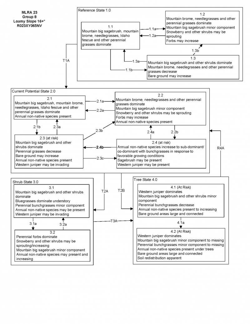

More interactive model formats are also available.
View Interactive Models
Click on state and transition labels to scroll to the respective text
Ecosystem states
State 1 submodel, plant communities
State 1
Reference Plant Community
Community 1.1
Reference Plant Community
The reference plant community is dominated by mountain big sagebrush, mountain brome, needlegrasses and Idaho fescue. Potential vegetative composition is about 50% grasses, 20% forbs and 30% shrubs. Approximate ground cover (basal and crown) is about 40 to 60 percent.
Figure 4. Annual production by plant type (representative values) or group (midpoint values)
Table 5. Annual production by plant type
| Plant type | Low (lb/acre) |
Representative value (lb/acre) |
High (lb/acre) |
|---|---|---|---|
| Grass/Grasslike | 550 | 750 | 900 |
| Shrub/Vine | 330 | 450 | 540 |
| Forb | 220 | 300 | 360 |
| Total | 1100 | 1500 | 1800 |
Additional community tables
Table 6. Community 1.1 plant community composition
| Group | Common name | Symbol | Scientific name | Annual production (lb/acre) | Foliar cover (%) | |
|---|---|---|---|---|---|---|
|
Grass/Grasslike
|
||||||
| 1 | Primary Perennial Grasses | 540–1170 | ||||
| Idaho fescue | FEID | Festuca idahoensis | 150–300 | – | ||
| mountain brome | BRMA4 | Bromus marginatus | 150–300 | – | ||
| slender wheatgrass | ELTRT | Elymus trachycaulus ssp. trachycaulus | 30–120 | – | ||
| Letterman's needlegrass | ACLE9 | Achnatherum lettermanii | 50–100 | – | ||
| Columbia needlegrass | ACNEN2 | Achnatherum nelsonii ssp. nelsonii | 50–100 | – | ||
| western needlegrass | ACOCO | Achnatherum occidentale ssp. occidentale | 50–100 | – | ||
| purple oniongrass | MESP | Melica spectabilis | 30–75 | – | ||
| 2 | Secondary Perennial Grasses/Grasslikes | 75–225 | ||||
| Thurber's needlegrass | ACTH7 | Achnatherum thurberianum | 8–75 | – | ||
| sedge | CAREX | Carex | 8–75 | – | ||
| blue wildrye | ELGL | Elymus glaucus | 8–75 | – | ||
| big squirreltail | ELMU3 | Elymus multisetus | 8–75 | – | ||
| basin wildrye | LECI4 | Leymus cinereus | 8–75 | – | ||
| bluegrass | POA | Poa | 8–75 | – | ||
| bluebunch wheatgrass | PSSPS | Pseudoroegneria spicata ssp. spicata | 8–75 | – | ||
|
Forb
|
||||||
| 3 | Perennial | 150–375 | ||||
| yarrow | ACHIL | Achillea | 8–45 | – | ||
| nettleleaf giant hyssop | AGUR | Agastache urticifolia | 8–45 | – | ||
| arrowleaf balsamroot | BASA3 | Balsamorhiza sagittata | 8–45 | – | ||
| tapertip hawksbeard | CRAC2 | Crepis acuminata | 8–45 | – | ||
| larkspur | DELPH | Delphinium | 8–45 | – | ||
| geranium | GERAN | Geranium | 8–45 | – | ||
| helianthella | HELIA | Helianthella | 8–45 | – | ||
| carrotleaf biscuitroot | LODIM | Lomatium dissectum var. multifidum | 8–45 | – | ||
| lupine | LUPIN | Lupinus | 8–45 | – | ||
| ragwort | SENEC | Senecio | 8–45 | – | ||
| clover | TRIFO | Trifolium | 8–45 | – | ||
|
Shrub/Vine
|
||||||
| 4 | Primary Shrubs | 180–420 | ||||
| mountain big sagebrush | ARTRV | Artemisia tridentata ssp. vaseyana | 150–300 | – | ||
| mountain snowberry | SYOR2 | Symphoricarpos oreophilus | 30–120 | – | ||
| 5 | Secondary Shrubs | 30–150 | ||||
| Utah serviceberry | AMUT | Amelanchier utahensis | 15–75 | – | ||
| yellow rabbitbrush | CHVIL4 | Chrysothamnus viscidiflorus ssp. lanceolatus | 15–75 | – | ||
| creeping barberry | MARE11 | Mahonia repens | 15–75 | – | ||
| quaking aspen | POTR5 | Populus tremuloides | 15–75 | – | ||
| chokecherry | PRVI | Prunus virginiana | 15–75 | – | ||
| antelope bitterbrush | PUTR2 | Purshia tridentata | 15–75 | – | ||
| currant | RIBES | Ribes | 15–75 | – | ||
| elderberry | SAMBU | Sambucus | 15–75 | – | ||
Interpretations
Animal community
Livestock Interpretations:
This site is suitable for livestock grazing. Grazing management should be keyed to perennial grass production. Mountain brome is one of the most important forage grasses in the quaking aspen zone. Mountain brome is ranked as excellent forage for both cattle and horses and good for domestic sheep. Domestic sheep will graze mountain brome only when it is fairly succulent. Letterman’s needlegrass begins growth early in the year and remains green throughout the relatively long growing season, thus, making it valuable forage for livestock. Columbia needlegrass provides valuable forage for all classes of livestock. Overall production is generally low in the upper sagebrush and mountain brush zones and at the limits of its range where Columbia needlegrass grows only in scattered patches. It is especially valuable to cattle and horses on summer ranges and to domestic sheep on lambing grounds. It is more often cropped closely by cattle and horses than by sheep. Columbia needlegrass is palatable to livestock throughout its range. As with most needlegrasses, it is most palatable early in the season before the foliage becomes coarse and wiry. Palatability to cows and horses is increased because large amounts of fine leafage remain green throughout the growing season. Palatability of Columbia needlegrass is described as fair to good for cattle and horses, becoming nearly unpalatable at maturity. Western needlegrass has a spreading and deeply penetrating root system, which makes it resistant to trampling. Idaho fescue provides important forage for many types of domestic livestock. The foliage cures well and is preferred by livestock in late fall and winter. Slender wheatgrass is grazed by all classes of livestock. Palatability for purple oniongrass is high for grazers and medium for browsers. Nevada bluegrass is a widespread forage grass. It is one of the earliest grasses in the spring and is sought by domestic livestock and several wildlife species. Nevada bluegrass is a palatable species, but its production is closely tied to weather conditions. It produces little forage in drought years, making it a less dependable food source than other perennial bunchgrasses. Mountain big sagebrush is eaten by domestic livestock but has long been considered to be of low palatability, and a competitor to more desirable species. Snowberry is readily eaten by all classes of livestock, particularly domestic sheep.
Stocking rates vary over time depending upon season of use, climate variations, site, and previous and current management goals. A safe starting stocking rate is an estimated stocking rate that is fine tuned by the client by adaptive management through the year and from year to year.
Wildlife Interpretations:
Mountain big sagebrush is highly preferred and nutritious winter forage for mule deer and elk. Sagebrush-grassland communities provide critical sage-grouse breeding and nesting habitats. Meadows surrounded by sagebrush may be used as feeding and strutting grounds. Sagebrush is a crucial component of their diet year-round, and sage-grouse select sagebrush almost exclusively for cover. Sage-grouse prefer mountain big sagebrush and Wyoming big sagebrush communities to basin big sagebrush communities. Snowberry is an important forage species for deer and elk on high elevation summer ranges. Snowberry is frequently one of the first species to leaf out, making it a highly sought after food in the early spring. Mountain brome seedheads and seeds provide food for many birds and small mammals. Pronghorn antelope will consume mountain brome primarily in the spring. The palatability of mountain brome is excellent for deer, particularly during the late spring and early summer. Letterman's needlegrass provides valuable forage for many species of wildlife. It is consumed by mule deer and is most palatable early in the season before the foliage becomes coarse and wiry. Columbia needlegrass provides valuable forage for many species of wildlife. It is also consumed by mule deer and other wildlife species throughout the growing season. Needlegrasses are a significant component in the diet of pocket gophers. Columbia needlegrass is palatable to many species of wildlife throughout its range. As with most needlegrasses, it is most palatable early in the season before the foliage becomes coarse and wiry. Palatability of Columbia needlegrass is described as fair for wildlife overall, becoming nearly unpalatable at maturity. Western needlegrass provides valuable forage for many species of wildlife. Idaho fescue provides important forge for several wildlife species. It is reported to be good forage for pronghorn, and deer in ranges of northern Nevada. Slender wheatgrass is grazed by sage grouse, deer, elk, moose, and bighorn sheep, mountain goat, pronghorn, various rodents, and all classes of livestock. The seeds are eaten by various seed predators. Slender wheatgrass provides hiding and thermal cover for songbirds, upland game birds, waterfowl, and small mammals. Purple oniongrass is an important forage species for many wildlife species. Nevada bluegrass is desirable for pronghorn antelope and mule deer in the spring and preferable in the spring, summer, and fall for elk and desirable as part of their winter range.
Hydrological functions
Runoff is medium to very high. Permeability is moderately slow to moderate. Hydrologic soil group is B and C. There are typically no rills. There may be a few, widely spaced and shallow, rills on steeper slopes (over 30% gradient). Water flow patterns are typically non-existent but can rarely occur on steeper slopes (over 30% gradient) in areas recently subjected to intense summer convection storms or rapid snowmelt. Pedestals are non-existent. Frost heaving of shallow rooted plants should not be considered a "normal" condition. Gullies are non-existent. Perennial herbaceous plants (especially deep-rooted bunchgrasses [i.e., bluebunch wheatgrass] slow runoff and increase infiltration. Shrub canopy and associated litter break raindrop impact and provide opportunity for snow catch and accumulation on site.
Recreational uses
Aesthetic value is derived from the diverse floral and faunal composition and the colorful flowering of wild flowers and shrubs during the spring and early summer. This site offers rewarding opportunities to photographers and for nature study. This site is used for camping and hiking and has potential for upland and big game hunting.
Other products
Native Americans used big sagebrush leaves and branches for medicinal teas, and the leaves as a fumigant. Bark was woven into mats, bags and clothing.
Other information
Mountain snowberry is useful for establishing cover on bare sites and has done well when planted onto roadbanks. Mountain brome is an excellent native bunchgrass for seeding alone or in mixtures in disturbed areas, including depleted rangelands, burned areas, roadways, mined lands, and degraded riparian zones. Letterman’s needlegrass has been used successfully in revegetating mine spoils. This species also has good potential for erosion control. Slender wheatgrass is widely used for revegetating disturbed lands. Slender wheatgrass is a short-lived perennial with good seedling vigor. It germinates and establishes quickly when seeded making it a good choice for quick cover on disturbed sites. It persists long enough for other, slower developing species to establish. It is especially valuable for use in saline soils. It has been used for rehabilitating mine spoils, livestock ranges, and wildlife habitat and watershed areas.
Supporting information
Type locality
| Location 1: Storey County, NV | |
|---|---|
| Township/Range/Section | T46N R19E S9 |
| UTM zone | N |
| UTM northing | 262856 |
| UTM easting | 4645166 |
| Latitude | 41° 55′ 22″ |
| Longitude | 119° 51′ 35″ |
| General legal description | NW 1/4 SW 1/4, About 7 miles east of of NV-CA stateline on Barrel Springs Road, south of road at cattle guard, Washoe County, Nevada. This site also occurs in Humboldt County, Nevada. |
Other references
Fire Effects Information System (Online; http://www.fs.fed.us/database/feis/plants/).
USDA-NRCS Plants Database (Online; http://www.plants.usda.gov).
Great Basin Ecological Site Development Project: State and Transition Models for Major Land Resource Area 23, Nevada and portions of California (Online; https://naes.agnt.unr.edu/PMS/Pubs/2019-4060.pdf)
Contributors
CP/GKB
T Stringham (UNR under contract with BLM)
Approval
Kendra Moseley, 4/10/2025
Rangeland health reference sheet
Interpreting Indicators of Rangeland Health is a qualitative assessment protocol used to determine ecosystem condition based on benchmark characteristics described in the Reference Sheet. A suite of 17 (or more) indicators are typically considered in an assessment. The ecological site(s) representative of an assessment location must be known prior to applying the protocol and must be verified based on soils and climate. Current plant community cannot be used to identify the ecological site.
| Author(s)/participant(s) | GK BRACKLEY |
|---|---|
| Contact for lead author | State Rangeland Management Specialist |
| Date | 06/20/2006 |
| Approved by | Kendra Moseley |
| Approval date | |
| Composition (Indicators 10 and 12) based on | Annual Production |
Indicators
-
Number and extent of rills:
Typically None. There may be a few, widely spaced and shallow, rills on steeper slopes (over 30% gradient). -
Presence of water flow patterns:
Water flow patterns are typically non-existent but can rarely occur on steeper slopes (over 30% gradient) in areas recently subjected to intense summer convection storms or rapid snowmelt. -
Number and height of erosional pedestals or terracettes:
Pedestals are non-existent. Frost heaving of shallow rooted plants should not be considered a "normal" condition. -
Bare ground from Ecological Site Description or other studies (rock, litter, lichen, moss, plant canopy are not bare ground):
Bare ground ± 20%; surface rock fragments less than 35%; shrub canopy 15 to 25%; foliar cover of perennial herbaceous plants ± 70%. -
Number of gullies and erosion associated with gullies:
Gullies are non-existent. -
Extent of wind scoured, blowouts and/or depositional areas:
None -
Amount of litter movement (describe size and distance expected to travel):
Fine litter (foliage from grasses and annual & perennial forbs) is expected to move the distance of slope length during intense summer convection storms or rapid snowmelt events. Persistent litter (large woody material) will remain in place except during catastrophic events. -
Soil surface (top few mm) resistance to erosion (stability values are averages - most sites will show a range of values):
Soil stability values should be 3 to 6 on most soil textures found on this site. (To be field tested.) -
Soil surface structure and SOM content (include type of structure and A-horizon color and thickness):
Surface structure is typically subangular blocky or granular. Soil surface colors are very dark and the soils are typified by a mollic epipedon. Organic matter of the surface 2 to 4 inches is typically more than 3 percent. Organic matter content can be more or less depending on micro-topography. -
Effect of community phase composition (relative proportion of different functional groups) and spatial distribution on infiltration and runoff:
Perennial herbaceous plants (especially deep-rooted bunchgrasses [i.e., bluebunch wheatgrass] slow runoff and increase infiltration. Shrub canopy and associated litter break raindrop impact and provide opportunity for snow catch and accumulation on site. -
Presence and thickness of compaction layer (usually none; describe soil profile features which may be mistaken for compaction on this site):
Compacted layers are not typical. Platy or massive sub-surface horizons and subsoil argillic horizons shallow to the surface are not to be interpreted as compacted layers. -
Functional/Structural Groups (list in order of descending dominance by above-ground annual-production or live foliar cover using symbols: >>, >, = to indicate much greater than, greater than, and equal to):
Dominant:
Reference Plant Community: Deep-rooted, cool season, perennial bunchgrasses >> tall shrubs (mountain big sagebrush) = deep-rooted, cool season, perennial forbs. (By above ground production)Sub-dominant:
Associated shrubs (mountain browse species) = fibrous, shallow-rooted, cool season, perennial and annual forbs > shallow-rooted, cool season, perennial grasses and grass-like plants. (By above ground production)Other:
Additional:
-
Amount of plant mortality and decadence (include which functional groups are expected to show mortality or decadence):
Dead branches within individual shrubs are not uncommon and standing dead shrub canopy material may be as much as 15% of total woody canopy; some of the mature bunchgrasses (<10%) have dead centers. -
Average percent litter cover (%) and depth ( in):
Between plant interspaces (± 50%) and litter depth is ± ½ inch. -
Expected annual annual-production (this is TOTAL above-ground annual-production, not just forage annual-production):
For normal or average growing season (through June) ± 1500 lbs/ac; Spring moisture significantly affects total production. -
Potential invasive (including noxious) species (native and non-native). List species which BOTH characterize degraded states and have the potential to become a dominant or co-dominant species on the ecological site if their future establishment and growth is not actively controlled by management interventions. Species that become dominant for only one to several years (e.g., short-term response to drought or wildfire) are not invasive plants. Note that unlike other indicators, we are describing what is NOT expected in the reference state for the ecological site:
Cheatgrass, thistles, and western juniper are invaders on this site. Rabbitbrush spp. is an increaser on this site. (snowberry is an aggressive increaser plant following wildfire) -
Perennial plant reproductive capability:
All functional groups should reproduce in average (or normal) and above average growing season years.
Print Options
Sections
Font
Other
The Ecosystem Dynamics Interpretive Tool is an information system framework developed by the USDA-ARS Jornada Experimental Range, USDA Natural Resources Conservation Service, and New Mexico State University.
Click on box and path labels to scroll to the respective text.