
Natural Resources
Conservation Service
Ecological site R023XY054NV
STEEP NORTH SLOPE
Last updated: 4/10/2025
Accessed: 04/17/2025
General information
Provisional. A provisional ecological site description has undergone quality control and quality assurance review. It contains a working state and transition model and enough information to identify the ecological site.
Ecological site concept
Currently there is only a draft of the initial concept for this ecological site. The initial concept for this site places it within the Ashy or Loamy Skeletal Mod Deep 10-20 PZ High-Resilience Mountain Big Sagebrush and Idaho Fescue Ecological Site Group. To view the General STM and other information available for this ESG please go to https://edit.jornada.nmsu.edu/catalogs/esg/023X/R023XY906NV
This site has similar productivity and soils to the modal site but occurs on northern-aspect slopes that typically range from 30 to 50 percent with precipitation up to 18 inches annually. Idaho fescue and Cusick’s bluegrass occur more frequently on the site than bluebunch wheatgrass. This site is similar to the group modal site with 2 stable states.
Associated sites
R023XY007NV |
LOAMY 14-16 P.Z. |
---|---|
R023XY016NV |
SOUTH SLOPE 12-16 P.Z. |
R023XY019NV |
LOAMY 16+ P.Z. |
R023XY064NV |
SOUTH SLOPE 16+ P.Z. |
R023XY065NV |
LOAMY SLOPE 16+ P.Z. |
Similar sites
R023XY061NV |
MOUNTAIN SHOULDERS 14-18 P.Z. more productive site; slopes typically less than 15% |
---|---|
R023XY094NV |
ASHY SLOPE 12-14 P.Z. ACHNA major grasses; soils have very high amounts of volcanic ash |
R023XY007NV |
LOAMY 14-16 P.Z. PSSPS codominant grass |
R023XY043NV |
GRANITIC SLOPE 14-16 P.Z. PSSPS codominant grass; soils derived from granitic parent material |
R023XY053NV |
GRAVELLY NORTH SLOPE ARTR4 dominant shrub |
R023XY084NV |
DEEP LOAMY 14-16 P.Z. more productive site; ACHNA major grasses; slopes less than 30% |
Table 1. Dominant plant species
Tree |
Not specified |
---|---|
Shrub |
(1) Artemisia tridentata var. vaseyana |
Herbaceous |
(1) Festuca idahoensis |
Physiographic features
This site occurs on steep to very steep, straight to slightly concave, backslopes of plateaus and mountains. This plant community is restricted to northerly-facing aspects. Slopes range from 15 to 75 percent, but slope gradients of 30 to 50 percent are typical. Elevations are 5400 to about 10400 feet.
Table 2. Representative physiographic features
Landforms |
(1)
Mountain
|
---|---|
Elevation | 5,400 – 10,400 ft |
Slope | 15 – 75% |
Aspect | N |
Climatic features
The climate associated with this site is semiarid and characterized by cold, moist winters and warm, dry summers. Average annual precipitation is 14 to over 18 inches. Mean annual air temperature is 41 to 44 degrees F. The average growing season is about 50 to 85 days.
Nevada’s climate is predominantly arid, with large daily ranges of temperature, infrequent severe storms, heavy snowfall in the higher mountains, and great location variations with elevation. Three basic geographical factors largely influence Nevada’s climate: continentality, latitude, and elevation. Continentality is the most important factor. The strong continental effect is expressed in the form of both dryness and large temperature variations. Nevada lies on the eastern, lee side of the Sierra Nevada Range, a massive mountain barrier that markedly influences the climate of the State. The prevailing winds are from the west, and as the warm moist air from the Pacific Ocean ascend the western slopes of the Sierra Range, the air cools, condensation occurs and most of the moisture falls as precipitation. As the air descends the eastern slope, it is warmed by compression, and very little precipitation occurs. The effects of this mountain barrier are felt not only in the West but throughout the state, with the result that the lowlands of Nevada are largely desert or steppes. The temperature regime is also affected by the blocking of the inland-moving maritime air. Nevada sheltered from maritime winds, has a continental climate with well-developed seasons and the terrain responds quickly to changes in solar heating.
Nevada lies within the mid-latitude belt of prevailing westerly winds which occur most of the year. These winds bring frequent changes in weather during the late fall, winter and spring months, when most of the precipitation occurs. To the south of the mid-latitude westerlies, lies a zone of high pressure in subtropical latitudes, with a center over the Pacific Ocean. In the summer, this high-pressure belt shifts northward over the latitudes of Nevada, blocking storms from the ocean. The resulting weather is mostly clear and dry during the summer and early fall, with scattered thundershowers. The eastern portion of the state receives significant summer thunderstorms generated from monsoonal moisture pushed up from the Gulf of California, known as the North American monsoon. The monsoon system peaks in August and by October the monsoon high over the Western U.S. begins to weaken and the precipitation retreats southward towards the tropics (NOAA 2004).
Average annual precipitation is 16 to over 20 inches. Mean annual air temperature is 41 to 44 degrees F. The average growing season is about 50 to 70 days.
Mean annual precipitaion at the Bear Creek, Nevada SNOTEL station (170501020301) is 37.69 inches.
monthly mean precipitation is:
January 3.84; February 3.75; March 4.38; April 4.9;
May 3.99; June 2.82; July .95; August 1.66;
September 1.22; October 2.12;
November 3.67; December 4.38.
Table 3. Representative climatic features
Frost-free period (average) | 67 days |
---|---|
Freeze-free period (average) | |
Precipitation total (average) | 16 in |
Figure 1. Monthly average minimum and maximum temperature
Figure 2. Annual precipitation pattern
Figure 3. Annual average temperature pattern
Influencing water features
There are no influencing water features associated with this site.
Soil features
The soils associated with this site have formed in residuum and colluvium from volcanic rock sources. These soils are deep and well drained. Surface soils are dark colored and medium to moderately fine textured. The available water capacity is high. Soil reaction ranges from slightly acid at the surface to neutral in the subsoil. Runoff is high to very high and permeability is slow to moderate. The soil series associated with this site include: Bullump, Harcany, Newlands, Thulepah, Tusune, and Westbutte.
Table 4. Representative soil features
Surface texture |
(1) Extremely stony loam (2) Gravelly loam (3) Stony loam |
---|---|
Family particle size |
(1) Loamy |
Drainage class | Well drained |
Permeability class | Slow to moderate |
Soil depth | 20 – 84 in |
Surface fragment cover <=3" | 11 – 53% |
Surface fragment cover >3" | 3 – 38% |
Available water capacity (0-40in) |
2.8 – 7.4 in |
Calcium carbonate equivalent (0-40in) |
Not specified |
Electrical conductivity (0-40in) |
Not specified |
Sodium adsorption ratio (0-40in) |
Not specified |
Soil reaction (1:1 water) (0-40in) |
6.1 – 7.8 |
Subsurface fragment volume <=3" (Depth not specified) |
12 – 39% |
Subsurface fragment volume >3" (Depth not specified) |
36% |
Ecological dynamics
Where management results in abusive grazing use by livestock and feral horses, Idaho fescue decreases in the understory as the density of big sagebrush and snowberry increases. Cheatgrass and thistles are plants likely to invade this site.
Fire Ecology:
Presettlement fire return intervals in mountain big sagebrush communities varied from 15 to 25 years. Mountain big sagebrush is highly susceptible to injury from fire. It is often top-killed by fire and will not resprout. Fires top-kill mountain snowberry. Although plant survival may be variable, mountain snowberry root crowns usually survive even severe fires. Mountain snowberry sprouts from basal buds at the root crown following fire. Antelope bitterbrush is considered a weak sprouter and is often killed by summer or fall fire. Antelope bitterbrush in some areas may sprout after light-severity spring fire. High fuel consumptions increase antelope bitterbrush mortality and therefore favors seedling establishment. Idaho fescue grows in a dense, fine-leaved tuft. Fires tend to burn within the accumulated fine leaves at the base of the plant and may produce temperatures sufficient to kill some of the root crown. Mature Idaho fescue plants are commonly reported to be severely damaged by fire in all seasons. Cusick’s bluegrass is unharmed to slightly harmed by light-severity fall fires. Cusick’s bluegrass regenerates after fire from seed and by tillering. Burning bluebunch wheatgrass may remove most of the aboveground biomass but does not usually result in plant mortality. Bluebunch wheatgrass is generally favored by burning. Burning stimulates flowering and seed production. However, season of burning affects mortality. Basin wildrye is top-killed by fire. Older basin wildrye plants with large proportions of dead material within the perennial crown can be expected to show higher mortality due to fire than younger plants having little debris. Basin wildrye is generally tolerant of fire but may be damaged by early season fire combined with dry soil conditions.
State and transition model
More interactive model formats are also available.
View Interactive Models
Click on state and transition labels to scroll to the respective text
Ecosystem states
State 1 submodel, plant communities
State 1
Reference Plant Community
Community 1.1
Reference Plant Community
The reference plant community is dominated by Idaho fescue. Mountain big sagebrush, snowberry, lupine, and Cusick's bluegrass are other important species associated with this site. Potential vegetative composition is about 70% grasses, 15% forbs and 15% shrubs. Approximate ground cover (basal and crown) is about 35 to 45 percent.
Figure 4. Annual production by plant type (representative values) or group (midpoint values)
Table 5. Annual production by plant type
Plant type | Low (lb/acre) |
Representative value (lb/acre) |
High (lb/acre) |
---|---|---|---|
Grass/Grasslike | 630 | 840 | 1050 |
Forb | 135 | 180 | 225 |
Shrub/Vine | 135 | 180 | 225 |
Total | 900 | 1200 | 1500 |
Additional community tables
Table 6. Community 1.1 plant community composition
Group | Common name | Symbol | Scientific name | Annual production (lb/acre) | Foliar cover (%) | |
---|---|---|---|---|---|---|
Grass/Grasslike
|
||||||
1 | Primary Perennial Grasses | 708–1140 | ||||
Idaho fescue | FEID | Festuca idahoensis | 600–780 | – | ||
Cusick's bluegrass | POCUE2 | Poa cusickii ssp. epilis | 60–180 | – | ||
bluebunch wheatgrass | PSSPS | Pseudoroegneria spicata ssp. spicata | 24–120 | – | ||
basin wildrye | LECI4 | Leymus cinereus | 24–60 | – | ||
2 | Secondary Perennial Grasses/Grasslikes | 24–96 | ||||
needlegrass | ACHNA | Achnatherum | 6–24 | – | ||
mountain brome | BRMA4 | Bromus marginatus | 6–24 | – | ||
sedge | CAREX | Carex | 6–24 | – | ||
Forb
|
||||||
3 | Perennial | 144–300 | ||||
lupine | LUPIN | Lupinus | 24–60 | – | ||
ragwort | SENEC | Senecio | 6–36 | – | ||
mule-ears | WYAM | Wyethia amplexicaulis | 6–36 | – | ||
giant hyssop | AGAST | Agastache | 6–36 | – | ||
arrowleaf balsamroot | BASA3 | Balsamorhiza sagittata | 6–36 | – | ||
tapertip hawksbeard | CRAC2 | Crepis acuminata | 6–36 | – | ||
tall mountain larkspur | DESC | Delphinium scaposum | 6–36 | – | ||
western stoneseed | LIRU4 | Lithospermum ruderale | 6–36 | – | ||
Shrub/Vine
|
||||||
4 | Primary Shrubs | 85–300 | ||||
mountain big sagebrush | ARTRV | Artemisia tridentata ssp. vaseyana | 60–180 | – | ||
antelope bitterbrush | PUTR2 | Purshia tridentata | 1–60 | – | ||
mountain snowberry | SYOR2 | Symphoricarpos oreophilus | 24–60 | – | ||
5 | Secondary Shrubs | 24–96 | ||||
Utah serviceberry | AMUT | Amelanchier utahensis | 12–24 | – | ||
yellow rabbitbrush | CHVI8 | Chrysothamnus viscidiflorus | 12–24 | – | ||
currant | RIBES | Ribes | 12–24 | – |
Interpretations
Animal community
Livestock Interpretations:
This site has limited value for livestock grazing due to steep slopes. Idaho fescue provides important forage for many types of domestic livestock. The foliage cures well and is preferred by livestock in late fall and winter. Cusick's bluegrass makes up only a small proportion of the biomass of the sagebrush communities in which it lives, but it is often taken preferentially by cattle, especially early in the season. Bluebunch wheatgrass is considered one of the most important forage grass species on western rangelands for livestock. Although bluebunch wheatgrass can be a crucial source of forage, it is not necessarily the most highly preferred species. The early growth and abundant production of basin wildrye make it a valuable source of forage for livestock. It is important forage for cattle and is readily grazed by cattle and horses in early spring and fall. Though coarse-textured during the winter, basin wildrye may be utilized more frequently by livestock and wildlife when snow has covered low shrubs and other grasses. Mountain big sagebrush is eaten by domestic livestock but has long been considered to be of low palatability, and a competitor to more desirable species. Snowberry is readily eaten by all classes of livestock, particularly domestic sheep. Antelope bitterbrush is important browse for livestock. Domestic livestock and mule deer may compete for antelope bitterbrush in late summer, fall, and/or winter. Cattle prefer antelope bitterbrush from mid-May through June and again in September and October.
Stocking rates vary over time depending upon season of use, climate variations, site, and previous and current management goals. A safe starting stocking rate is an estimated stocking rate that is fine tuned by the client by adaptive management through the year and from year to year.
Wildlife Interpretations:
Mountain big sagebrush is highly preferred and nutritious winter forage for mule deer and elk. Sagebrush-grassland communities provide critical sage-grouse breeding and nesting habitats. Meadows surrounded by sagebrush may be used as feeding and strutting grounds. Sagebrush is a crucial component of their diet year-round, and sage-grouse select sagebrush almost exclusively for cover. Sage-grouse prefer mountain big sagebrush and Wyoming big sagebrush communities to basin big sagebrush communities. Snowberry is an important forage species for deer and elk on high elevation summer ranges. Snowberry is frequently one of the first species to leaf out, making it a highly sought after food in the early spring. Pronghorn antelope, mule deer, elk, and bighorn sheep utilize antelope bitterbrush extensively. Mule deer use of antelope bitterbrush peaks in September, when antelope bitterbrush may compose 91 percent of the diet. Winter use is greatest during periods of deep snow. Antelope bitterbrush seed is a large part of the diets of rodents, especially deer mice and kangaroo rats. Idaho fescue provides important forge for several wildlife species. It is reported to be good forage for pronghorn, and deer in ranges of northern Nevada. Deer, elk, and mountain goat also use Cusick's bluegrass early in the season. The value of Cusick's bluegrass as cover for small animals has been rated as poor to fair. Bluebunch wheatgrass is considered one of the most important forage grass species on western rangelands for wildlife. Bluebunch wheatgrass does not generally provide sufficient cover for ungulates, however, mule deer are frequently found in bluebunch-dominated grasslands. Basin wildrye provides winter forage for mule deer, though use is often low compared to other native grasses. Basin wildrye provides summer forage for black-tailed jackrabbits. Because basin wildrye remains green throughout early summer, it remains available for small mammal forage for longer time than other grasses.
Hydrological functions
Runoff is high to very high. Permeability is slow to moderate. Hydrologic soil group is B and C. Rills are typically non-existent. Water flow patterns are rare but can be expected on steeper slopes in areas recently subjected to summer convection storms or rapid snowmelt. Pedestals are rare. Frost heaving of shallow rooted plants should not be considered a "normal" condition. Gullies are non-existent in areas of this site that occur on stable landforms. Perennial herbaceous plants (especially deep-rooted bunchgrasses [i.e., Idaho fescue] slow runoff and increase infiltration. Shrub canopy and associated litter break raindrop impact and provide opportunity for snow catch and accumulation on site.
Recreational uses
Aesthetic value is derived from the diverse floral and faunal composition and the colorful flowering of wild flowers and shrubs during the spring and early summer. This site offers rewarding opportunities to photographers and for nature study. This site is used for hiking and has potential for upland and big game hunting.
Other products
Native Americans used big sagebrush leaves and branches for medicinal teas, and the leaves as a fumigant. Bark was woven into mats, bags and clothing. Basin wildrye was used as bedding for various Native American ceremonies, providing a cool place for dancers to stand.
Other information
Mountain snowberry is useful for establishing cover on bare sites and has done well when planted onto roadbanks. Antelope bitterbrush has been used extensively in land reclamation. Antelope bitterbrush enhances succession by retaining soil and depositing organic material and in some habitats and with some ecotypes, by fixing nitrogen. Basin wildrye is useful in mine reclamation, fire rehabilitation and stabilizing disturbed areas. Its usefulness in range seeding, however, may be limited by initially weak stand establishment.
Supporting information
Type locality
Location 1: Washoe County, NV | |
---|---|
Township/Range/Section | T47N R20E S34 |
UTM zone | N |
UTM northing | 274103 |
UTM easting | 4648017 |
Latitude | 41° 57′ 6″ |
Longitude | 119° 43′ 31″ |
General legal description | SW 1/4 SW 1/4, Northeast-facing sideslopes off west side of Coleman Canyon road, Washoe County, Nevada. This site also occurs in Humboldt County, Nevada. |
Other references
Fire Effects Information System (Online; http://www.fs.fed.us/database/feis/plants/).
USDA-NRCS Plants Database (Online; http://www.plants.usda.gov).
Contributors
CP/SW
T Stringham (UNR under contract with BLM)
Approval
Kendra Moseley, 4/10/2025
Rangeland health reference sheet
Interpreting Indicators of Rangeland Health is a qualitative assessment protocol used to determine ecosystem condition based on benchmark characteristics described in the Reference Sheet. A suite of 17 (or more) indicators are typically considered in an assessment. The ecological site(s) representative of an assessment location must be known prior to applying the protocol and must be verified based on soils and climate. Current plant community cannot be used to identify the ecological site.
Author(s)/participant(s) | GK BRACKLEY |
---|---|
Contact for lead author | State Rangeland Management Specialist |
Date | 06/20/2006 |
Approved by | Kendra Moseley |
Approval date | |
Composition (Indicators 10 and 12) based on | Annual Production |
Indicators
-
Number and extent of rills:
Rills are typically non-existent. -
Presence of water flow patterns:
Water flow patterns are rare but can be expected on steeper slopes in areas recently subjected to summer convection storms or rapid snowmelt. -
Number and height of erosional pedestals or terracettes:
Pedestals are rare. Frost heaving of shallow rooted plants should not be considered a "normal" condition. -
Bare ground from Ecological Site Description or other studies (rock, litter, lichen, moss, plant canopy are not bare ground):
Bare ground ± 25%; surface rock fragments <25%; shrub canopy 15 to 30%; foliar cover of perennial herbaceous plants ± 60%. -
Number of gullies and erosion associated with gullies:
Gullies are non-existent in areas of this site that occur on stable landforms. -
Extent of wind scoured, blowouts and/or depositional areas:
None -
Amount of litter movement (describe size and distance expected to travel):
Fine litter (foliage from grasses and annual & perennial forbs) is expected to move the distance of slope length during intense summer convection storms or rapid snowmelt events. Persistent litter (large woody material) will remain in place except during catastrophic events. -
Soil surface (top few mm) resistance to erosion (stability values are averages - most sites will show a range of values):
Soil stability values should be 3 to 6 on most soil textures found on this site. (To be field tested.) -
Soil surface structure and SOM content (include type of structure and A-horizon color and thickness):
Surface structure is typically subangular blocky or granular. Soil surface colors are dark and the soils are typified by an mollic epipedon. Organic matter of the surface 2 to 4 inches is typically 1.25 to 3 percent dropping off quickly below. Organic matter content can be more or less depending on micro-topography. -
Effect of community phase composition (relative proportion of different functional groups) and spatial distribution on infiltration and runoff:
Perennial herbaceous plants (especially deep-rooted bunchgrasses [i.e., Idaho fescue] slow runoff and increase infiltration. Shrub canopy and associated litter break raindrop impact and provide opportunity for snow catch and accumulation on site. -
Presence and thickness of compaction layer (usually none; describe soil profile features which may be mistaken for compaction on this site):
Compacted layers are not typical. Platy or massive sub-surface horizons on subsoil argillic horizons shallow to the surface are not to be interpreted as compacted soil layers. -
Functional/Structural Groups (list in order of descending dominance by above-ground annual-production or live foliar cover using symbols: >>, >, = to indicate much greater than, greater than, and equal to):
Dominant:
Reference Plant Community: Deep-rooted, cool season, perennial bunchgrasses >> tall shrubs (mountain big sagebrush). (By above ground production)Sub-dominant:
Associated shrubs > shallow-rooted, cool season, perennial grasses > deep-rooted, cool season, perennial forbs > fibrous, shallow-rooted, cool season, perennial and annual forbs. (By above ground production)Other:
Additional:
-
Amount of plant mortality and decadence (include which functional groups are expected to show mortality or decadence):
Dead branches within individual shrubs are common and standing dead shrub canopy material may be as much as 20% of total woody canopy; some of the mature bunchgrasses (<10%) have dead centers. -
Average percent litter cover (%) and depth ( in):
Between plant interspaces (± 40%) and litter depth is ± ½ inch. -
Expected annual annual-production (this is TOTAL above-ground annual-production, not just forage annual-production):
For normal or average growing season (through mid-June) ± 1200 lbs/ac; Spring moisture significantly affects total production. -
Potential invasive (including noxious) species (native and non-native). List species which BOTH characterize degraded states and have the potential to become a dominant or co-dominant species on the ecological site if their future establishment and growth is not actively controlled by management interventions. Species that become dominant for only one to several years (e.g., short-term response to drought or wildfire) are not invasive plants. Note that unlike other indicators, we are describing what is NOT expected in the reference state for the ecological site:
Cheatgrass and thistle are invaders on this site. Rabbitbrush and snowberry are increasers on this site. -
Perennial plant reproductive capability:
All functional groups should reproduce in average (or normal) and above average growing season years.
Print Options
Sections
Font
Other
The Ecosystem Dynamics Interpretive Tool is an information system framework developed by the USDA-ARS Jornada Experimental Range, USDA Natural Resources Conservation Service, and New Mexico State University.
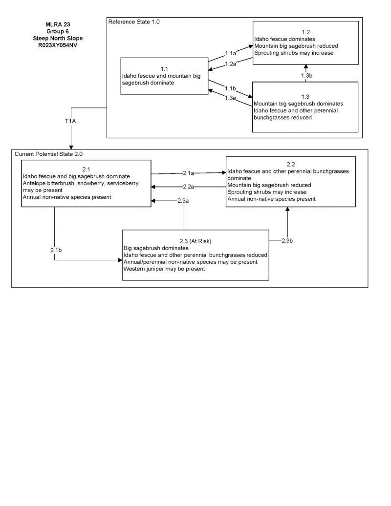
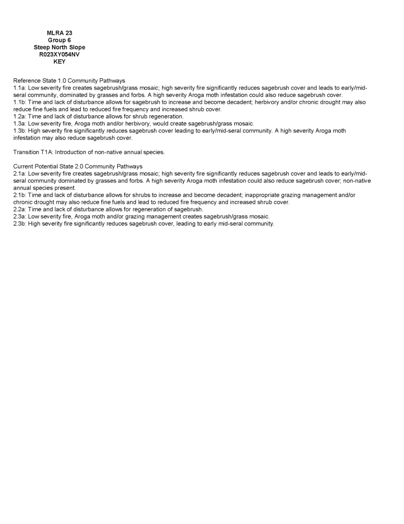
Click on box and path labels to scroll to the respective text.