
Natural Resources
Conservation Service
Ecological site R023XY069NV
GRANITIC MAHOGANY SAVANNA
Last updated: 4/10/2025
Accessed: 04/12/2025
General information
Provisional. A provisional ecological site description has undergone quality control and quality assurance review. It contains a working state and transition model and enough information to identify the ecological site.
Ecological site concept
Currently there is only a draft of the initial concept for this ecological site. The initial concept for this site places it within the Mountain Slope 16-20 PZ Mahogany Site Group. To view the General STM and other information available for this ESG please go to https://edit.jornada.nmsu.edu/catalogs/esg/023X/R023XY917NV
This site is slightly less productive than the modal site with 1800 lbs/ac total production (including mahogany) in normal years. The soils of this site are shallow, well drained and have formed in residuum from granitic rock sources. There are high amounts of boulders, stones and cobbles on the surface. The soils have rapid runoff and are moderately permeable. Sheet and rill erosion potential is low. Canopy cover of mountain mahogany is less than 45 percent. The subdominant shrubs include mountain big sagebrush and antelope bitterbrush (Purishia tridentata). The grass community is dominated by Letterman’s needlegrass (Achantherum lettermanii) and Nevada bluegrass (Poa nevadensis). During field visits, this site was seen in phase 2.4, indicating that it may be less resilient than the group modal site and may be more at risk of an annual state, however an annual states was not seen during site visits. This site has two stable states.
Associated sites
R023XY043NV |
GRANITIC SLOPE 14-16 P.Z. |
---|---|
R023XY048NV |
GRANITIC SLOPE 16+ P.Z. |
R023XY053NV |
GRAVELLY NORTH SLOPE |
R023XY073NV |
GRANITIC MAHOGANY THICKET |
Similar sites
R023XY073NV |
GRANITIC MAHOGANY THICKET less understory production; more uniform stand of CELE3; canopy cover >50% |
---|---|
R023XY026NV |
MAHOGANY SAVANNA PSSPS-FEID codominant grasses; soils derived from volcanic parent materials |
Table 1. Dominant plant species
Tree |
(1) Cercocarpus ledifolius |
---|---|
Shrub |
(1) Artemisia tridentata var. vaseyana |
Herbaceous |
(1) Poa nevadensis |
Physiographic features
This site occurs on smooth to slightly convex summits and shoulders of mountains sideslopes. Slopes range from 8 to 50 percent, but slope gradients of 30 to 50 percent are typical. Elevations are 5500 to 8500 feet.
Table 2. Representative physiographic features
Landforms |
(1)
Mountain
|
---|---|
Elevation | 5,500 – 8,500 ft |
Slope | 8 – 50% |
Aspect | Aspect is not a significant factor |
Climatic features
The climate associated with this site is semiarid and characterized by cold, moist winters and cool, dry summers. Average annual precipitation is 16 to 20 inches. Mean annual air temperature is 38 to 41 degrees F. The average growing season is about 30 to 60 days.
Nevada’s climate is predominantly arid, with large daily ranges of temperature, infrequent severe storms, heavy snowfall in the higher mountains, and great location variations with elevation. Three basic geographical factors largely influence Nevada’s climate: continentality, latitude, and elevation. Continentality is the most important factor. The strong continental effect is expressed in the form of both dryness and large temperature variations. Nevada lies on the eastern, lee side of the Sierra Nevada Range, a massive mountain barrier that markedly influences the climate of the State. The prevailing winds are from the west, and as the warm moist air from the Pacific Ocean ascend the western slopes of the Sierra Range, the air cools, condensation occurs and most of the moisture falls as precipitation. As the air descends the eastern slope, it is warmed by compression, and very little precipitation occurs. The effects of this mountain barrier are felt not only in the West but throughout the state, with the result that the lowlands of Nevada are largely desert or steppes. The temperature regime is also affected by the blocking of the inland-moving maritime air. Nevada sheltered from maritime winds, has a continental climate with well-developed seasons and the terrain responds quickly to changes in solar heating.
Nevada lies within the mid-latitude belt of prevailing westerly winds which occur most of the year. These winds bring frequent changes in weather during the late fall, winter and spring months, when most of the precipitation occurs. To the south of the mid-latitude westerlies, lies a zone of high pressure in subtropical latitudes, with a center over the Pacific Ocean. In the summer, this high-pressure belt shifts northward over the latitudes of Nevada, blocking storms from the ocean. The resulting weather is mostly clear and dry during the summer and early fall, with scattered thundershowers. The eastern portion of the state receives significant summer thunderstorms generated from monsoonal moisture pushed up from the Gulf of California, known as the North American monsoon. The monsoon system peaks in August and by October the monsoon high over the Western U.S. begins to weaken and the precipitation retreats southward towards the tropics (NOAA 2004).
Average annual precipitation is 16 to over 20 inches. Mean annual air temperature is 41 to 44 degrees F. The average growing season is about 50 to 70 days.
Mean annual precipitaion at the Bear Creek, Nevada SNOTEL station (170501020301) is 37.69 inches.
monthly mean precipitation is:
January 3.84; February 3.75; March 4.38; April 4.9;
May 3.99; June 2.82; July .95; August 1.66;
September 1.22; October 2.12;
November 3.67; December 4.38.
Table 3. Representative climatic features
Frost-free period (average) | 45 days |
---|---|
Freeze-free period (average) | |
Precipitation total (average) | 18 in |
Figure 1. Monthly average minimum and maximum temperature
Figure 2. Annual precipitation pattern
Figure 3. Annual average temperature pattern
Influencing water features
There are no influencing water features associated with this site.
Soil features
The soils associated with this site have formed in residuum from granitic rock sources. Soils are shallow to moderately deep and well drained. There are high amounts of boulders, stones and cobbles on the surface. These soils have a mollic epipedon. The soils have high to very high runoff and are moderately permeable. Sheet and rill erosion potential is low. The soils correlated to this site are classified as Lithic Argixerolls and Pachic Cryoborolls.
Table 4. Representative soil features
Surface texture |
(1) Stony loam (2) Very bouldery coarse sandy loam (3) Gravelly sandy loam |
---|---|
Family particle size |
(1) Loamy |
Drainage class | Well drained |
Permeability class | Moderate |
Soil depth | 10 – 40 in |
Surface fragment cover <=3" | 15 – 35% |
Surface fragment cover >3" | 15 – 60% |
Available water capacity (0-40in) |
0.5 – 3 in |
Calcium carbonate equivalent (0-40in) |
Not specified |
Electrical conductivity (0-40in) |
Not specified |
Sodium adsorption ratio (0-40in) |
Not specified |
Soil reaction (1:1 water) (0-40in) |
6.6 – 7.3 |
Subsurface fragment volume <=3" (Depth not specified) |
15 – 35% |
Subsurface fragment volume >3" (Depth not specified) |
15 – 35% |
Ecological dynamics
As ecological condition declines, understory grasses and forbs are eliminated and rabbitbrush and other woody plants increase. Heavy browsing by livestock or big game animals will result in the reproduction and productivity of curlleaf mountainmahogany to be adversely impacted. Species likely to invade this site are annual grasses and forbs.
Fire Ecology:
The historic fire regime of curlleaf mountainmahogany communities probably varied with community type and structure. The fire return interval is highly variable, ranging from 13 to over 100 years. Curlleaf mountain mahogany may depend on fire to reduce conifer competition and produce favorable soil conditions for seedling establishment. Some curlleaf mountainmahogany stands occupy sites with very low fuel levels that rarely burn. Individual curlleaf mountainmahogany are severely damaged by fire. Because many dead branches persist in the crown and leaves are slightly resinous, curlleaf mountainmahogany is probably very flammable. Curlleaf mountainmahogany is a weak sprouter after a fire. Mountain big sagebrush is highly susceptible to injury from fire. It is often top-killed by fire and will not resprout. Antelope bitterbrush is considered a weak sprouter and is often killed by summer or fall fire. Antelope bitterbrush in some areas may sprout after light-severity spring fire. High fuel consumptions increase antelope bitterbrush mortality and therefore favors seedling establishment. Little specific information is available on adaptations of Letterman's needlegrass to fire. It is morphologically similar to Columbia needlegrass, which is only slightly to moderately damaged by fire. Season of burn affects the plant's ability to survive a fire. Post-fire regeneration is through seeding and tillering. Nevada bluegrass is generally unharmed by fire. It produces little litter, and its small bunch size and sparse litter reduces the amount of heat transferred to perennating buds in the soil. Mountain brome is likely to be top-killed by fire, although the coarse stems and broad leaves may be more fire-resistant than fine-leaved bunchgrasses. Mountain brome is most susceptible to fire damage when it is actively growing in spring and early summer. Big squirreltail is considered to be one of the most fire resistant native bunchgrasses. Older plants contain relatively low amounts of dead material when compared with other native bunchgrasses. This allows for hot, but quick burns which do not penetrate and damage the crown. However, during dry years, plants can be damaged by severe burns.
State and transition model
More interactive model formats are also available.
View Interactive Models
Click on state and transition labels to scroll to the respective text
Ecosystem states
State 1 submodel, plant communities
State 1
Reference Plant Community
Community 1.1
Reference Plant Community
The reference plant community is dominated by curlleaf mountainmahogany. Other important species are mountain big sagebrush, antelope bitterbrush, needlegrassses, bluegrass and big squirreltail. Canopy cover of mountainmahogany is less than 45 percent. Potential vegetative composition is about 25% grasses, 10% forbs , 25% understory shrubs, and 40% tree-like shrubs. Approximate ground cover (basal and crown) is 25 to 45 percent. Total production for all vegetation in the understory to a height of 4½ feet: Unfavorable years - 600 lbs/ac, Normal years - 900 lbs/ac, Favorable years, 1300 lbs/ac.
Figure 4. Annual production by plant type (representative values) or group (midpoint values)
Table 5. Annual production by plant type
Plant type | Low (lb/acre) |
Representative value (lb/acre) |
High (lb/acre) |
---|---|---|---|
Tree | 480 | 720 | 1000 |
Shrub/Vine | 300 | 450 | 625 |
Grass/Grasslike | 300 | 450 | 625 |
Forb | 120 | 180 | 250 |
Total | 1200 | 1800 | 2500 |
Additional community tables
Table 6. Community 1.1 plant community composition
Group | Common name | Symbol | Scientific name | Annual production (lb/acre) | Foliar cover (%) | |
---|---|---|---|---|---|---|
Grass/Grasslike
|
||||||
1 | Primary Perennial Grasses | 144–540 | ||||
Letterman's needlegrass | ACLE9 | Achnatherum lettermanii | 36–180 | – | ||
mountain brome | BRMA4 | Bromus marginatus | 36–90 | – | ||
big squirreltail | ELMU3 | Elymus multisetus | 36–90 | – | ||
2 | Secondary Perennial Grasses/Grasslikes | 36–90 | ||||
Columbia needlegrass | ACNEN2 | Achnatherum nelsonii ssp. nelsonii | 9–36 | – | ||
sedge | CAREX | Carex | 9–36 | – | ||
muttongrass | POFEF | Poa fendleriana ssp. fendleriana | 9–36 | – | ||
Forb
|
||||||
3 | Perennial | 90–270 | ||||
arrowleaf balsamroot | BASA3 | Balsamorhiza sagittata | 9–36 | – | ||
lupine | LUPIN | Lupinus | 9–36 | – | ||
goldenweed | PYRRO | Pyrrocoma | 9–36 | – | ||
Shrub/Vine
|
||||||
4 | Primary Shrubs | 360–630 | ||||
mountain big sagebrush | ARTRV | Artemisia tridentata ssp. vaseyana | 270–450 | – | ||
antelope bitterbrush | PUTR2 | Purshia tridentata | 90–180 | – | ||
5 | Secondary Shrubs | 36–144 | ||||
yellow rabbitbrush | CHVI8 | Chrysothamnus viscidiflorus | 18–36 | – | ||
currant | RIBES | Ribes | 18–36 | – | ||
Tree
|
||||||
6 | Evergreen | 540–720 | ||||
curl-leaf mountain mahogany | CELE3 | Cercocarpus ledifolius | 540–720 | – |
Interpretations
Animal community
Livestock Interpretations:
This site has limited value for livestock grazing due to steep slopes and stony surfaces. Letterman’s needlegrass begins growth early in the year and remains green throughout the relatively long growing season, thus, making it valuable forage for livestock. Nevada bluegrass is a widespread forage grass. It is one of the earliest grasses in the spring and is sought by domestic livestock and several wildlife species. Nevada bluegrass is a palatable species, but its production is closely tied to weather conditions. It produces little forage in drought years, making it a less dependable food source than other perennial bunchgrasses. Mountain brome is one of the most important forage grasses in the quaking aspen zone. Mountain brome is ranked as excellent forage for both cattle and horses and good for domestic sheep. Domestic sheep will graze mountain brome only when it is fairly succulent. Big squirreltail is considered to be fair to desirable forage for cattle, horses, and sheep in spring before seed head development and late summer to fall after seed shatter. Mountain big sagebrush is eaten by domestic livestock but has long been considered to be of low palatability, and a competitor to more desirable species. Antelope bitterbrush is important browse for livestock. Domestic livestock and mule deer may compete for antelope bitterbrush in late summer, fall, and/or winter. Cattle prefer antelope bitterbrush from mid-May through June and again in September and October. Some livestock (domestic goats, sheep, and cattle) use curlleaf mountainmahogany in spring, fall, and/or winter but rarely in the summer.
Stocking rates vary over time depending upon season of use, climate variations, site, and previous and current management goals. A safe starting stocking rate is an estimated stocking rate that is fine tuned by the client by adaptive management through the year and from year to year.
Wildlife Interpretations:
Curlleaf mountainmahogany provides food and cover for a variety of wildlife species. Curlleaf mountainmahogany is highly palatable to deer. A variety of small mammals consume curlleaf mountainmahogany seeds. Mountain big sagebrush is highly preferred and nutritious winter forage for mule deer and elk. Mule deer, and elk, utilize antelope bitterbrush extensively. Mule deer use of antelope bitterbrush peaks in September, when antelope bitterbrush may compose 91 percent of the diet. Winter use is greatest during periods of deep snow. Antelope bitterbrush seed is a large part of the diets of rodents, especially deer mice and kangaroo rats. Letterman's needlegrass provides valuable forage for many species of wildlife. It is consumed by mule deer and is most palatable early in the season before the foliage becomes coarse and wiry. Nevada bluegrass is desirable for mule deer in the spring and preferable in the spring, summer, and fall for elk and desirable as part of their winter range. Mountain brome seedheads and seeds provide food for many birds and small mammals. The palatability of mountain brome is excellent for deer, particularly during the late spring and early summer. Big squirreltail is an important forage species for many wildlife species.
Hydrological functions
Runoff is high to very high. Permeability is moderate. Hydrologic soil group is D.
Recreational uses
Aesthetic value is derived from the diverse floral and faunal composition and the colorful flowering of wild flowers and shrubs during the spring and early summer. This site offers rewarding opportunities to photographers and for nature study. This site is used for camping and hiking and has potential for upland and big game hunting.
Other products
Native Americans used big sagebrush leaves and branches for medicinal teas, and the leaves as a fumigant. Bark was woven into mats, bags and clothing.
Other information
Curlleaf mountainmahogany may be planted to help stabilize soil in disturbed areas such as roadcuts and mine spoils. Antelope bitterbrush has been used extensively in land reclamation. Antelope bitterbrush enhances succession by retaining soil and depositing organic material and in some habitats and with some ecotypes, by fixing nitrogen. Letterman’s needlegrass has been used successfully in revegetating mine spoils. This species also has good potential for erosion control. Mountain brome is an excellent native bunchgrass for seeding alone or in mixtures in disturbed areas, including depleted rangelands, burned areas, roadways, mined lands, and degraded riparian zones.
Supporting information
Type locality
Location 1: Humboldt County, NV | |
---|---|
Township/Range/Section | T45N R30E S5 |
UTM zone | N |
UTM northing | 363076 |
UTM easting | 4629913 |
Latitude | 41° 48′ 33″ |
Longitude | 118° 38′ 54″ |
General legal description | N 1/2, North of Alta Canyon, Pine Forest Range, Humboldt County, Nevada. This site also occurs in Washoe County, Nevada. |
Other references
Fire Effects Information System (Online; http://www.fs.fed.us/database/feis/plants/).
USDA-NRCS Plants Database (Online; http://www.plants.usda.gov).
Great Basin Ecological Site Development Project: State and Transition Models for Major Land Resource Area 23, Nevada and portions of California (Online; https://naes.agnt.unr.edu/PMS/Pubs/2019-4060.pdf)
Contributors
RWA
T Stringham (UNR under contract with BLM)
Approval
Kendra Moseley, 4/10/2025
Rangeland health reference sheet
Interpreting Indicators of Rangeland Health is a qualitative assessment protocol used to determine ecosystem condition based on benchmark characteristics described in the Reference Sheet. A suite of 17 (or more) indicators are typically considered in an assessment. The ecological site(s) representative of an assessment location must be known prior to applying the protocol and must be verified based on soils and climate. Current plant community cannot be used to identify the ecological site.
Author(s)/participant(s) | |
---|---|
Contact for lead author | |
Date | 04/11/2025 |
Approved by | Kendra Moseley |
Approval date | |
Composition (Indicators 10 and 12) based on | Annual Production |
Indicators
-
Number and extent of rills:
-
Presence of water flow patterns:
-
Number and height of erosional pedestals or terracettes:
-
Bare ground from Ecological Site Description or other studies (rock, litter, lichen, moss, plant canopy are not bare ground):
-
Number of gullies and erosion associated with gullies:
-
Extent of wind scoured, blowouts and/or depositional areas:
-
Amount of litter movement (describe size and distance expected to travel):
-
Soil surface (top few mm) resistance to erosion (stability values are averages - most sites will show a range of values):
-
Soil surface structure and SOM content (include type of structure and A-horizon color and thickness):
-
Effect of community phase composition (relative proportion of different functional groups) and spatial distribution on infiltration and runoff:
-
Presence and thickness of compaction layer (usually none; describe soil profile features which may be mistaken for compaction on this site):
-
Functional/Structural Groups (list in order of descending dominance by above-ground annual-production or live foliar cover using symbols: >>, >, = to indicate much greater than, greater than, and equal to):
Dominant:
Sub-dominant:
Other:
Additional:
-
Amount of plant mortality and decadence (include which functional groups are expected to show mortality or decadence):
-
Average percent litter cover (%) and depth ( in):
-
Expected annual annual-production (this is TOTAL above-ground annual-production, not just forage annual-production):
-
Potential invasive (including noxious) species (native and non-native). List species which BOTH characterize degraded states and have the potential to become a dominant or co-dominant species on the ecological site if their future establishment and growth is not actively controlled by management interventions. Species that become dominant for only one to several years (e.g., short-term response to drought or wildfire) are not invasive plants. Note that unlike other indicators, we are describing what is NOT expected in the reference state for the ecological site:
-
Perennial plant reproductive capability:
Print Options
Sections
Font
Other
The Ecosystem Dynamics Interpretive Tool is an information system framework developed by the USDA-ARS Jornada Experimental Range, USDA Natural Resources Conservation Service, and New Mexico State University.
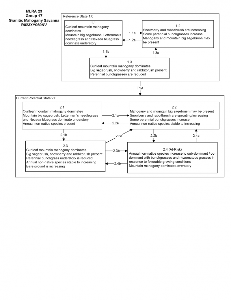
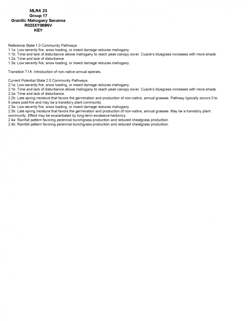
Click on box and path labels to scroll to the respective text.