Provisional. A provisional ecological site description has undergone quality control and quality assurance review. It contains a working state and transition model and enough information to identify the ecological site.
MLRA notes
Major Land Resource Area (MLRA): 024X–Humboldt Basin and Range Area
Major land resource area (MLRA) 24, the Humboldt Area, covers an area of approximately 8,115,200 acres (12,680 sq. mi.). MLRA 24 is found in the Great Basin Section of the Basin and Range Province of the Intermontane Plateaus. Elevations predominantly range from 3,950 to 5,900 feet (1,205 to 1,800 meters). The elevations of some mountain peaks are more than 8,850 feet (2,700 meters).
A series of widely spaced north-south trending mountain ranges are separated by broad valleys filled with alluvium washed in from adjacent mountain ranges. Most valleys are drained by tributaries to the Humboldt River. Playas, however, occur in lower elevation valleys with closed drainage systems. Isolated ranges are dissected, uplifted fault-block mountains.
Geology is comprised of Mesozoic and Paleozoic volcanic rock and marine and continental sediments. Young andesite and basalt flows (6 to 17 million years old) are at the margins of the mountains.
Dominant soil orders include Aridisols, Entisols, Inceptisols and Mollisols. Soils of the area are generally characterized by a mesic soil temperature regime, an aridic soil moisture regime and mixed geology. They are generally well drained, loamy and very deep.
75 percent of MLRA 24 is federally owned. The remainder is primarily used for farming, ranching and mining. Irrigated land comprises 3 percent of the area; most of the irrigation water is from surface water sources, such as the Humboldt River and Rye Patch Reservoir.
Annual precipitation typically ranges from 6 to 12 inches (15 to 30 cm) for most of the area. In the mountains however the precipitation may be up to 40 inches (101 cm). Most of the annual precipitation is from snow in the winter. In the spring and fall, rainfall occurs as high- intensity, convective thunderstorms.
Nevada is on the eastern, lee side of the Sierra Nevada Range; a massive mountain barrier that markedly influences the climate of the State. The prevailing winds are from the west. The warm moist air from the Pacific Ocean ascends the western slopes of the Sierra Range, the air cools, condenses and the moisture falls as precipitation. As the air descends the eastern slope, it is warmed by compression, and very little precipitation occurs. The effects of this mountain barrier are felt not only in the west but throughout the State. The result is the lowlands of Nevada are largely desert or steppes.
Ecological site concept
The central concept for Dunes 6 to 10 ecological site is on thick sand sheets on middle and lower piedmont slopes, and sand sheets. Soils associated with this site are very deep, somewhat excessively drained and formed in eolian and lacustrine sands derived from mixed rocks, with influence from volcanic ash. Soils are characterized by an ochric epipedon, minimal soil development, and coarse textured throughout the profile, the soils have a low to very low available water capacity (AWC) and are somewhat excessively drained.
Important abiotic factors include Basin big sagebrush (ARTR4) and Indian ricegrass (ACHY).
Soils are very deep, well drained and formed in a thin layer of loess and alluvium. The plant community is characterized by the mixing of shadscale (ATCO), and black greasewood (SAVE4).
Soils are characterized by a very low infiltration, an ochric epipedon and moderate to very strong alkalinity. The plant community is characterized by the mixing of shadscale (ATCO) and black greasewood (SAVE4) and approximate canopy cover is less than 15 percent.
Soils have a thick layer of overblown or alluvial sand. These soils have rapid infiltration and percolation rates, very low available water capacity and are somewhat excessively drained with very low runoff. Spiny hopsage (GRSP) and Indian ricegrass (ACHY)
Soils are very deep, well drained and formed in a thin layer of loess and alluvium. Soils are characterized by a very low infiltration. Dominant plants are shadscale (ATCO) and black greasewood (SAVE4)
This site is found on partially stabilized sand dunes that typically occurs adjacent to and on the leeward side of large playas. Black greasewood (SAVE4) dominant shrub; Big sagebrush (ARTR2) rare, if present.
Dunes 6 to 10 is on thick sand sheets on middle and lower piedmont slopes and sand dunes covering pluvial beach terraces. The dunes may be undulating to rolling and partially stabilized. Slopes range from 0 to 30 percent, with some micro-slopes to 60 percent. Elevations are 3,600 to 5,700 feet (1,097 to 1,737 meters).
Table 2. Representative physiographic features
Landforms
(1) Sand sheet (2) Dune
Runoff class
Negligible to very low
Flooding frequency
None
Elevation
1,097–1,737 m
Slope
0–30%
Water table depth
183 cm
Aspect
Aspect is not a significant factor
Climatic features
The climate associated with Dunes 6 to 10 ecological site is considered semiarid. The climate is characterized by cool, moist winters and hot, dry summers. Precipitation occurs from November through May, 70 percent of the time, typically. Average annual precipitation ranges from 6 to 10 inches (15 to 25 cm).
Mean annual air temperature is 45 to 50 degrees F. The average growing season is about 100 to 120 days.
Mean precipitation by month (in inches):
Jan 1.01 (2.57 cm); Feb 0.89 (2.26 cm); Mar 0.92 (2.34 cm);
Apr 1.04 (2.64 cm); May 1.09 (2.77 cm); Jun 0.86 (2.2 cm);
Jul 0.25 (.64 cm); Aug 0.27 (.69 cm); Sept 0.43 (1.09 cm);
Oct 0.78 (1.98 cm); Nov 0.88 (2.24 cm); Dec 0.97 (2.46 cm).
The above data is averaged from Winnemucca Airport and the Orovada WRCC.
Table 3. Representative climatic features
Frost-free period (characteristic range)
75-77 days
Freeze-free period (characteristic range)
103-107 days
Precipitation total (characteristic range)
229-254 mm
Frost-free period (actual range)
75-77 days
Freeze-free period (actual range)
102-108 days
Precipitation total (actual range)
203-254 mm
Frost-free period (average)
76 days
Freeze-free period (average)
105 days
Precipitation total (average)
229 mm
Characteristic range
Actual range
Bar
Line
Figure 1. Monthly precipitation range
Characteristic range
Actual range
Bar
Line
Figure 2. Monthly minimum temperature range
Characteristic range
Actual range
Bar
Line
Figure 3. Monthly maximum temperature range
Bar
Line
Figure 4. Monthly average minimum and maximum temperature
Figure 5. Annual precipitation pattern
Figure 6. Annual average temperature pattern
Climate stations used
(1) WINNEMUCCA MUNI AP [USW00024128], Winnemucca, NV
(2) OROVADA 3 W [USC00265818], Orovada, NV
Influencing water features
Influencing water features are not associated with this site.
Soil features
Soils associated with this site are very deep, and exhibit minimal characteristics associated with soil development. Soils are formed in eolian and lacustrine sands derived from mixed rocks with some influence from volcanic ash. Coarse textured throughout the profile, the soils have a low to very low available water capacity, and are somewhat excessively drained. Soils are very porous and generally not affected by excess salts or sodium except at lower depths in the C horizon in some profiles. Some areas have a water table within the rooting zone of black greasewood. Almost all the precipitation that falls upon this site is available for plant use. Deep-rooted plants are particularly suited to this site as they can take advantage of rapid infiltration and deep percolation of water through the sandy soils. Runoff is negligible to very low. The potential for wind erosion is high. The soils have an ochric epipedon. The soil moisture regime is mesic and the soil temperature regime is aridic bordering on xeric. Soils associated with this site include Goldrun, a mixed, mesic, Xeric Torripsamment.
Subsurface fragment volume <=3" (Depth not specified)
0%
Subsurface fragment volume >3" (Depth not specified)
0%
Ecological dynamics
The plant communities of this site are dynamic in response to changing weather patterns and disturbance regimes. The reference plant community is dominated by Indian ricegrass and basin big sagebrush. Spiny hopsage, winterfat, fourwing saltbush and ephedra are associated shrub species. Needle-and-thread, thickspike wheatgrass, and basin wildrye are other common species.
This ecological site is characterized by coarse textured soils formed from eolian deposits. Soils associated with this ecological site are very deep and exhibit minimal characteristics associated with soil development. In arid and semi-arid systems, coarse-textured soils lose less moisture to evaporation than fine-textured soils and thus have higher water availability (Lane et al 1998). This principle, known as the inverse-texture hypothesis, predicts that plant communities on coarse-textured soils should have higher above-ground net primary productivity than communities on fine-textured soils.
Sand dunes form a unique system that can be mobile or fixed by vegetation. Over the course of geologic time, mobility of sand dunes is related to increasing aridity, and vegetation stabilizes during wet phases (Tsoar 2005). Sandy soils are highly susceptible to wind erosion. Management of the plant community should ensure sufficient plant cover to protect site from soil surface movement. Infiltration is rapid on coarse-textured soil reducing the potential for sheet and rill erosion during typical precipitation events.
Deep-rooted plants are well suited to this site because deep roots can take advantage of rapid infiltration and deep percolation of water. Big sagebrush root systems are well developed, with both lateral roots and tap roots. Tap roots penetrate as deep as six feet (1.8 Meters) (Howard 1999). Research suggests that the taproots of sagebrush plants absorb moisture from the deeper soil horizons and transport it to the lateral roots in the drier upper soil horizons (Richards and Caldwell 1987). Hydraulic lift by deep-rooted species can result in greater competitive ability for limited resources than root distribution would suggest.
Big sagebrush species regenerates solely from seed and do not sprout or layer. Big sagebrush generally flowers and sets seed in late summer and fall. Most seed shatters within a week of maturation and travels less than 100 feet (30.5 meters) from the parent plant. Germination occurs the following spring, cold stratification and light improves germination (Howard 1999). Sagebrush seedlings require sufficient soil moisture to germinate and survive. Mature shrubs, perennial bunchgrasses and litter can create microhabitats with very good germination conditions.
As ecological conditions decline and where management results in abusive grazing by livestock or feral horses, needle and thread and Indian ricegrass decrease. Sandberg's bluegrass and bottlebrush squirreltail increase and become the dominant understory vegetation. Further site deterioration, cheatgrass and annual mustards replace perennial grasses and dominate the understory. The dominant overstory vegetation becomes big sagebrush, rabbitbrush, and horsebrush. Cheatgrass, halogeton, annual mustards, and Russian thistle are species likely to invade this site. Reduction in plant cover or changes in plant community composition and structure increases the risk of active soil movement and dune creation or flattening.
Fire Ecology:
Sagebrush steppe communities have historically been subject to fires at varying intervals (25 to 70+ years). Fire severity in big sagebrush communities is described as variable depending on weather, fuels, and topography. Fire is the principal means of renewal for decadent stands of big sagebrush. Basin big sagebrush and Wyoming big sagebrush are readily killed when aboveground plant parts are charred by fire. Prolific seed production from nearby unburned plants coupled with high germination and survival rates is required to ensure establishment following fire.
In many big sagebrush communities, fire frequency, intensity and fire suppression have changed. Livestock grazing, and off-road vehicle use have also changed. Invasion of cheatgrass, mustards, and other annual non-natives decreases site resilience, increases the risk of stand-replacing fires, and decreases the potential for sagebrush and perennial grass establishment. Continual sand movement and subsequent burying of seed may prohibit seedling establishment.
Spiny hopsage is somewhat fire tolerant and commonly survives fires that kill sagebrush. Mature spiny hopsage generally sprout after being burned. Spiny hopsage is reported to be least susceptible to fire during summer dormancy. Indian ricegrass can be killed by fire, depending on severity and season of burn. Indian ricegrass reestablishes on burned sites through seed dispersed from adjacent unburned areas.
Needle-and-thread grass is top-killed by fire. It may be killed if the aboveground stems are completely consumed. Needle-and-thread grass is classified as slightly to severely damaged by fire. Needle-and-thread grass sprouts from the caudex following fire, if heat has not been sufficient to kill underground parts. Recovery typically takes 2 to 10 years.
Thickspike wheatgrass is quite tolerant of fire. Subsurface growing points and primarily rhizomatous reproduction may explain its ability to increase rapidly (within 2-5 years) following burning.
Basin wildrye is top-killed by fire. Older basin wildrye plants with large proportions of dead material within the perennial crown can be expected to show higher mortality due to fire than younger plants having little debris. Basin wildrye is generally tolerant of fire but may be damaged by early season fire combined with dry soil conditions.
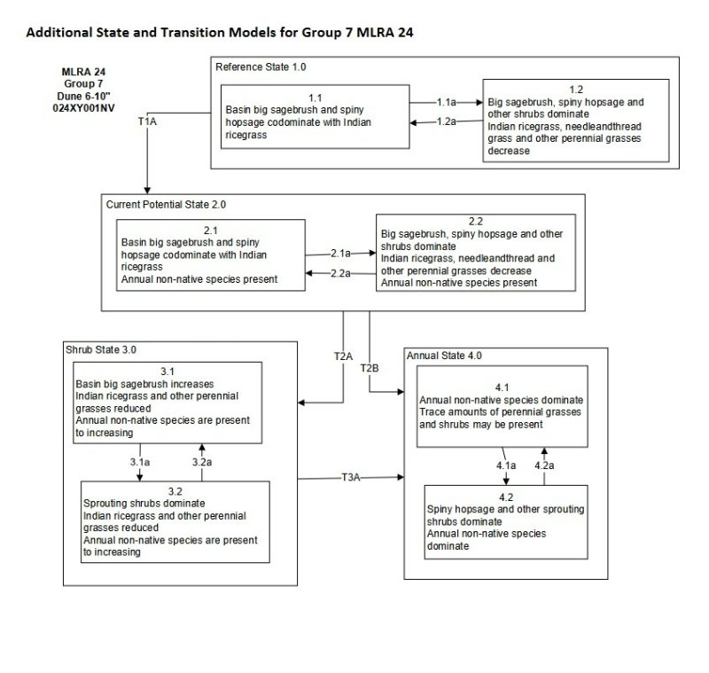
Trigger: Introduction of non-native annual species.
Slow variables: Changes in the kinds of animals and their grazing patterns, drought and/or changes in fire history that altered recruitment rates of native species.
Threshold: Reduction in deep-rooted herbaceous understory reduces productivity, changes nutrient cycling and soil stability. Annual non-native species cannot be easily removed from the system and have the potential to significantly alter disturbance regimes from their historic range of variation.
T2A
-
Trigger: Inadequate rest and recovery from growing season defoliation and/or prolonged drought.
Slow variables: Long term decrease in grass density and reduced native species (shrub and grass) recruitment rates. Increased reproduction of non-native species.
Threshold: Loss of deep-rooted perennial bunchgrasses changes nutrient cycling, nutrient redistribution, and reduces soil organic matter.
T2B
-
Trigger: Multiple stand replacing fires eliminate sagebrush and severely damage spiny hopsage. Typically occurs in the hot season.
Slow variables: Increased reproduction and cover of non-native invasive annuals.
Threshold: Loss of deep-rooted perennial bunchgrasses reduces infiltration and increases runoff; this leads to reduced soil organic matter and soil moisture. Modified fire regime (changes in intensity, size and spatial variability of fires).
T3A
-
Trigger: Multiple fires within a 10 to 20 year timeframe
Slow Variables: Increased reproduction, cover and density of non-native annuals
Threshold: Modified fire regime (changes in frequency, intensity, size and spatial variability of fire). Changes in plant community composition and spatial variability of vegetation (loss of perennial bunchgrasses and sagebrush).
This community pathway is a result of fire, insect or disease attack.
1.1B
-
This community pathway is a result of prolonged drought, inadequate rest and recovery from defoliation and the absence or fire or other natural disturbances.
1.2A
-
This community pathway is a result of absence of disturbance and natural regeneration over time. Ten years or greater is required for big sagebrush to reach pre-fire conditions (Tirmenstein 1999).
1.3A
-
This pathway is a result of fast moving, low intensity fire, Aroga moth infestation of big sagebrush, adequate rest and recovery from defoliation or a release from drought which removes shrub overstory and releases bunchgrass understory.
1.3B
-
This community phase pathway is a result of stand replacing fire or other natural disturbance that reduce shrub cover and invigorates the perennial bunchgrass community.
This community phase pathway is a result of fire, insect or disease attack.
2.1B
-
This community pathway is a result of prolonged drought, inadequate rest and recovery from defoliation and absence of fire or other natural disturbance.
2.2A
-
The community pathway is a result of absence of disturbance and natural regeneration over time. Ten years or greater is required for big sagebrush to reach pre-fire conditions (Tirmenstein 1999).
2.3A
-
This community pathway is a result of fast moving, low intensity fire, Aroga moth infestation, adequate rest and recovery from defoliation or release from drought which removes shrub overstory and releases bunchgrass understory.
2.3B
-
This community phase pathway is a result of stand replacing fire (most likely during the dormant season) insect or disease attack. Non-native annuals may increase.
This community phase pathway is a result of fire, insect or disease attack.
3.2A
-
This community phase pathway is a result of absence of disturbance (fire return interval >20 years) and natural regeneration over time (if a seed source is present for sagebrush).
This pathway is a result of time without disturbance to facilitate sprouting of shrubs.
4.2a
-
This community phase pathway is a result of fire.
State 1 Reference State
The reference state is representative of the natural range of variability under pristine conditions. The reference state has three general community phases; a perennial grass dominant phase, a shrub-grass dominant phase and a shrub dominant phase. State dynamics are maintained by interactions between climatic patterns and disturbance regimes. Negative feedbacks enhance ecosystem resilience and contribute to the stability of the state. These include the presence of all structural and functional groups, low fine fuel loads, and retention of organic matter and nutrients. Plant community phase changes are primarily driven by fire, periodic drought and/or insect or disease attack.
Community 1.1 Reference Plant Community 1.1
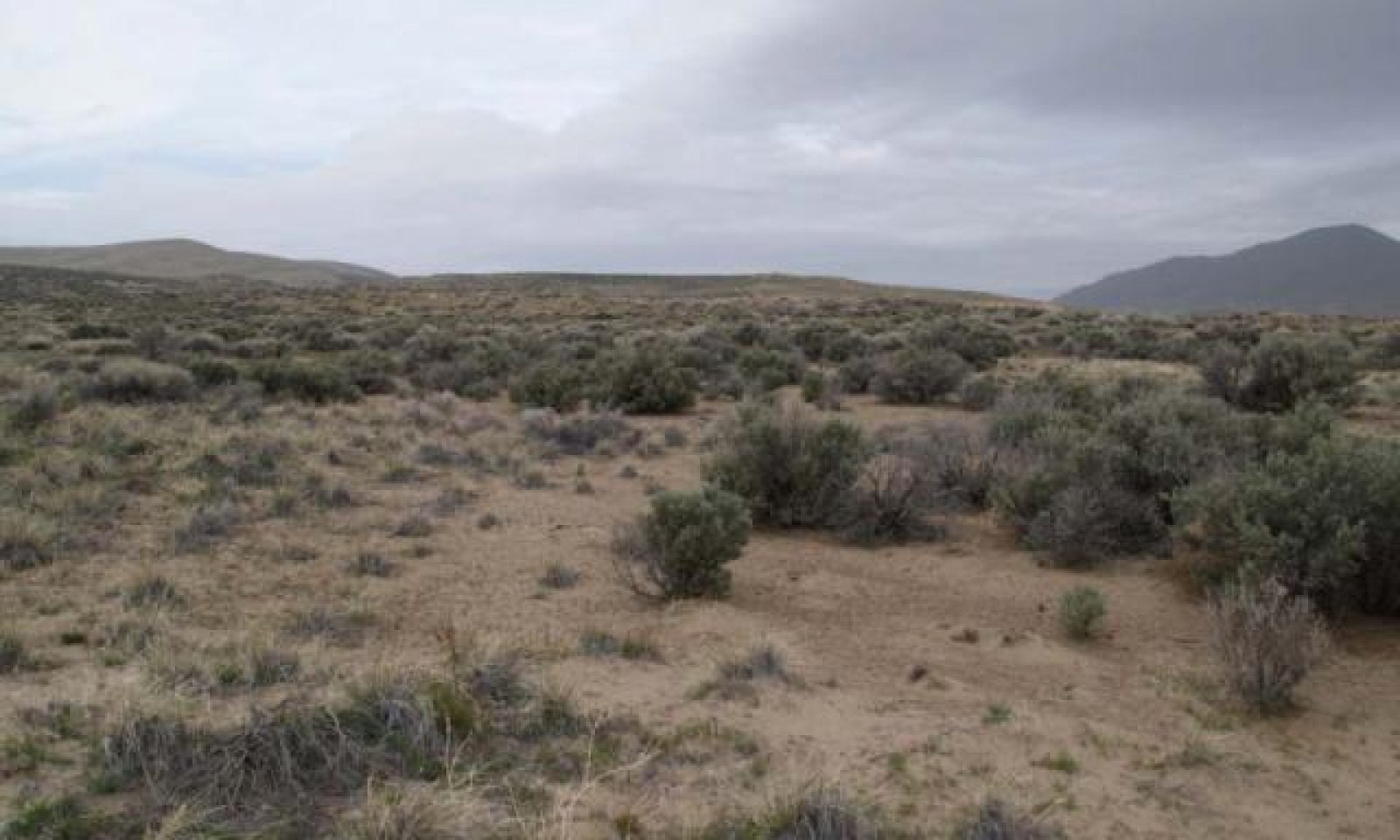
The visual aspect of the plant community is open canopy of perennial bunchgrasses and soft-woody shrubs. Dominant species include basin big sagebrush, Indian ricegrass and needleandthread. Spiny hopsage, thickspike wheatgrass and basin wildrye are important associated species. Potential vegetative composition is about 55 percent grasses, 10 percent forbs and 35 percent shrubs. Approximate ground cover (basal and crown) is 15 to 25 percent.
Figure 9. Annual production by plant type (representative values) or group (midpoint values)
Table 5. Annual production by plant type
Plant type
Low (kg/hectare)
Representative value (kg/hectare)
High (kg/hectare)
Grass/Grasslike
185
308
493
Shrub/Vine
118
196
314
Forb
34
56
90
Total
337
560
897
Community 1.2 Plant community 1.2
This plant community phase is characteristic of a post-disturbance, early seral community phase. This community is dominated by Indian ricegrass, needleandthread, and basin wildrye; big sagebrush decreases after fire and perennial bunchgrasses initially increase. Spiny hopsage and ephedra sprout from the root crown following fire and may increase. Scurfpea and rabbitbrush are common. Sagebrush may be present in trace amounts or in unburned islands. Fast moving, low intensity wildfire results in the incomplete removal of sagebrush allowing for direct reestablishment and a faster recovery. This plant community phase is at risk of invasion by non-native species. Non-natives are able to take advantage of increased availability of critical resources following disturbance.
Community 1.3 Plant Community 1.3
This plant community phase is characterized by a decadent overstory of basin big sagebrush, along with spiny hopsage and other shrubs. Perennial grasses are declining from drought, competition from over-mature shrub overstory, and inadequate rest and recovery from defoliation. In the absence of disturbance, sagebrush communities become monotypic stands of late successional plants. This results in reduced quantity and diversity of plant species, reduced sagebrush vigor and seed production. Over-mature sagebrush plants are very competitive for water, light and nutrients, preventing recruitment and establishment of other vegetation and increasing the amount of bare ground. This plant community is at risk of invasion by non-native species. Non-natives can easily invade plant communities where structural and functional groups are reduced. Increased bare ground is an indicator of site susceptibility to accelerated wind erosion.
Pathway 1.1A Community 1.1 to 1.2
This community pathway is a result of fire, insect or disease attack.
Pathway 1.1B Community 1.1 to 1.3
This community pathway is a result of prolonged drought, inadequate rest and recovery from defoliation and the absence or fire or other natural disturbances.
Pathway 1.2A Community 1.2 to 1.1
This community pathway is a result of absence of disturbance and natural regeneration over time. Ten years or greater is required for big sagebrush to reach pre-fire conditions (Tirmenstein 1999).
Pathway 1.3A Community 1.3 to 1.1
This pathway is a result of fast moving, low intensity fire, Aroga moth infestation of big sagebrush, adequate rest and recovery from defoliation or a release from drought which removes shrub overstory and releases bunchgrass understory.
Pathway 1.3B Community 1.3 to 1.2
This community phase pathway is a result of stand replacing fire or other natural disturbance that reduce shrub cover and invigorates the perennial bunchgrass community.
State 2 State 2
This state is characterized by the presence of non-native invasive species in the understory. This state is similar to the Reference State (1) and has the same three general community phases. Ecological function has not changed, however, the resiliency of the state has been reduced by the presence of invasive weeds. Prescribed grazing and infrequent fire maintains state dynamics. These non-natives are highly flammable and can promote wildfire where fires historically have been infrequent. Negative feedbacks enhance ecosystem resilience and contribute to the stability of the state. These include the presence of all structural and functional groups, low fine fuel loads and retention of organic matter and nutrients. Positive feedbacks decrease ecosystem resilience and stability of the state. These include the non-natives high seed output, persistent seed bank, rapid growth rate, ability to cross pollinate and adaptations for seed dispersal.
Community 2.1 Plant community 2.1
Figure 10. Plant community 2.1
This plant community phase is compositionally similar to 1.1 Plant Community with a trace of non-native annuals (cheatgrass and mustard). Ecological processes (soil hydrology properties, nutrient cycling and productivity) are also similar to 1.1 plant community. Ecological resilience has been reduced by the presence of non-native annual species and this community may respond differently following a disturbance, when compared to non-invaded plant communities.
Community 2.2 Plant community 2.2
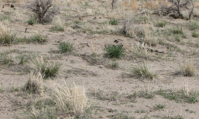
Figure 11. after wildfire
This plant community is characteristic of a post-disturbance, early seral community phase. The visual aspect of the plant community is dominated by Indian ricegrass, needleandthread, and basin wildrye; big sagebrush decreases after fire and perennial bunchgrasses initially increase. Spiny hopsage and ephedra sprout from the root crown following fire and may increase in cover. Sagebrush may be present in trace amounts or in unburned islands. Fast moving, low intensity wildfire results in the incomplete removal of sagebrush allowing for direct reestablishment and a faster recovery. Annual non-native species are present in the understory and maybe stable to increasing, depending on weather patterns and management decisions. In above-normal precipitation years, production may range from 900 to 1200 lbs/ac.
Community 2.3 Plant Community 2.3 (at-risk)
The at-risk plant community of state 2 is characterized by the over-dominance of sagebrush and other shrubs. In response to inadequate rest and recovery from defoliation, perennial grasses decline and the shrub overstory becomes dominant. Annual non-native species are stable or increasing within the understory. Bare ground is increasing. Resistance of the plant community to wind erosion and further weed invasion is reduced. Further disturbance, such as frequent fire and inadequate rest and recovery from defoliation this plant community will likely cross a threshold to State 3 or 4.
Pathway 2.1A Community 2.1 to 2.2
Plant community 2.1
Plant community 2.2
This community phase pathway is a result of fire, insect or disease attack.
Pathway 2.1B Community 2.1 to 2.3
This community pathway is a result of prolonged drought, inadequate rest and recovery from defoliation and absence of fire or other natural disturbance.
Pathway 2.2A Community 2.2 to 2.1
Plant community 2.2
Plant community 2.1
The community pathway is a result of absence of disturbance and natural regeneration over time. Ten years or greater is required for big sagebrush to reach pre-fire conditions (Tirmenstein 1999).
Pathway 2.3A Community 2.3 to 2.1
This community pathway is a result of fast moving, low intensity fire, Aroga moth infestation, adequate rest and recovery from defoliation or release from drought which removes shrub overstory and releases bunchgrass understory.
Pathway 2.3B Community 2.3 to 2.2
This community phase pathway is a result of stand replacing fire (most likely during the dormant season) insect or disease attack. Non-native annuals may increase.
State 3 State 3
This state has crossed a biotic threshold and site processes (soil hydrology, nutrient cycling, and energy capture) are being controlled by the shrub component of the plant community. Perennial bunchgrass may or may not be present in trace amounts. The herbaceous understory is dominated by annual non-native species such as cheatgrass and mustards. Resiliency has declined and further degradation from fire facilitates a cheatgrass and sprouting shrub plant community. Fire return interval has shortened due to the dominance of cheatgrass in the understory and is a driver in site dynamics. Sagebrush may be eliminated by continued fire. Spiny hopsage and ephedra may resprout if grazing is controlled and drought does not occur following fire. Negative feedbacks enhance ecosystem resilience and contribute to stability of this state. These include the persistent seedbank and competitive ability of cheatgrass.
Community 3.1 Plant community 3.1
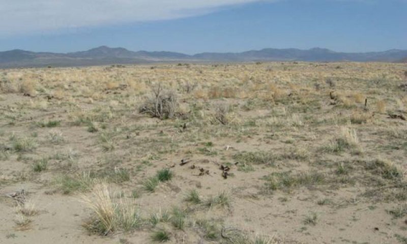
Figure 12. Dunes 6-10 Community Phase 3.1 NV769 MU270 Goldrun Soil T. Stringham
Sagebrush and various native shrubs associated with this site dominate the overstory. Cheatgrass, mustards and other annual weeds dominate the understory. Native perennial grass component is significantly reduced. Native species exhibit reduced vigor and reproductive capacity due to competition from non-native species and shrub overstory. Prolonged drought may result in overall reduction of the plant community. This plant community is at risk of increased fire, due to fuel provided by non-natives.
Community 3.2 Plant community 3.2 (at risk)
This plant community phase is dominated by non-native annuals. After fire, spiny hopsage, ephedra and rabbitbrush may sprout from the root crown. Sagebrush is present in trace amounts, if at all. Annual species dominate the understory and control ecological processes (soil hydrology, nutrient cycling, energy capture). This plant community is at risk of reoccurring fire, due to the continuous fuel bed provided by non-native annuals.
Reduced native perennials and increasing bare ground reduces ecological resistance and this plant community is at risk of crossing an irreversible threshold into State 4.
Pathway 3.1A Community 3.1 to 3.2
This community phase pathway is a result of fire, insect or disease attack.
Pathway 3.2A Community 3.2 to 3.1
This community phase pathway is a result of absence of disturbance (fire return interval >20 years) and natural regeneration over time (if a seed source is present for sagebrush).
State 4 State 4
This state has two community phases, with the primary phase (4.1) dominated by non-native annuals characterized by frequent fire. This state has crossed both a biotic and abiotic threshold. Annual non-native species, including cheatgrass, mustards and Russian thistle, dominate the plant community. Sprouting shrubs may be present in trace amounts; sagebrush is missing. Ecological processes are controlled by the non-native annual community during the spring growing season and by the physical process of wind movement of soil after the annual plant cover has senesced. In extremely degraded sites, wind erosion of soil may progress to dune formation or flattening (depending on landscape position) and near elimination of the annual plant community. Negative feedbacks contributing to the stability of this state include the persistence of non-natives and competition from non-natives for soil moisture and nutrients prevent recruitment of native species. Fine fuels provided by non-native annuals support a fire regime that is often too frequent for the successful establishment of sagebrush and favor an increase in non-native invasive annuals, however if time between fires is long enough sagebrush can return although this is a rare occurrence it is possible.
Community 4.1 Plant community 4.1
Annual species, primarily mustards and cheatgrass, dominate this community phase. Canopy cover and litter cover, during average and above-average precipitation years, is typically greater than 50 percent. Litter cover provides safe sites for the germination of cheatgass. Average soil stability values range from 1 to 3, which indicates low resistance to erosion. Trace amounts of perennial grasses or sprouting shrubs may be present. Annual production, dominated by cheatgrass and mustard, ranges from 1000-1300 pounds per acre in an average precipitation year.
Fire occurs frequent enough in this state to eliminate the reestablishment of sagebrush or dominance of sprouting shrubs. Extensive soil movement also precludes the natural reestablishment of shrub and herbaceous species. Restoration practices include stabilization of soil, control of non-natives, and seeding of native species during a high-rainfall period.
Community 4.2 Plant community 4.2
Sagebrush and/or sprouting shrubs dominate the overstory. Cheatgrass, annual mustards and other non-native annual species dominate the understory. This phase is very at risk of fire and conversion to an annual dominated site.
Pathway 4.1a Community 4.1 to 4.2
This pathway is a result of time without disturbance to facilitate sprouting of shrubs.
Pathway 4.2a Community 4.2 to 4.1
This community phase pathway is a result of fire.
Transition T1A State 1 to 2
Trigger: Introduction of non-native annual species.
Slow variables: Changes in the kinds of animals and their grazing patterns, drought and/or changes in fire history that altered recruitment rates of native species.
Threshold: Reduction in deep-rooted herbaceous understory reduces productivity, changes nutrient cycling and soil stability. Annual non-native species cannot be easily removed from the system and have the potential to significantly alter disturbance regimes from their historic range of variation.
Transition T2A State 2 to 3
Trigger: Inadequate rest and recovery from growing season defoliation and/or prolonged drought.
Slow variables: Long term decrease in grass density and reduced native species (shrub and grass) recruitment rates. Increased reproduction of non-native species.
Threshold: Loss of deep-rooted perennial bunchgrasses changes nutrient cycling, nutrient redistribution, and reduces soil organic matter.
Transition T2B State 2 to 4
Trigger: Multiple stand replacing fires eliminate sagebrush and severely damage spiny hopsage. Typically occurs in the hot season.
Slow variables: Increased reproduction and cover of non-native invasive annuals.
Threshold: Loss of deep-rooted perennial bunchgrasses reduces infiltration and increases runoff; this leads to reduced soil organic matter and soil moisture. Modified fire regime (changes in intensity, size and spatial variability of fires).
Transition T3A State 3 to 4
Trigger: Multiple fires within a 10 to 20 year timeframe
Slow Variables: Increased reproduction, cover and density of non-native annuals
Threshold: Modified fire regime (changes in frequency, intensity, size and spatial variability of fire). Changes in plant community composition and spatial variability of vegetation (loss of perennial bunchgrasses and sagebrush).
Additional community tables
Table 6. Community 1.1 plant community composition
Livestock Interpretations:
This site has value for livestock grazing. Grazing management should be keyed to dominant grasses and palatable shrub production. Basin big sagebrush may serve as emergency food during severe winter weather, but it is not typically sought out by livestock. Spiny hopsage provides a palatable and nutritious food source for livestock, particularly during late winter through spring. Domestic sheep browse the succulent new growth of spiny hopsage in late winter and early spring.
Indian ricegrass is highly palatable to all classes of livestock in both green and cured condition. It supplies a source of green feed before most
other native grasses have produced much new growth. Heavy spring grazing sharply reduces the vigor of Indian ricegrass and decrease the stand (Cook and Child 1971). In eastern Idaho, productivity of Indian ricegrass was at least 10 times greater in undisturbed
plots than in heavily grazed ones (Pearson 1976). Cook and Child (1971) describe significant reduction in plant cover after 7 years of rest from heavy (90 percent) and moderate (60 percent) spring use. The seed crop may be reduced where grazing is heavy (Bich et al. 1995). Tolerance to grazing increases after May thus spring deferment may be necessary for stand enhancement (Pearson 1964; Cook and Child 1971), however utilization of less than 60 percent is recommended.
Needle-and-thread provides highly palatable forage, especially in the spring before fruits have developed. Needlegrasses are grazed in the fall only if the fruits are softened by rain. Thickspike wheatgrass is palatable to all classes of livestock and wildlife. It is a preferred feed for cattle, sheep, horses, and elk in spring and is considered a desirable feed for deer and antelope in spring. It is considered a desirable feed for cattle, sheep, and horses in summer, fall, and winter. Thickspike wheatgrass's extensive rhizome system allows established stands to withstand heavy grazing and trampling. The early growth and abundant production of basin wildrye make it a valuable source of forage for livestock. It is important forage for cattle and is readily grazed by cattle and horses in early spring and fall. Though coarse textured during the winter, basin wildrye may be utilized more commonly by livestock and wildlife when snow has covered low shrubs and other grasses.
Stocking rates vary over time depending upon season of use, climate variations, site, and previous and current management goals. A safe starting stocking rate is an estimated stocking rate that is fine-tuned by the client by adaptive management through the year and from year to year.
Wildlife Interpretations:
Basin big sagebrush is the least palatable of all the subspecies of big sagebrush. Basin big sagebrush is browsed by mule deer from fall to early spring but is not preferred. Spiny hopsage provides a palatable and nutritious food source for big game animals. Spiny hopsage is used as forage to at least some extent by domestic goats, deer, pronghorn, and rabbits. Indian ricegrass is eaten by pronghorn in moderate amounts whenever available. Several heteromyid rodents inhabiting desert rangelands show preference for seed of Indian ricegrass. Indian ricegrass is an important component of jackrabbit diets in spring and summer. In Nevada, Indian ricegrass may even dominate jackrabbit diets during the spring through early summer months. Indian ricegrass seed provides food for many species of birds. Doves, for example, eat large amounts of shattered Indian ricegrass seed lying on the ground. Needle-and-thread is moderately important spring forage for mule deer but use declines considerably as more preferred forages become available. In the spring, it is a preferred feed for elk and is considered desirable feed for deer and antelope. It is desirable feed for elk during summer, fall, and winter. Thickspike wheatgrass is also a component of black-tailed jackrabbit diets. Thickspike wheatgrass provides some cover for small mammals and birds. Basin wildrye provides winter forage for mule deer, though use is commonly low compared to other native grasses. Basin wildrye provides summer forage for black-tailed jackrabbits. Because basin wildrye remains green throughout early summer, it remains available for small mammal forage for longer time than other grasses.
Sagebrush-grassland communities provide critical sage-grouse breeding and nesting habitats. Sagebrush is a crucial component of their diet year-round, and sage-grouse select sagebrush almost exclusively for cover. Sage-grouse prefer mountain big sagebrush and Wyoming big sagebrush communities to basin big sagebrush communities.
Hydrological functions
Runoff is very low to low. Permeability is rapid. Hydrologic soil groups are A. Rills are none. Water flow patterns none. Pedestals are common due to wind scouring. Gullies are none. Perennial herbaceous plants (especially deep-rooted bunchgrasses [i.e., Indian ricegrass]) slow runoff and increase infiltration. Shrub canopy and associated litter break raindrop impact.
Recreational uses
Aesthetic value is derived from the diverse floral and faunal composition and the colorful flowering of wild flowers and shrubs during the spring and early summer. This site offers rewarding opportunities to photographers and for nature study. This site has potential for upland bird and big game hunting.
Other products
Native Americans use the bark of big sagebrush to make rope and baskets. Native Americans traditionally grind parched seeds of spiny hopsage to make pinole flour. Indian ricegrass is traditionally eaten by Native Americans. The Paiutes use seed as a reserve food source. Basin wildrye is used as bedding for various Native American ceremonies, providing a cool place for dancers to stand.
Other information
Basin big sagebrush has high potential for range restoration and soil stabilization. Basin big sagebrush grows rapidly and spreads readily from seed. Spiny hopsage has moderate potential for erosion control and low to high potential for long-term revegetation projects. Spiny hopsage can improve forage, control wind erosion, and increase soil stability on gentle to moderate slopes. Needle-and-thread grass is useful for stabilizing
eroded or degraded sites. Thickspike is a good revegetation species because it forms tight sod under dry rangeland conditions, has good seedling strength, and performs well in low fertility or eroded sites. It does not compete well with aggressive introduced grasses during the establishment period, but are very compatible with slower developing natives, bluebunch wheatgrass (Pseudoroegneria spicata), western wheatgrass (Pascopyrum smithii), and needlegrass (Achnatherum spp.) species. Thickspike's drought tolerance combined with rhizomes, fibrous root systems, and good seedling vigor make these species ideal for reclamation in areas receiving 8 to 20 inches (20 to 51 cm) annual precipitation. Thickspike wheatgrass can be used for hay production and will make nutritious feed, but is more suited to pasture use. Basin wildrye is useful in mine reclamation, fire rehabilitation and stabilizing disturbed areas. Its usefulness in range seeding, however, may be limited by initially weak stand establishment.
Supporting information
Inventory data references
NASIS soil mapunit data correlated to ecological site.
Type locality
Location 1: Humboldt County, NV
Township/Range/Section
T35N R37E S17
UTM zone
N
UTM northing
429126
UTM easting
4528994
Latitude
40° 54′ 32″
Longitude
117° 50′ 29″
General legal description
NW¼ NW¼ About 6 miles west of Winnemuca, at I80 mile marker 171 (eastbound right-of-way) Humboldt County, Nevada. This site also occurs in Elko, Eureka, Lander, Pershing, and Washoe Counties, Nevada.
Other references
Bich, B.S., J.L. Butler, and C.A. Schmidt. 1995. Effects of differential livestock use of key plant species and rodent populations within selected Oryzopsis hymenoides/Hilaria jamesii communities in Glen Canyon National Recreation Area. The Southwestern Naturalist 40(3):281-287.
Blauer, A.C., A.P. Plummer, E.D. McArthur, R. Stevens, and B.C. Giunta. 1976. Characteristics and hybridization of important Intermountain shrubs. II. Chenopod family. Res. Pap. INT-177. Ogden, UT. U.S. Department of Agriculture, Forest Service, Intermountain Forest and Range Experiment Station. 42 p.
Bunting, S.C., B.M. Kilgore, and C.L. Bushey. 1987. Guidelines for prescribed burning sagebrush-grass rangelands in the northern Great Basin. Gen. Tech. Rep. INT-231. Ogden, UT. U.S. Department of Agriculture, Forest Service, Intermountain Research Station. 33 p.
Cook, C.W. and R.D. Child. 1971. Recovery of desert plants in various states of vigor. Journal of Range Management 24(5):339-343.
Daubenmire, R. 1970. Steppe vegetation of Washington. Technical Bulletin 62. Pullman, WA: Washington State University, College of Agriculture, Washington Agricultural Experiment Station. 131 p.
Goodrich, S., E.D. McArthur, and A.H. Winward. 1985. A new combination and a new variety in Artemisia tridentata. The Great Basin Naturalist 45(1):99-104.
Humphrey, L.D. 1984. Patterns and mechanisms of plant succession after fire on Artemisia-grass sites in southeastern Idaho. Vegetatio 57:91-101.
Johnson, J.R. and G.F. Payne. 1968. Sagebrush reinvasion as affected by some environmental influences. Journal of Range Management 21:209-213.
Lane, D.R., D.P. Coffin and W.K. Lauenroth. 1998. Effects of soil texture and precipitation on above ground net primary productivity and vegetation structure across the central grassland region of the United States. Journal of Vegetation Science. 9:239-250.
Pearson, L.C. 1964. Effect of harvest date on recovery of range grasses and shrubs. Agronomy Journal 56:80-82.
Pearson, L.C. 1976. Primary production in grazed and ungrazed desert communities of eastern Idaho. Ecology 46(3):278-285.
Richards, J.H. and M.M. Caldwell. 1987. Hydraulic lift: substantial nocturnal water transport between soil layers by Artemisia tridentata roots. Oecologia. 73:486-489.
Rickard, W.H. and M.C. McShane. 1984. Demise of spiny hopsage shrubs following summer wildfire: an authentic record. Northwest Science 58(4):282-285.
Sapsis, D.B. and J.B. Kauffman. 1991. Fuel consumption and fire behavior associated with prescribed fires in sagebrush ecosystems. Northwest Science 65(4):173-179.
Shaw, N.L. 1992. Germination and seedling establishment of spiny hopsage (Grayia spinosa [Hook.] Moq.). Corvallis, OR: Oregon State University. 174 p. Dissertation.
Shumar, M.L. and J.E. Anderson. 1986. Gradient analysis of vegetation dominated by two subspecies of big sagebrush. Journal of Range Management 39(2):156-159.
Tirmenstein, D. 1999. Artemisia tridentata spp. tridentata. In: Fire Effects Information System, [Online]. U.S. Department of Agriculture, Forest Service, Rocky Mountain Research Station, Fire Sciences Laboratory (Producer). Available: http://www.fs.fed.us/database/feis/
Tsoar, H. 2005. Sand dunes mobility and stability in relation to climate. Physica A 357:50-56.
Wasser, C.H. 1982. Ecology and culture of selected species useful in revegetating disturbed lands in the West. FWS/OBS-82/56. Washington, DC: U.S. Department of the Interior, Fish and Wildlife Service. 347 p.
Webb, R.H. and S.S. Stielstra. 1979. Sheep grazing effects on Mojave Desert vegetation and soils. Environmental Management 3(6):517-529.
Young, R.P. 1983. Fire as a vegetation management tool in rangelands of the Intermountain Region. In: Monsen, S.B. and N. Shaw (compilers). Managing Intermountain rangelands--improvement of range and wildlife habitats: Proceedings; 1981 September 15-17; Twin Falls, ID; 1982 June 22-24; Elko, NV. Gen. Tech. Rep. INT-157. Ogden, UT: U.S. Department of Agriculture, Forest Service, Intermountain Forest and Range Experiment Station: 18-31.
Contributors
GKB
Approval
Kendra Moseley, 3/06/2025
Rangeland health reference sheet
Interpreting Indicators of Rangeland Health is a qualitative assessment protocol used to
determine ecosystem condition based on benchmark characteristics described in the Reference Sheet. A suite of 17 (or
more) indicators are typically considered in an assessment. The ecological site(s) representative of an assessment
location must be known prior to applying the protocol and must be verified based on soils and climate. Current plant
community cannot be used to identify the ecological site.
Author(s)/participant(s)
Patti Novak-Echenique
Contact for lead author
State Rangeland Management Specialist
Date
12/02/2009
Approved by
Kendra Moseley
Approval date
Composition (Indicators 10 and 12) based on
Annual Production
Indicators
Number and extent of rills:
None
Presence of water flow patterns:
None
Number and height of erosional pedestals or terracettes:
Pedestals are few with occurrence due to wind scouring. After wildfires, the remaining vegetation may become severely pedestalled
Bare ground from Ecological Site Description or other studies (rock, litter, lichen, moss, plant canopy are
not bare ground):
Bare Ground 50 to 60 percent.
Number of gullies and erosion associated with gullies:
None
Extent of wind scoured, blowouts and/or depositional areas:
Slight to moderate wind scouring. Severe blowouts and flattening of dunes may occur after severe wildfires and the resulting loss of vegetation
Amount of litter movement (describe size and distance expected to travel):
Fine litter (foliage from grasses and annual & perennial forbs) expected to move unsheltered distance during heavy wind. Persistent litter (large woody material) will remain in place except during intense summer convection storms
Soil surface (top few mm) resistance to erosion (stability values are averages - most sites will show a range
of values):
Soil stability values should be 1 to 3 on the sandy soil textures found on this site. (To be field tested.)
Soil surface structure and SOM content (include type of structure and A-horizon color and thickness):
Surface structure is single grained. Soil surface colors are light and soils are typified by an ochric epipedon. Organic matter of the surface 2 to 3 inches is typically 1 to 1.5 percent dropping off quickly below. Organic matter content can be more or less depending on micro-topography
Effect of community phase composition (relative proportion of different functional groups) and spatial
distribution on infiltration and runoff:
Perennial herbaceous plants (especially deep-rooted bunchgrasses [i.e., Indian ricegrass]) slow runoff and increase infiltration. Shrub canopy and associated litter break raindrop impact
Presence and thickness of compaction layer (usually none; describe soil profile features which may be
mistaken for compaction on this site):
Compacted layers are none.
Functional/Structural Groups (list in order of descending dominance by above-ground annual-production or live foliar
cover using symbols: >>, >, = to indicate much greater than, greater than, and equal to):
Amount of plant mortality and decadence (include which functional groups are expected to show mortality or
decadence):
Dead branches within individual shrubs common and standing dead shrub canopy material may be as much as 25 percent of total woody canopy; some of the mature bunchgrasses (less than 25 percent) have dead centers.
Average percent litter cover (%) and depth ( in):
Under shrubs and between plant interspaces (15-20%) and depth (± ¼in.)
Expected annual annual-production (this is TOTAL above-ground annual-production, not just forage annual-production):
For normal or average growing season (February thru May) ± 500 lbs/ac; Spring moisture significantly affects total production.
Potential invasive (including noxious) species (native and non-native). List species which BOTH characterize
degraded states and have the potential to become a dominant or co-dominant species on the ecological site if
their future establishment and growth is not actively controlled by management interventions. Species that become
dominant for only one to several years (e.g., short-term response to drought or wildfire) are not invasive
plants. Note that unlike other indicators, we are describing what is NOT expected in the reference state for the
ecological site:
Potential invaders include cheatgrass, halogeton, Russian thistle, and annual mustards.
Perennial plant reproductive capability:
All functional groups should reproduce in average (or normal) and above average growing season years.
The Ecosystem Dynamics Interpretive Tool is an information system framework developed by the USDA-ARS Jornada Experimental Range, USDA Natural Resources Conservation Service, and New Mexico State University.
Click on box and path labels to scroll to the respective text.
Trigger: Introduction of non-native annual species.
Slow variables: Changes in the kinds of animals and their grazing patterns, drought and/or changes in fire history that altered recruitment rates of native species.
Threshold: Reduction in deep-rooted herbaceous understory reduces productivity, changes nutrient cycling and soil stability. Annual non-native species cannot be easily removed from the system and have the potential to significantly alter disturbance regimes from their historic range of variation.
T2A
-
Trigger: Inadequate rest and recovery from growing season defoliation and/or prolonged drought.
Slow variables: Long term decrease in grass density and reduced native species (shrub and grass) recruitment rates. Increased reproduction of non-native species.
Threshold: Loss of deep-rooted perennial bunchgrasses changes nutrient cycling, nutrient redistribution, and reduces soil organic matter.
T2B
-
Trigger: Multiple stand replacing fires eliminate sagebrush and severely damage spiny hopsage. Typically occurs in the hot season.
Slow variables: Increased reproduction and cover of non-native invasive annuals.
Threshold: Loss of deep-rooted perennial bunchgrasses reduces infiltration and increases runoff; this leads to reduced soil organic matter and soil moisture. Modified fire regime (changes in intensity, size and spatial variability of fires).
T3A
-
Trigger: Multiple fires within a 10 to 20 year timeframe
Slow Variables: Increased reproduction, cover and density of non-native annuals
Threshold: Modified fire regime (changes in frequency, intensity, size and spatial variability of fire). Changes in plant community composition and spatial variability of vegetation (loss of perennial bunchgrasses and sagebrush).
This community pathway is a result of fire, insect or disease attack.
1.1B
-
This community pathway is a result of prolonged drought, inadequate rest and recovery from defoliation and the absence or fire or other natural disturbances.
1.2A
-
This community pathway is a result of absence of disturbance and natural regeneration over time. Ten years or greater is required for big sagebrush to reach pre-fire conditions (Tirmenstein 1999).
1.3A
-
This pathway is a result of fast moving, low intensity fire, Aroga moth infestation of big sagebrush, adequate rest and recovery from defoliation or a release from drought which removes shrub overstory and releases bunchgrass understory.
1.3B
-
This community phase pathway is a result of stand replacing fire or other natural disturbance that reduce shrub cover and invigorates the perennial bunchgrass community.
This community phase pathway is a result of fire, insect or disease attack.
2.1B
-
This community pathway is a result of prolonged drought, inadequate rest and recovery from defoliation and absence of fire or other natural disturbance.
2.2A
-
The community pathway is a result of absence of disturbance and natural regeneration over time. Ten years or greater is required for big sagebrush to reach pre-fire conditions (Tirmenstein 1999).
2.3A
-
This community pathway is a result of fast moving, low intensity fire, Aroga moth infestation, adequate rest and recovery from defoliation or release from drought which removes shrub overstory and releases bunchgrass understory.
2.3B
-
This community phase pathway is a result of stand replacing fire (most likely during the dormant season) insect or disease attack. Non-native annuals may increase.
This community phase pathway is a result of fire, insect or disease attack.
3.2A
-
This community phase pathway is a result of absence of disturbance (fire return interval >20 years) and natural regeneration over time (if a seed source is present for sagebrush).