Natural Resources
Conservation Service
Ecological site R024XY004NV
SILTY 4-8 P.Z.
Last updated: 3/07/2025
Accessed: 03/28/2026
General information
Provisional. A provisional ecological site description has undergone quality control and quality assurance review. It contains a working state and transition model and enough information to identify the ecological site.
MLRA notes
Major Land Resource Area (MLRA): 024X–Humboldt Basin and Range Area
Major Land Resource Area (MLRA): 024X–Humboldt Basin and Range Area
Major land resource area (MLRA) 24, the Humboldt Area, covers an area of approximately 8,115,200 acres (12,680 sq. mi.). MLRA 24 is in the Great Basin Section of the Basin and Range Province of the Intermontane Plateaus. Elevations predominantly range from 3,950 to 5,900 feet (1,205 to 1,800 meters). The elevations of some mountain peaks are more than 8,850 feet (2,700 meters).
A series of widely spaced north-south trending mountain ranges are separated by broad valleys filled with alluvium washed in from adjacent mountain ranges. Most valleys are drained by tributaries to the Humboldt River. Playas, however, are in lower elevation valleys with closed drainage systems. Isolated ranges are dissected, uplifted fault-block mountains.
Geology is comprised of Mesozoic and Paleozoic volcanic rock and marine and continental sediments. Young andesite and basalt flows (6 to 17 million years old) are at the margins of the mountains.
Dominant soil orders include Aridisols, Entisols, Inceptisols and Mollisols. Soils of the area are generally characterized by a mesic soil temperature regime, an aridic soil moisture regime and mixed geology. They are generally well drained, loamy and very deep.
75 percent of MLRA 24 is federally owned. The remainder is primarily used for farming, ranching and mining. Irrigated land comprises 3 percent of the area; most of the irrigation water is from surface water sources, such as the Humboldt River and Rye Patch Reservoir.
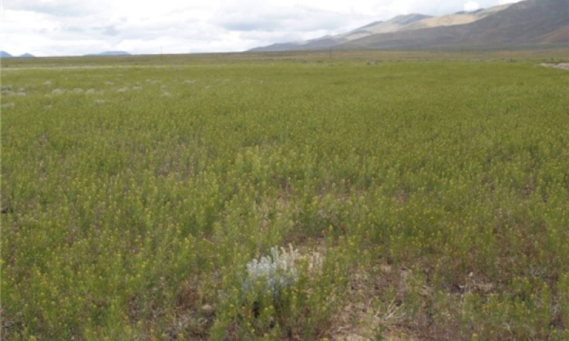
Annual precipitation typically ranges from 6 to 12 inches (15 to 30 cm) for most of the area. In the mountains however the precipitation may be up to 40 inches (101 cm). Most of the annual precipitation is from snow in the winter. In the spring and fall, rainfall occurs as high- intensity, convective thunderstorms.
Nevada is on the eastern, lee side of the Sierra Nevada Range; a massive mountain barrier that markedly influences the climate of the State. The prevailing winds are from the west. The warm moist air from the Pacific Ocean ascends the western slopes of the Sierra Range, the air cools, condenses and the moisture falls as precipitation. As the air descends the eastern slope, it is warmed by compression, and very little precipitation occurs. The effects of this mountain barrier are felt not only in the west but throughout the State. The result is the lowlands of Nevada are largely desert or steppes.
Ecological site concept
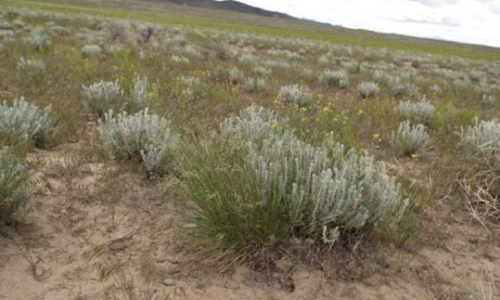
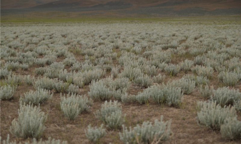
This ecological site is on fan piedmonts. Soils associated with this site are very deep, well drained and formed in alluvium derived from mixed rocks, loess and volcanic ash. The soil profile is characterized by an ochric epipedon, a sodium free surface, and moderately to strongly sodium effected subsoil. Soil textures are dominated by silt loam, ashy very fine silt loam, and/or ashy fine sandy loam. The soil temperature regime is mesic and the soil moisture regime is typic aridic.
The reference state is dominated by winterfat, bud sagebrush and Indian ricegrass.
Future field work in compare the soil characteristics and abiotic factors for all winterfat dominated ESCs (024XY004NV, 024XY011NV, 024XY014NV, 024XY059NV & 024XY011OR) in MRLA 24 and determine if they are one ESC.
Associated sites
| R024XY014NV |
COARSE SILTY 4-8 P.Z. This ecological site occurs on fan piedmonts. Soils associated with this site are very deep, well drained and formed in alluvium derived from mixed rocks, loess and volcanic ash. The soil profile is characterized by an ochric epipedon. The reference state is dominated by winterfat (KRLA2), bud sagebrush (ARSP5), and Indian ricegrass (ACHY). |
|---|---|
| R024XY020NV |
DROUGHTY LOAM 8-10 P.Z. Important abiotic factors contributing to the presence of this site include limited available soil moisture due to texture and precipitation zone. Vegetative cover is less than 25% and is dominated by deep-rooted, cool season perennial bunchgrasses and drought tolerant shrubs. Dominant species include Thurber’s needlegrass (ACTH7), Indian ricegrass (ACHY), Wyoming big sagebrush (ARTRW8), and spiny hopsage (GRSP). |
Similar sites
| R024XY059NV |
SILTY 8-10 P.Z. The soil profile is characterized by an ochric epipedon, a sodium free surface, and moderately to strongly sodium effected subsoil. More productive site Winterfat (KRLA2), Indian ricegrass (ACHY); does not occur on bolson floor. |
|---|---|
| R024XY060NV |
SHALLOW SILTY 8-10 P.Z. Soils are dominated by fine loams and find sands and have a strong vesicular horizon and very platy structure in the surface horizon. Shadscale saltbrush (ATCO) dominant plant; Bud sagebrush (ARSP5) & Greasewood (SAVE4) rare. |
| R024XY011NV |
SODIC FLAT 6-8 P.Z. Important abiotic factors include crusting & baking of the surface layer upon drying, inhibiting water infiltration and seedling emergence. Greasewood (SAVE4) dominant shrub; Shadscale saltbrush (ATCO) minor shrub. |
| R024XY014NV |
COARSE SILTY 4-8 P.Z. The soil profile is characterized by an ochric epipedon, a sodium free surface, and moderately to strongly sodium effected subsoil. More productive site Winterfat (KRLA2), Bud sagebrush (ARSP5); greater shrub diversity. |
| R024XY067NV |
SHALLOW SILTY 5-8 P.Z. The soil profile is characterized by an ochric epipedon, continuous weak cementation with in 20 inches, and coarse silty particle size control section. Shadscale saltbrush (ATCO) dominant shrub; less productive site. |
| R024XY022NV |
SODIC TERRACE 8-10 P.Z. Soils are characterized by a very low infiltration, an ochric epipedon, moderate to very strong alkalinity. Greasewood (SAVE4), Big sagebrush (ARTR2) codominant; more productive site. |
Table 1. Dominant plant species
| Tree |
Not specified |
|---|---|
| Shrub |
(1) Krascheninnikovia lanata |
| Herbaceous |
(1) Achnatherum hymenoides |


Click on box and path labels to scroll to the respective text.
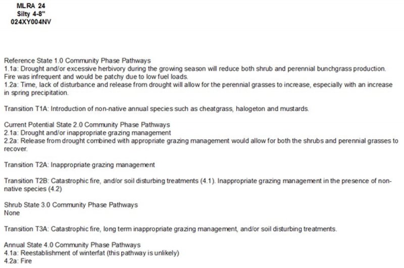
| T1A | - | Trigger: introduction of non-native invasive species, such as cheatgrass, mustards, poverty weed, halogeton and Russian thistle.Slow variables: changes in kinds of animals and their grazing patterns, drought and/or changes in fire history that altered recruitment rates of native species. Threshold: reduction in the herbaceous understory, changes in soil hydrology including infiltration and runoff. Non-native invasive species cannot be easily removed from the system and have the potential to significantly alter disturbance regimes from their historic range of variation. |
|---|---|---|
| T2A | - | Trigger: Fire or inadequate rest and recovery from defoliation during spring and/or early summer. Slow variables: long-term decrease in grass density and reduced native species (shrubs and grass) recruitment rates. Increased reproduction, cover and density of non-native invasive species. Threshold: loss of deep-rooted perennial bunchgrasses and loss of native shrubs reduces infiltration and increases runoff; this leads to reduced soil organic matter and soil moisture. Modified fire regime driven by non-native invasive annuals (changes in frequency, intensity, size and spatial variability of fire). |
| T3A | - | Trigger: Severe fire/ multiple fires, long term inappropriate grazing management, and/or soil disturbing treatments such as plowing. Slow variables: Increased production and cover of non-native annual species. Threshold: Increased, continuous fine fuels modify the fire regime by changing intensity, size and spatial variability of fires. Changes in plant community composition and spatial variability of vegetation due to the loss of perennial bunchgrasses and sagebrush truncate energy capture spatially and temporally thus impacting nutrient cycling and distribution. |
State 1 submodel, plant communities
| 1.1a | - | This pathway is a result of drought, insect or disease attack. The rare low intensity, patchy fire, or other disturbance that reduces overall plant cover. |
|---|---|---|
| 1.2a | - | This pathway is a result of recovery from drought and adequate rest and recovery from defoliation. |
State 2 submodel, plant communities
| 2.1a | - | This pathway is a result of prolonged drought, and inadequate rest and recovery from defoliation during the growing season which favors unpalatable shrub cover over perennial bunchgrass and winterfat cover. |
|---|---|---|
| 2.2a | - | This pathway is a result of a release from drought, adequate rest and recovery from defoliation and favorable climatic conditions which facilitates recovery of bunchgrasses, winterfat and associated shrub cover. |
State 3 submodel, plant communities
State 4 submodel, plant communities
| 4.1a | - | This pathway is a result of reestablishment of winterfat cover. This pathway is unlikely due to the impact of annual non-native species on the establishment and growth of winterfat seedlings. |
|---|---|---|
| 4.2a | - | This pathway is a result of Wildfire. |