
Natural Resources
Conservation Service
Ecological site R024XY031NV
SHALLOW CALCAREOUS LOAM 10-14 P.Z.
Last updated: 3/07/2025
Accessed: 04/10/2026
General information
Provisional. A provisional ecological site description has undergone quality control and quality assurance review. It contains a working state and transition model and enough information to identify the ecological site.
MLRA notes
Major Land Resource Area (MLRA): 024X–Humboldt Basin and Range Area
Major land resource area (MLRA) 24, the Humboldt Area, covers an area of approximately 8,115,200 acres (12,680 sq. mi.). It is found in the Great Basin Section of the Basin and Range Province of the Intermontane Plateaus. Elevations range from 3,950 to 5,900 feet (1,205 to 1,800 meters) in most of the area, some mountain peaks are more than 8,850 feet (2,700 meters).
A series of widely spaced north-south trending mountain ranges are separated by broad valleys filled with alluvium washed in from adjacent mountain ranges. Most valleys are drained by tributaries to the Humboldt River. However, playas occur in lower elevation valleys with closed drainage systems. Isolated ranges are dissected, uplifted fault-block mountains. Geology is comprised of Mesozoic and Paleozoic volcanic rock and marine and continental sediments. Occasional young andesite and basalt flows (6 to 17 million years old) occur at the margins of the mountains. Dominant soil orders include Aridisols, Entisols, Inceptisols and Mollisols. Soils of the area are generally characterized by a mesic soil temperature regime, an aridic soil moisture regime and mixed geology. They are generally well drained, loamy and very deep.
Annual precipitation ranges from 6 to 12 inches (15 to 30 cm) for most of the area, but can be as much as 40 inches (101 cm) in the mountain ranges. The majority of annual precipitation occurs as snow in the winter. Rainfall occurs as high-intensity, convective thunderstorms in the spring and fall.
Ecological site concept
This ecological site is on summits and side slopes of hills and mountains on all exposures. Soils are shallow to moderately deep, well drained and formed in residuum derived from chert, argillite and other mixed parent material. The soil profile is characterized by an ochric epipedon and greater than 35 percent rock fragments by volume.
Important abiotic factors contributing to the presence of this site include low available water holding capacity and the presence of secondary carbonates in the soil profile.
Associated sites
| R024XY021NV |
Loamy Slope 12-14 P.Z. This site is on lava plateaus and tablelands. Soils are deep, well drained and formed in residuum/colluvium. They are characterized by an ochric epipedon and an argillic horizon. The subsoil is a strongly contrasting very gravelly or cobbly clay loam. An abrupt boundary occurs between the surface layer and subsoil. |
|---|---|
| R024XY030NV |
SHALLOW CALCAREOUS LOAM 8-10 P.Z. This ecological site is on fan remnants. The soils are shallow to a duripan, well drained and formed in loess with a component of volcanic ash and alluvium derived from mixed parent material. The soil profile is characterized by an ochric epipedon, effervescence throughout the profile and less than 35 percent rock fragments by volume. |
Similar sites
| R024XY042NV |
STEEP GRAVELLY LOAM 14+ P.Z. Idaho fescue (FEID) dominant grass; more productive site. |
|---|---|
| R024XY030NV |
SHALLOW CALCAREOUS LOAM 8-10 P.Z. Thurber's needlegrass (ACTH7)- Indian ricegrass (ACHY) codominant grasses; less productive site. |
| R024XY016NV |
Mountain Ridge Idaho fescue (FEID) dominant grass; less productive site. |
Table 1. Dominant plant species
| Tree |
Not specified |
|---|---|
| Shrub |
(1) Artemisia nova |
| Herbaceous |
(1) Pseudoroegneria spicata |
Physiographic features
This site is on summits and side slopes of mountains on all aspects. Slopes range from 2 to 75 percent, but slope gradients of 15 to 50 percent are typical. Elevations range from 4900 to 8000 feet (1493 to 2438m).
Table 2. Representative physiographic features
| Landforms |
(1)
Mountain
(2) Hillside or mountainside |
|---|---|
| Runoff class | High to very high |
| Flooding frequency | None |
| Elevation | 4,900 – 8,000 ft |
| Slope | 2 – 75% |
| Water table depth | 72 in |
| Aspect | W, NW, N, NE, E, SE, S, SW |
Climatic features
The climate associated with this site is semiarid and characterized by cool, moist winters and warm, dry summers. Average annual precipitation is 10 to 14 inches (25 to 36cm). Mean annual air temperature is 41 to 45 degrees F. The average growing season is about 80 to 100 days.
Table 3. Representative climatic features
| Frost-free period (characteristic range) | 77 days |
|---|---|
| Freeze-free period (characteristic range) | 102 days |
| Precipitation total (characteristic range) | 8 in |
| Frost-free period (actual range) | 77 days |
| Freeze-free period (actual range) | 102 days |
| Precipitation total (actual range) | 8 in |
| Frost-free period (average) | 77 days |
| Freeze-free period (average) | 102 days |
| Precipitation total (average) | 8 in |
Figure 1. Monthly precipitation range
Figure 2. Monthly minimum temperature range
Figure 3. Monthly maximum temperature range
Figure 4. Monthly average minimum and maximum temperature
Figure 5. Annual precipitation pattern
Figure 6. Annual average temperature pattern
Climate stations used
-
(1) WINNEMUCCA MUNI AP [USW00024128], Winnemucca, NV
Influencing water features
There are no influencing water features associated with this site.
Soil features
The soils associated with this site are shallow to a duripan or bedrock, well drained and formed in residuum and colluvium from mixed parent material. The soil profile is characterized by an ochric epipedon, 30 to over 50 percent gravel and cobbles by volume and the presence of secondary carbonate accumulation. The reaction ranges from moderately or strongly alkaline. The available water capacity is very low to low. The soil series associated with this site include: Anowell, Cleavmor, Coff, Elhina, Fenelon, Pamison, Quopant, Tecomar, Trinidad, and Wiskan.
Table 4. Representative soil features
| Parent material |
(1)
Colluvium
–
limestone
(2) Residuum – dolomite |
|---|---|
| Surface texture |
(1) Extremely gravelly silt loam (2) Extremely stony silt loam (3) Extremely cobbly silt loam |
| Family particle size |
(1) Loamy |
| Drainage class | Well drained |
| Permeability class | Slow to moderate |
| Soil depth | 5 – 20 in |
| Surface fragment cover <=3" | 19 – 61% |
| Surface fragment cover >3" | 35% |
| Available water capacity (0-40in) |
0.9 – 5.5 in |
| Calcium carbonate equivalent (0-40in) |
80% |
| Electrical conductivity (0-40in) |
4 mmhos/cm |
| Sodium adsorption ratio (0-40in) |
12 |
| Soil reaction (1:1 water) (0-40in) |
6.6 – 9 |
| Subsurface fragment volume <=3" (Depth not specified) |
12 – 62% |
| Subsurface fragment volume >3" (Depth not specified) |
48% |
Ecological dynamics
An ecological site is the product of all the environmental factors responsible for its development and it has a set of key characteristics that influence a site’s resilience to disturbance and resistance to invasives. Key characteristics include 1) climate (precipitation, temperature), 2) topography (aspect, slope, elevation, and landform), 3) hydrology (infiltration, runoff), 4) soils (depth, texture, structure, organic matter), 5) plant communities (functional groups, productivity), and 6) natural disturbance regime (fire, herbivory, etc.) (Caudle 2013). Biotic factors that influence resilience include site productivity, species composition and structure, and population regulation and regeneration (Chambers et al. 2013).
This ecological site is dominated by deep-rooted cool season, perennial bunchgrasses and long-lived shrubs (50+ years) with high root to shoot ratios. The dominant shrubs usually root to the full 156 depth of the winter-spring soil moisture recharge, which ranges from 1.0 to over 3.0 m (Dobrowolski et al. 1990). Root length of mature sagebrush plants was measured to a depth of 2 meters in alluvial soils in Utah (Richards and Caldwell 1987). However, community types with black sagebrush as the dominant shrub were found to have soil depths and thus available rooting depths of 71 to 81 cm in a study in northeast Nevada (Jensen 1990). These shrubs have a flexible generalized root system with development of both deep taproots and laterals near the surface (Comstock and Ehleringer 1992).
Periodic drought regularly influences sagebrush ecosystems and drought duration and severity has increased throughout the 20th century in much of the Intermountain West. Major shifts away from historical precipitation patterns have the greatest potential to alter ecosystem function and productivity. Species composition and productivity can be altered by the timing of precipitation and water availability with the soil profile (Bates et al. 2006).
Native insect outbreaks are also important drivers of ecosystem dynamics in sagebrush communities. Climate is generally believed to influence the timing of insect outbreaks especially a sagebrush defoliator, Aroga moth (Aroga websteri). Aroga moth infestations have occurred in the Great Basin in the 1960s, early 1970s, and is ongoing in Nevada since 2004 (Bentz, et al 2008). Thousands of acres of big sagebrush have been impacted, with partial to complete die-off observed. Aroga moth can partially or entirely kill individual plants or entire stands of big sagebrush (Artemisia tridentata spp.) (Furniss and Barr 1975), but the research is inconclusive of the damage sustained by black sagebrush populations.
Black sagebrush is generally long-lived; therefore it is not necessary for new individuals to recruit every year for perpetuation of the stand. Infrequent large recruitment events and simultaneous low, continuous recruitment is the foundation of population maintenance (Noy-Meir 1973). Survival of the seedlings is dependent on adequate moisture conditions.
The perennial bunchgrasses that are dominant on this site include bluebunch wheatgrass, Thurber’s needlegrass and Indian ricegrass. These species generally have somewhat shallower root systems than the shrubs, but root densities are often as high as or higher than those of shrubs in the upper 0.5 m but taper off more rapidly than shrubs. Differences in root depth distributions between grasses and shrubs result in resource partitioning in these shrub/grass systems.
The Great Basin sagebrush communities have high spatial and temporal variability in precipitation both among years and within growing seasons. Nutrient availability is typically low but increases with elevation and closely follows moisture availability. The invasibility of plant communities is often linked to resource availability. Disturbance can decrease resource uptake due to damage or mortality of the native species and depressed competition or can increase resource pools by the decomposition of dead plant material following disturbance. The invasion of sagebrush communities by cheatgrass (Bromus tectorum) has been linked to disturbances (fire, abusive grazing) that have resulted in fluctuations in resources (Chambers et al. 2007). The introduction of annual weedy species, like cheatgrass, may cause an increase in fire frequency and eventually lead to an annual state. Conversely, as fire frequency decreases, sagebrush will increase and with inappropriate grazing management the perennial bunchgrasses and forbs may be reduced.
This ecological site has low to moderate resilience to disturbance and resistance to invasion. Increased resilience increases with elevation, aspect, increased precipitation and increased nutrient availability. Four possible alternative stable states have been identified for this site.
Fire Ecology:
Fire is not a major ecological component of these community types (Winward 2001), and would be infrequent. Fire return intervals have been estimated at 100 to 200 years (Kitchen and McArthur 2007); however, fires were probably patchy due to the low productivity of these sites. Black sagebrush plants have no morphological adaptations for surviving fire and must reestablish from seed following fire (Wright et al. 1979). Since black sagebrush has a transient soil seed bank, the ability of black sagebrush to establish after fire is mostly dependent on the amount of seed deposited in the seed bank the year before the fire. Seeds typically do not persist in the soil for more than 1 growing season (Beetle 1960). A few seeds may remain viable in soil for 2 years (Meyer 2008); however, even in dry storage, black sagebrush seed viability has been found to drop rapidly over time, from 81% to 1% viability after 2 and 10 years of storage, respectively (Stevens et al. 1981). Thus, repeated frequent fires can eliminate black sagebrush from a site, however black sagebrush in zones receiving 12 to 16 inches of annual precipitation have been found to have greater fire survival (Boltz 1994). In lower precipitation zones shadscale (Atriplex confertifolia), spiny hopsage (Grayia spinosa) and rabbitbrush (Chrysothamnus viscidiflorus or Ericameria nauseosa) may become the dominant shrub species following fire, often with an understory of Sandberg bluegrass and/or cheatgrass and other weedy species. Sandberg bluegrass has been found to increase following fire likely due to its low stature and productivity (Daubenmire 1975).
Thurber’s needlegrass reproduces from seed and tillers; however, following fire the reestablishment of the needlegrass component is largely seed dependent (Hironaka et al. 1983). Reestablishment on burned sites has been found to be relatively slow due to low germination and seedling vigor. In a controlled environment study, Thurber’s needlegrass was found to have a maximum germination rate of 25% under ideal conditions (Martens et al. 1994). Fire-caused mortality of Thurber’s needlegrass varies by both plant size and season (Young et al. 1976). Wright and others (1979) concluded that Thurber’s needlegrass is probably the least fire-resistant needlegrass, largely due to its densely tufted stems. Aboveground vegetation is often consumed by fire and burning has been found to decrease Thurber’s needlegrass vegetative and reproductive vigor (Uresk et al. 1976). The seasonal response to burning is also important in determining the extent of damage by fire with growing season burning causing greater mortality (50 to 70 percent) than dormant season burning (Young et al. 1976). Regeneration of Thurber’s needlegrass is often dependent on competition from other species. Cheatgrass has been found to be a highly successful competitor with seedlings of this needlegrass and may preclude reestablishment (Evans and Young 1978). Repeated frequent fire in the black sagebrush – Thurber’s needlegrass community will eliminate both species from the site and facilitate the establishment of an annual grass and weed community with varying amounts of Sandberg bluegrass, shadscale, spiny hopsage and rabbitbrush.
Indian ricegrass commonly found on these sites, is fairly fire tolerant (Wright 1985), which is likely due to its low culm density and below ground plant crowns. Indian ricegrass has been found to reestablish on burned sites through seed dispersed from adjacent unburned areas (Young 1983, West 1994). Thus the presence of surviving, seed producing plants is necessary for reestablishment of Indian ricegrass. Grazing management following fire to promote seed production and establishment of seedlings is important.
Utah juniper (Juniperus osteosperma) and singleleaf pinyon (Pinus monophylla) can invade these sites from nearby seed sources. These trees are usually killed by fire, and is most vulnerable to fire when it is under four feet tall (Bradley et al. 1992). Larger trees, because they have foliage farther from the ground and thicker bark, can survive low severity fires but mortality does occur when 60% or more of the crown is scorched (Bradley et al. 1992).
With the low production of the understory vegetation, high severity fires within this plant community were not likely and rarely became crown fires (Bradley et al. 1992, Miller and Tausch 2000). Tree density on this site increases with grazing management that favors the removal of fine fuels and management focused on fire suppression. With an increase of cheatgrass in the understory, fire severity is likely to increase.
With an extended fire return interval, eventually, singleleaf pinyon and Utah juniper will dominate the site and black sagebrush will be severely reduced along with the herbaceous understory. A few perennial bunchgrasses and mat-forming forbs may remain underneath trees. The potential for soil erosion increases as the woodland matures and the understory plant community cover declines.Utah juniper reestablishes by seed from nearby seed source or surviving seeds. Utah juniper begins to produce seed at about 30 years old (Bradley et al. 1992). Seeds establish best through the use of a nurse plant such as sagebrush and rabbitbrush (Everett and Ward 1984,Tausch and West 1988, Bradley et al. 1992). Utah juniper woodlands reach mature stage between 85 to 150 years after fire (Barney and Frischknecht 1974, Tausch and West 1988).
State and transition model

Figure 7. Legend 2018
More interactive model formats are also available.
View Interactive Models
More interactive model formats are also available.
View Interactive Models
Click on state and transition labels to scroll to the respective text
Ecosystem states
State 1 submodel, plant communities
State 2 submodel, plant communities
State 3 submodel, plant communities
State 4 submodel, plant communities
State 5 submodel, plant communities
State 1
Reference
The Reference State is a representative of the natural range of variability under pristine conditions. The Reference State has three general community phases; a shrub-grass dominant phase, a shrub dominant phase and a grass dominate phase. State dynamics are maintained by interactions between climatic patterns and disturbance regimes. Negative feedbacks enhance ecosystem resilience and contribute to the stability of the state. These include the presence of all structural and functional groups, low fine fuel loads, and retention of organic matter and nutrients. Plant community phase changes are primarily driven by fire, periodic drought and/or insect or disease attack. Due to the nature and extent of disturbance in this site, all three plant community phases would likely occur in a mosaic across the landscape.
Community 1.1
Shrub-Grass dominanted Plant Community
The reference plant community is dominated by black sagebrush, bluebunch wheatgrass and Thurber's needlegrass. Idaho fescue is found on those sites having a more favorable water balance, typically at higher elevations on north-facing slopes. Potential vegetative composition is about 50 percent grasses, 10 percent forbs and 40 percent shrubs.
Figure 8. Annual production by plant type (representative values) or group (midpoint values)
Table 5. Annual production by plant type
| Plant type | Low (lb/acre) |
Representative value (lb/acre) |
High (lb/acre) |
|---|---|---|---|
| Grass/Grasslike | 150 | 250 | 350 |
| Shrub/Vine | 120 | 200 | 280 |
| Forb | 30 | 50 | 70 |
| Total | 300 | 500 | 700 |
Community 1.2
Post-fire Plant Community
This community phase is characteristic of a post-disturbance, early seral community phase. Bluebunch wheatgrass, Thurber’s needlegrass, Indian ricegrass and other perennial bunchgrasses dominate. Sprouting shrubs such as Douglas’ rabbitbrush, spiny hopsage, and shadscale may increase. Black sagebrush could still be present in unburned patches. Forbs may increase post-fire but will likely return to pre-burn levels within a few years. Sandberg bluegrass will generally increase following fire, but may decrease in below-average years of precipitation. Sandberg bluegrass may also increase.
Community 1.3
Shrub-dominanted Plant Community
Black sagebrush increases in the absence of disturbance. Decadent sagebrush dominates the overstory and the deep-rooted perennial bunchgrasses in the understory are reduced either from competition with shrubs and/or herbivory. Sandberg bluegrass may increase in the understory and become the dominant grass on the site.
Pathway 1.1a
Community 1.1 to 1.2
A low severity fire would decrease the overstory of sagebrush and allow the understory perennial grasses to increase. Fires are typically low severity resulting in a mosaic pattern due to low fuel loads. A fire following an unusually wet spring facilitating an increase in fine fuels may be more severe and reduce sagebrush cover to trace amounts.
Pathway 1.1b
Community 1.1 to 1.3
Absence of disturbance over time, significant herbivory, chronic drought or combinations of these would allow the sagebrush overstory to increase and dominate the site. This will generally cause a reduction in perennial bunch grasses; however Sandberg bluegrass may increase in the understory depending on the grazing management. Heavy spring grazing will favor an increase in sagebrush.
Pathway 1.2a
Community 1.2 to 1.1
Time and lack of disturbance will allow sagebrush to re-establish.
Pathway 1.3a
Community 1.3 to 1.1
A low severity fire, herbivory or combinations will reduce the sagebrush overstory and create a sagebrush/grass mosaic.
Pathway 1.3b
Community 1.3 to 1.2
Fire will decrease or eliminate the overstory of sagebrush and allow the perennial bunchgrasses to dominate the site. Fires will typically be high intensity in this community phase due to the dominance of sagebrush resulting in removal of the overstory shrub community.
State 2
Current Potential
This state is similar to the Reference State 1.0 and has three similar community phases. Ecological function has not changed in this state, but the resiliency of the state has been reduced by the presence of invasive weeds. These non-native species can be highly flammable, and promote fire where historically fire had been infrequent. Negative feedbacks enhance ecosystem resilience and contribute to the stability of the state. These include the presence of all structural and functional groups, low fine fuel loads and retention of organic matter and nutrients. Positive feedbacks decrease ecosystem resilience and stability of the state. These include the non-natives high seed output, persistent seed bank, rapid growth rate, ability to cross pollinate and adaptations for seed dispersal.
Community 2.1
Shrub-Grass dominanted Community Phase
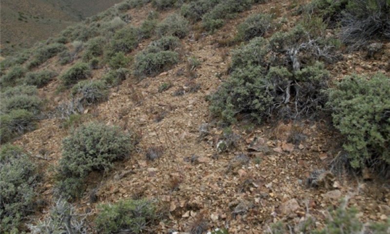
Figure 9. T. Stringham 6/2010 NV775 MU1216
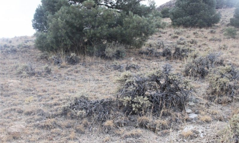
Figure 10. Shallow Calcareous Loam 10-14 P.Z. Phase 2.1 T. Stringham June 2010 NV775, MU1216
This community phase is compositionally similar to the Reference State Community Phase 1.1 with the presence of non-native species in trace amounts. This community is dominated by black sagebrush in the overstory with bluebunch wheatgrass, Thurber’s needlegrass and Indian ricegrass dominant in the understory.
Community 2.2
Post-fire Community Phase
This community phase is characteristic of a post-disturbance, early seral community where annual non-native species are present. Sagebrush is present in trace amounts; perennial bunchgrasses dominate the site. Depending on fire severity patches of intact sagebrush may remain. Rabbitbrush or other sprouting shrubs may be increasing. Annual non-native species are stable or increasing within the community. Sandberg bluegrass will generally increase following fire, but may decrease in below-average years of precipitation. Annual non-native species generally respond well after fire and may be stable or increasing within the community.
Community 2.3
Shrub-dominated Community Phase (At-Risk)
Black sagebrush dominates the overstory and perennial bunchgrasses in the understory are reduced, either from competition with shrubs or from inappropriate grazing, or from both. Rabbitbrush may be a significant component. Sandberg bluegrass may increase and become co-dominant with deep rooted bunchgrasses. Annual non-native species may be stable or increasing due to lack of competition with perennial bunchgrasses. This site is susceptible to further degradation from grazing, drought, and fire. This community is at risk of crossing a threshold to either Shrub State 3.0 (grazing or fire) or Annual State 4.0 (fire).
Pathway 2.1a
Community 2.1 to 2.2
A low severity fire would decrease the overstory of sagebrush and allow the understory perennial grasses to increase. Fires are typically low severity resulting in a mosaic pattern due to low fuel loads. A fire following an unusually wet spring or a change in management favoring an increase in fine fuels may be more severe and reduce sagebrush cover to trace amounts. Annual non-native species are likely to increase after fire. Brush treatments with minimal soil disturbance may also reduce the sagebrush overstory and allow an increase in perennial grasses.
Pathway 2.1b
Community 2.1 to 2.3
Absence of disturbance over time, chronic drought, inappropriate grazing management or combinations of these would allow the sagebrush overstory to increase and dominate the site. Inappropriate grazing management reduces the perennial bunchgrass understory; conversely Sandberg bluegrass may increase in the understory.
Pathway 2.2a
Community 2.2 to 2.1
Absence of disturbance over time and/or grazing management that favors the establishment and growth of sagebrush allows the shrub component to recover. The establishment of black sagebrush can take many years.
Pathway 2.3a
Community 2.3 to 2.1
Grazing management that reduces shrubs will allow the perennial bunchgrasses in the understory to increase. Heavy late-fall/winter grazing may cause mechanical damage to sagebrush promoting the perennial bunchgrass understory. Brush treatments with minimal soil disturbance will also decrease sagebrush and release the perennial understory. Annual non-native species are present and may increase in the community. A low severity fire would decrease the overstory of sagebrush and allow the understory perennial grasses to increase. Due to low fuel loads in this State, fires will likely be small creating a mosaic pattern.
Conservation practices
| Brush Management | |
|---|---|
| Prescribed Grazing |
Pathway 2.3b
Community 2.3 to 2.2
Fire will decrease or eliminate the overstory of sagebrush and allow the perennial bunchgrasses to dominate the site. Fires will typically be high intensity due to the dominance of sagebrush in this phase, resulting in removal of the overstory shrub community. Annual non-native species respond well to fire and may increase post-burn.
State 3
Shrub
This state has two community phases, one that is characterized by a black sagebrush overstory and the other with a shadscale or rabbitbrush overstory with a Sandberg bluegrass understory. The site has crossed a biotic threshold and site processes are being controlled by shrubs. Bare ground has increased and pedestalling of grasses may be excessive.
Community 3.1
Shrub-dominated Community Phase
Figure 11. Shallow Calc Loam 10-14 P.Z. Phase 3.1 T. Stringham June 2010
Black sagebrush dominates overstory while Sandberg bluegrass dominates the understory. Deep-rooted perennial bunchgrasses have significantly declined. Annual non-native species may be present. Bare ground and soil redistribution may be increasing. If present on the site, Utah juniper and/or singleleaf pinyon are increasing. The community phase may be at risk of transitioning into an Annual State.
Community 3.2
Post-fire Community Phase (At-Risk)
Shadscale and/or rabbitbrush dominate the overstory. Broom snakeweed may be present to increasing. Annual non-native species may be increasing and bare ground is significant. This site is at risk for an increase in invasive annual weeds.
Pathway 3.1a
Community 3.1 to 3.2
Fire reduces black sagebrush to trace amounts and allows for sprouting shrubs such as rabbitbrush to dominate. Shadscale may also establish post-fire and become dominate. Inappropriate or excessive sheep grazing could also reduce cover of sagebrush and allow shadscale or sprouting shrubs to dominate the community. Brush treatments with minimal soil disturbance would facilitate sprouting shrubs and Sandberg bluegrass.
Conservation practices
| Brush Management |
|---|
Pathway 3.2a
Community 3.2 to 3.1
Time and lack of disturbance and/or grazing management that favors the establishment and growth of sagebrush allows for the shrub component to recover.
State 4
Annual
This state has two community phases; one dominated by annual non-native species and the other is a shrub dominated site. This state is characterized by the dominance of annual non-native species such as cheatgrass and tansy mustard in the understory. Sagebrush and/or rabbitbrush may dominate the overstory. Annual non-native species and squirreltail dominate the understory.
Community 4.1
Annual non-native plants
Annual non-native plants such as cheatgrass or tansy mustard dominate the site. This phase may have seeded species present if resulting from a failed seeding attempt.
Community 4.2
Shrub/Annuals
Black sagebrush and/or rabbitbrush dominate the overstory with annual non-native species, likely cheatgrass, dominating the understory. Trace amounts of desirable bunchgrasses may be present.
Pathway 4.1a
Community 4.1 to 4.2
Time and lack of disturbance. Occurrence of this pathway is unlikely when wildfire occurs within a 5 to 10 year interval.
Pathway 4.2a
Community 4.2 to 4.1
Fire
State 5
Tree
This state has two community phases that are characterized by the dominance of Utah juniper and singleleaf pinyon in the overstory. Black sagebrush and perennial bunchgrasses may still be present, but they are no longer controlling site resources. Soil moisture, soil nutrients and soil organic matter distribution and cycling have been spatially and temporally altered.
Community 5.1
Tree-shrub
Utah juniper and/or singleleaf pinyon dominate the overstory and site resources. Trees are actively growing with noticeable leader growth. The shrub and grass understory is reduced. Sagebrush is stressed and dying. Trace amounts of deep-rooted bunchgrasses may be found under tree canopies with forbs in the interspaces. Annual non-native species are present under tree canopies. Bare ground areas are large and connected.
Community 5.2
Tree dominant
Utah juniper and/or singleleaf pinyon dominate the site and tree leader growth is minimal; annual non-native species may be the dominant understory species and will typically be found under the tree canopies. Trace amounts of sagebrush may be present, however dead skeletons will be more numerous than living sagebrush. Deep-rooted bunchgrasses may or may not be present. Mat-forming forbs may be present in trace amounts. Bare ground areas are large and connected and soil redistribution may be occurring.
Pathway 5.1a
Community 5.1 to 5.2
Time and lack of disturbance or management action allows Utah juniper and/or singleleaf pinyon to further mature and dominate site resources.
Conservation practices
| Brush Management |
|---|
Transition T1A
State 1 to 2
Trigger: Introduction of non-native annual plants. Slow variables: Over time the annual non-native plants will increase within the community. Threshold: Any amount of introduced non-native species causes an immediate decrease in the resilience of the site. Annual non-native species cannot be easily removed from the system and have the potential to significantly alter disturbance regimes from their historic range of variation.
Transition T2A
State 2 to 3
Trigger: To Community Phase 3.1: Inappropriate cattle/horse grazing will decrease or eliminate deep rooted perennial bunchgrasses, increase Sandberg bluegrass and favor shrub growth and establishment. To Community Phase 3.2: Severe fire will remove sagebrush overstory, decrease perennial bunchgrasses and enhance Sandberg bluegrass. Soil disturbing brush treatments and/or inappropriate sheep grazing will reduce sagebrush and potentially increase sprouting shrubs and Sandberg bluegrass. Slow variables: Long-term decrease in deep-rooted perennial grass density and/or black sagebrush.
Transition T2B
State 2 to 4
Trigger: Catastrophic fire likely in at risk community phase 2.3, or soil surface disturbance. Slow variables: Increased production and cover of non-native annual species. Threshold: Loss of deep-rooted perennial bunchgrasses and shrubs changes energy and nutrient capture and cycling both spatially and temporally within the community. Increased, continuous fine fuels modify the fire regime by changing intensity, size and spatial variability of fires.
Transition T3A
State 3 to 4
Fire and/or soil disturbing treatments (i.e. failed restoration attempts) to 4.0
Transition T3B
State 3 to 5
Time and lack of disturbance allows for maturation of tree community, may be coupled with inappropriate grazing management (5.1).
Transition T5A
State 5 to 4
Catastrophic fire
Additional community tables
Table 6. Community 1.1 plant community composition
| Group | Common name | Symbol | Scientific name | Annual production (lb/acre) | Foliar cover (%) | |
|---|---|---|---|---|---|---|
|
Grass/Grasslike
|
||||||
| 1 | Primary Perennial Grasses | 160–340 | ||||
| bluebunch wheatgrass | PSSPS | Pseudoroegneria spicata ssp. spicata | 100–175 | – | ||
| Thurber's needlegrass | ACTH7 | Achnatherum thurberianum | 50–125 | – | ||
| Indian ricegrass | ACHY | Achnatherum hymenoides | 10–40 | – | ||
| 2 | Secondary Perennial Grasses | 10–75 | ||||
| Webber needlegrass | ACWE3 | Achnatherum webberi | 3–15 | – | ||
| squirreltail | ELEL5 | Elymus elymoides | 3–15 | – | ||
| Idaho fescue | FEID | Festuca idahoensis | 3–15 | – | ||
| needle and thread | HECO26 | Hesperostipa comata | 3–15 | – | ||
| basin wildrye | LECI4 | Leymus cinereus | 3–15 | – | ||
| bluegrass | POA | Poa | 3–15 | – | ||
|
Forb
|
||||||
| 3 | Perennial Forbs | 25–75 | ||||
| aster | ASTER | Aster | 3–25 | – | ||
| milkvetch | ASTRA | Astragalus | 3–25 | – | ||
| tapertip hawksbeard | CRAC2 | Crepis acuminata | 3–25 | – | ||
| buckwheat | ERIOG | Eriogonum | 3–25 | – | ||
| lupine | LUPIN | Lupinus | 3–25 | – | ||
| phlox | PHLOX | Phlox | 3–25 | – | ||
|
Shrub/Vine
|
||||||
| 4 | Primary Shrubs | 125–175 | ||||
| black sagebrush | ARNO4 | Artemisia nova | 125–175 | – | ||
| 5 | Secondary Shrubs | 10–50 | ||||
| Utah serviceberry | AMUT | Amelanchier utahensis | 5–15 | – | ||
| yellow rabbitbrush | CHVI8 | Chrysothamnus viscidiflorus | 5–15 | – | ||
| spiny hopsage | GRSP | Grayia spinosa | 5–15 | – | ||
| winterfat | KRLA2 | Krascheninnikovia lanata | 5–15 | – | ||
| snowberry | SYMPH | Symphoricarpos | 5–15 | – | ||
Interpretations
Animal community
Livestock Interpretations:
This site has limited value for livestock grazing, due to steep slopes. Grazing management should be keyed to perennial grass and palatable shrub production. Bluebunch wheatgrass is considered one of the most important forage grass species on western rangelands for livestock. Although bluebunch wheatgrass can be a crucial source of forage, it is not necessarily the most highly preferred species. Thurber’s needlegrass species begin growth early in the year and remain green throughout a relatively long growing season. This pattern of development enables animals to use Thurber’s needlegrass when many other grasses are unavailable. Cattle prefer Thurber’s needlegrass in early spring before fruits have developed as it becomes less palatable when mature. Thurber’s needlegrasses are grazed in the fall only if the fruits are softened by rain. Indian ricegrass is highly palatable to all classes of livestock in both green and cured condition. It supplies a source of green feed before most other native grasses have produced much new growth. In winter, at lower elevations, black sagebrush is heavily utilized by domestic sheep.
Stocking rates vary over time depending upon season of use, climate variations, site, and previous and current management goals. A safe starting stocking rate is an estimated stocking rate that is fine tuned by the client by adaptive management through the year and from year to year.
Wildlife Intwerpretations:
Bluebunch wheatgrass is considered one of the most important forage grass species on western rangelands for wildlife. Bluebunch wheatgrass does not generally provide sufficient cover for ungulates, however, mule deer are frequently found in bluebunch-dominated grasslands. Thurber needlegrass is valuable forage for wildlife. Indian ricegrass is eaten by pronghorn in moderate amounts whenever available. A number of heteromyid rodents inhabiting desert rangelands show preference for seed of Indian ricegrass. Indian ricegrass is an important component of jackrabbit diets in spring and summer. In Nevada, Indian ricegrass may even dominate jackrabbit diets during the spring through early summer months. Indian ricegrass seed provides food for many species of birds. Doves, for example, eat large amounts of shattered Indian ricegrass seed lying on the ground. Black sagebrush is a significant browse species within the Intermountain region. It is especially important on low elevation winter ranges in the southern Great Basin, where extended snow free periods allow animal’s access to plants throughout most of the winter. In these areas it is heavily utilized by pronghorn and mule deer. Sagebrush-grassland communities provide critical sage-grouse breeding and nesting habitats. Sagebrush is a crucial component of their diet year-round, and sage-grouse select sagebrush almost exclusively for cover.
Hydrological functions
Runoff is medium to very high. Permeability is slow to moderate. Hydrologic soil groups are B, C, and D. Rills are none to rare. Rock fragments armor the surface. Water flow patterns are few and can be expected in areas subjected to summer convection storms or rapid snowmelt. Pedestals are none to rare. Occurrence is usually limited to areas of water flow patterns. Frost heaving of shallow rooted plants should not be considered a "normal" condition. Perennial herbaceous plants (especially deep-rooted bunchgrasses [i.e., bluebunch wheatgrass & Thurber's needlegrass]) slow runoff and increase infiltration. Shrub canopy and associated litter break raindrop impact.
Recreational uses
Aesthetic value is derived from the diverse floral and faunal composition and the colorful flowering of wild flowers and shrubs during the spring and early summer. This site offers rewarding opportunities to photographers and for nature study. This site is used for hiking and has potential for upland and big game hunting.
Other products
Indian ricegrass was traditionally eaten by some Native Americans. The Paiutes used seed as a reserve food source.
Other information
Black sagebrush is an excellent species to establish on sites where management objectives include restoration or improvement of domestic sheep, pronghorn, or mule deer winter range.
Supporting information
Inventory data references
NASIS soil component data.
Other references
Barney, M. A. and N. C. Frischknecht. 1974. Vegetation Changes following Fire in the Pinyon-Juniper Type of West-Central Utah. Journal of Range Management 27:91-96.
Bates, J. D., T. Svejcar, R. F. Miller, and R. A. Angell. 2006. The effects of precipitation timing on sagebrush steppe vegetation. Journal of Arid Environments 64:670-697.
Beale, D.M. and A.D. Smith. 1970. Forage use, water consumption, and productivity of pronghorn antelope in western Utah. Journal of Wildlife Management 34(3):570-582
Beetle, A.A. 1960. A study of sagebrush: The section Tridentatae of Artemisia. Bulletin 368. Laramie, WY: University of Wyoming, Agricultural Experiment Station. 83 p.
Bentz, B., D. Alston, and T. Evans. 2008. Great Basin Insect Outbreaks. In: J. Chambers, N. Devoe, A. Evenden [eds]. Collaborative Management and Research in the Great Basin -- Examining the issues and developing a framework for action Gen. Tech. Rep. RMRS-GTR-204. U.S. Department of Agriculture, Forest Service, Rocky Mountain Research Station, Fort Collins, CO. p. 45-48
Boltz, M. 1994. Factors influencing postfire sagebrush regeneration in south-central Idaho. In: Monsen, S.B. and S.G. Kitchen (compilers). Proceedings--ecology and management of annual rangelands; 1992 May 18-22; Boise, ID. Gen. Tech. Rep. INT-GTR-313. Ogden, UT: U.S. Department of Agriculture, Forest Service, Intermountain Research Station: Pgs 281-290.
Booth, D. T., C. G. Howard, and C. E. Mowry. 2006. 'Nezpar' Indian ricegrass: description, justification for release, and recommendations for use. Rangelands Archives 2:53-54.
Bradley, A.F., N.V. Noste, and W.C. Fischer. 1992. Fire ecology of forests and woodlands in Utah. Gen. Tech. Rep. INT-287. Ogden, UT. U.S. Department of Agriculture, Forest Service, Intermountain Research Station. 128 p.
Caudle, D., J. DiBenedetto, M. Karl, H. Sanchez, and C. Talbot. 2013. Interagency ecological site handbook for rangelands. Available at: http://jornada.nmsu.edu/sites/jornada.nmsu.edu/files/InteragencyEcolSiteHandbook.pdf. Accessed 4 October 2013.
Comstock, J. P. and J. R. Ehleringer. 1992. Plant adaptation in the Great Basin and Colorado plateau. Western North American Naturalist 52:195-215.
Cook, C.W. and R.D. Child. 1971. Recovery of desert plants in various states of vigor. Journal of Range Management 24(5):339-343.
Cook, C. W. 1962. An Evaluation of Some Common Factors Affecting Utilization of Desert Range Species. Journal of Range Management 15:333-338.
Chambers, J., B. Bradley, C. Brown, C. D’Antonio, M. Germino, J. Grace, S. Hardegree, R. Miller, and D. Pyke. 2013. Resilience to Stress and Disturbance, and Resistance to Bromus tectorum L. Invasion in Cold Desert Shrublands of Western North America. Ecosystems 17:1-16.
Chambers, J. C., B. A. Roundy, R. R. Blank, S. E. Meyer, and A. Whittaker. 2007. What makes great basin sagebrush ecosystems invasible by Bromus tectorum? Ecological Monographs 77:117-145.
Daubenmire, R.F. 1970. Steppe vegetation of Washington. Technical Bulletin 62. Pullman, WA: Washington State University, College of Agriculture, Washington Agricultural Experiment Station. 131 p.
Daubenmire, R.F. 1975. Plant succession on abandoned fields, and fire influences, in a steppe area in southeastern Washington. Northwest Science 49(1):36-48.
Dobrowolski, J. P., M. M. Caldwell, and J. H. Richards. 1990. Basin hydrology and plant root systems. In: C. B. Osmand, L. F. Pitelka, G. M. Hildy [eds]. Plant biology of the Basin and range. Ecological Studies. 80: 243-292
Eckert, R.E., Jr., A.D. Bruner and G.J. Klomp. 1972. Response of understory species following herbicidal control of low sagebrush. Journal of Range Management 25:280-285.
Eckert, R.E., Jr. and J.S. Spencer. 1987. Growth and reproduction of grasses heavily grazed under rest-rotation management. Journal of Range Management 40(2):156-159.
Evans, R.A. and J.A. Young. 1978. Effectiveness of rehabilitation practices following wildfire in a degraded big sagebrush-downy brome community. Journal of Range Management 31(3):185-188.
Furniss, M.M. and W.F. Barr. 1975. Insects affecting important native shrubs of the northwestern United States. US Intermountain Forest and Range Experiment Station. USDA Forest Service General Technical Report INT INT-19.
Ganskopp, D. 1988. Defoliation of Thurber needlegrass: herbage and root responses. Journal of Range Management 41(6):472-476.
Hironaka, M., M.A. Fosberg, and A.H. Winward. 1983. Sagebrush-grass habitat types of southern Idaho. Bulletin Number 35. Moscow, ID: University of Idaho, Forest, Wildlife and Range Experiment Station. 44 p.
Horton, H. 1989. Interagency forage and conservation planting guide for Utah. Extension Circular 433. Logan, UT: Utah State University, Cooperative Extension Service. 67 p.
Jensen, M.E. 1990 Interpretation of environmental gradients which influence sagebrush community distribution in northeastern Nevada. J. of Range Management 43:161-166.
Kitchen, S.G. and E.D. McArthur. 2007. Big and black sagebrush landscapes. In: Hood, S.M. and M. Miller (eds.). Fire ecology and management of the major ecosystems of southern Utah. Gen. Tech. Rep. RMRS-GTR-202. Fort Collins, CO: U.S. Department of Agriculture, Forest Service, Rocky Mountain Research Station. Pgs 73-95.
Martens, E., D. Palmquist, and J.A. Young. 1994. Temperature profiles for germination of cheatgrass versus native perennial bunchgrasses. In: Monsen, S.B. and S.G. Kitchen (compilers). Proceedings--ecology and management of annual rangelands; 1992 May 18-22; Boise, ID. Gen. Tech. Rep. INT-GTR-313. Ogden, UT: U.S. Department of Agriculture, Forest Service, Intermountain Research Station: Pgs 238-243.
McArthur, E.D., A.C. Blauer, A.P. Plummer, and R. Stevens. 1979. Characteristics and hybridization of important Intermountain shrubs. III. Sunflower family. Res. Pap. INT-220. Ogden, UT. U.S. Department of Agriculture, Forest Service, Intermountain Forest and Range Experiment Station. 82 p.
Meyer, S.E. 2008. Artemisia L.--sagebrush. In: Bonner, F.T. and R.P. Karrfalt (eds.). The woody plant seed manual. Agriculture Handbook 727. Washington, DC: U.S. Department of Agriculture, Forest Service: Pgs 274-280.
Miller, R. F. and R. J. Tausch. 2000. The role of fire in pinyon and juniper woodlands: a descriptive analysis. In Proceedings of the invasive species workshop: the role of fire in the control and spread of invasive species. Fire conference. P. 15-30
Miller, R.F., F.A. Branson, I.S. McQueen, and C.T. Snyder. 1982. Water relations in soils as related to plant communities in Ruby Valley, Nevada. Journal of Range Management 35(4): 462-468.
Mozingo, H.N. 1987. Shrubs of the Great Basin: A natural history. Reno, NV: University of Nevada Press. 342 p.
Noy-Meir, I. 1973. Desert ecosystems: environment and producers. Annual Review of Ecology and Systematics 4:25-51.
Pearson, L.C. 1965. Primary production in grazed and ungrazed desert communities of eastern Idaho. Ecology 46(3):278-285.
Richards, J. H. and M. M. Caldwell. 1987. Hydraulic lift: Substantial nocturnal water transport between soil layers by Artemisia tridentata roots. Oecologia 73:486-489.
Sampson, A.W. and B.S. Jespersen. 1963. California range brushlands and browse plants. Berkeley, CA: University of California, Division of Agricultural Sciences; California Agricultural Experiment Station, Extension Service. 162 p.
Schultz, B. and K. McAdoo. 2002. Common sagebrush in Nevada. Special Publication SP-02-02. Reno, NV. University of Nevada, Cooperative Extension. 9 p.
Stevens, R., K.R. Jorgensen, and J.N. Davis. 1981. Viability of seed from thirty-two shrub and forb species through fifteen years of warehouse storage. The Great Basin Naturalist 41(3):274-277.
Stubbendieck, J. L. 1985. Nebraska Range and Pasture Grasses: (including Grass-like Plants). University of Nebraska, Department of Agriculture, Cooperative Extension Service, Lincoln, NE.
Tausch, R. J. and N. E. West. 1988. Differential Establishment of Pinyon and Juniper Following Fire. American Midland Naturalist 119:174-184.
Tisdale, E.W. and M. Hironaka. 1981. The sagebrush-grass region: a review of the ecological literature. Bull. 33. Moscow, ID: University of Idaho, Forest, Wildlife and Range Experiment Station. 31 p.
Uresk, D.W., J.F. Cline, and W.H. Rickard. 1976. Impact of wildfire on three perennial grasses in south-central Washington. Journal of Range Management 29(4):309-310.
Van Vuren, D. 1984. Summer diets of bison and cattle in southern Utah. Journal of Range Management 37(3): 260-261.
West, N. E. 1994. Effects of fire on salt-desert shrub rangelands.in Proceedings--Ecology and Management of Annual Rangelands, General Technical Report INT-313. USDA Forest Service, Intermountain Research Station, Boise, ID.
Winward, A.H. 2001. Sagebrush taxonomy and ecology workshop--October 5-6, 1999. In: Vegetation, wildlife and fish ecology and rare species management--Wasatch-Cache National Forest. Logan, UT: U.S. Department of Agriculture, Forest Service, Intermountain Region, Uinta-Wasatch-Cache National Forest.
Wright, H. A. 1985. Effects of fire on grasses and forbs in sagebrush-grass communities. In: K.E. Sanders [ed.] Rangeland Fire Effects; A Symposium: proceedings of a symposium sponsored by Bureau of Land Management and University of Idaho at Boise Idaho. Boise, ID, USDI-BLM. P. 12-21
Wright, H.A., L.F. Neuenschwander, and C.M. Britton. 1979. The role and use of fire in sagebrush-grass and pinyon-juniper plant communities: A state-of-the-art review. Gen. Tech. Rep. INT-58. Ogden, UT. U.S. Department of Agriculture, Forest Service, Intermountain Forest and Range Experiment Station. 48 p.
Wambolt, C.L. 1996. Mule deer and elk foraging preference for 4 sagebrush taxa. Journal of Range Management 49(6):499-503.
Young, J. A., R. A. Evans, and P. T. Tueller. 1976. Great Basin plant communities--pristine and grazed. In: Elston, Robert, ed. Holocene environmental change in the Great Basin. Res. Pap. No. 6. Reno, NV: University of Nevada, Nevada Archeological Society: 187-216.
Young, R.P. 1983. Fire as a vegetation management tool in rangelands of the Intermountain region. In: Monsen, S.B. and N. Shaw (eds). Managing Intermountain rangelands—improvement of range and wildlife habitats: Proceedings of symposia; 1981 September 15-17; Twin Falls, ID; 1982 June 22-24; Elko, NV. Gen. Tech. Rep. INT-157. Ogden, UT. U.S. Department of Agriculture, Forest Service, Intermountain Forest and Range Experiment Station. Pgs 18-31.
Contributors
CP/GKB
T Stringham
P NovakEchenique
Approval
Kendra Moseley, 3/07/2025
Rangeland health reference sheet
Interpreting Indicators of Rangeland Health is a qualitative assessment protocol used to determine ecosystem condition based on benchmark characteristics described in the Reference Sheet. A suite of 17 (or more) indicators are typically considered in an assessment. The ecological site(s) representative of an assessment location must be known prior to applying the protocol and must be verified based on soils and climate. Current plant community cannot be used to identify the ecological site.
| Author(s)/participant(s) | Patti Novak-Echenique |
|---|---|
| Contact for lead author | State Rangeland Management Specialist |
| Date | 03/18/2010 |
| Approved by | Kendra Moseley |
| Approval date | |
| Composition (Indicators 10 and 12) based on | Annual Production |
Indicators
-
Number and extent of rills:
Rills are none to rare. A few may occur on steeper slopes after summer convection storms or rapid snowmelt. These would be short (<1m). -
Presence of water flow patterns:
Water flow patterns are none to rare, but can be expected in areas subjected to summer convection storms or rapid snowmelt. Water flow patterns are short (<2 m), meandering, and not connected. -
Number and height of erosional pedestals or terracettes:
Pedestals are none to rare. Occurrence is usually limited to areas of water flow patterns. -
Bare ground from Ecological Site Description or other studies (rock, litter, lichen, moss, plant canopy are not bare ground):
Bare Ground ± 15% depending on amount of surface rock fragments. -
Number of gullies and erosion associated with gullies:
None -
Extent of wind scoured, blowouts and/or depositional areas:
None -
Amount of litter movement (describe size and distance expected to travel):
Fine litter (foliage from grasses and annual & perennial forbs) expected to move distance of slope length during intense summer convection storms or rapid snowmelt events. Persistent litter (large woody material) will remain in place except during large rainfall events. -
Soil surface (top few mm) resistance to erosion (stability values are averages - most sites will show a range of values):
Soil stability values should be 4 to 6 on most soil textures found on this site. -
Soil surface structure and SOM content (include type of structure and A-horizon color and thickness):
Surface structure is typically thin to thick platy. Soil surface colors are light grays and soils are typified by an ochric epipedon. Organic matter of the surface 2 to 3 inches is typically 1 to 2 percent dropping off quickly below. Organic matter content can be more or less depending on micro-topography. -
Effect of community phase composition (relative proportion of different functional groups) and spatial distribution on infiltration and runoff:
Perennial herbaceous plants (especially deep-rooted bunchgrasses [i.e., bluebunch wheatgrass & Thurber needlegrass]) slow runoff and increase infiltration. Shrub canopy and associated litter break raindrop impact and allow for snow capture on the site. -
Presence and thickness of compaction layer (usually none; describe soil profile features which may be mistaken for compaction on this site):
Compacted layers are none. Subangular blocky or massive sub-surface horizons or subsoil argillic or calcic horizons are not to be interpreted as compacted layers. -
Functional/Structural Groups (list in order of descending dominance by above-ground annual-production or live foliar cover using symbols: >>, >, = to indicate much greater than, greater than, and equal to):
Dominant:
Reference Plant Community: Deep-rooted, cool season, perennial bunchgrasses > low shrubs (black sagebrush)Sub-dominant:
Associated shrubs > shallow-rooted, cool season, perennial bunchgrasses > deep-rooted, cool season, perennial forbs = fibrous, shallow-rooted, cool season, perennial and annual forbsOther:
microbiotic crustsAdditional:
With an extended fire return interval, singleleaf pinyon and Utah juniper may invade this site and eventually dominate. The shrub and herbaceous component will be greatly reduced. -
Amount of plant mortality and decadence (include which functional groups are expected to show mortality or decadence):
Dead branches within individual shrubs common and standing dead shrub canopy material may be as much as 25% of total woody canopy; some of the mature bunchgrasses (<15%) have dead centers. -
Average percent litter cover (%) and depth ( in):
Within plant interspaces (15-25%) and depth of litter is <½ inch -
Expected annual annual-production (this is TOTAL above-ground annual-production, not just forage annual-production):
For normal or average growing season (through mid-June) ± 500 lbs/ac; Spring moisture significantly affects total production. Favorable years ± 700 lbs/ac and unfavorable years ± 300 lbs/ac. -
Potential invasive (including noxious) species (native and non-native). List species which BOTH characterize degraded states and have the potential to become a dominant or co-dominant species on the ecological site if their future establishment and growth is not actively controlled by management interventions. Species that become dominant for only one to several years (e.g., short-term response to drought or wildfire) are not invasive plants. Note that unlike other indicators, we are describing what is NOT expected in the reference state for the ecological site:
Potential invaders include cheatgrass, Russian thistle, annual mustards, and knapweeds. -
Perennial plant reproductive capability:
All functional groups should reproduce in average (or normal) and above average growing season years. Little growth or reproduction occurs during extreme drought years.
Print Options
Sections
Font
Other
The Ecosystem Dynamics Interpretive Tool is an information system framework developed by the USDA-ARS Jornada Experimental Range, USDA Natural Resources Conservation Service, and New Mexico State University.
Click on box and path labels to scroll to the respective text.