Provisional. A provisional ecological site description has undergone quality control and quality assurance review. It contains a working state and transition model and enough information to identify the ecological site.
MLRA notes
Major Land Resource Area (MLRA): 024X–Humboldt Basin and Range Area
Major land resource area (MLRA) 24, the Humboldt Area, covers an area of approximately 8,115,200 acres (12,680 sq. mi.). It is found in the Great Basin Section of the Basin and Range Province of the Intermontane Plateaus. Elevations range from 3,950 to 5,900 feet (1,205 to 1,800 meters) in most of the area, some mountain peaks are more than 8,850 feet (2,700 meters).
A series of widely spaced north-south trending mountain ranges are separated by broad valleys filled with alluvium washed in from adjacent mountain ranges. Most valleys are drained by tributaries to the Humboldt River. However, playas occur in lower elevation valleys with closed drainage systems. Isolated ranges are dissected, uplifted fault-block mountains. Geology is comprised of Mesozoic and Paleozoic volcanic rock and marine and continental sediments. Occasional young andesite and basalt flows (6 to 17 million years old) occur at the margins of the mountains. Dominant soil orders include Aridisols, Entisols, Inceptisols and Mollisols. Soils of the area are generally characterized by a mesic soil temperature regime, an aridic soil moisture regime and mixed geology. They are generally well drained, loamy and very deep.
Approximately 75 percent of MLRA 24 is federally owned, the remainder is primarily used for farming, ranching and mining. Irrigated land makes up about 3 percent of the area; the majority of irrigation water is from surface water sources, such as the Humboldt River and Rye Patch Reservoir. Annual precipitation ranges from 6 to 12 inches (15 to 30 cm) for most of the area, but can be as much as 40 inches (101 cm) in the mountain ranges. The majority of annual precipitation occurs as snow in the winter. Rainfall occurs as high-intensity, convective thunderstorms in the spring and fall.
Ecological site concept
This site is on a steep mountain side slopes on mostly northern aspects. Soils are moderately deep, well drained and formed in residuum. The soil profile is characterized by a mollic epipedon, a calcic horizon and greater than 35 percent rock fragments by volume.
Important abiotic factors contributing to the presence of this ecological site include the north aspect, allowing for increased effective moisture, and lack of effervescence in the surface horizons.
The soil profile is characterized by a pachic epipedon and greater than 35 percent rock fragments in the particle size control section. The north aspect and the thick mollic epipedon reflecting the increased vegetative production due to increased available soil moisture. Site dominated by Mountain big sagebrush (ARTRV)/ Idaho fescue (FEID); soils very deep, higher AWC.
This ecological site is on convex-convex landform positions, such as mountain ridges, summits and shoulders. Soils associated with this site are shallow, well drained, and formed in colluvium or residuum derived from igneous and/or sedimentary rocks. Important abiotic factors associated with this ecological site include low water holding capacity and reduced effective moisture due to high runoff, reduced snow accumulation, shallow depth and high amounts of rock fragments throughout the profile.
Soils are moderately deep, well drained, and formed in residuum/colluvium derived from volcanic parent material. The soil profile is characterized by a dark surface horizon (mollic epipedon), a horizon of clay accumulation (argillic horizon) within 12 inches (30cm), and 18-35 percent clay in the particle size control section.
This site is on steep mountain side slopes of mostly northerly aspect. Slopes range from 30 to 75 percent, but slope gradients of 30 to 50 percent are typical. Elevation ranges from 5500 to about 8000 feet (1676 to about 2834m).
Table 2. Representative physiographic features
Landforms
(1) Mountain slope
Runoff class
Medium to high
Elevation
5,500–8,000 ft
Slope
30–75%
Water table depth
72 in
Aspect
N
Climatic features
The climate associated with this site is semiarid and characterized by cool, moist winters and warm, dry summers. Average annual precipitation is 14 to over 18 inches (36 to over 46cm). Mean annual air temperature is 40 to 45 degrees F. The average growing season is about 50 to 90 days. No climate stations are available.
Table 3. Representative climatic features
Frost-free period (average)
90 days
Freeze-free period (average)
Precipitation total (average)
18 in
Bar
Line
Figure 1. Monthly precipitation range
Bar
Line
Figure 2. Monthly average minimum and maximum temperature
Influencing water features
There are no influencing water features associated with this site.
Soil features
The soils associated with this site are moderately deep, well drained and formed in residuum. The soil profile is characterized by a mollic epipedon, a calcic horizon and 30 to over 75 percent gravel and cobbles by volume. Soils are slightly effervescent and have identifiable secondary carbonates below 8 inches (20cm).
Soil series associated with this site include: Linrose and Wereld.
Table 4. Representative soil features
Parent material
(1) Residuum
Surface texture
(1) Gravelly loam
(2) Very cobbly loam
(3) Very gravelly silt loam
Family particle size
(1) Loamy
Drainage class
Well drained
Permeability class
Moderate
Soil depth
20–60 in
Surface fragment cover <=3"
18–35%
Surface fragment cover >3"
3–21%
Available water capacity (0-40in)
2.7–4.9 in
Calcium carbonate equivalent (0-40in)
20%
Electrical conductivity (0-40in)
2 mmhos/cm
Sodium adsorption ratio (0-40in)
5
Soil reaction (1:1 water) (0-40in)
7.4–9
Subsurface fragment volume <=3" (Depth not specified)
18–38%
Subsurface fragment volume >3" (Depth not specified)
3–21%
Ecological dynamics
As ecological condition declines and where management results in abusive grazing use by cattle or feral horses, bluebunch wheatgrass and Idaho fescue decrease as Sandberg's bluegrass and bottlebrush squirreltail increase in the understory while black sagebrush and rabbitbrush increase and become the dominant overstory vegetation. Abusive grazing by sheep will reduce black sagebrush and greatly decrease Idaho fescue, Thurber's needlegrass and bluegrass composition in the plant community. Cheatgrass, Russian thistle, and halogeton are species most likely to invade this site.
Fire Ecology:
Black sagebrush communities generally lack enough fine fuels to carry a fire. In addition to low fine fuel loading, wide shrub spacing makes fire infrequent or difficult to prescribe in black sagebrush types. Black sagebrush is highly susceptible to fire-caused mortality; plants are readily killed by all fire intensities. Following burning, reestablishment occurs through off-site sources. Idaho fescue grows in a dense, fine-leaved tuft. Fires tend to burn within the accumulated fine leaves at the base of the plant and may produce temperatures sufficient to kill some of the root crown. Mature Idaho fescue plants are commonly reported to be severely damaged by fire in all seasons. Cusick’s bluegrass is unharmed to slightly harmed by light-severity fall fires. Cusick’s bluegrass regenerates after fire from seed and by tillering. Burning bluebunch wheatgrass may remove most of the aboveground biomass but does not usually result in plant mortality. Bluebunch wheatgrass is generally favored by burning. Burning stimulates flowering and seed production. However, season of burning affects mortality.
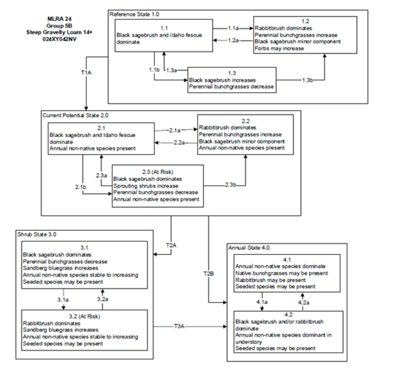
The Reference State is a representative of the natural range of variability under pristine conditions. The Reference State has three general community phases; a shrub-grass dominant phase, a shrub dominant phase and a grass dominate phase. State dynamics are maintained by interactions between climatic patterns and disturbance regimes. Negative feedbacks enhance ecosystem resilience and contribute to the stability of the state. These include the presence of all structural and functional groups, low fine fuel loads, and retention of organic matter and nutrients. Plant community phase changes are primarily driven by fire, periodic drought and/or insect or disease attack. Due to the nature and extent of disturbance in this site, all three plant community phases would likely occur in a mosaic across the landscape.
Community 1.1 Reference Plant Community
The reference plant community is dominated by black sagebrush, Idaho fescue, and Cusick's bluegrass.
Potential vegetative composition is about 60% grasses, 10% forbs and 30% shrubs.
Approximate ground cover (basal and crown) is 30 to 40 percent.
Figure 3. Annual production by plant type (representative values) or group (midpoint values)
Table 5. Annual production by plant type
Plant type
Low (lb/acre)
Representative value (lb/acre)
High (lb/acre)
Grass/Grasslike
300
480
600
Shrub/Vine
150
240
300
Forb
50
80
100
Total
500
800
1000
Community 1.2 Reference Plant Community 1.2
This community phase is characteristic of a post-disturbance, early seral community phase. Thurber’s needlegrass, Indian ricegrass and other perennial bunchgrasses dominate. Sprouting shrubs such as Douglas’ rabbitbrush, spiny hopsage, and shadscale may increase. Black sagebrush could still be present in unburned patches. Forbs may increase post-fire but will likely return to pre-burn levels within a few years. Sandberg bluegrass will generally increase following fire, but may decrease in below-average years of precipitation. Sandberg bluegrass may also increase.
Community 1.3 Reference Plant Community 1.3
Black sagebrush increases in the absence of disturbance. Decadent sagebrush dominates the overstory and the deep-rooted perennial bunchgrasses in the understory are reduced either from competition with shrubs and/or herbivory. Sandberg bluegrass may increase in the understory and become the dominant grass on the site.
Pathway 1.1a Community 1.1 to 1.2
Low severity fire resulting in a mosaic pattern.
Pathway 1.1b Community 1.1 to 1.3
Time and lack of disturbance such as fire. Drought, herbivory, or combinations of these would reduce the perennial grasses in the understory.
Pathway 1.2a Community 1.2 to 1.1
Time and lack of disturbance such as fire.
Pathway 1.3a Community 1.3 to 1.1
Low severity fire or herbivory resulting in a mosaic pattern.
Pathway 1.3b Community 1.3 to 1.2
High severity fire significantly reduces sagebrush cover leading to early/mid-seral community.
State 2 Current Potential State
This state is similar to the Reference State 1.0 and has three similar community phases. Ecological function has not changed in this state, but the resiliency of the state has been reduced by the presence of invasive weeds. These non-native species can be highly flammable, and promote fire where historically fire had been infrequent. Negative feedbacks enhance ecosystem resilience and contribute to the stability of the state. These include the presence of all structural and functional groups, low fine fuel loads and retention of organic matter and nutrients. Positive feedbacks decrease ecosystem resilience and stability of the state. These include the non-natives high seed output, persistent seed bank, rapid growth rate, ability to cross pollinate and adaptations for seed dispersal.
Community 2.1 Plant Community 2.1
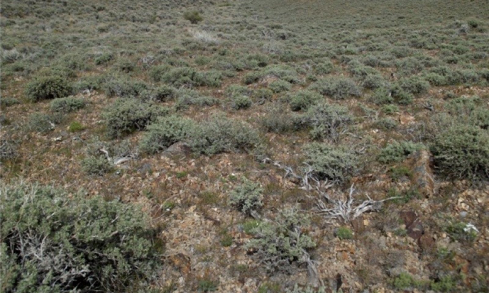
Figure 4. Steep Gravelly Loam 14 phase 2.1 T. Stringham June 2010
This community phase is compositionally similar to the Reference State Community Phase 1.1 with the presence of non-native species in trace amounts. This community is dominated by black sagebrush in the overstory with Thurber’s needlegrass, Indian ricegrass dominant in the understory.
Community 2.2 Plant Community 2.2
This community phase is characteristic of a post-disturbance, early seral community where annual non-native species are present. Sagebrush is present in trace amounts; perennial bunchgrasses dominate the site. Depending on fire severity patches of intact sagebrush may remain. Rabbitbrush or other sprouting shrubs may be increasing. Annual non-native species are stable or increasing within the community.
Sandberg bluegrass will generally increase following fire, but may decrease in below-average years of precipitation. Annual non-native species generally respond well after fire and may be stable or increasing within the community.
Community 2.3 Plant Community (At-Risk) 2.3
Black sagebrush dominates the overstory and perennial bunchgrasses in the understory are reduced, either from competition with shrubs or from inappropriate grazing, or from both. Rabbitbrush may be a significant component. Sandberg bluegrass may increase and become co-dominant with deep rooted bunchgrasses. Annual non-native species may be stable or increasing due to lack of competition with perennial bunchgrasses. This site is susceptible to further degradation from grazing, drought, and fire. This community is at risk of crossing a threshold to either Shrub State 3.0 (grazing or fire) or Annual State 4.0 (fire).
Pathway 2.1b Community 2.1 to 2.2
Time and lack of disturbance such as fire. Drought, inappropriate grazing management, or combinations of these would reduce the perennial grasses in the understory.
Pathway 2.1a Community 2.1 to 2.3
Fire or brush treatments (i.e. mowing) with minimal soil disturbance.
Pathway 2.2a Community 2.2 to 2.1
Time and lack of disturbance such as fire, drought, inappropriate grazing management, or combinations of these.
Pathway 2.3a Community 2.3 to 2.1
Low severity fire creates sagebrush/grass mosaic. Brush treatment with minimal soil disturbance and/or grazing management that reduces shrubs would allow for an increase in perennial bunchgrasses.
Pathway 2.3b Community 2.3 to 2.2
High severity fire significantly reduces sagebrush and leads to early/mid-seral community.
State 3 Shrub State
This state has two community phases, one that is characterized by a black sagebrush overstory and the other with a shadscale or rabbitbrush overstory with a Sandberg bluegrass understory. The site has crossed a biotic threshold and site processes are being controlled by shrubs. Bare ground has increased and pedestalling of grasses may be excessive.
Community 3.1 Plant Community 3.1
Black sagebrush dominates overstory while Sandberg bluegrass dominates the understory. Deep-rooted perennial bunchgrasses have significantly declined. Annual non-native species may be present. Bare ground and soil redistribution may be increasing. If present on the site, Utah juniper is increasing. The community phase may be at risk of transitioning into an Annual State.
Community 3.2 Plant Community (At-Risk) 3.2
Shadscale and/or rabbitbrush dominate the overstory. Broom snakeweed may be present to increasing. Annual non-native species may be increasing and bare ground is significant. This site is at risk for an increase in invasive annual weeds.
Pathway 3.1a Community 3.1 to 3.2
Fire and/or sheep grazing management which reduces black sagebrush. Brush treatments (i.e. mowing) with minimal soil disturbance.
Pathway 3.2a Community 3.2 to 3.1
Time and lack of disturbance and/or grazing management that favors the establishment and growth of sagebrush allows for the shrub component to recover.
State 4 Annual State
This state has two community phases; one dominated by annual non-native species and the other is a shrub dominated site. This state is characterized by the dominance of annual non-native species such as cheatgrass and tansy mustard in the understory. Sagebrush and/or rabbitbrush may dominate the overstory. Annual non-native species and squirreltail dominate the understory.
Community 4.1 Plant Community 4.1
Annual non-native plants such as cheatgrass or tansy mustard dominate the site. This phase may have seeded species present if resulting from a failed seeding attempt.
Community 4.2 Plant Community 4.2
Wyoming big sagebrush remains in the overstory with annual non-native species, likely cheatgrass, dominating the understory. Trace amounts of desirable bunchgrasses may be present.
Pathway 4.1a Community 4.1 to 4.2
Time and lack of disturbance (unlikely to occur).
Pathway 4.2a Community 4.2 to 4.1
Fire.
Transition T1A State 1 to 2
Introduction of non-native plants.
Transition T2A State 2 to 3
Time and lack of disturbance and/or inappropriate grazing management (to 3.1) or fire, soil disturbing brush treatments and/or inappropriate sheep grazing (3.2).
Transition T2B State 2 to 4
Fire in at-risk community phase (from 2.3) may transition to annual state (4.0), soil disturbing treatments may also transition to an annual state.
Livestock Interpretations:
This site has limited value for livestock grazing, due to steep slopes. Grazing management should be keyed to dominant grasses or palatable shrubs production. Idaho fescue provides important forage for many types of domestic livestock. The foliage cures well and is preferred by livestock in late fall and winter. Cusick's bluegrass makes up only a small proportion of the biomass of the sagebrush communities in which it lives, but it is often taken preferentially by cattle, especially early in the season. Bluebunch wheatgrass is considered one of the most important forage grass species on western rangelands for livestock. Although bluebunch wheatgrass can be a crucial source of forage, it is not necessarily the most highly preferred species. In winter, at lower elevations, black sagebrush is heavily utilized by domestic sheep.
Stocking rates vary over time depending upon season of use, climate variations, site, and previous and current management goals. A safe starting stocking rate is an estimated stocking rate that is fine tuned by the client by adaptive management through the year and from year to year.
Wildlife Interpretations:
Idaho fescue provides important forage for several wildlife species. It is reported to be good forage for pronghorn, and deer in ranges of northern Nevada. Deer, elk, and mountain goat also use Cusick's bluegrass early in the season. The value of Cusick's bluegrass as cover for small animals has been rated as poor to fair. Bluebunch wheatgrass is considered one of the most important forage grass species on western rangelands for wildlife. Bluebunch wheatgrass does not generally provide sufficient cover for ungulates, however, mule deer are frequently found in bluebunch-dominated grasslands. Black sagebrush is a significant browse species within the Intermountain region. It is especially important on low elevation winter ranges in the southern Great Basin, where extended snow free periods allow animal’s access to plants throughout most of the winter. In these areas it is heavily utilized by pronghorn and mule deer. Sagebrush-grassland communities provide critical sage-grouse breeding and nesting habitats. Sagebrush is a crucial component of their diet year-round, and sage-grouse select sagebrush almost exclusively for cover.
Hydrological functions
Runoff is medium to high. Permeability is moderate. Hydrologic soil groups are B and C. Rills are none. Rock fragments armor the surface. Water flow patterns are none to rare. Rock fragments armor the surface. Pedestals are none to rare. Occurrence is usually limited to areas of water flow patterns. Frost heaving of shallow rooted plants should not be considered an indicator of soil erosion. Gullies are none. Perennial herbaceous plants (especially deep-rooted bunchgrasses [i.e., Idaho fescue]) slow runoff and increase infiltration. Shrub canopy and associated litter break raindrop impact and provide opportunity for snow catch and accumulation on site.
Recreational uses
Aesthetic value is derived from the diverse floral and faunal composition and the colorful flowering of wild flowers and shrubs during the spring and early summer. This site offers rewarding opportunities to photographers and for nature study. This site is used for hiking and has potential for upland and big game hunting.
Other information
Black sagebrush is an excellent species to establish on sites where management objectives include restoration or improvement of domestic sheep, pronghorn, or mule deer winter range.
Supporting information
Inventory data references
NASIS soil component data.
Type locality
Location 1: Humboldt County, NV
Township/Range/Section
T32N R43E S2
UTM zone
N
UTM northing
4502894
UTM easting
491538
Latitude
40° 40′ 36″
Longitude
117° 6′ 0″
General legal description
NW¼SW¼ West slope off North Peak on Battle Mountain, Elder Creek area, Humboldt County, Nevada. This site also occurs in Elko, Eureka, Lander, and Pershing Counties, Nevada.
Interpreting Indicators of Rangeland Health is a qualitative assessment protocol used to
determine ecosystem condition based on benchmark characteristics described in the Reference Sheet. A suite of 17 (or
more) indicators are typically considered in an assessment. The ecological site(s) representative of an assessment
location must be known prior to applying the protocol and must be verified based on soils and climate. Current plant
community cannot be used to identify the ecological site.
Author(s)/participant(s)
Patti Novak-Echenique
Contact for lead author
State Rangeland Management Specialist
Date
03/19/2010
Approved by
Kendra Moseley
Approval date
Composition (Indicators 10 and 12) based on
Annual Production
Indicators
Number and extent of rills:
Rills are none. Rock fragments armor the surface.
Presence of water flow patterns:
Water flow patterns are none to rare. Rock fragments armor the surface.
Number and height of erosional pedestals or terracettes:
Pedestals are none to rare. Occurrence is usually limited to areas of water flow patterns. Frost heaving of shallow rooted plants should not be considered an indicator of soil erosion.
Bare ground from Ecological Site Description or other studies (rock, litter, lichen, moss, plant canopy are
not bare ground):
Bare Ground 10-20%.
Number of gullies and erosion associated with gullies:
Gullies are none.
Extent of wind scoured, blowouts and/or depositional areas:
None
Amount of litter movement (describe size and distance expected to travel):
Fine litter (foliage from grasses and annual & perennial forbs) expected to move distance of slope length during intense summer convection storms or rapid snowmelt events. Persistent litter (large woody material) will remain in place except during catastrophic events.
Soil surface (top few mm) resistance to erosion (stability values are averages - most sites will show a range
of values):
Soil stability values should be 3 to 6 on most soil textures found on this site. (To be field tested.)
Soil surface structure and SOM content (include type of structure and A-horizon color and thickness):
Surface structure is typically thin platy or granular. Soil surface colors are dark and soils have a mollic epipedon. Organic matter of the surface 2 to 4 inches is typically 1 to 3 percent dropping off quickly below. Organic matter content can be more or less depending on micro-topography.
Effect of community phase composition (relative proportion of different functional groups) and spatial
distribution on infiltration and runoff:
Perennial herbaceous plants (especially deep-rooted bunchgrasses [i.e., Idaho fescue]) slow runoff and increase infiltration. Shrub canopy and associated litter break raindrop impact and provide opportunity for snow catch and accumulation on site.
Presence and thickness of compaction layer (usually none; describe soil profile features which may be
mistaken for compaction on this site):
Compacted layers are not typical. Subangular blocky, platy, or massive sub-surface horizons are not to be interpreted as compacted.
Functional/Structural Groups (list in order of descending dominance by above-ground annual-production or live foliar
cover using symbols: >>, >, = to indicate much greater than, greater than, and equal to):
Amount of plant mortality and decadence (include which functional groups are expected to show mortality or
decadence):
Dead branches within individual shrubs common and standing dead shrub canopy material may be as much as 20% of total woody canopy; some of the mature bunchgrasses (<10%) have dead centers.
Average percent litter cover (%) and depth ( in):
Between plant interspaces (± 25%) and litter depth is ±¼ inch.
Expected annual annual-production (this is TOTAL above-ground annual-production, not just forage annual-production):
For normal or average growing season (through mid-June) ± 800 lbs/ac; Spring moisture significantly affects total production.
Potential invasive (including noxious) species (native and non-native). List species which BOTH characterize
degraded states and have the potential to become a dominant or co-dominant species on the ecological site if
their future establishment and growth is not actively controlled by management interventions. Species that become
dominant for only one to several years (e.g., short-term response to drought or wildfire) are not invasive
plants. Note that unlike other indicators, we are describing what is NOT expected in the reference state for the
ecological site:
Increasers include Douglas’ rabbitbrush. Invaders include halogeton and cheatgrass.
Perennial plant reproductive capability:
All functional groups should reproduce in average (or normal) and above average growing season years.
The Ecosystem Dynamics Interpretive Tool is an information system framework developed by the USDA-ARS Jornada Experimental Range, USDA Natural Resources Conservation Service, and New Mexico State University.
Click on box and path labels to scroll to the respective text.