
Natural Resources
Conservation Service
Ecological site R042AD001NM
Loamy, Dry Mixed Prairie
Accessed: 04/24/2025
General information
Provisional. A provisional ecological site description has undergone quality control and quality assurance review. It contains a working state and transition model and enough information to identify the ecological site.
Figure 1. Mapped extent
Areas shown in blue indicate the maximum mapped extent of this ecological site. Other ecological sites likely occur within the highlighted areas. It is also possible for this ecological site to occur outside of highlighted areas if detailed soil survey has not been completed or recently updated.
Table 1. Dominant plant species
| Tree |
Not specified |
|---|---|
| Shrub |
Not specified |
| Herbaceous |
Not specified |
Physiographic features
This site consists of very deep, soils that formed in calcareous alluvium derived from sedimentary materal. The sites are on alluvial bottoms, fan aprons and, inset fans, fan piedmonts, terraces and have slopes of 0 to 5 percent. The mean annual precipitation is about 12 inches and the mean annual air temperature is about 61 degrees F.
Elevations range from 4700 to 6000 feet above sea level.
Table 2. Representative physiographic features
| Landforms |
(1)
Fan apron
(2) Inset fan (3) Fan piedmont |
|---|---|
| Flooding duration | Very brief (4 to 48 hours) |
| Flooding frequency | Rare |
| Ponding frequency | None |
| Elevation | 1,433 – 1,829 m |
| Slope | 0 – 5% |
| Water table depth | 152 cm |
| Aspect | Aspect is not a significant factor |
Climatic features
Average precipitation for this site is approximately 12 to 14 inches. Variations of 5 inches are not uncommon. Approximately 75 percent occurs from May through October with most of the rainfall occurring from July to September. Most of the summer precipitation comes in the form of high intensity, short duration thunderstorms. Rain and snow of low intensity characterize the limited winter precipitation.
Temperatures are mild. Freezing temperatures are common at night from December through April, however, temperatures during the day are frequently above 50 degrees F. Occasionally in December to February brief periods of 0 degrees F. temperatures may be expected. During June to August some days may exceed 100 degrees F.
The mean annual precipitation figures are derived from rain gauge data collected by the BLM (1971 to 1990), and NOAA weather maps utilizing prism model estimation techniques. There are no permanent weather stations within the boundaries of the Land Resource Unit.
Table 3. Representative climatic features
| Frost-free period (average) | 180 days |
|---|---|
| Freeze-free period (average) | 185 days |
| Precipitation total (average) | 356 mm |
Figure 2. Monthly precipitation range
Figure 3. Monthly average minimum and maximum temperature
Influencing water features
This site is not influenced by water from wetland or stream.
Soil features
Soils are deep to very deep. Surface layers are loam, and silt loam. Substratum textures are loam, silt loam, clay loam and silty clay loam. Subsoil textures are loam, silt loam and silty clay loam. Some subsoils may have more than 15 percent calcium carbonate. The soils are well drained and have a moderately slow permeability. Available water capacity is very high. This site usually receives some extra water from higher surrounding terrain. If unprotected by vegetative cover the soils become susceptible to water erosion.
Minimum and maximum values listed below represent the characteristic soils for this site.
Characteristic soils:
Reyab
Salado
Table 4. Representative soil features
| Parent material |
(1)
Alluvium
–
limestone
|
|---|---|
| Surface texture |
(1) Loam (2) Silt loam (3) Silty clay loam |
| Family particle size |
(1) Loamy |
| Drainage class | Moderately well drained to well drained |
| Permeability class | Moderately slow to moderate |
| Soil depth | 152 – 203 cm |
| Surface fragment cover <=3" | 0 – 5% |
| Surface fragment cover >3" | 0% |
| Available water capacity (0-101.6cm) |
14.73 – 17.27 cm |
| Calcium carbonate equivalent (0-101.6cm) |
0 – 15% |
| Electrical conductivity (0-101.6cm) |
0 – 4 mmhos/cm |
| Sodium adsorption ratio (0-101.6cm) |
0 |
| Soil reaction (1:1 water) (0-101.6cm) |
7.4 – 8.4 |
| Subsurface fragment volume <=3" (Depth not specified) |
0 – 5% |
| Subsurface fragment volume >3" (Depth not specified) |
0% |
Ecological dynamics
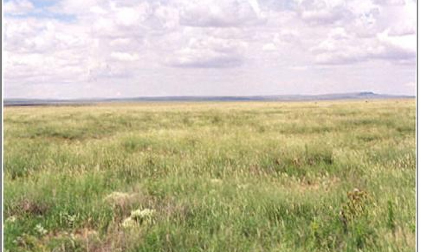
The aspect of this site’s historic plant community is open prairie grassland. This site is positioned in a topographic setting to receive run-on water from adjacent gravelly and shallow sandy sites. Short grasses dominate with varying amounts of mid to tall grasses occupying the moister microclimates within the site. Blue grama and tobosa are the dominant grass species. Occasional forbs and woody shrubs occur in association with the grasses. Broad collections of soil series are often grouped into the loamy site and the differences in these series can often account for variations in the plant communities. Grass species dominance fluctuates between blue grama and tobosa, and can be affected by soil texture, landscape position, and disturbance. Retrogression within the grassland state is characterized by a decrease of blue grama, and an increase in tobosa, burrograss and tarbush.
Transition to a shrub-invaded state is facilitated by loss of grass cover due to drought or overgrazing. Fire suppression and increased winter precipitation may also be important components favoring shrub seedling establishment. Continued reduction in grass cover and increased erosion may eventually lead to a shrub-dominated state. Once erosion has removed soil surface horizons, shrub removal will not result in grass recovery. Few systematic studies of vegetation dynamics have been preformed within the SD-4 Loamy ecological site. Generally this site is less susceptible to shrub encroachment than those sites receiving less run-on water.
State and transition model
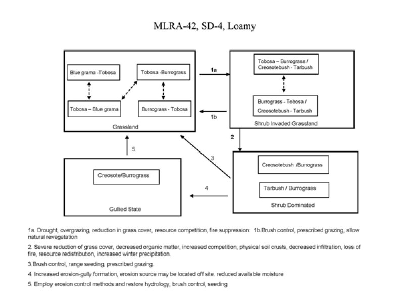
Figure 4. Loamy S&T Diagram
More interactive model formats are also available.
View Interactive Models
More interactive model formats are also available.
View Interactive Models
Click on state and transition labels to scroll to the respective text
State 1 submodel, plant communities
State 2 submodel, plant communities
State 3 submodel, plant communities
State 4 submodel, plant communities
State 1
HCPC
Community 1.1
Grassland Community

Figure 5. Grassland
Blue grama and tobosa are the dominant grass species of the historic plant community. Additional species such as cane bluestem, sideoats grama, green sprangletop, plains lovegrass, alkali sacaton, and vine mesquite inhabit areas within the site that are situated to receive extra run-on water. Important forbs include croton, bladderpod and globemallow. Woody species such as winterfat, soaptree yucca, ephedra, tarbush, cholla and prickly pear appear in limited amounts sparsely scattered across the site. Tobosa usually dominates on the silt loam Reyab soil series that occur in lower landscape positions, whereas blue grama dominates on the higher and drier Salado series (Fort Bliss Soil Survey). Tobosa seems to be better adapted to those soils that have relatively long periods of soil moisture availability. Blue grama is drought resistant and makes use of limited available water on the Salado soils. Salado series also have a calcic horizon at about 20 inches. Species diversity decreases with heavy grazing pressure and/or drought. As retrogression occurs, secondary species such as green sprangletop, plains lovegrass, sideoats grama and Arizona cottontop are the first to decline, these are followed by a decrease in vine mesquite, alkali sacaton, cane bluestem, blue grama, and winterfat. As a result of declines in these competitors, tobosa may increase, at least initially. Tobosa decreases and is eventually replaced by burrograss as the site continues to degrade. This increase in burrograss may indicate that the site is vulnerable to encroachment by shrubs and soil degradation. Diagnosis: Grass cover is fairly uniform with few large (< 1 m) gaps. Tobosa and blue grama are dominant grasses. Shrubs such as soaptree yucca, ephedra, winterfat, tarbush, prickly pear and cholla are sparsely scattered or absent. Creosotebush is not present. Evidence of erosion including rills, pedestaling and litter movement is minimal.
Figure 6. Annual production by plant type (representative values) or group (midpoint values)
Table 5. Annual production by plant type
| Plant type | Low (kg/hectare) |
Representative value (kg/hectare) |
High (kg/hectare) |
|---|---|---|---|
| Grass/Grasslike | 813 | 1278 | 1704 |
| Forb | 67 | 54 | 83 |
| Shrub/Vine | 17 | 13 | 7 |
| Total | 897 | 1345 | 1794 |
Figure 7. Plant community growth curve (percent production by month). NM5801, R042XD001NM Loamy HCPC. R042XD001NM Loamy HCPC Average rainfall year.
| Jan | Feb | Mar | Apr | May | Jun | Jul | Aug | Sep | Oct | Nov | Dec |
|---|---|---|---|---|---|---|---|---|---|---|---|
| J | F | M | A | M | J | J | A | S | O | N | D |
| 0 | 0 | 3 | 3 | 8 | 7 | 18 | 28 | 25 | 6 | 2 | 0 |
State 2
Shrub Invaded Grassland State
This state is characterized by the invasion of creosotebush and/or an increase in tarbush. Tobosa and burrograss are the dominant grass species of this state. Retrogression within this state results in a reduction of grass cover and an increase in creosotebush or tarbush. As grass cover is reduced organic matter is reduced and infiltration and soil aggregate stability decline.4 This results in increased erosion rates and lower available soil moisture. Grazing management needs to be implemented to maintain or increase adequate grass cover to protect soil resources and impede shrub seedling establishment. The presence of creosotebush on adjacent gravelly sites may increase the probability of creosotebush encroachment on the loamy site. Those loamy soils with calcareous horizons or even small amounts of gravel in the profile, such as in Salado soil series, seem to be at greater risk of invasion by creosotebush. Diagnosis: Tobosa and burrograss cover is variable and can range from fairly uniform to patchy. Creosotebush is present and/or there is an increased representation of tarbush. Creosotebush-tarbush canopy cover may eventually approach co-dominance with grasses.
Community 2.1
Shrub Invaded Community
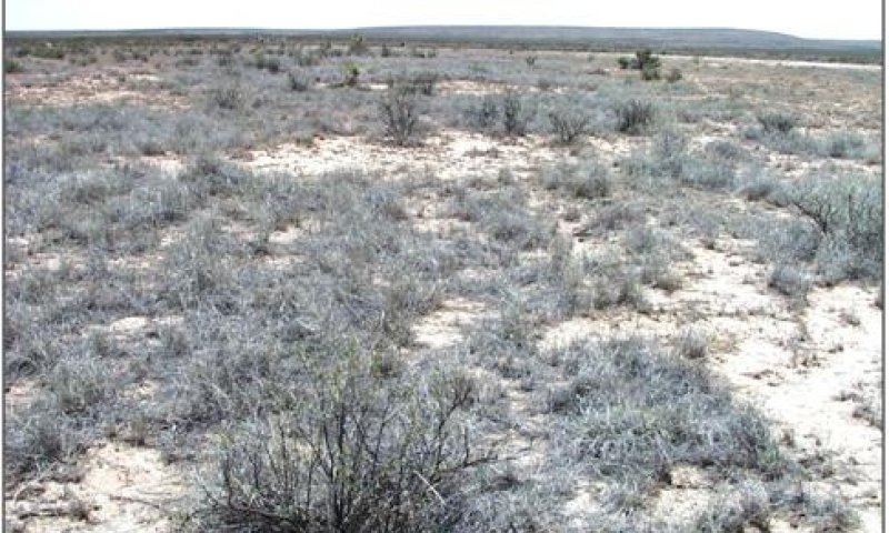
Figure 8. Shrub Invaded
This community supports woody plant composition of creosote bush, tarbush, ephedra, prickly pear species, and cholla. Winterfat will most likely decrease in this community because of increased grazing. There will be a continued decline in diversity of the grassland component and an increase in woody species. Annual herbage production is reduced due to a decline in soil fertility, structure, and organic matter. Plant composition will have shifted strongly toward the non herbaceous component.
State 3
Shurb Dominated State
Shrubs dominate this state in both composition and aspect. Grass cover is limited and large interconnected bare patches occupy areas between shrubs. Burrograss is the dominant grass, threeawns increase and clumps of tobosa are scattered across the site occupying the more protected areas or positions receiving a little more moisture. Increased shrub density and decreased grass cover characterize retrogression within this state. Reduction of grass cover and increased physical soil crusts reduce infiltration and available soil moisture. Slope, amount and timing of overland flow the site receives, soil aggregate stability, and amount of physical and biological crusts influence soil erosion rates on this site. Diagnosis: Creosotebush, tarbush or a mix of both are present and dominate the site. Grass cover is sparse with frequent interconnected large bare patches (>1m). Physical soil crusts are present reducing infiltration and available soil moisture. Evidence of erosion including rills, pedestals and litter movement can be common. Gullies may be present.
Community 3.1
Shrub Dominated Community
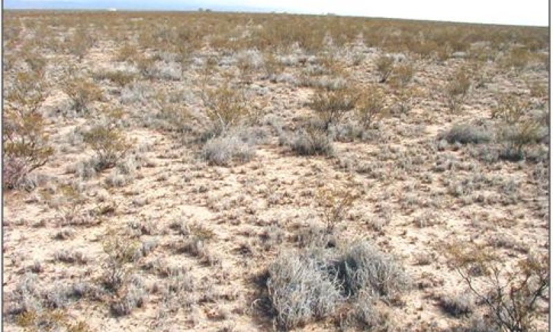
Figure 9. Shrub Dominated
This community supports woody plant composition of creosote bush, tarbush, ephedra, prickly pear species, and cholla. Winterfat will most likely not be in this community because of grazing. The grassland component of this community will be almost non-existent and woody species will dominate this site. Annual herbage production is reduced due to a decline in soil fertility, structure, and organic matter. Plant composition will have shifted strongly toward the non herbaceous component. Because of lowered fertility and competition for nutrients and water from the woody plants the grassland component shows general lack of plant vigor and productivity.
State 4
Gullied State
This state is characterized by erosion and a change in hydrology. Loamy sites receive run-on water from higher adjacent sites. A change in natural flow patterns can cause a concentration of overland flow, accelerated erosion, and subsequent gully formation. Burrograss is the dominant grass species. Threeawns and fluffgrass are also present. Creosotebush or tarbush is the dominant shrub.
Community 4.1
Gullied Shrub/Burrograss Community
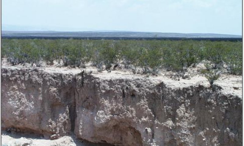
Figure 10. Gullied
Creosote bush/Tarbush and burrograss dominate this site. Because of decrease in herbaceous cover and large interspaces between woody species this site doesn’t allow for proper infiltration of precipitation or run-on from adjacent sites thus allowing the soil to erode and cut. These cuts further the drying process on this site thus hindering the this site from healing itself without major management.
Transition 1a
State 1 to 2
Periods of severe drought can reduce grass production, cover, and composition regardless of whether or not the site is being grazed2. Reduction in production and grass cover due to drought or overgrazing results in an increase in the amount and size of bare patches. These patches may provide competition-free sites and facilitate shrub seedling establishment. Years of above average precipitation during winter month may favor shrub establishment by making soil moisture available to shrubs during periods of C4 grass dormancy.1 If fire historically played a part in Chihuahuan Desert grasslands ecology then fire suppression may aid shrub establishment.3 Key indicators of approach to transition: Loss of vine mesquite, an indicator of decreasing species diversity. Loss of blue grama cover. Increase in burrograss cover. Increases in bare patch size. Appearance of creosotebush or tarbush seedlings.
Restoration pathway 1b
State 2 to 1
Brush management may be necessary to remove competition from shrubs and restore cover. Allow natural revegetation of grasses to occur following brush control. Control of forage utilization through prescribed grazing will help to ensure recovery and increase cover.
Transition 2
State 2 to 3
Continued overgrazing and/or drought further reduce grass production and cover, favoring shrub expansion by decreasing organic matter, and reducing competition for resources between grasses and shrub seedlings. The formation of soil surface physical crusts decreases infiltration and impedes grass seedling establishment. Lack of adequate grass cover also eliminates the opportunity for natural or prescribed fires to suppress shrubs. Once shrubs are established, the redistribution of water and nutrient resources around shrubs favors further shrub growth and recruitment. Periods of above-average precipitation during winter months may also favor shrub establishment and growth.1 Key indicators of approach to transition: Increase in amount of creosotebush or tarbush seedlings and young plants. Increases in the number of bare patches and decreases in overall grass cover. Increases in bare patch size Soil surface physical crusting Increased evidence of erosion such as rills, small gullies or pedestaling of plants.
Restoration pathway 3
State 3 to 1
Brush management is necessary to remove competition from shrubs. Range seeding is needed to supply adequate seed source. Pitting and seeding prior to summer rains may help break up soil physical crusts, create small pits to hold water and increase survival of grass seedlings. Soil physical crusts, loss of organic matter, and degree of erosion affect the probability of successful grass establishment.
Transition 4
State 3 to 4
Loss of adequate grass cover necessary to protect soil from run-on water from higher adjacent sites can facilitate this transition. Reduced cover, organic matter, and soil aggregate stability increase susceptibility to erosion and subsequent gully formation. This transition can be caused by both offsite (concentration of overland flow) and onsite (decreased soil stability) factors. Key indicators of approach to transition: Rills or small gullies along roads or trails running parallel with slope on adjacent upland sites. Increased evidence of physical soil crusts and water flow patterns. Increased evidence of erosion such as rills, small gullies.
Restoration pathway 5
State 4 to 1
Erosion control practices are essential to restore hydrology. Brush management is needed to remove competition from shrubs and allow grass seedling establishment. Range seeding is required to supply adequate seed source for blue grama, tobosa, and other grasses originally present in grassland state. Grazing management is necessary to defer grazing until plants are established following seeding and insure proper forage utilization once grazing is resumed. Management practices required to drive the transition back to grassland are costly and chances for successful grass establishment are dependent on adequate precipitation following seeding and degree of soil degradation.
Additional community tables
Table 6. Community 1.1 plant community composition
| Group | Common name | Symbol | Scientific name | Annual production (kg/hectare) | Foliar cover (%) | |
|---|---|---|---|---|---|---|
|
Grass/Grasslike
|
||||||
| 1 | 336–404 | |||||
| tobosagrass | PLMU3 | Pleuraphis mutica | 336–404 | – | ||
| 2 | 336–404 | |||||
| blue grama | BOGR2 | Bouteloua gracilis | 336–404 | – | ||
| 3 | 135–161 | |||||
| vine mesquite | PAOB | Panicum obtusum | 84–112 | – | ||
| cane bluestem | BOBA3 | Bothriochloa barbinodis | 56–84 | – | ||
| sideoats grama | BOCU | Bouteloua curtipendula | 56–84 | – | ||
| Hall's panicgrass | PAHA | Panicum hallii | 28–56 | – | ||
| 4 | 108–135 | |||||
| sand muhly | MUAR2 | Muhlenbergia arenicola | 84–112 | – | ||
| alkali sacaton | SPAI | Sporobolus airoides | 84–112 | – | ||
| sand dropseed | SPCR | Sporobolus cryptandrus | 28–56 | – | ||
| 5 | 67–108 | |||||
| Arizona cottontop | DICA8 | Digitaria californica | 34–50 | – | ||
| plains lovegrass | ERIN | Eragrostis intermedia | 34–50 | – | ||
| green sprangletop | LEDU | Leptochloa dubia | 34–50 | – | ||
| 6 | 40–67 | |||||
| threeawn | ARIST | Aristida | 40–67 | – | ||
| ear muhly | MUAR | Muhlenbergia arenacea | 40–67 | – | ||
| burrograss | SCBR2 | Scleropogon brevifolius | 40–67 | – | ||
|
Forb
|
||||||
| 7 | 13–27 | |||||
| croton | CROTO | Croton | 13–27 | – | ||
| bladderpod | LESQU | Lesquerella | 13–27 | – | ||
| globemallow | SPHAE | Sphaeralcea | 13–27 | – | ||
| 8 | 7–13 | |||||
| Forb, perennial | 2FP | Forb, perennial | 7–13 | – | ||
| 9 | 7–13 | |||||
| Forb, annual | 2FA | Forb, annual | 7–13 | – | ||
|
Shrub/Vine
|
||||||
| 10 | 3–7 | |||||
| jointfir | EPHED | Ephedra | 3–7 | – | ||
| American tarwort | FLCE | Flourensia cernua | 3–7 | – | ||
| winterfat | KRLA2 | Krascheninnikovia lanata | 3–7 | – | ||
| 11 | 3–7 | |||||
| pricklypear | OPUNT | Opuntia | 3–7 | – | ||
| soaptree yucca | YUEL | Yucca elata | 3–7 | – | ||
Interpretations
Animal community
Wildlife:This site provides habitat which supports a resident wildlife community characterized by pronghorn antelope, coyote, badger, black-tailed prairie dog, red-tailed hawk, meadow lark, horned lark and prairie rattlesnake.
Hydrological functions
This site normally receives approximately 12-14 inches annual precipitation. Most summer rainfall occurs as brief sometimes-heavy thunderstorms. Soils are deep to very deep and rated as being in hydrologic group B. Slopes range from 0 - 5 percent. Permeability is moderately slow.
Runoff is low to medium, and the hazard of water erosion is slight to moderate. Available water capacity to a depth of 40 inches is moderate. As basal cover and litter are reduced and the size of gaps between vegetation increases, the surface soils become exposed to accelerated erosion.
Soil Hydrologic Unit
Reyab ----------B
Saldado --------B
Recreational uses
This site offers good potential for antelope and predator hunting, wildlife observation and photography. Scenic beauty of this site will especially appeal to those who value wide open prairie grasslands.
Wood products
This site has no significant value for wood products.
Other products
Grazing: Currently the majority of the livestock use on this site is with mother cows in cow-calf operations. Historic use has been sheep and cattle. The plant community on this site is well suited to grazing by both domestic livestock of all kinds and by wildlife at all seasons of the year.
This site responds best to a system of management that rotates the season of use. Initial starting stocking rates will be determined with the landowner or decision-maker. They will be based on past use histories and type and condition of the vegetation. Calculations used to determine an initial starting stocking rate will also be based on forage preference ratings.
Supporting information
Inventory data references
Supporting information includes limited clipping data, soil survey investigations, aerial photographs, and personal observations.
Type locality
| Location 1: Otero County, NM | |
|---|---|
| Township/Range/Section | T24S R13E S15 |
| General legal description | Otero County, New Mexico; on Otero Mesa about 1.8 miles south on County Road 506 from the guard station on the east gate of the McGregor Missile Range and 250 feet west of the road; NW1/4, NW1/4 section 15, T.24S., R.13E. |
Other references
1. Moir, W. H., and J. A. Ludwig. 1991. Plant succession and changing land features in desert grasslands. P. 15-18. In P.F. Ffolliott and W.T. Swank (eds.) People and the temperate region: a summary of research from the United States Man and the Biosphere Program 1991. U.S. Dept. State, Publ No. 9839, Nat. Tech. Info. Serv., U.S. Dept. Commerce, Springfield, Illinois. 63 p.
2. Holechek, J.L., R.D. Pieper, and C.H. Herbel. 1989. Range Management Principles and Practices. Prentice-Hall, Inc. Englewood Cliffs, New Jersey.
3. Brooks, M.L., and D.A. Pyke. 2001. Invasive plants and fire in the deserts of North America. Pages 1–14 in K.E.M. Galley and T.P. Wilson (eds.). Proceedings of the Invasive Species Workshop: the Role of Fire in the Control and Spread of Invasive Species.
Fire Conference 2000: the First National Congress on Fire Ecology, Prevention, and Management. Miscellaneous Publication No. 11,
Tall Timbers Research Station, Tallahassee, FL.
4. U.S. Department of Agriculture, Natural Resources Conservation Service. 2001. Soil Quality Information Sheets. Rangeland Soil Quality—Organic matter, infiltration, soil aggregate stability. Rangeland Sheets 6,5,3, [ONLINE] Available: http://www.statlab.iastate.edu/survey/SQI/range.html
Contributors
David Trujillo
Jason S. Martin
Rangeland health reference sheet
Interpreting Indicators of Rangeland Health is a qualitative assessment protocol used to determine ecosystem condition based on benchmark characteristics described in the Reference Sheet. A suite of 17 (or more) indicators are typically considered in an assessment. The ecological site(s) representative of an assessment location must be known prior to applying the protocol and must be verified based on soils and climate. Current plant community cannot be used to identify the ecological site.
| Author(s)/participant(s) | |
|---|---|
| Contact for lead author | |
| Date | |
| Approved by | |
| Approval date | |
| Composition (Indicators 10 and 12) based on | Annual Production |
Indicators
-
Number and extent of rills:
-
Presence of water flow patterns:
-
Number and height of erosional pedestals or terracettes:
-
Bare ground from Ecological Site Description or other studies (rock, litter, lichen, moss, plant canopy are not bare ground):
-
Number of gullies and erosion associated with gullies:
-
Extent of wind scoured, blowouts and/or depositional areas:
-
Amount of litter movement (describe size and distance expected to travel):
-
Soil surface (top few mm) resistance to erosion (stability values are averages - most sites will show a range of values):
-
Soil surface structure and SOM content (include type of structure and A-horizon color and thickness):
-
Effect of community phase composition (relative proportion of different functional groups) and spatial distribution on infiltration and runoff:
-
Presence and thickness of compaction layer (usually none; describe soil profile features which may be mistaken for compaction on this site):
-
Functional/Structural Groups (list in order of descending dominance by above-ground annual-production or live foliar cover using symbols: >>, >, = to indicate much greater than, greater than, and equal to):
Dominant:
Sub-dominant:
Other:
Additional:
-
Amount of plant mortality and decadence (include which functional groups are expected to show mortality or decadence):
-
Average percent litter cover (%) and depth ( in):
-
Expected annual annual-production (this is TOTAL above-ground annual-production, not just forage annual-production):
-
Potential invasive (including noxious) species (native and non-native). List species which BOTH characterize degraded states and have the potential to become a dominant or co-dominant species on the ecological site if their future establishment and growth is not actively controlled by management interventions. Species that become dominant for only one to several years (e.g., short-term response to drought or wildfire) are not invasive plants. Note that unlike other indicators, we are describing what is NOT expected in the reference state for the ecological site:
-
Perennial plant reproductive capability:
Print Options
Sections
Font
Other
The Ecosystem Dynamics Interpretive Tool is an information system framework developed by the USDA-ARS Jornada Experimental Range, USDA Natural Resources Conservation Service, and New Mexico State University.
Click on box and path labels to scroll to the respective text.