Natural Resources
Conservation Service
Ecological site F047XA512UT
High Mountain Loam (Douglas-fir)
Last updated: 2/05/2025
Accessed: 04/26/2025
General information
Provisional. A provisional ecological site description has undergone quality control and quality assurance review. It contains a working state and transition model and enough information to identify the ecological site.
MLRA notes
Major Land Resource Area (MLRA): 047X–Wasatch and Uinta Mountains
MLRA 47 occurs in Utah (86 percent), Wyoming (8 percent), Colorado (4 percent), and Idaho (2 percent). It encompasses approximately 23,825 square miles (61,740 square kilometers). The northern half of this area is in the Middle Rocky Mountains Province of the Rocky Mountain System. The southern half is in the High Plateaus of the Utah Section of the Colorado Plateaus Province of the Intermontane Plateaus. Parts of the western edge of this MLRA are in the Great Basin Section of the Basin and Range Province of the Intermontane Plateaus. The MLRA includes the Wasatch Mountains, which trend north and south, and the Uinta Mountains, which trend east and west. The steeply sloping, precipitous Wasatch Mountains have narrow crests and deep valleys. Active faulting and erosion are a dominant force in controlling the geomorphology of the area. The Uinta Mountains have a broad, gently arching, elongated shape. Structurally, they consist of a broadly folded anticline that has an erosion-resistant quartzite core. The Wasatch and Uinta Mountains have an elevation of 4,900 to about 13,500 feet (1,495 to 4,115 meters).
The mountains in this area are primarily fault blocks that have been tilted up. Alluvial fans at the base of the mountains are recharge zones for the basin fill aquifers. An ancient shoreline of historic Bonneville Lake is evident on the foot slopes along the western edge of the area. Rocks exposed in the mountains are mostly Mesozoic and Paleozoic sediments, but Precambrian rocks are exposed in the Uinta Mountains. The Uinta Mountains are one of the few ranges in the United States that are oriented west to east. The southern Wasatch Mountains consist of Tertiary volcanic rocks occurring as extrusive lava and intrusive crystalline rocks.
The average precipitation is from 8 to 16 inches (203 to 406 mm) in the valleys and can range up to 73 inches (1854 mm) in the mountains. In the northern and western portions of the MLRA, peak precipitation occurs in the winter months. The southern and eastern portions have a greater incidence of high-intensity summer thunderstorms; hence, a significant amount of precipitation occurs during the summer months. The average annual temperature is 30 to 50 degrees F (-1 to 15 C). The freeze-free period averages 140 days and ranges from 60 to 220 days, generally decreasing in length with increasing elevation.
The dominant soil orders in this MLRA are Aridisols, Entisols, Inceptisols, and Mollisols. The lower elevations are dominated by a frigid temperature regime, while the higher elevations experience cryic temperature regimes. Mesic temperature regimes come in on the lower elevations and south facing slopes in the southern portion of this MLRA. The soil moisture regime is typically xeric in the northern part of the MLRA, but grades to ustic in the extreme eastern and southern parts. The minerology is generally mixed and the soils are very shallow to very deep, generally-well drained, and loamy or loamy–skeletal.
Ecological site concept
The soils of this site are typically moderately deep and well-drained. They formed in colluvium and residium derived mainly from limestone, sandstone, shale, and quartzite. This site is correlated to both rocky and non-rocky soils, therefore rock fragments may occur on the soil surface and throughout the soil profile in some cases. pH is slightly acidic to mildly alkaline and available water-holding capacity ranges from 3.4 to 5.6 inches of water in the upper 40 inches of soil. The soil moisture regime for this site have been mapped as udic and the soil temperature regime is cryic.
Associated sites
| F047XA508UT |
High Mountain Loam (quaking aspen) |
|---|---|
| R047XA516UT |
High Mountain Loam (mountain big sagebrush) |
| R047XA560UT |
High Mountain Gravelly Loam (mountain big sagebrush) |
Similar sites
| F047XA532UT |
High Mountain Stony Loam (Douglas-fir) |
|---|---|
| R047XA526UT |
High Mountain Shallow Loam (Douglas-fir) |
Table 1. Dominant plant species
| Tree |
(1) Pseudotsuga menziesii |
|---|---|
| Shrub |
(1) Juniperus communis |
| Herbaceous |
(1) Carex rossii |
Physiographic features
The High Mountain Loam (Douglas Fir) ecological site typically occurs on sloping to very steep mountain slopes and mountains. Slopes normally range from 10 to 60 percent but may occasionally be steeper. Slope, aspect and elevation will influence the vegetative floristics of this site. Elevation ranges between 6,200 to 9,400 feet. Runoff is medium to high.
Table 2. Representative physiographic features
| Landforms |
(1)
Mountain slope
(2) Mountain |
|---|---|
| Runoff class | Medium to high |
| Flooding frequency | None |
| Ponding frequency | None |
| Elevation | 1,890 – 2,865 m |
| Slope | 10 – 60% |
| Aspect | Aspect is not a significant factor |
Climatic features
The climate is characterized by cold, snowy winters and cool summers. The average annual precipitation ranges from 24 to 34 inches. October thru April, are typically the wettest months with June thru August being the driest. The most reliable sources of moisture for plant growth are the snow that accumulates over the winter and spring rains. Summer thunderstorms are intermittent and sporadic in nature, and thus, are less reliable sources of moisture to support vegetative growth on this site. The typical mean annual air temperature ranges from 31 to 45 degrees Fahrenheit.
Table 3. Representative climatic features
| Frost-free period (characteristic range) | 55-79 days |
|---|---|
| Freeze-free period (characteristic range) | |
| Precipitation total (characteristic range) | |
| Frost-free period (average) | 70 days |
| Freeze-free period (average) | 110 days |
| Precipitation total (average) | 762 mm |
Figure 1. Monthly precipitation range
Figure 2. Monthly average minimum and maximum temperature
Influencing water features
There are no influencing water features on this site.
Wetland description
N/A
Soil features
The soils are typically moderately deep and well-drained. They formed in colluvium and residuum derived mainly from limestone, sandstone, and shale. This site is correlated to both rocky and non-rocky soils, therefore rock fragments may occur on the soil surface and throughout the soil profile in some cases. pH is slightly acidic to mildly alkaline and available water-holding capacity ranges from 3.4 to 5.6 inches of water in the upper 40 inches of soil. The soil moisture regime for this site have been mapped as udic and the soil temperature regimes is cryic.
The following soil series have been correlated to this ecological site:
Soil Survey Area:
Cache Valley Area (UT603); Bickmore, Cluff, Dateman.
Rich County (UT604); Hourglass, Scout.
Salt Lake Area (UT612); Dateman.
Carbon Area (UT616); Senchert, Toze.
Henry's Fork Area (WY638); Condie,
Hoodle, Lail, Namon.
Duchesne Area (UT013); Hensnest, Gilluly, Northorn, Tingey.
Typical Profile: (Dateman).
A1-0-14 inches; brown (10YR5/3); cobbly silt loam; pH-neutral (7.2).
A2-14-24 inches; brown (10YR5/3); extremely cobbly silt loam (70 percent cobbles); pH-neutral (7.2).
Bt-24-34 inches; brown (10YR5/3); very cobbly silt loam (40 to 50 percent cobbles); pH-mildly alkaline (7.4).
R-34 inches; Fractures weathering limestone.
Table 4. Representative soil features
| Parent material |
(1)
Colluvium
–
limestone, sandstone, and shale
(2) Residuum – limestone, sandstone, and shale |
|---|---|
| Surface texture |
(1) Cobbly silt loam (2) Loam (3) Silt loam |
| Family particle size |
(1) Loamy-skeletal |
| Drainage class | Well drained |
| Permeability class | Moderately slow to moderate |
| Depth to restrictive layer | 51 – 102 cm |
| Soil depth | 51 – 102 cm |
| Surface fragment cover <=3" | 0 – 15% |
| Surface fragment cover >3" | 0 – 17% |
| Available water capacity (0-101.6cm) |
8.64 – 14.22 cm |
| Calcium carbonate equivalent (0-101.6cm) |
0 – 15% |
| Electrical conductivity (0-101.6cm) |
0 – 1 mmhos/cm |
| Sodium adsorption ratio (0-101.6cm) |
0 |
| Soil reaction (1:1 water) (0-101.6cm) |
6.6 – 7.3 |
| Subsurface fragment volume <=3" (0-101.6cm) |
5 – 25% |
| Subsurface fragment volume >3" (0-101.6cm) |
3 – 32% |
Ecological dynamics
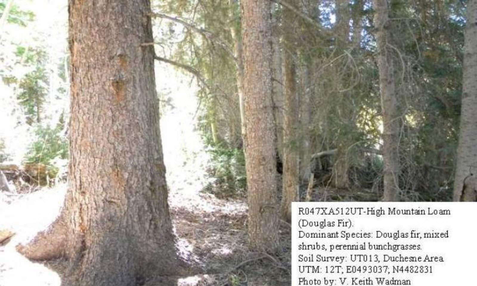
This ecological site occurs in the Wasatch Mountains Unit of the Middle Rocky Mountains Province of the Rocky Mountain System and evolved under all the ecological conditions and the natural influences of herbivory, fire and climate associated with that province. This site occurs on moderate to steep slopes (10 to 60%) and can occur on all aspects. It is usually found on high elevation mountain slopes and ledges. Species composition is generally dominated by an overstory canopy of Douglas fir. A wide mixture of shrubs occur in the understory with common juniper and Saskatoon serviceberry most dominant. Mountain snowberry, grouse whortleberry and alderleaf mountain mahogany are other common shrub species. Ross sedge, blue wildrye and fringed brome are dominant herbaceous species. A wide diversity of perennial forbs are also present.
This sites high elevations, short growing season, and cobbly or gravelly soils, combined with its steep slopes limit its availability for livestock grazing. Grazing is usually limited to mid and late season cattle grazing and to bands of sheep that quickly move through the site during the summer months.
Evidence indicates that this site historically maintained a long burn cycle (150-200 years or more). Following a fire, Douglas fir and non-sprouting shrub species are removed or much reduced and sprouting shrubs and herbaceous species often dominate the site for a period of years. Over time, Douglas fir, and in some places some aspen, becomes reestablished on the burned areas and the site typically moves through several seral communities including that of sapling, pole, immature forest, mature forest and eventually to an old or overmature forest type if fire is excluded for very long periods of time. Logging has been observed in some locations, but it is usually restricted to flatter slopes and easily accessible locations. Following logging events the remaining immature Douglas fir again moves through the mature and overmature community stages.
As vegetative communities respond to changes caused by natural or man made events that cause them to cross ecological thresholds, a return to previous states may not be possible. The amount of effort needed to affect desired vegetative shifts depends on a sites present biotic and abiotic features and the desired results.
The following State and Transition diagram depicts the most common plant communities found on this ecological site. It does not necessarily depict all the plant communities that can occur, but does show the most prevalent and repeatable. As more data are collected, some of these plant communities may be revised or removed, and new ones added. These descriptions capture the current knowledge and experience at the time of this revision.
State and transition model

More interactive model formats are also available.
View Interactive Models
More interactive model formats are also available.
View Interactive Models
Click on state and transition labels to scroll to the respective text
| T1A | - | This transition occurs when various disturbances such as road building, pipeline construction or fence-line clearing provides and opportunity for non-native species to become established. |
|---|---|---|
| T2A | - | This transition occurs when timber logging and its associated activities, including road building and skid trail development, removes mature and over-mature Douglas fir trees from the site and provides an opportunity for non-native species to increase. |
| R3A | - | This restoration pathway occurs following logging activities when the site is allowed to recover naturally. |
State 1 submodel, plant communities
| 1.1B | - | This community pathway occurs when wildfire removes the Douglas fir overstory. This event can be exacerbated by drought, insect damage or disease. |
|---|---|---|
| 1.1A | - | This community pathway occurs when fire is excluded from the plant community for long periods of time. |
| 1.2A | - | This community pathway occurs when fire is excluded from the plant community for long periods of time. |
| 1.3A | - | This community pathway occurs when fire is excluded from the plant community for long periods of time. |
| 1.3B | - | This community pathway occurs when wildfire removes the Douglas fir overstory. This event can be exacerbated by drought, insect damage or disease. |
| 1.4A | - | This community pathway occurs when insect damage or disease kills old trees and allows the community to return to a community phase 1.1 type with snags present. |
| 1.4B | - | This community pathway occurs when wildfire removed the Douglas fir overstory. This event can be exacerbated by drought, insect damage or disease. |
State 2 submodel, plant communities
| 2.1B | - | This community pathway occurs when wildfire removes the Douglas fir overstory. This event can be exacerbated by drought, insect damage or disease. |
|---|---|---|
| 2.1A | - | This community pathway occurs when fire is excluded from the plant community for long periods of time. |
| 2.2A | - | This community pathway occurs when fire is excluded from the plant community for long periods of time. |
| 2.3A | - | This community pathway occurs when fire is excluded from the plant community for long periods of time. |
| 2.3B | - | This community pathway occurs when wildfire removes the Douglas fir overstory. This event can be exacerbated by drought, insect damage or disease. |
| 2.4B | - | This community pathway occurs when insect damage or disease kills old trees and allows the community to return to a community phase 2.1 type with snags present |
| 2.4A | - | This community pathway occurs when wildfire removes the Douglas fir overstory. This event can be exacerbated by drought, insect damage or disease. |
State 3 submodel, plant communities
State 1
Reference State
This Reference State (State 1) describes the biotic communities that may become established on the High Mountain Loam (Douglas Fir) ecological site if all successional sequences are completed under natural disturbance conditions. Species composition is generally dominated by an overstory canopy of Douglas fir. A wide mixture of shrubs occur in the understory with common juniper and Saskatoon serviceberry most dominant. Mountain snowberry, grouse whortleberry and alderleaf mountain mahogany are other common shrub species. Ross sedge, blue wildrye and fringed brome are dominant herbaceous species. A wide diversity of perennial forbs are also present. The seral communities described in the Reference State are open canopy, seedling, sapling, pole, immature forest, mature forest, and old or over-mature forest type if fire is excluded for very long periods of time. The primary disturbance mechanisms in the Reference State (1) are overstory canopy density, weather fluctuations, and fire, or lack of fire. The Reference State is self-sustaining and resistant to change beyond it's normal seral community types due to adaptation to natural disturbances and a high resilience following those disturbances. When natural disturbances such as fire do occur, the rate of recovery can be quite variable. Reference State: Plant communities influenced by Douglas fir canopy density, long-term weather fluctuations, and periodic fire. Indicators: A community dominated by Douglas fir with understory Douglas fir reproduction, and sprouting shrubs including alderleaf mountain mahogany, grouse whortleberry and Saskatoon serviceberry. The density of the overstory canopy determines the amount and composition of the other native perennial grasses, grass-likes and forbs that may be present. Feedbacks: Natural fluctuations in weather patterns that allow for a self-sustaining mix of a Douglas fir, shrub and native grass and grass-like species in the community. Insect herbivory, more frequent fires, or other disturbances may allow for the establishment of invasive species. At-risk Community Phase: All communities are at risk when native plants are stressed and nutrients become available for invasive plants to establish. Trigger: The establishment of invasive plant species
Community 1.1
Mature Douglas Fir Forest Community Phase

Figure 3. Community Phase 1.1
The Mature Douglas Fir Forest Community Phase is characterized by an overstory canopy dominated by mature Douglas fir. A wide mixture of shrubs are found in the understory with common juniper and Saskatoon serviceberry, along with Douglas fir reproduction, being most dominant. Mountain snowberry, grouse whortleberry and alderleaf mountain mahogany are other common shrub species. Ross sedge, blue wildrye and fringed brome are dominant grass and grass-like species. A wide diversity of perennial forbs are also present. Air dry composition of this site is approximately 15 percent grasses, 10 percent forbs, 20 percent shrubs and Douglas fir reproduction and 55 mature Douglas fir. Bare ground is variable (5 to 30 percent) depending on litter and biological crust cover, which are also variable (10 to 40 percent) and surface rock fragments (0 to 50 percent). Thick duff layers are present on some sites, completely covering the forest floor with needles and twigs. The following tables provide an example of the typical vegetative floristics of a community phase 1.1 plant community.
Figure 4. Annual production by plant type (representative values) or group (midpoint values)
Table 5. Annual production by plant type
| Plant type | Low (kg/hectare) |
Representative value (kg/hectare) |
High (kg/hectare) |
|---|---|---|---|
| Tree | 392 | 560 | 841 |
| Shrub/Vine | 179 | 202 | 224 |
| Grass/Grasslike | 112 | 157 | 202 |
| Forb | 101 | 146 | 191 |
| Total | 784 | 1065 | 1458 |
Table 6. Ground cover
| Tree foliar cover | 25-50% |
|---|---|
| Shrub/vine/liana foliar cover | 15-20% |
| Grass/grasslike foliar cover | 10-15% |
| Forb foliar cover | 5-15% |
| Non-vascular plants | 0% |
| Biological crusts | 0% |
| Litter | 20-60% |
| Surface fragments >0.25" and <=3" | 0% |
| Surface fragments >3" | 0% |
| Bedrock | 0% |
| Water | 0% |
| Bare ground | 5-20% |
Table 7. Canopy structure (% cover)
| Height Above Ground (m) | Tree | Shrub/Vine | Grass/ Grasslike |
Forb |
|---|---|---|---|---|
| <0.15 | – | – | 10-15% | 5-10% |
| >0.15 <= 0.3 | – | 5-10% | 5-10% | 5-10% |
| >0.3 <= 0.6 | 10-15% | 10-20% | 2-5% | 2-5% |
| >0.6 <= 1.4 | 10-15% | 5-10% | – | – |
| >1.4 <= 4 | 10-15% | 2-5% | – | – |
| >4 <= 12 | 15-29% | – | – | – |
| >12 <= 24 | 5-10% | – | – | – |
| >24 <= 37 | 5-10% | – | – | – |
| >37 | – | – | – | – |
Community 1.2
Douglas Fir- Open/Seedling/Sapling Forest Community Phase
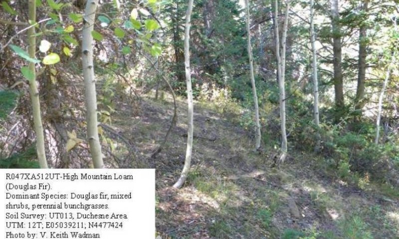
Figure 5. Community Phase 1.2
This Community Phase is typically found following significant natural disturbances including wildfire, disease or insect damage. It is characterized by the removal of the Douglas fir overstory canopy. Douglas fir seedlings and saplings are increasing in the community. Aspen is often present and may dominate a specific aspect within the site for many years. Young Douglas fir prefer shade, which aspen and native shrubs provide. A mixture of shrubs are found in the understory with common juniper and Saskatoon serviceberry being most dominant. Mountain snowberry, grouse whortleberry and alderleaf mountain mahogany are other common shrub species. Ross sedge, blue wildrye and fringed brome are dominant grass and grass-like species. A wide diversity of perennial forbs are also present. Air dry composition of this site is approximately 15 percent grasses, 10 percent forbs, 20 percent shrubs and Douglas fir reproduction and 55 mature Douglas fir. Bare ground is variable (5 to 30 percent) depending on litter and biological crust cover, which are also variable (10 to 40 percent) and surface rock fragments (0 to 50 percent). Thick duff layers are present on some sites, completely covering the forest floor with needles and twigs. The following tables provide an example the typical vegetative floristics of a community phase 1.2 plant community.
Figure 6. Annual production by plant type (representative values) or group (midpoint values)
Table 8. Annual production by plant type
| Plant type | Low (kg/hectare) |
Representative value (kg/hectare) |
High (kg/hectare) |
|---|---|---|---|
| Tree | 224 | 336 | 448 |
| Grass/Grasslike | 224 | 269 | 370 |
| Shrub/Vine | 291 | 314 | 336 |
| Forb | 101 | 146 | 191 |
| Total | 840 | 1065 | 1345 |
Table 9. Ground cover
| Tree foliar cover | 20-35% |
|---|---|
| Shrub/vine/liana foliar cover | 20-25% |
| Grass/grasslike foliar cover | 10-15% |
| Forb foliar cover | 5-15% |
| Non-vascular plants | 0% |
| Biological crusts | 0% |
| Litter | 20-60% |
| Surface fragments >0.25" and <=3" | 0% |
| Surface fragments >3" | 0% |
| Bedrock | 0% |
| Water | 0% |
| Bare ground | 5-20% |
Table 10. Canopy structure (% cover)
| Height Above Ground (m) | Tree | Shrub/Vine | Grass/ Grasslike |
Forb |
|---|---|---|---|---|
| <0.15 | – | – | 10-15% | 5-10% |
| >0.15 <= 0.3 | – | 5-10% | 5-10% | 5-10% |
| >0.3 <= 0.6 | 10-15% | 10-20% | 2-5% | 2-5% |
| >0.6 <= 1.4 | 10-15% | 5-10% | – | – |
| >1.4 <= 4 | 10-15% | 2-5% | – | – |
| >4 <= 12 | – | – | – | – |
| >12 <= 24 | – | – | – | – |
| >24 <= 37 | – | – | – | – |
| >37 | – | – | – | – |
Community 1.3
Douglas Fir- Pole/Immature Forest Community Phases.
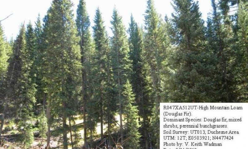
Figure 7. Community Phase 1.3
This community phase is typically found many years following significant natural disturbances including wildfire, disease or insect damage. It is characterized by a partial recovery of the Douglas fir overstory canopy. Pole and/or immature sized trees are present and are beginning to once again dominant the community. Aspen may also still be present but is being replaced by Douglas fir. A wide mixture of shrubs are found in the understory with common juniper and Saskatoon serviceberry being most dominant. Mountain snowberry, grouse whortleberry and alderleaf mountain mahogany are other common shrub species. Ross sedge, blue wildrye and fringed brome are dominant herbaceous species. A wide diversity of perennial forbs are also present. Air dry composition of this site is approximately 20 percent grasses, 15 percent forbs, 25 percent shrubs and Douglas fir reproduction and 50 pole and immature Douglas fir. Bare ground is variable (5-30%) depending on litter and biological crust cover, which are also variable (10-40%) and surface rock fragments (0-50%). Thick duff layers are present on some sites, completely covering the forest floor with needles and twigs. The following tables provide an example the typical vegetative floristics of a community phase 1.3 plant community.
Figure 8. Annual production by plant type (representative values) or group (midpoint values)
Table 11. Annual production by plant type
| Plant type | Low (kg/hectare) |
Representative value (kg/hectare) |
High (kg/hectare) |
|---|---|---|---|
| Tree | 336 | 448 | 560 |
| Grass/Grasslike | 168 | 213 | 314 |
| Shrub/Vine | 235 | 258 | 280 |
| Forb | 101 | 146 | 191 |
| Total | 840 | 1065 | 1345 |
Table 12. Ground cover
| Tree foliar cover | 30-40% |
|---|---|
| Shrub/vine/liana foliar cover | 20-25% |
| Grass/grasslike foliar cover | 10-15% |
| Forb foliar cover | 5-15% |
| Non-vascular plants | 0% |
| Biological crusts | 0% |
| Litter | 20-60% |
| Surface fragments >0.25" and <=3" | 0% |
| Surface fragments >3" | 0% |
| Bedrock | 0% |
| Water | 0% |
| Bare ground | 5-20% |
Table 13. Canopy structure (% cover)
| Height Above Ground (m) | Tree | Shrub/Vine | Grass/ Grasslike |
Forb |
|---|---|---|---|---|
| <0.15 | – | – | 10-15% | 5-10% |
| >0.15 <= 0.3 | – | 5-10% | 5-10% | 5-10% |
| >0.3 <= 0.6 | 10-15% | 10-20% | 2-5% | 2-5% |
| >0.6 <= 1.4 | 10-15% | 5-10% | – | – |
| >1.4 <= 4 | 10-15% | 2-5% | – | – |
| >4 <= 12 | 10-15% | – | – | – |
| >12 <= 24 | 10-15% | – | – | – |
| >24 <= 37 | – | – | – | – |
| >37 | – | – | – | – |
Community 1.4
Over-Mature Douglas Fir Forest Community Phase.
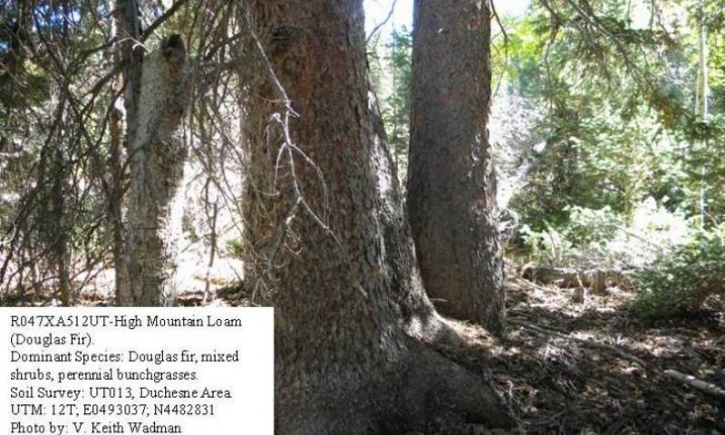
Figure 9. Community Phase 1.4
This community phase is characterized by an overstory canopy dominated by a decadent, over-mature stand of Douglas fir. A mixture of shade tolerant of shrubs are found in the understory with common juniper and Saskatoon serviceberry, along with Douglas fir reproduction, occurring most often. Lesser amounts of Mountain snowberry, grouse whortleberry and alderleaf mountain mahogany are also present. Ross sedge, blue wildrye and fringed brome are reduced in the shand but are still the most common herbaceous species. A diversity of perennial forbs are also present. Air dry composition of this site is approximately 5 percent grasses, 10 percent forbs, 15 percent shrubs and Douglas fir reproduction and 70% mature Douglas fir. Bare ground is variable (5-30%) depending on litter and biological crust cover, which are also variable (10-40%) and surface rock fragments (0-50%). Thick duff layers are present on some sites, completely covering the forest floor with needles and twigs. The following tables provide an example the typical vegetative floristics of a community phase 1.4 plant community.
Figure 10. Annual production by plant type (representative values) or group (midpoint values)
Table 14. Annual production by plant type
| Plant type | Low (kg/hectare) |
Representative value (kg/hectare) |
High (kg/hectare) |
|---|---|---|---|
| Tree | 504 | 673 | 953 |
| Forb | 101 | 146 | 191 |
| Shrub/Vine | 123 | 146 | 168 |
| Grass/Grasslike | 56 | 101 | 146 |
| Total | 784 | 1066 | 1458 |
Table 15. Ground cover
| Tree foliar cover | 35-60% |
|---|---|
| Shrub/vine/liana foliar cover | 15-20% |
| Grass/grasslike foliar cover | 10-15% |
| Forb foliar cover | 5-15% |
| Non-vascular plants | 0% |
| Biological crusts | 0% |
| Litter | 20-60% |
| Surface fragments >0.25" and <=3" | 0% |
| Surface fragments >3" | 0% |
| Bedrock | 0% |
| Water | 0% |
| Bare ground | 5-20% |
Table 16. Canopy structure (% cover)
| Height Above Ground (m) | Tree | Shrub/Vine | Grass/ Grasslike |
Forb |
|---|---|---|---|---|
| <0.15 | – | – | 10-15% | 5-10% |
| >0.15 <= 0.3 | – | 5-10% | 5-10% | 5-10% |
| >0.3 <= 0.6 | 10-15% | 10-20% | 2-5% | 2-5% |
| >0.6 <= 1.4 | 10-15% | 5-10% | – | – |
| >1.4 <= 4 | 10-15% | 2-5% | – | – |
| >4 <= 12 | 15-29% | – | – | – |
| >12 <= 24 | 5-10% | – | – | – |
| >24 <= 37 | 5-10% | – | – | – |
| >37 | – | – | – | – |
Pathway 1.1B
Community 1.1 to 1.2
This community pathway occurs when wildfire removes the Douglas fir overstory. This event can be exacerbated by drought, insect damage or disease.
Pathway 1.1A
Community 1.1 to 1.4
This community pathway occurs when fire is excluded from the plant community for long periods of time.
Pathway 1.2A
Community 1.2 to 1.3
This community pathway occurs when fire is excluded from the plant community for long periods of time.
Pathway 1.3A
Community 1.3 to 1.1
This community pathway occurs when fire is excluded from the plant community for long periods of time.
Pathway 1.3B
Community 1.3 to 1.2
This community pathway occurs when wildfire removes the Douglas fir overstory. This event can be exacerbated by drought, insect damage or disease.
Pathway 1.4A
Community 1.4 to 1.1
This community pathway occurs when insect damage or disease kills old trees and allows the community to return to a community phase 1.1 type with snags present.
Pathway 1.4B
Community 1.4 to 1.2
This community pathway occurs when wildfire removed the Douglas fir overstory. This event can be exacerbated by drought, insect damage or disease.
State 2
Current Potential State
The Current Potential State is similar to the Reference State; however, minor amounts of invasive species are present in the community phases. This condition has not been well documented and so community phases in this State are based on possible community dynamics and not documented facts. This State describes the biotic communities that may become established on the High Mountain Loam (Douglas Fir) ecological site if all successional sequences are completed under natural disturbance conditions with the presence of a non-native species. Species composition is generally dominated by an overstory canopy of Douglas fir. A wide mixture of shrubs occur in the understory with common juniper and Saskatoon serviceberry most dominant. Mountain snowberry, grouse whortleberry and alderleaf mountain mahogany are other common shrub species. Ross sedge, blue wildrye and fringed brome are dominant herbaceous species. A wide diversity of perennial forbs are also present. Seral communities are described in the Current Potential State, including sapling, pole, immature forest, mature forest, and old or over-mature forest type if fire is excluded for very long periods of time. The primary disturbance mechanisms are overstory canopy density, weather fluctuations and fire or lack of fire. The Current Potential State is still self-sustaining but has a lower resistance to change due to a reduced resilience to disturbances. When disturbances do occur, the rate of recovery can be highly variable. Current Potential State: Plant communities influenced by wildlife browsing, insect herbivory, weather fluctuations, fire periods and surface disturbances. Indicators: A community dominated by Douglas fir with understory Douglas fir reproduction, and sprouting shrubs including alderleaf mountain mahogany, grouse whortleberry and Saskatoon serviceberry. The density of the overstory canopy determines the amount and composition of the other native perennial grasses, grass-likes and forbs that may be present. Feedbacks: Natural fluctuations in weather patterns that allow for a self-sustaining mix of a Douglas fir, shrub, native grass, and grass-like community. Insect herbivory, more frequent fires, or other disturbances may allow for the establishment of invasive species. At-risk Community Phase: All communities are at risk when native plants are stressed and nutrients become available for invasive plants to establish. Trigger: The establishment of invasive plant species
Community 2.1
Mature Douglas Fir, Non-Native Herbaceous Community Phase
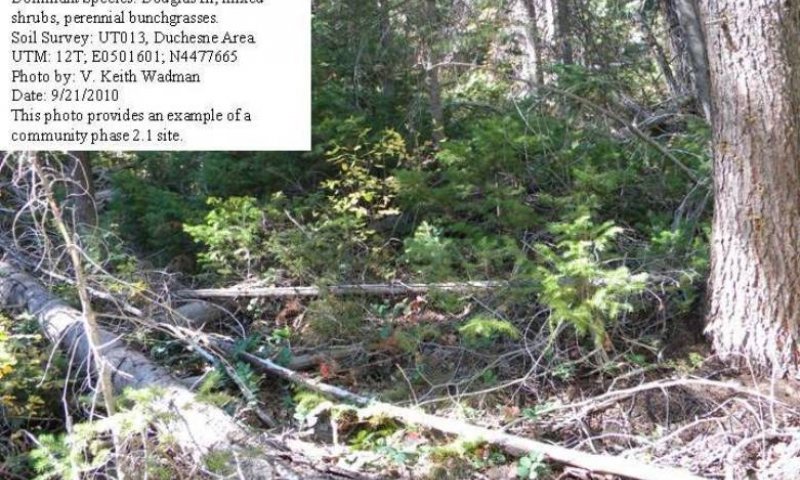
Figure 11. Community Phase 2.1
This community phase is characterized by an overstory canopy dominated by mature Douglas fir. A wide mixture of shrubs are found in the understory with common juniper and Saskatoon serviceberry, along with Douglas fir reproduction, being most dominant. Mountain snowberry, grouse whortleberry and alderleaf mountain mahogany are other common shrub species. Ross sedge, blue wildrye and fringed brome are dominant grass and grass-like species. A wide diversity of perennial forbs are also present. Non-native herbaceous species such as orchardgrass, Kentucky bluegrass and smooth brome are potentially present in the community. This potential increases where roadcuts or other disturbance has impacted the site. Air dry composition is approximately 15 percent grasses, 10 percent forbs, 20 percent shrubs and Douglas fir reproduction and 55 percent mature Douglas fir. Bare ground is variable (5 to 30 percent) depending on litter and biological crust cover, which are also variable (10 to 40 percent) and surface rock fragments (up to 50 percent). Thick duff layers are present on some sites, covering the forest floor with needles and twigs. The following tables provide an example of the typical vegetative floristics of a community phase 2.1 plant community.
Figure 12. Annual production by plant type (representative values) or group (midpoint values)
Table 17. Annual production by plant type
| Plant type | Low (kg/hectare) |
Representative value (kg/hectare) |
High (kg/hectare) |
|---|---|---|---|
| Tree | 392 | 560 | 841 |
| Shrub/Vine | 179 | 202 | 224 |
| Grass/Grasslike | 112 | 157 | 202 |
| Forb | 101 | 146 | 191 |
| Total | 784 | 1065 | 1458 |
Table 18. Ground cover
| Tree foliar cover | 25-50% |
|---|---|
| Shrub/vine/liana foliar cover | 15-20% |
| Grass/grasslike foliar cover | 10-15% |
| Forb foliar cover | 5-15% |
| Non-vascular plants | 0% |
| Biological crusts | 0% |
| Litter | 20-60% |
| Surface fragments >0.25" and <=3" | 0% |
| Surface fragments >3" | 0% |
| Bedrock | 0% |
| Water | 0% |
| Bare ground | 5-20% |
Table 19. Canopy structure (% cover)
| Height Above Ground (m) | Tree | Shrub/Vine | Grass/ Grasslike |
Forb |
|---|---|---|---|---|
| <0.15 | – | – | 10-15% | 5-10% |
| >0.15 <= 0.3 | – | 5-10% | 5-10% | 5-10% |
| >0.3 <= 0.6 | 10-15% | 10-20% | 2-5% | 2-5% |
| >0.6 <= 1.4 | 10-15% | 5-10% | – | – |
| >1.4 <= 4 | 10-15% | 2-5% | – | – |
| >4 <= 12 | 15-29% | – | – | – |
| >12 <= 24 | 5-10% | – | – | – |
| >24 <= 37 | 5-10% | – | – | – |
| >37 | – | – | – | – |
Community 2.2
Douglas Fir- Open/Seedling/Sapling Non-Native Herbaceous Community Phase
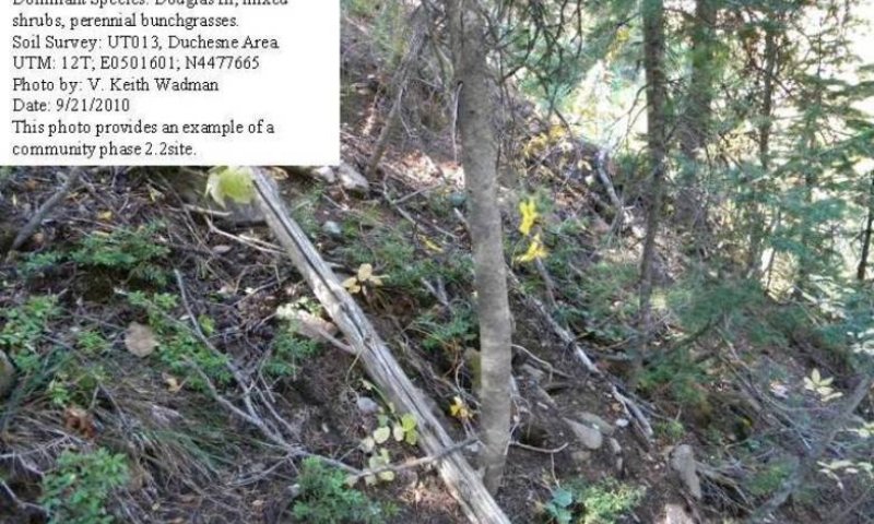
Figure 13. Community Phase 2.2
This community phase is typically found following significant natural or man caused disturbances including road building, wildfire, disease, or insect damage. It is characterized by the removal of the Douglas fir overstory canopy. Douglas fir seedlings and saplings are present and increasing in the community. Aspen is often present and may dominate the site for many years. Young Douglas fir prefer shade, the aspen and native shrubs help provide shade in this community. A mixture of shrubs are found in the understory with common juniper and Saskatoon serviceberry being most dominant. Mountain snowberry, grouse whortleberry and alderleaf mountain mahogany are other common shrub species. Ross sedge, blue wildrye and fringed brome are dominant grass and grass-like species. A wide diversity of perennial forbs are also present. Non-native species such as orchardgrass, Kentucky bluegrass and smooth brome may also be present. Air dry composition is approximately 15 percent grasses, 10 percent forbs, 20 percent shrubs and Douglas fir reproduction and 55 mature Douglas fir. Bare ground is variable (5 to 30 percent) depending on litter and biological crust cover, which are also variable (10 to 40 percent) and surface rock fragments (up to 50 percent). Thick duff layers are present on some sites, completely covering the forest floor with needles and twigs. The following tables provide an example of the typical vegetative floristics of a community phase 2.2 plant community.
Figure 14. Annual production by plant type (representative values) or group (midpoint values)
Table 20. Annual production by plant type
| Plant type | Low (kg/hectare) |
Representative value (kg/hectare) |
High (kg/hectare) |
|---|---|---|---|
| Tree | 224 | 336 | 448 |
| Grass/Grasslike | 224 | 269 | 370 |
| Shrub/Vine | 291 | 314 | 336 |
| Forb | 101 | 146 | 191 |
| Total | 840 | 1065 | 1345 |
Table 21. Ground cover
| Tree foliar cover | 20-35% |
|---|---|
| Shrub/vine/liana foliar cover | 20-25% |
| Grass/grasslike foliar cover | 10-15% |
| Forb foliar cover | 5-15% |
| Non-vascular plants | 0% |
| Biological crusts | 0% |
| Litter | 20-60% |
| Surface fragments >0.25" and <=3" | 0% |
| Surface fragments >3" | 0% |
| Bedrock | 0% |
| Water | 0% |
| Bare ground | 5-20% |
Table 22. Canopy structure (% cover)
| Height Above Ground (m) | Tree | Shrub/Vine | Grass/ Grasslike |
Forb |
|---|---|---|---|---|
| <0.15 | – | – | 10-15% | 5-10% |
| >0.15 <= 0.3 | – | 5-10% | 5-10% | 5-10% |
| >0.3 <= 0.6 | 10-15% | 10-20% | 2-5% | 2-5% |
| >0.6 <= 1.4 | 10-15% | 5-10% | – | – |
| >1.4 <= 4 | 10-15% | 2-5% | – | – |
| >4 <= 12 | – | – | – | – |
| >12 <= 24 | – | – | – | – |
| >24 <= 37 | – | – | – | – |
| >37 | – | – | – | – |
Community 2.3
Douglas Fir- Pole/Immature Forest, Non-Native Herbaceous Community Phase
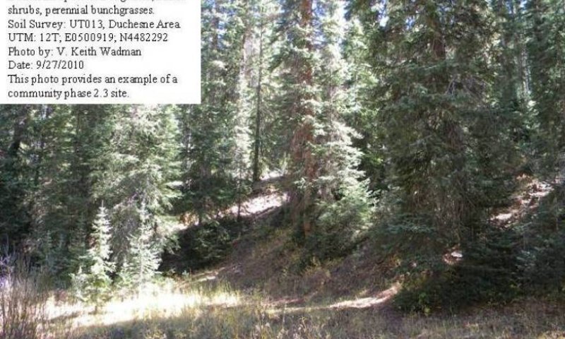
Figure 15. Community Phase 2.3
This community phase is typically found many years following significant natural or man caused disturbances including road building, wildfire, disease or insect damage. It is characterized by a partial recovery of the Douglas fir overstory canopy. Pole-sized and immature trees are beginning to once again dominant the community. Aspen may still be present but is being replaced by Douglas fir. A mixture of shrubs are found in the understory with common juniper and Saskatoon serviceberry being most dominant. Mountain snowberry, grouse whortleberry and alderleaf mountain mahogany are other common shrub species. Ross sedge, blue wildrye and fringed brome are dominant grass and grass-like species. A wide diversity of perennial forbs are also present. Non-native species including orchardgrass, Kentucky bluegrass and smooth brome may be found on the site. Air dry composition of this site is approximately 20 percent grasses, 15 percent forbs, 25 percent shrubs and Douglas fir reproduction and 50 pole and immature Douglas fir. Bare ground is variable (5 to 30 percent) depending on litter and biological crust cover, which are also variable (10 to 40 percent) and surface rock fragments (0 to 50 percent). Thick duff layers are present on some sites, completely covering the forest floor with needles and twigs. The following tables provide an example of the typical vegetative floristics of a community phase 2.3 plant community.
Figure 16. Annual production by plant type (representative values) or group (midpoint values)
Table 23. Annual production by plant type
| Plant type | Low (kg/hectare) |
Representative value (kg/hectare) |
High (kg/hectare) |
|---|---|---|---|
| Tree | 336 | 448 | 560 |
| Grass/Grasslike | 168 | 213 | 314 |
| Shrub/Vine | 235 | 258 | 280 |
| Forb | 101 | 146 | 191 |
| Total | 840 | 1065 | 1345 |
Table 24. Ground cover
| Tree foliar cover | 30-40% |
|---|---|
| Shrub/vine/liana foliar cover | 20-25% |
| Grass/grasslike foliar cover | 10-15% |
| Forb foliar cover | 5-15% |
| Non-vascular plants | 0% |
| Biological crusts | 0% |
| Litter | 20-60% |
| Surface fragments >0.25" and <=3" | 0% |
| Surface fragments >3" | 0% |
| Bedrock | 0% |
| Water | 0% |
| Bare ground | 5-20% |
Table 25. Canopy structure (% cover)
| Height Above Ground (m) | Tree | Shrub/Vine | Grass/ Grasslike |
Forb |
|---|---|---|---|---|
| <0.15 | – | – | 10-15% | 5-10% |
| >0.15 <= 0.3 | – | 5-10% | 5-10% | 5-10% |
| >0.3 <= 0.6 | 10-15% | 10-20% | 2-5% | 2-5% |
| >0.6 <= 1.4 | 10-15% | 5-10% | – | – |
| >1.4 <= 4 | 10-15% | 2-5% | – | – |
| >4 <= 12 | 10-15% | – | – | – |
| >12 <= 24 | 10-15% | – | – | – |
| >24 <= 37 | – | – | – | – |
| >37 | – | – | – | – |
Community 2.4
Over-Mature Douglas Fir, Non-Native Herbaceous Community Phase
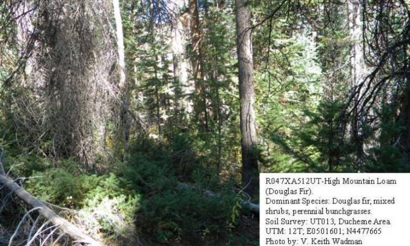
Figure 17. Community Phase 2.4
This community phase is characterized by an overstory canopy dominated by a decadent, over-mature stand of Douglas fir. A mixture of shade tolerant shrubs are found in the understory with common juniper and Saskatoon serviceberry, along with Douglas fir reproduction, occurring most often. Lesser amounts of mountain snowberry, grouse whortleberry and alderleaf mountain mahogany are also present. Ross sedge, blue wildrye and fringed brome are reduced in the stand but are still the most common grass and grass-like species. A diversity of perennial forbs are also present. Minor amounts of non-native species including orchardgrass, Kentucky bluegrass and smooth brome may also be present. Air dry composition is approximately 5 percent grasses, 10 percent forbs, 15 percent shrubs and Douglas fir reproduction and 70 percent mature Douglas fir. Bare ground is variable (5 to 30 percent) depending on litter and biological crust cover, which are also variable (10 to 40 percent) and surface rock fragments (up to 50 percent). Thick duff layers are present on some sites, completely covering the forest floor with needles and twigs. The following tables provide an example of the typical vegetative floristics of a community phase 2.4 plant community.
Figure 18. Annual production by plant type (representative values) or group (midpoint values)
Table 26. Annual production by plant type
| Plant type | Low (kg/hectare) |
Representative value (kg/hectare) |
High (kg/hectare) |
|---|---|---|---|
| Tree | 504 | 673 | 953 |
| Forb | 101 | 146 | 191 |
| Shrub/Vine | 123 | 146 | 168 |
| Grass/Grasslike | 56 | 101 | 146 |
| Total | 784 | 1066 | 1458 |
Table 27. Ground cover
| Tree foliar cover | 35-60% |
|---|---|
| Shrub/vine/liana foliar cover | 15-20% |
| Grass/grasslike foliar cover | 10-15% |
| Forb foliar cover | 5-15% |
| Non-vascular plants | 0% |
| Biological crusts | 0% |
| Litter | 20-60% |
| Surface fragments >0.25" and <=3" | 0% |
| Surface fragments >3" | 0% |
| Bedrock | 0% |
| Water | 0% |
| Bare ground | 5-20% |
Table 28. Canopy structure (% cover)
| Height Above Ground (m) | Tree | Shrub/Vine | Grass/ Grasslike |
Forb |
|---|---|---|---|---|
| <0.15 | – | – | 10-15% | 5-10% |
| >0.15 <= 0.3 | – | 5-10% | 5-10% | 5-10% |
| >0.3 <= 0.6 | 10-15% | 10-20% | 2-5% | 2-5% |
| >0.6 <= 1.4 | 10-15% | 5-10% | – | – |
| >1.4 <= 4 | 10-15% | 2-5% | – | – |
| >4 <= 12 | 15-29% | – | – | – |
| >12 <= 24 | 5-10% | – | – | – |
| >24 <= 37 | 5-10% | – | – | – |
| >37 | – | – | – | – |
Pathway 2.1B
Community 2.1 to 2.2
This community pathway occurs when wildfire removes the Douglas fir overstory. This event can be exacerbated by drought, insect damage or disease.
Pathway 2.1A
Community 2.1 to 2.4
This community pathway occurs when fire is excluded from the plant community for long periods of time.
Pathway 2.2A
Community 2.2 to 2.3
This community pathway occurs when fire is excluded from the plant community for long periods of time.
Pathway 2.3A
Community 2.3 to 2.1
This community pathway occurs when fire is excluded from the plant community for long periods of time.
Pathway 2.3B
Community 2.3 to 2.2
This community pathway occurs when wildfire removes the Douglas fir overstory. This event can be exacerbated by drought, insect damage or disease.
Pathway 2.4B
Community 2.4 to 2.1
This community pathway occurs when insect damage or disease kills old trees and allows the community to return to a community phase 2.1 type with snags present
Pathway 2.4A
Community 2.4 to 2.2
This community pathway occurs when wildfire removes the Douglas fir overstory. This event can be exacerbated by drought, insect damage or disease.
State 3
Logged/Disturbed State
The Logged/Disturbed State is similar to the Current Potential State; however, merchantable timber composed mostly of mature and old Douglas fir have been removed. Various amounts of invasive species are present in all community phases. This condition has not been well documented and so community phases in this State are based on possible community dynamics and not documented facts. Species composition is generally dominated by an immature canopy of Douglas fir. A wide mixture of shrubs occur in the understory with common juniper and Saskatoon serviceberry most dominant. Mountain snowberry, grouse whortleberry and alderleaf mountain mahogany are other common shrub species. Ross sedge, blue wildrye, and fringed brome are dominant grass and grass-like species. A wide diversity of perennial forbs are also present. Non-native species including orchardgrass, Kentucky bluegrass and smooth brome may also be present. These species could have been seeded as part of the site rehabilitation following the logging process. Logging will release younger Douglas fir trees and will give the site the look of an immature forest. Site will return to a mature and finally an old or over-mature forest type if fire is excluded for very long periods of time. The primary disturbance mechanisms are logging, road building or other man caused activities, weather fluctuations and fire or lack of fire. The Logged/Disturbed State is still self-sustaining but has a lower resistance to change due to a reduced resilience to disturbances. When disturbances do occur, the rate of recovery can be highly variable. Logged/Disturbed State: Plant communities influenced by man caused activities, wildlife browsing, insect herbivory, weather fluctuations, fire periods and surface disturbances. Indicators: A community dominated by immature Douglas fir with understory of Douglas fir reproduction, and shrubs including common juniper, alderleaf mountain mahogany, grouse whortleberry and Saskatoon serviceberry. The density of the overstory canopy determines the amount and composition of the other native perennial grasses, grass-likes and forbs that may be present. Feedbacks: Natural fluctuations in weather patterns that allow for a self-sustaining mix of a Douglas fir, shrub, native grass, and grass-like species in the community. Insect herbivory, more frequent fires, or other disturbances may allow for the establishment of invasive species. At-risk Community Phase: All communities are at risk when native plants are stressed and nutrients become available for invasive plants to establish. Trigger: The increase of invasive plant species
Community 3.1
Logged Douglas Fir- Pole/Immature Forest, Non-Native Herbaceous Community Phase

Figure 19. Community Phase 3.1
This community phase is typically found following logging or other man caused activity such as road building. It is characterized by a partial stand of Douglas fir. Pole and immature sized trees are present and are beginning to once again dominate the community. Aspen may also be present in the stand. A wide mixture of shrubs are found in the understory with common juniper and Saskatoon serviceberry being most dominant. Mountain snowberry, grouse whortleberry and alderleaf mountain mahogany are other common shrub species. Ross sedge, blue wildrye and fringed brome are dominant herbaceous species. A wide diversity of perennial forbs are also present. Non-native species including orchardgrass, Kentucky bluegrass and smooth brome may be in the community. Air dry composition of this site is approximately 25 percent grasses, 20 percent forbs, 30 percent shrubs and Douglas fir reproduction and 50 percent pole and immature Douglas fir. Bare ground is variable (5 to 30 percent) depending on litter and biological crust cover, which are also variable (10 to 40 percent) and surface rock fragments (up to 50 percent). Thick duff layers are present on some sites, covering the forest floor with needles and twigs. The following tables provide an example the typical vegetative floristics of a community phase 3.1 plant community.
Figure 20. Annual production by plant type (representative values) or group (midpoint values)
Table 29. Annual production by plant type
| Plant type | Low (kg/hectare) |
Representative value (kg/hectare) |
High (kg/hectare) |
|---|---|---|---|
| Tree | 280 | 392 | 504 |
| Grass/Grasslike | 224 | 269 | 370 |
| Shrub/Vine | 235 | 258 | 280 |
| Forb | 101 | 146 | 191 |
| Total | 840 | 1065 | 1345 |
Table 30. Ground cover
| Tree foliar cover | 30-40% |
|---|---|
| Shrub/vine/liana foliar cover | 20-25% |
| Grass/grasslike foliar cover | 10-15% |
| Forb foliar cover | 5-15% |
| Non-vascular plants | 0% |
| Biological crusts | 0% |
| Litter | 20-60% |
| Surface fragments >0.25" and <=3" | 0% |
| Surface fragments >3" | 0% |
| Bedrock | 0% |
| Water | 0% |
| Bare ground | 5-20% |
Table 31. Canopy structure (% cover)
| Height Above Ground (m) | Tree | Shrub/Vine | Grass/ Grasslike |
Forb |
|---|---|---|---|---|
| <0.15 | – | – | 10-15% | 5-10% |
| >0.15 <= 0.3 | – | 5-10% | 5-10% | 5-10% |
| >0.3 <= 0.6 | 10-15% | 10-20% | 2-5% | 2-5% |
| >0.6 <= 1.4 | 10-15% | 5-10% | – | – |
| >1.4 <= 4 | 10-15% | 2-5% | – | – |
| >4 <= 12 | 10-15% | – | – | – |
| >12 <= 24 | 10-15% | – | – | – |
| >24 <= 37 | – | – | – | – |
| >37 | – | – | – | – |
Transition T1A
State 1 to 2
This transition occurs when various disturbances such as road building, pipeline construction or fence-line clearing provides and opportunity for non-native species to become established. Seeding of these species could be a normal part of these activities. Once non-native species are established, a threshold has been crossed.
Transition T2A
State 2 to 3
This transition occurs when timber logging and its associated activities, including road building and skid trail development, removes mature and over-mature Douglas fir trees from the site and provides an opportunity for non-native species to increase. Seeding species such as orchardgrass and smooth brome would often be a normal part of these activities. Once the site is logged, a threshold has been crossed.
Restoration pathway R3A
State 3 to 2
This restoration pathway occurs following logging activities when the site is allowed to recover naturally. Pole sized and immature Douglas fir trees are increasing in dominance. Seeded, non-native herbaceous species where present, are will established.
Additional community tables
Table 32. Community 1.1 plant community composition
| Group | Common name | Symbol | Scientific name | Annual production (kg/hectare) | Foliar cover (%) | |
|---|---|---|---|---|---|---|
|
Grass/Grasslike
|
||||||
| 1 | Dominant Grasses | 84–140 | ||||
| Ross' sedge | CARO5 | Carex rossii | 45–67 | – | ||
| blue wildrye | ELGL | Elymus glaucus | 22–34 | – | ||
| fringed brome | BRCI2 | Bromus ciliatus | 22–34 | – | ||
| 2 | Sub-Dominant Grasses | 56–90 | ||||
| Letterman's needlegrass | ACLE9 | Achnatherum lettermanii | 11–22 | – | ||
| Columbia needlegrass | ACNE9 | Achnatherum nelsonii | 11–22 | – | ||
| mountain brome | BRMA4 | Bromus marginatus | 11–22 | – | ||
| Idaho fescue | FEID | Festuca idahoensis | 11–22 | – | ||
| sheep fescue | FEOV | Festuca ovina | 11–22 | – | ||
| muttongrass | POFE | Poa fendleriana | 11–22 | – | ||
| Wheeler bluegrass | PONE2 | Poa nervosa | 11–22 | – | ||
| spike trisetum | TRSP2 | Trisetum spicatum | 11–22 | – | ||
|
Forb
|
||||||
| 3 | Forbs | 67–101 | ||||
| common yarrow | ACMI2 | Achillea millefolium | 11–22 | – | ||
| littleleaf pussytoes | ANMI3 | Antennaria microphylla | 11–22 | – | ||
| heartleaf arnica | ARCO9 | Arnica cordifolia | 11–22 | – | ||
| timber milkvetch | ASMI9 | Astragalus miser | 11–22 | – | ||
| Wyoming Indian paintbrush | CALI4 | Castilleja linariifolia | 11–22 | – | ||
| miner's lettuce | CLPE | Claytonia perfoliata | 11–22 | – | ||
| gypsyflower | CYOF | Cynoglossum officinale | 11–22 | – | ||
| Virginia strawberry | FRVI | Fragaria virginiana | 11–22 | – | ||
| Richardson's geranium | GERI | Geranium richardsonii | 11–22 | – | ||
| fewflower pea | LAPA5 | Lathyrus pauciflorus | 11–22 | – | ||
| western sweetroot | OSOC | Osmorhiza occidentalis | 11–22 | – | ||
| western coneflower | RUOC2 | Rudbeckia occidentalis | 11–22 | – | ||
| western mountain aster | SYSP | Symphyotrichum spathulatum | 11–22 | – | ||
| Fendler's meadow-rue | THFE | Thalictrum fendleri | 11–22 | – | ||
| hookedspur violet | VIAD | Viola adunca | 11–22 | – | ||
|
Shrub/Vine
|
||||||
| 4 | Dominant Shrubs | 112–146 | ||||
| common juniper | JUCO6 | Juniperus communis | 67–90 | – | ||
| Saskatoon serviceberry | AMAL2 | Amelanchier alnifolia | 34–67 | – | ||
| alderleaf mountain mahogany | CEMO2 | Cercocarpus montanus | 34–67 | – | ||
| 5 | Sub-Dominant Shrubs | 78–112 | ||||
| mountain big sagebrush | ARTRV | Artemisia tridentata ssp. vaseyana | 34–67 | – | ||
| mountain snowberry | SYOR2 | Symphoricarpos oreophilus | 34–67 | – | ||
| grouse whortleberry | VASC | Vaccinium scoparium | 34–67 | – | ||
| yellow rabbitbrush | CHVIV4 | Chrysothamnus viscidiflorus ssp. viscidiflorus var. viscidiflorus | 22–45 | – | ||
| hairy clematis | CLHI | Clematis hirsutissima | 22–45 | – | ||
| creeping barberry | MARE11 | Mahonia repens | 22–45 | – | ||
| Oregon boxleaf | PAMY | Paxistima myrsinites | 22–45 | – | ||
| mallow ninebark | PHMA5 | Physocarpus malvaceus | 22–45 | – | ||
| wax currant | RICE | Ribes cereum | 22–45 | – | ||
| gooseberry currant | RIMO2 | Ribes montigenum | 22–45 | – | ||
| Nootka rose | RONU | Rosa nutkana | 22–45 | – | ||
| greenleaf manzanita | ARPA6 | Arctostaphylos patula | 22–45 | – | ||
|
Tree
|
||||||
| 6 | Dominant Trees | 392–504 | ||||
| Douglas-fir | PSME | Pseudotsuga menziesii | 392–504 | – | ||
| 7 | Sub-Dominant Trees | 224–336 | ||||
| white fir | ABCO | Abies concolor | 67–101 | – | ||
| Rocky Mountain maple | ACGL | Acer glabrum | 67–101 | – | ||
| Rocky Mountain juniper | JUSC2 | Juniperus scopulorum | 67–101 | – | ||
| Engelmann spruce | PIEN | Picea engelmannii | 67–101 | – | ||
| quaking aspen | POTR5 | Populus tremuloides | 67–101 | – | ||
Table 33. Community 1.2 plant community composition
| Group | Common name | Symbol | Scientific name | Annual production (kg/hectare) | Foliar cover (%) | |
|---|---|---|---|---|---|---|
|
Grass/Grasslike
|
||||||
| 1 | Dominant Grasses | 140–196 | ||||
| Ross' sedge | CARO5 | Carex rossii | 67–112 | – | ||
| blue wildrye | ELGL | Elymus glaucus | 45–90 | – | ||
| fringed brome | BRCI2 | Bromus ciliatus | 45–90 | – | ||
| 2 | Sub-Dominant Grasses | 90–135 | ||||
| Letterman's needlegrass | ACLE9 | Achnatherum lettermanii | 22–45 | – | ||
| Columbia needlegrass | ACNE9 | Achnatherum nelsonii | 22–45 | – | ||
| mountain brome | BRMA4 | Bromus marginatus | 22–45 | – | ||
| Idaho fescue | FEID | Festuca idahoensis | 22–45 | – | ||
| sheep fescue | FEOV | Festuca ovina | 22–45 | – | ||
| muttongrass | POFE | Poa fendleriana | 22–45 | – | ||
| Wheeler bluegrass | PONE2 | Poa nervosa | 22–45 | – | ||
| spike trisetum | TRSP2 | Trisetum spicatum | 22–45 | – | ||
|
Forb
|
||||||
| 3 | Forbs | 67–101 | ||||
| common yarrow | ACMI2 | Achillea millefolium | 11–22 | – | ||
| littleleaf pussytoes | ANMI3 | Antennaria microphylla | 11–22 | – | ||
| heartleaf arnica | ARCO9 | Arnica cordifolia | 11–22 | – | ||
| timber milkvetch | ASMI9 | Astragalus miser | 11–22 | – | ||
| Wyoming Indian paintbrush | CALI4 | Castilleja linariifolia | 11–22 | – | ||
| miner's lettuce | CLPE | Claytonia perfoliata | 11–22 | – | ||
| gypsyflower | CYOF | Cynoglossum officinale | 11–22 | – | ||
| Virginia strawberry | FRVI | Fragaria virginiana | 11–22 | – | ||
| Richardson's geranium | GERI | Geranium richardsonii | 11–22 | – | ||
| fewflower pea | LAPA5 | Lathyrus pauciflorus | 11–22 | – | ||
| western sweetroot | OSOC | Osmorhiza occidentalis | 11–22 | – | ||
| western coneflower | RUOC2 | Rudbeckia occidentalis | 11–22 | – | ||
| western mountain aster | SYSP | Symphyotrichum spathulatum | 11–22 | – | ||
| Fendler's meadow-rue | THFE | Thalictrum fendleri | 11–22 | – | ||
| hookedspur violet | VIAD | Viola adunca | 11–22 | – | ||
|
Shrub/Vine
|
||||||
| 4 | Dominant Shrubs | 112–146 | ||||
| common juniper | JUCO6 | Juniperus communis | 67–90 | – | ||
| Saskatoon serviceberry | AMAL2 | Amelanchier alnifolia | 34–67 | – | ||
| alderleaf mountain mahogany | CEMO2 | Cercocarpus montanus | 34–67 | – | ||
| 5 | Sub-Dominant Shrubs | 78–112 | ||||
| mountain big sagebrush | ARTRV | Artemisia tridentata ssp. vaseyana | 34–67 | – | ||
| mountain snowberry | SYOR2 | Symphoricarpos oreophilus | 34–67 | – | ||
| grouse whortleberry | VASC | Vaccinium scoparium | 34–67 | – | ||
| yellow rabbitbrush | CHVIV4 | Chrysothamnus viscidiflorus ssp. viscidiflorus var. viscidiflorus | 22–45 | – | ||
| hairy clematis | CLHI | Clematis hirsutissima | 22–45 | – | ||
| creeping barberry | MARE11 | Mahonia repens | 22–45 | – | ||
| Oregon boxleaf | PAMY | Paxistima myrsinites | 22–45 | – | ||
| mallow ninebark | PHMA5 | Physocarpus malvaceus | 22–45 | – | ||
| wax currant | RICE | Ribes cereum | 22–45 | – | ||
| gooseberry currant | RIMO2 | Ribes montigenum | 22–45 | – | ||
| Nootka rose | RONU | Rosa nutkana | 22–45 | – | ||
| greenleaf manzanita | ARPA6 | Arctostaphylos patula | 22–45 | – | ||
|
Tree
|
||||||
| 6 | Dominant Trees | 112–168 | ||||
| Douglas-fir | PSME | Pseudotsuga menziesii | 112–168 | – | ||
| 7 | Sub-Dominant Trees | 168–280 | ||||
| white fir | ABCO | Abies concolor | 67–101 | – | ||
| Rocky Mountain maple | ACGL | Acer glabrum | 67–101 | – | ||
| Rocky Mountain juniper | JUSC2 | Juniperus scopulorum | 67–101 | – | ||
| Engelmann spruce | PIEN | Picea engelmannii | 67–101 | – | ||
| quaking aspen | POTR5 | Populus tremuloides | 67–101 | – | ||
Table 34. Community 1.3 plant community composition
| Group | Common name | Symbol | Scientific name | Annual production (kg/hectare) | Foliar cover (%) | |
|---|---|---|---|---|---|---|
|
Grass/Grasslike
|
||||||
| 1 | Dominant Grasses | 140–196 | ||||
| Ross' sedge | CARO5 | Carex rossii | 67–112 | – | ||
| blue wildrye | ELGL | Elymus glaucus | 45–90 | – | ||
| fringed brome | BRCI2 | Bromus ciliatus | 45–90 | – | ||
| 2 | Sub-Dominant Grasses | 90–135 | ||||
| Letterman's needlegrass | ACLE9 | Achnatherum lettermanii | 22–45 | – | ||
| Columbia needlegrass | ACNE9 | Achnatherum nelsonii | 22–45 | – | ||
| mountain brome | BRMA4 | Bromus marginatus | 22–45 | – | ||
| Idaho fescue | FEID | Festuca idahoensis | 22–45 | – | ||
| sheep fescue | FEOV | Festuca ovina | 22–45 | – | ||
| muttongrass | POFE | Poa fendleriana | 22–45 | – | ||
| Wheeler bluegrass | PONE2 | Poa nervosa | 22–45 | – | ||
| spike trisetum | TRSP2 | Trisetum spicatum | 22–45 | – | ||
|
Forb
|
||||||
| 3 | Forbs | 67–101 | ||||
| common yarrow | ACMI2 | Achillea millefolium | 11–22 | – | ||
| littleleaf pussytoes | ANMI3 | Antennaria microphylla | 11–22 | – | ||
| heartleaf arnica | ARCO9 | Arnica cordifolia | 11–22 | – | ||
| timber milkvetch | ASMI9 | Astragalus miser | 11–22 | – | ||
| Wyoming Indian paintbrush | CALI4 | Castilleja linariifolia | 11–22 | – | ||
| miner's lettuce | CLPE | Claytonia perfoliata | 11–22 | – | ||
| gypsyflower | CYOF | Cynoglossum officinale | 11–22 | – | ||
| Virginia strawberry | FRVI | Fragaria virginiana | 11–22 | – | ||
| Richardson's geranium | GERI | Geranium richardsonii | 11–22 | – | ||
| fewflower pea | LAPA5 | Lathyrus pauciflorus | 11–22 | – | ||
| western sweetroot | OSOC | Osmorhiza occidentalis | 11–22 | – | ||
| western coneflower | RUOC2 | Rudbeckia occidentalis | 11–22 | – | ||
| western mountain aster | SYSP | Symphyotrichum spathulatum | 11–22 | – | ||
| Fendler's meadow-rue | THFE | Thalictrum fendleri | 11–22 | – | ||
| hookedspur violet | VIAD | Viola adunca | 11–22 | – | ||
|
Shrub/Vine
|
||||||
| 4 | Dominant Shrubs | 112–146 | ||||
| common juniper | JUCO6 | Juniperus communis | 67–90 | – | ||
| Saskatoon serviceberry | AMAL2 | Amelanchier alnifolia | 34–67 | – | ||
| alderleaf mountain mahogany | CEMO2 | Cercocarpus montanus | 34–67 | – | ||
| 5 | Sub-Dominant Shrubs | 78–112 | ||||
| mountain big sagebrush | ARTRV | Artemisia tridentata ssp. vaseyana | 34–67 | – | ||
| mountain snowberry | SYOR2 | Symphoricarpos oreophilus | 34–67 | – | ||
| grouse whortleberry | VASC | Vaccinium scoparium | 34–67 | – | ||
| yellow rabbitbrush | CHVIV4 | Chrysothamnus viscidiflorus ssp. viscidiflorus var. viscidiflorus | 22–45 | – | ||
| hairy clematis | CLHI | Clematis hirsutissima | 22–45 | – | ||
| creeping barberry | MARE11 | Mahonia repens | 22–45 | – | ||
| Oregon boxleaf | PAMY | Paxistima myrsinites | 22–45 | – | ||
| mallow ninebark | PHMA5 | Physocarpus malvaceus | 22–45 | – | ||
| wax currant | RICE | Ribes cereum | 22–45 | – | ||
| greenleaf manzanita | ARPA6 | Arctostaphylos patula | 22–45 | – | ||
| gooseberry currant | RIMO2 | Ribes montigenum | 22–45 | – | ||
| Nootka rose | RONU | Rosa nutkana | 22–45 | – | ||
|
Tree
|
||||||
| 6 | Dominant Trees | 224–280 | ||||
| Douglas-fir | PSME | Pseudotsuga menziesii | 224–280 | – | ||
| 7 | Sub-Dominant Trees | 224–336 | ||||
| white fir | ABCO | Abies concolor | 67–101 | – | ||
| Rocky Mountain maple | ACGL | Acer glabrum | 67–101 | – | ||
| Rocky Mountain juniper | JUSC2 | Juniperus scopulorum | 67–101 | – | ||
| Engelmann spruce | PIEN | Picea engelmannii | 67–101 | – | ||
| quaking aspen | POTR5 | Populus tremuloides | 67–101 | – | ||
Table 35. Community 1.4 plant community composition
| Group | Common name | Symbol | Scientific name | Annual production (kg/hectare) | Foliar cover (%) | |
|---|---|---|---|---|---|---|
|
Grass/Grasslike
|
||||||
| 1 | Dominant Grasses | 56–112 | ||||
| fringed brome | BRCI2 | Bromus ciliatus | 22–34 | – | ||
| Ross' sedge | CARO5 | Carex rossii | 22–34 | – | ||
| blue wildrye | ELGL | Elymus glaucus | 22–34 | – | ||
| 2 | Sub-Dominant Grasses | 56–90 | ||||
| Letterman's needlegrass | ACLE9 | Achnatherum lettermanii | 11–22 | – | ||
| Columbia needlegrass | ACNE9 | Achnatherum nelsonii | 11–22 | – | ||
| mountain brome | BRMA4 | Bromus marginatus | 11–22 | – | ||
| Idaho fescue | FEID | Festuca idahoensis | 11–22 | – | ||
| sheep fescue | FEOV | Festuca ovina | 11–22 | – | ||
| muttongrass | POFE | Poa fendleriana | 11–22 | – | ||
| Wheeler bluegrass | PONE2 | Poa nervosa | 11–22 | – | ||
| spike trisetum | TRSP2 | Trisetum spicatum | 11–22 | – | ||
|
Forb
|
||||||
| 3 | Forbs | 67–101 | ||||
| common yarrow | ACMI2 | Achillea millefolium | 11–22 | – | ||
| littleleaf pussytoes | ANMI3 | Antennaria microphylla | 11–22 | – | ||
| heartleaf arnica | ARCO9 | Arnica cordifolia | 11–22 | – | ||
| timber milkvetch | ASMI9 | Astragalus miser | 11–22 | – | ||
| Wyoming Indian paintbrush | CALI4 | Castilleja linariifolia | 11–22 | – | ||
| miner's lettuce | CLPE | Claytonia perfoliata | 11–22 | – | ||
| gypsyflower | CYOF | Cynoglossum officinale | 11–22 | – | ||
| Virginia strawberry | FRVI | Fragaria virginiana | 11–22 | – | ||
| Richardson's geranium | GERI | Geranium richardsonii | 11–22 | – | ||
| fewflower pea | LAPA5 | Lathyrus pauciflorus | 11–22 | – | ||
| western sweetroot | OSOC | Osmorhiza occidentalis | 11–22 | – | ||
| western coneflower | RUOC2 | Rudbeckia occidentalis | 11–22 | – | ||
| western mountain aster | SYSP | Symphyotrichum spathulatum | 11–22 | – | ||
| Fendler's meadow-rue | THFE | Thalictrum fendleri | 11–22 | – | ||
| hookedspur violet | VIAD | Viola adunca | 11–22 | – | ||
|
Shrub/Vine
|
||||||
| 4 | Dominant Shrubs | 112–146 | ||||
| common juniper | JUCO6 | Juniperus communis | 67–90 | – | ||
| Saskatoon serviceberry | AMAL2 | Amelanchier alnifolia | 34–67 | – | ||
| alderleaf mountain mahogany | CEMO2 | Cercocarpus montanus | 34–67 | – | ||
| 5 | Sub-Dominant Shrubs | 78–112 | ||||
| mountain big sagebrush | ARTRV | Artemisia tridentata ssp. vaseyana | 34–67 | – | ||
| mountain snowberry | SYOR2 | Symphoricarpos oreophilus | 34–67 | – | ||
| grouse whortleberry | VASC | Vaccinium scoparium | 34–67 | – | ||
| yellow rabbitbrush | CHVIV4 | Chrysothamnus viscidiflorus ssp. viscidiflorus var. viscidiflorus | 22–45 | – | ||
| hairy clematis | CLHI | Clematis hirsutissima | 22–45 | – | ||
| creeping barberry | MARE11 | Mahonia repens | 22–45 | – | ||
| Oregon boxleaf | PAMY | Paxistima myrsinites | 22–45 | – | ||
| mallow ninebark | PHMA5 | Physocarpus malvaceus | 22–45 | – | ||
| wax currant | RICE | Ribes cereum | 22–45 | – | ||
| gooseberry currant | RIMO2 | Ribes montigenum | 22–45 | – | ||
| Nootka rose | RONU | Rosa nutkana | 22–45 | – | ||
| greenleaf manzanita | ARPA6 | Arctostaphylos patula | 22–45 | – | ||
|
Tree
|
||||||
| 6 | Dominant Trees | 504–616 | ||||
| Douglas-fir | PSME | Pseudotsuga menziesii | 504–616 | – | ||
| 7 | Sub-Dominant Trees | 224–336 | ||||
| white fir | ABCO | Abies concolor | 67–101 | – | ||
| Rocky Mountain maple | ACGL | Acer glabrum | 67–101 | – | ||
| Rocky Mountain juniper | JUSC2 | Juniperus scopulorum | 67–101 | – | ||
| Engelmann spruce | PIEN | Picea engelmannii | 67–101 | – | ||
| quaking aspen | POTR5 | Populus tremuloides | 67–101 | – | ||
Table 36. Community 2.1 plant community composition
| Group | Common name | Symbol | Scientific name | Annual production (kg/hectare) | Foliar cover (%) | |
|---|---|---|---|---|---|---|
|
Grass/Grasslike
|
||||||
| 1 | Dominant Grasses | 84–140 | ||||
| Ross' sedge | CARO5 | Carex rossii | 45–67 | – | ||
| blue wildrye | ELGL | Elymus glaucus | 22–34 | – | ||
| fringed brome | BRCI2 | Bromus ciliatus | 22–34 | – | ||
| 2 | Sub-Dominant Grasses | 56–90 | ||||
| Letterman's needlegrass | ACLE9 | Achnatherum lettermanii | 11–22 | – | ||
| Columbia needlegrass | ACNE9 | Achnatherum nelsonii | 11–22 | – | ||
| smooth brome | BRIN2 | Bromus inermis | 11–22 | – | ||
| mountain brome | BRMA4 | Bromus marginatus | 11–22 | – | ||
| orchardgrass | DAGL | Dactylis glomerata | 11–22 | – | ||
| Idaho fescue | FEID | Festuca idahoensis | 11–22 | – | ||
| sheep fescue | FEOV | Festuca ovina | 11–22 | – | ||
| muttongrass | POFE | Poa fendleriana | 11–22 | – | ||
| Wheeler bluegrass | PONE2 | Poa nervosa | 11–22 | – | ||
| Kentucky bluegrass | POPR | Poa pratensis | 11–22 | – | ||
|
Forb
|
||||||
| 3 | Forbs | 67–101 | ||||
| common yarrow | ACMI2 | Achillea millefolium | 11–22 | – | ||
| littleleaf pussytoes | ANMI3 | Antennaria microphylla | 11–22 | – | ||
| heartleaf arnica | ARCO9 | Arnica cordifolia | 11–22 | – | ||
| timber milkvetch | ASMI9 | Astragalus miser | 11–22 | – | ||
| Wyoming Indian paintbrush | CALI4 | Castilleja linariifolia | 11–22 | – | ||
| miner's lettuce | CLPE | Claytonia perfoliata | 11–22 | – | ||
| gypsyflower | CYOF | Cynoglossum officinale | 11–22 | – | ||
| Virginia strawberry | FRVI | Fragaria virginiana | 11–22 | – | ||
| Richardson's geranium | GERI | Geranium richardsonii | 11–22 | – | ||
| fewflower pea | LAPA5 | Lathyrus pauciflorus | 11–22 | – | ||
| western sweetroot | OSOC | Osmorhiza occidentalis | 11–22 | – | ||
| western coneflower | RUOC2 | Rudbeckia occidentalis | 11–22 | – | ||
| western mountain aster | SYSP | Symphyotrichum spathulatum | 11–22 | – | ||
| Fendler's meadow-rue | THFE | Thalictrum fendleri | 11–22 | – | ||
| hookedspur violet | VIAD | Viola adunca | 11–22 | – | ||
|
Shrub/Vine
|
||||||
| 4 | Dominant Shrubs | 112–146 | ||||
| common juniper | JUCO6 | Juniperus communis | 67–90 | – | ||
| Saskatoon serviceberry | AMAL2 | Amelanchier alnifolia | 34–67 | – | ||
| alderleaf mountain mahogany | CEMO2 | Cercocarpus montanus | 34–67 | – | ||
| 5 | Sub-Dominant Shrubs | 78–112 | ||||
| mountain big sagebrush | ARTRV | Artemisia tridentata ssp. vaseyana | 34–67 | – | ||
| mountain snowberry | SYOR2 | Symphoricarpos oreophilus | 34–67 | – | ||
| grouse whortleberry | VASC | Vaccinium scoparium | 34–67 | – | ||
| yellow rabbitbrush | CHVIV4 | Chrysothamnus viscidiflorus ssp. viscidiflorus var. viscidiflorus | 22–45 | – | ||
| hairy clematis | CLHI | Clematis hirsutissima | 22–45 | – | ||
| creeping barberry | MARE11 | Mahonia repens | 22–45 | – | ||
| Oregon boxleaf | PAMY | Paxistima myrsinites | 22–45 | – | ||
| mallow ninebark | PHMA5 | Physocarpus malvaceus | 22–45 | – | ||
| wax currant | RICE | Ribes cereum | 22–45 | – | ||
| gooseberry currant | RIMO2 | Ribes montigenum | 22–45 | – | ||
| Nootka rose | RONU | Rosa nutkana | 22–45 | – | ||
| greenleaf manzanita | ARPA6 | Arctostaphylos patula | 22–45 | – | ||
|
Tree
|
||||||
| 6 | Dominant Trees | 392–504 | ||||
| Douglas-fir | PSME | Pseudotsuga menziesii | 392–504 | – | ||
| 7 | Sub-Dominant Trees | 224–336 | ||||
| white fir | ABCO | Abies concolor | 67–101 | – | ||
| Rocky Mountain maple | ACGL | Acer glabrum | 67–101 | – | ||
| Rocky Mountain juniper | JUSC2 | Juniperus scopulorum | 67–101 | – | ||
| Engelmann spruce | PIEN | Picea engelmannii | 67–101 | – | ||
| quaking aspen | POTR5 | Populus tremuloides | 67–101 | – | ||
Table 37. Community 2.2 plant community composition
| Group | Common name | Symbol | Scientific name | Annual production (kg/hectare) | Foliar cover (%) | |
|---|---|---|---|---|---|---|
|
Grass/Grasslike
|
||||||
| 1 | Dominant Grasses | 140–196 | ||||
| Ross' sedge | CARO5 | Carex rossii | 67–112 | – | ||
| blue wildrye | ELGL | Elymus glaucus | 45–90 | – | ||
| fringed brome | BRCI2 | Bromus ciliatus | 45–90 | – | ||
| 2 | Sub-Dominant Grasses | 90–135 | ||||
| Letterman's needlegrass | ACLE9 | Achnatherum lettermanii | 22–45 | – | ||
| Columbia needlegrass | ACNE9 | Achnatherum nelsonii | 22–45 | – | ||
| smooth brome | BRIN2 | Bromus inermis | 22–45 | – | ||
| mountain brome | BRMA4 | Bromus marginatus | 22–45 | – | ||
| orchardgrass | DAGL | Dactylis glomerata | 22–45 | – | ||
| Idaho fescue | FEID | Festuca idahoensis | 22–45 | – | ||
| sheep fescue | FEOV | Festuca ovina | 22–45 | – | ||
| muttongrass | POFE | Poa fendleriana | 22–45 | – | ||
| Wheeler bluegrass | PONE2 | Poa nervosa | 22–45 | – | ||
| Kentucky bluegrass | POPR | Poa pratensis | 22–45 | – | ||
| spike trisetum | TRSP2 | Trisetum spicatum | 22–45 | – | ||
|
Forb
|
||||||
| 3 | Forbs | 67–101 | ||||
| common yarrow | ACMI2 | Achillea millefolium | 11–22 | – | ||
| littleleaf pussytoes | ANMI3 | Antennaria microphylla | 11–22 | – | ||
| heartleaf arnica | ARCO9 | Arnica cordifolia | 11–22 | – | ||
| timber milkvetch | ASMI9 | Astragalus miser | 11–22 | – | ||
| Wyoming Indian paintbrush | CALI4 | Castilleja linariifolia | 11–22 | – | ||
| miner's lettuce | CLPE | Claytonia perfoliata | 11–22 | – | ||
| gypsyflower | CYOF | Cynoglossum officinale | 11–22 | – | ||
| Virginia strawberry | FRVI | Fragaria virginiana | 11–22 | – | ||
| Richardson's geranium | GERI | Geranium richardsonii | 11–22 | – | ||
| fewflower pea | LAPA5 | Lathyrus pauciflorus | 11–22 | – | ||
| western sweetroot | OSOC | Osmorhiza occidentalis | 11–22 | – | ||
| western coneflower | RUOC2 | Rudbeckia occidentalis | 11–22 | – | ||
| western mountain aster | SYSP | Symphyotrichum spathulatum | 11–22 | – | ||
| Fendler's meadow-rue | THFE | Thalictrum fendleri | 11–22 | – | ||
| hookedspur violet | VIAD | Viola adunca | 11–22 | – | ||
|
Shrub/Vine
|
||||||
| 4 | Dominant Shrubs | 112–146 | ||||
| common juniper | JUCO6 | Juniperus communis | 67–90 | – | ||
| Saskatoon serviceberry | AMAL2 | Amelanchier alnifolia | 34–67 | – | ||
| alderleaf mountain mahogany | CEMO2 | Cercocarpus montanus | 34–67 | – | ||
| 5 | Sub-Dominant Shrubs | 78–112 | ||||
| mountain big sagebrush | ARTRV | Artemisia tridentata ssp. vaseyana | 34–67 | – | ||
| mountain snowberry | SYOR2 | Symphoricarpos oreophilus | 34–67 | – | ||
| grouse whortleberry | VASC | Vaccinium scoparium | 34–67 | – | ||
| greenleaf manzanita | ARPA6 | Arctostaphylos patula | 22–45 | – | ||
| yellow rabbitbrush | CHVIV4 | Chrysothamnus viscidiflorus ssp. viscidiflorus var. viscidiflorus | 22–45 | – | ||
| hairy clematis | CLHI | Clematis hirsutissima | 22–45 | – | ||
| creeping barberry | MARE11 | Mahonia repens | 22–45 | – | ||
| Oregon boxleaf | PAMY | Paxistima myrsinites | 22–45 | – | ||
| mallow ninebark | PHMA5 | Physocarpus malvaceus | 22–45 | – | ||
| wax currant | RICE | Ribes cereum | 22–45 | – | ||
| gooseberry currant | RIMO2 | Ribes montigenum | 22–45 | – | ||
| Nootka rose | RONU | Rosa nutkana | 22–45 | – | ||
|
Tree
|
||||||
| 6 | Dominant Trees | 112–168 | ||||
| Douglas-fir | PSME | Pseudotsuga menziesii | 112–168 | – | ||
| 7 | Sub-Dominant Trees | 224–336 | ||||
| white fir | ABCO | Abies concolor | 67–101 | – | ||
| Rocky Mountain maple | ACGL | Acer glabrum | 67–101 | – | ||
| Rocky Mountain juniper | JUSC2 | Juniperus scopulorum | 67–101 | – | ||
| Engelmann spruce | PIEN | Picea engelmannii | 67–101 | – | ||
| quaking aspen | POTR5 | Populus tremuloides | 67–101 | – | ||
Table 38. Community 2.3 plant community composition
| Group | Common name | Symbol | Scientific name | Annual production (kg/hectare) | Foliar cover (%) | |
|---|---|---|---|---|---|---|
|
Grass/Grasslike
|
||||||
| 1 | Dominant Grasses | 140–196 | ||||
| Ross' sedge | CARO5 | Carex rossii | 67–112 | – | ||
| blue wildrye | ELGL | Elymus glaucus | 45–90 | – | ||
| fringed brome | BRCI2 | Bromus ciliatus | 45–90 | – | ||
| 2 | Sub-Dominant Grasses | 90–135 | ||||
| Letterman's needlegrass | ACLE9 | Achnatherum lettermanii | 22–45 | – | ||
| Columbia needlegrass | ACNE9 | Achnatherum nelsonii | 22–45 | – | ||
| smooth brome | BRIN2 | Bromus inermis | 22–45 | – | ||
| mountain brome | BRMA4 | Bromus marginatus | 22–45 | – | ||
| orchardgrass | DAGL | Dactylis glomerata | 22–45 | – | ||
| Idaho fescue | FEID | Festuca idahoensis | 22–45 | – | ||
| sheep fescue | FEOV | Festuca ovina | 22–45 | – | ||
| muttongrass | POFE | Poa fendleriana | 22–45 | – | ||
| Wheeler bluegrass | PONE2 | Poa nervosa | 22–45 | – | ||
| Kentucky bluegrass | POPR | Poa pratensis | 22–45 | – | ||
| spike trisetum | TRSP2 | Trisetum spicatum | 22–45 | – | ||
|
Forb
|
||||||
| 3 | Forbs | 67–101 | ||||
| common yarrow | ACMI2 | Achillea millefolium | 11–22 | – | ||
| littleleaf pussytoes | ANMI3 | Antennaria microphylla | 11–22 | – | ||
| heartleaf arnica | ARCO9 | Arnica cordifolia | 11–22 | – | ||
| timber milkvetch | ASMI9 | Astragalus miser | 11–22 | – | ||
| Wyoming Indian paintbrush | CALI4 | Castilleja linariifolia | 11–22 | – | ||
| miner's lettuce | CLPE | Claytonia perfoliata | 11–22 | – | ||
| gypsyflower | CYOF | Cynoglossum officinale | 11–22 | – | ||
| Virginia strawberry | FRVI | Fragaria virginiana | 11–22 | – | ||
| Richardson's geranium | GERI | Geranium richardsonii | 11–22 | – | ||
| fewflower pea | LAPA5 | Lathyrus pauciflorus | 11–22 | – | ||
| western sweetroot | OSOC | Osmorhiza occidentalis | 11–22 | – | ||
| western coneflower | RUOC2 | Rudbeckia occidentalis | 11–22 | – | ||
| western mountain aster | SYSP | Symphyotrichum spathulatum | 11–22 | – | ||
| Fendler's meadow-rue | THFE | Thalictrum fendleri | 11–22 | – | ||
| hookedspur violet | VIAD | Viola adunca | 11–22 | – | ||
|
Shrub/Vine
|
||||||
| 4 | Dominant Shrubs | 112–146 | ||||
| common juniper | JUCO6 | Juniperus communis | 67–90 | – | ||
| Saskatoon serviceberry | AMAL2 | Amelanchier alnifolia | 34–67 | – | ||
| alderleaf mountain mahogany | CEMO2 | Cercocarpus montanus | 34–67 | – | ||
| 5 | Sub-Dominant Shrubs | 78–112 | ||||
| mountain big sagebrush | ARTRV | Artemisia tridentata ssp. vaseyana | 34–67 | – | ||
| mountain snowberry | SYOR2 | Symphoricarpos oreophilus | 34–67 | – | ||
| grouse whortleberry | VASC | Vaccinium scoparium | 34–67 | – | ||
| greenleaf manzanita | ARPA6 | Arctostaphylos patula | 22–45 | – | ||
| yellow rabbitbrush | CHVIV4 | Chrysothamnus viscidiflorus ssp. viscidiflorus var. viscidiflorus | 22–45 | – | ||
| hairy clematis | CLHI | Clematis hirsutissima | 22–45 | – | ||
| creeping barberry | MARE11 | Mahonia repens | 22–45 | – | ||
| Oregon boxleaf | PAMY | Paxistima myrsinites | 22–45 | – | ||
| mallow ninebark | PHMA5 | Physocarpus malvaceus | 22–45 | – | ||
| wax currant | RICE | Ribes cereum | 22–45 | – | ||
| gooseberry currant | RIMO2 | Ribes montigenum | 22–45 | – | ||
| Nootka rose | RONU | Rosa nutkana | 22–45 | – | ||
|
Tree
|
||||||
| 6 | Dominant Trees | 224–280 | ||||
| Douglas-fir | PSME | Pseudotsuga menziesii | 224–280 | – | ||
| 7 | Sub-Dominant Trees | 224–336 | ||||
| white fir | ABCO | Abies concolor | 67–101 | – | ||
| Rocky Mountain maple | ACGL | Acer glabrum | 67–101 | – | ||
| Rocky Mountain juniper | JUSC2 | Juniperus scopulorum | 67–101 | – | ||
| Engelmann spruce | PIEN | Picea engelmannii | 67–101 | – | ||
| quaking aspen | POTR5 | Populus tremuloides | 67–101 | – | ||
Table 39. Community 2.4 plant community composition
| Group | Common name | Symbol | Scientific name | Annual production (kg/hectare) | Foliar cover (%) | |
|---|---|---|---|---|---|---|
|
Grass/Grasslike
|
||||||
| 1 | Dominant Grasses | 56–112 | ||||
| fringed brome | BRCI2 | Bromus ciliatus | 22–34 | – | ||
| Ross' sedge | CARO5 | Carex rossii | 22–34 | – | ||
| blue wildrye | ELGL | Elymus glaucus | 22–34 | – | ||
| 2 | Sub-Dominant Grasses | 56–90 | ||||
| Letterman's needlegrass | ACLE9 | Achnatherum lettermanii | 11–22 | – | ||
| Columbia needlegrass | ACNE9 | Achnatherum nelsonii | 11–22 | – | ||
| smooth brome | BRIN2 | Bromus inermis | 11–22 | – | ||
| mountain brome | BRMA4 | Bromus marginatus | 11–22 | – | ||
| orchardgrass | DAGL | Dactylis glomerata | 11–22 | – | ||
| Idaho fescue | FEID | Festuca idahoensis | 11–22 | – | ||
| sheep fescue | FEOV | Festuca ovina | 11–22 | – | ||
| muttongrass | POFE | Poa fendleriana | 11–22 | – | ||
| Wheeler bluegrass | PONE2 | Poa nervosa | 11–22 | – | ||
| Kentucky bluegrass | POPR | Poa pratensis | 11–22 | – | ||
| spike trisetum | TRSP2 | Trisetum spicatum | 11–22 | – | ||
|
Forb
|
||||||
| 3 | Forbs | 67–101 | ||||
| common yarrow | ACMI2 | Achillea millefolium | 11–22 | – | ||
| littleleaf pussytoes | ANMI3 | Antennaria microphylla | 11–22 | – | ||
| heartleaf arnica | ARCO9 | Arnica cordifolia | 11–22 | – | ||
| timber milkvetch | ASMI9 | Astragalus miser | 11–22 | – | ||
| Wyoming Indian paintbrush | CALI4 | Castilleja linariifolia | 11–22 | – | ||
| miner's lettuce | CLPE | Claytonia perfoliata | 11–22 | – | ||
| gypsyflower | CYOF | Cynoglossum officinale | 11–22 | – | ||
| Virginia strawberry | FRVI | Fragaria virginiana | 11–22 | – | ||
| Richardson's geranium | GERI | Geranium richardsonii | 11–22 | – | ||
| fewflower pea | LAPA5 | Lathyrus pauciflorus | 11–22 | – | ||
| western sweetroot | OSOC | Osmorhiza occidentalis | 11–22 | – | ||
| western coneflower | RUOC2 | Rudbeckia occidentalis | 11–22 | – | ||
| western mountain aster | SYSP | Symphyotrichum spathulatum | 11–22 | – | ||
| Fendler's meadow-rue | THFE | Thalictrum fendleri | 11–22 | – | ||
| hookedspur violet | VIAD | Viola adunca | 11–22 | – | ||
|
Shrub/Vine
|
||||||
| 4 | Dominant Shrubs | 112–146 | ||||
| common juniper | JUCO6 | Juniperus communis | 67–90 | – | ||
| Saskatoon serviceberry | AMAL2 | Amelanchier alnifolia | 34–67 | – | ||
| alderleaf mountain mahogany | CEMO2 | Cercocarpus montanus | 34–67 | – | ||
| 5 | Sub-Dominant Shrubs | 78–112 | ||||
| mountain big sagebrush | ARTRV | Artemisia tridentata ssp. vaseyana | 34–67 | – | ||
| mountain snowberry | SYOR2 | Symphoricarpos oreophilus | 34–67 | – | ||
| grouse whortleberry | VASC | Vaccinium scoparium | 34–67 | – | ||
| greenleaf manzanita | ARPA6 | Arctostaphylos patula | 22–45 | – | ||
| yellow rabbitbrush | CHVIV4 | Chrysothamnus viscidiflorus ssp. viscidiflorus var. viscidiflorus | 22–45 | – | ||
| hairy clematis | CLHI | Clematis hirsutissima | 22–45 | – | ||
| creeping barberry | MARE11 | Mahonia repens | 22–45 | – | ||
| Oregon boxleaf | PAMY | Paxistima myrsinites | 22–45 | – | ||
| mallow ninebark | PHMA5 | Physocarpus malvaceus | 22–45 | – | ||
| wax currant | RICE | Ribes cereum | 22–45 | – | ||
| gooseberry currant | RIMO2 | Ribes montigenum | 22–45 | – | ||
| Nootka rose | RONU | Rosa nutkana | 22–45 | – | ||
|
Tree
|
||||||
| 6 | Dominant Trees | 504–616 | ||||
| Douglas-fir | PSME | Pseudotsuga menziesii | 504–616 | – | ||
| 7 | Sub-Dominant Trees | 224–336 | ||||
| white fir | ABCO | Abies concolor | 67–101 | – | ||
| Rocky Mountain maple | ACGL | Acer glabrum | 67–101 | – | ||
| Rocky Mountain juniper | JUSC2 | Juniperus scopulorum | 67–101 | – | ||
| Engelmann spruce | PIEN | Picea engelmannii | 67–101 | – | ||
| quaking aspen | POTR5 | Populus tremuloides | 67–101 | – | ||
Table 40. Community 3.1 plant community composition
| Group | Common name | Symbol | Scientific name | Annual production (kg/hectare) | Foliar cover (%) | |
|---|---|---|---|---|---|---|
|
Grass/Grasslike
|
||||||
| 1 | Dominant Grasses | 140–196 | ||||
| Ross' sedge | CARO5 | Carex rossii | 67–112 | – | ||
| blue wildrye | ELGL | Elymus glaucus | 45–90 | – | ||
| fringed brome | BRCI2 | Bromus ciliatus | 45–90 | – | ||
| 2 | Sub-Dominant Grasses | 90–135 | ||||
| Letterman's needlegrass | ACLE9 | Achnatherum lettermanii | 22–45 | – | ||
| Columbia needlegrass | ACNE9 | Achnatherum nelsonii | 22–45 | – | ||
| smooth brome | BRIN2 | Bromus inermis | 22–45 | – | ||
| mountain brome | BRMA4 | Bromus marginatus | 22–45 | – | ||
| orchardgrass | DAGL | Dactylis glomerata | 22–45 | – | ||
| Idaho fescue | FEID | Festuca idahoensis | 22–45 | – | ||
| sheep fescue | FEOV | Festuca ovina | 22–45 | – | ||
| muttongrass | POFE | Poa fendleriana | 22–45 | – | ||
| Wheeler bluegrass | PONE2 | Poa nervosa | 22–45 | – | ||
| Kentucky bluegrass | POPR | Poa pratensis | 22–45 | – | ||
| spike trisetum | TRSP2 | Trisetum spicatum | 22–45 | – | ||
|
Forb
|
||||||
| 3 | Forbs | 67–101 | ||||
| common yarrow | ACMI2 | Achillea millefolium | 11–22 | – | ||
| littleleaf pussytoes | ANMI3 | Antennaria microphylla | 11–22 | – | ||
| heartleaf arnica | ARCO9 | Arnica cordifolia | 11–22 | – | ||
| timber milkvetch | ASMI9 | Astragalus miser | 11–22 | – | ||
| Wyoming Indian paintbrush | CALI4 | Castilleja linariifolia | 11–22 | – | ||
| miner's lettuce | CLPE | Claytonia perfoliata | 11–22 | – | ||
| gypsyflower | CYOF | Cynoglossum officinale | 11–22 | – | ||
| Virginia strawberry | FRVI | Fragaria virginiana | 11–22 | – | ||
| Richardson's geranium | GERI | Geranium richardsonii | 11–22 | – | ||
| fewflower pea | LAPA5 | Lathyrus pauciflorus | 11–22 | – | ||
| western sweetroot | OSOC | Osmorhiza occidentalis | 11–22 | – | ||
| western coneflower | RUOC2 | Rudbeckia occidentalis | 11–22 | – | ||
| western mountain aster | SYSP | Symphyotrichum spathulatum | 11–22 | – | ||
| Fendler's meadow-rue | THFE | Thalictrum fendleri | 11–22 | – | ||
| hookedspur violet | VIAD | Viola adunca | 11–22 | – | ||
|
Shrub/Vine
|
||||||
| 4 | Dominant Shrubs | 112–146 | ||||
| common juniper | JUCO6 | Juniperus communis | 67–90 | – | ||
| Saskatoon serviceberry | AMAL2 | Amelanchier alnifolia | 34–67 | – | ||
| alderleaf mountain mahogany | CEMO2 | Cercocarpus montanus | 34–67 | – | ||
| 5 | Sub-Dominant Shrubs | 78–112 | ||||
| mountain big sagebrush | ARTRV | Artemisia tridentata ssp. vaseyana | 34–67 | – | ||
| mountain snowberry | SYOR2 | Symphoricarpos oreophilus | 34–67 | – | ||
| grouse whortleberry | VASC | Vaccinium scoparium | 34–67 | – | ||
| greenleaf manzanita | ARPA6 | Arctostaphylos patula | 22–45 | – | ||
| yellow rabbitbrush | CHVIV4 | Chrysothamnus viscidiflorus ssp. viscidiflorus var. viscidiflorus | 22–45 | – | ||
| hairy clematis | CLHI | Clematis hirsutissima | 22–45 | – | ||
| creeping barberry | MARE11 | Mahonia repens | 22–45 | – | ||
| Oregon boxleaf | PAMY | Paxistima myrsinites | 22–45 | – | ||
| mallow ninebark | PHMA5 | Physocarpus malvaceus | 22–45 | – | ||
| wax currant | RICE | Ribes cereum | 22–45 | – | ||
| gooseberry currant | RIMO2 | Ribes montigenum | 22–45 | – | ||
| Nootka rose | RONU | Rosa nutkana | 22–45 | – | ||
|
Tree
|
||||||
| 6 | Dominant Trees | 224–280 | ||||
| Douglas-fir | PSME | Pseudotsuga menziesii | 224–280 | – | ||
| 7 | Sub-Dominant Trees | 224–336 | ||||
| white fir | ABCO | Abies concolor | 67–101 | – | ||
| Rocky Mountain maple | ACGL | Acer glabrum | 67–101 | – | ||
| Rocky Mountain juniper | JUSC2 | Juniperus scopulorum | 67–101 | – | ||
| Engelmann spruce | PIEN | Picea engelmannii | 67–101 | – | ||
| quaking aspen | POTR5 | Populus tremuloides | 67–101 | – | ||
Interpretations
Animal community
--Wildlife Interpretation--
This site provides good thermal and escape cover, and limited browsing opportunities, for mule deer and elk. Several species of birds can be found using this site. Golden eagles and red-tailed hawks are common as well as great horned-owls. Other species typical of mixed forest and open areas including black-chinned and rufous hummingbirds, several fly catchers, wood peckers, and corvids will use this site for foraging. Several species of rodents occupy this site including cottontail, Colorado chipmunk, white–tailed Antelope squirrel and several species of Peromyscus. Bats (Myotis, Pipisturellus, and others) can be observed in this ecological site, but are likely limited to areas near water or canyons.
--Grazing Interpretations—
The grazable plant community consists primarily of mixed shrubs and herbaceous grasses and forbs growing on steep slopes. Common shrubs include alderleaf mountain mahogany and Saskatoon serviceberry. Grasses include fringed brome, Ross sedge and blue wildrye.
This sites steep slopes and high elevations somewhat limit its use for livestock grazing. The lack of natural perennial water sources also reduces its suitability. Mule deer and Rocky Mountain Elk often utilize this site, and heavy browsing on palatable shrub species is common. Bands of sheep may utilize the site as they move through the higher mountains and will browse on the palatable shrubs and herbaceous vegetation.
This sites high elevations, short growing season, and cobbly or gravelly soils, combined with its steep slopes limit its availability for livestock grazing. Grazing is usually limited to mid or late season cattle grazing and to bands of sheep that quickly move through the site during the summer months.
Hydrological functions
The soils associated with this ecological site are generally in Hydrologic Soil Group C with moderately high runoff potential (NRCS National Engineering Handbook). Once these soils become saturated, however, because of their steep slopes, runoff potential is high. Hydrological groups are used in equations that estimate runoff from rainfall. These estimates are needed for solving hydrologic problems that arise in planning watershed-protection and flood-prevention projects and for designing structures for the use, control and disposal of water. Heavy grazing can alter the hydrology by decreasing plant cover and increasing bare ground. Fire can also affect hydrology, but its affect is variable. Fire intensity, fuel type, soil, climate, and topography can each have different influences. Fires can increase areas of bare ground and hydrophobic layers that reduce infiltration and increase runoff (National Range and Pasture Handbook, 2003).
Recreational uses
This high elevation forest provides great summertime escapes from the heat of lower elevations. Recreation activities include aesthetic value, wildlife viewing and good opportunities for hiking and hunting. Trees can provide excellent screening values for camping and picnicking. There are several forbs and shrubs that bloom in the spring.
Wood products
Douglas fir has an estimated Site Index of 60 to 90 on this site. Its high quality wood can be harvested for many types of building materials. All age classes of fir trees are normally present in healthy communities and a return to a mature forest is fairly rapid because of its moderate growth habit.
Other products
None.
Other information
--Fire Ecology--
The ability for an ecological site to carry fire depends primarily on fuel load and plant moisture content. Sites with small fuel loads will burn more slowly and less intensely than sites with large fuel loads.
This Douglas fir forest can, when conditions are right, experience stand-replacing fires, though historically, fires were likely a mixture of surface and crown fires with intensities and frequencies dependent on site productivity. Historic fire return intervals are at a minimum 150-200 years, indicating that fire may have not played an important role in short-term community dynamics. Fires are more common when trees are stressed or dead due to drought and beetle infestations. Continuous (every 20 to 40 years) burning of these ecological sites can result in shrub dominated communities, due to the relatively fast recovery of shrubs when compared to trees.
Supporting information
Inventory data references
Information presented here has been derived from NRCS clipping data and other inventory data. Field observations from range trained personnel were also used.
Other references
Baily, R.G. 1995. Description of the ecoregions of the United Sates. Available http://www.fs.fed.us/land/ecosysmgmt/ecoreg1_home.html. Accessed February 27, 2008.
Belnap, J. and S.L. Phillips. 2001. Soil biota in an ungrazed grassland: response to annual grass (Bromus tectorum) invasion. Ecological Applications. 11:1261-1275
Chapin, S.F., B.H. Walker, R.J. Hobbs, D.U. Hooper, J.H. Lawton, O.E. Sala, and D. Tilman. 1997. Biotic control over the functioning of ecosystems. Science. 277:500-504
Cox R.D. and V.J. Anderson. 2004. Increasing native diversity of cheatgrass-dominated rangeland through assisted succession. Journal of Range Management. 57:203-210,
Knight, A.P. and R.G. Walter. 2001. A guide to plant poisoning of animals in North America. Teton NewMedia. Jackson, WY.
National Engineering Handbook. US Department of Agriculture, Natural Resources Conservation Service. Available: http://www.info.usda.gov/CED/Default.cfm#National%20Engineering%20Handbook. Accessed February 25, 2008.
NRCS Grazing Lands Technology Institute. 2003. National Range and Pasture Handbook. Fort Worth, TX, USA: US Department of Agriculture, Natural Resources Conservation Service, 190-VI-NRPH.
Tilley, D.J. 2007. Reintroducing native plants to the American West. Aberdeen Plant Materials Center, Aberdeen, ID, USA: US Department of Agriculture. Available: http://plant-materials.nrcs.usda.gov/idpmc/publications.html. Accessed February 22, 2008.
Utah Climate Summaries. 2008. Available: http://www.wrcc.dri.edu/summary/climsmut.html. Accessed on February 25, 2008.
Utah Division of Wildlife Resources. 2007.
Woods, A.J., D.A. Lammers, S.A. Bryce, J.M. Omernik, R.L. Denton, M. Domeier, and J.A. Comstock. 2001. Ecoregions of Utah (color poster with map, descriptive text, summary tables, and photographs). Reston, Virginia, U.S. Geological Survey (map scale 1:1,175,000).
Contributors
V. Keith Wadman
Approval
Kendra Moseley, 2/05/2025
Rangeland health reference sheet
Interpreting Indicators of Rangeland Health is a qualitative assessment protocol used to determine ecosystem condition based on benchmark characteristics described in the Reference Sheet. A suite of 17 (or more) indicators are typically considered in an assessment. The ecological site(s) representative of an assessment location must be known prior to applying the protocol and must be verified based on soils and climate. Current plant community cannot be used to identify the ecological site.
| Author(s)/participant(s) | |
|---|---|
| Contact for lead author | |
| Date | 04/26/2025 |
| Approved by | Kendra Moseley |
| Approval date | |
| Composition (Indicators 10 and 12) based on | Annual Production |
Indicators
-
Number and extent of rills:
-
Presence of water flow patterns:
-
Number and height of erosional pedestals or terracettes:
-
Bare ground from Ecological Site Description or other studies (rock, litter, lichen, moss, plant canopy are not bare ground):
-
Number of gullies and erosion associated with gullies:
-
Extent of wind scoured, blowouts and/or depositional areas:
-
Amount of litter movement (describe size and distance expected to travel):
-
Soil surface (top few mm) resistance to erosion (stability values are averages - most sites will show a range of values):
-
Soil surface structure and SOM content (include type of structure and A-horizon color and thickness):
-
Effect of community phase composition (relative proportion of different functional groups) and spatial distribution on infiltration and runoff:
-
Presence and thickness of compaction layer (usually none; describe soil profile features which may be mistaken for compaction on this site):
-
Functional/Structural Groups (list in order of descending dominance by above-ground annual-production or live foliar cover using symbols: >>, >, = to indicate much greater than, greater than, and equal to):
Dominant:
Sub-dominant:
Other:
Additional:
-
Amount of plant mortality and decadence (include which functional groups are expected to show mortality or decadence):
-
Average percent litter cover (%) and depth ( in):
-
Expected annual annual-production (this is TOTAL above-ground annual-production, not just forage annual-production):
-
Potential invasive (including noxious) species (native and non-native). List species which BOTH characterize degraded states and have the potential to become a dominant or co-dominant species on the ecological site if their future establishment and growth is not actively controlled by management interventions. Species that become dominant for only one to several years (e.g., short-term response to drought or wildfire) are not invasive plants. Note that unlike other indicators, we are describing what is NOT expected in the reference state for the ecological site:
-
Perennial plant reproductive capability:
Print Options
Sections
Font
Other
The Ecosystem Dynamics Interpretive Tool is an information system framework developed by the USDA-ARS Jornada Experimental Range, USDA Natural Resources Conservation Service, and New Mexico State University.
Click on box and path labels to scroll to the respective text.
| T1A | - | This transition occurs when various disturbances such as road building, pipeline construction or fence-line clearing provides and opportunity for non-native species to become established. |
|---|---|---|
| T2A | - | This transition occurs when timber logging and its associated activities, including road building and skid trail development, removes mature and over-mature Douglas fir trees from the site and provides an opportunity for non-native species to increase. |
| R3A | - | This restoration pathway occurs following logging activities when the site is allowed to recover naturally. |
State 1 submodel, plant communities
| 1.1B | - | This community pathway occurs when wildfire removes the Douglas fir overstory. This event can be exacerbated by drought, insect damage or disease. |
|---|---|---|
| 1.1A | - | This community pathway occurs when fire is excluded from the plant community for long periods of time. |
| 1.2A | - | This community pathway occurs when fire is excluded from the plant community for long periods of time. |
| 1.3A | - | This community pathway occurs when fire is excluded from the plant community for long periods of time. |
| 1.3B | - | This community pathway occurs when wildfire removes the Douglas fir overstory. This event can be exacerbated by drought, insect damage or disease. |
| 1.4A | - | This community pathway occurs when insect damage or disease kills old trees and allows the community to return to a community phase 1.1 type with snags present. |
| 1.4B | - | This community pathway occurs when wildfire removed the Douglas fir overstory. This event can be exacerbated by drought, insect damage or disease. |
State 2 submodel, plant communities
| 2.1B | - | This community pathway occurs when wildfire removes the Douglas fir overstory. This event can be exacerbated by drought, insect damage or disease. |
|---|---|---|
| 2.1A | - | This community pathway occurs when fire is excluded from the plant community for long periods of time. |
| 2.2A | - | This community pathway occurs when fire is excluded from the plant community for long periods of time. |
| 2.3A | - | This community pathway occurs when fire is excluded from the plant community for long periods of time. |
| 2.3B | - | This community pathway occurs when wildfire removes the Douglas fir overstory. This event can be exacerbated by drought, insect damage or disease. |
| 2.4B | - | This community pathway occurs when insect damage or disease kills old trees and allows the community to return to a community phase 2.1 type with snags present |
| 2.4A | - | This community pathway occurs when wildfire removes the Douglas fir overstory. This event can be exacerbated by drought, insect damage or disease. |