Natural Resources
Conservation Service
Ecological site R047XA338UT
Upland Stony Loam (Wyoming big sagebrush)
Last updated: 2/05/2025
Accessed: 04/03/2026
General information
Provisional. A provisional ecological site description has undergone quality control and quality assurance review. It contains a working state and transition model and enough information to identify the ecological site.
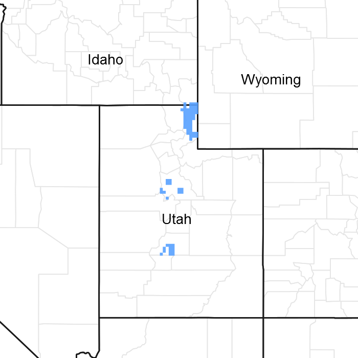
Figure 1. Mapped extent
Areas shown in blue indicate the maximum mapped extent of this ecological site. Other ecological sites likely occur within the highlighted areas. It is also possible for this ecological site to occur outside of highlighted areas if detailed soil survey has not been completed or recently updated.
MLRA notes
Major Land Resource Area (MLRA): 047X–Wasatch and Uinta Mountains
MLRA 47 occurs in Utah (86 percent), Wyoming (8 percent), Colorado (4 percent), and Idaho (2 percent). It encompasses approximately 23,825 square miles (61,740 square kilometers). The northern half of this area is in the Middle Rocky Mountains Province of the Rocky Mountain System. The southern half is in the High Plateaus of the Utah Section of the Colorado Plateaus Province of the Intermontane Plateaus. Parts of the western edge of this MLRA are in the Great Basin Section of the Basin and Range Province of the Intermontane Plateaus. The MLRA includes the Wasatch Mountains, which trend north and south, and the Uinta Mountains, which trend east and west. The steeply sloping, precipitous Wasatch Mountains have narrow crests and deep valleys. Active faulting and erosion are a dominant force in controlling the geomorphology of the area. The Uinta Mountains have a broad, gently arching, elongated shape. Structurally, they consist of a broadly folded anticline that has an erosion-resistant quartzite core. The Wasatch and Uinta Mountains have an elevation of 4,900 to about 13,500 feet (1,495 to 4,115 meters).
The mountains in this area are primarily fault blocks that have been tilted up. Alluvial fans at the base of the mountains are recharge zones for the basin fill aquifers. An ancient shoreline of historic Bonneville Lake is evident on the footslopes along the western edge of the area. Rocks exposed in the mountains are mostly Mesozoic and Paleozoic sediments, but Precambrian rocks are exposed in the Uinta Mountains. The Uinta Mountains are one of the few ranges in the United States that are oriented west to east. The southern Wasatch Mountains consist of Tertiary volcanic rocks occurring as extrusive lava and intrusive crystalline rocks.
The average precipitation is from 8 to 16 inches (203 to 406 mm) in the valleys and can range up to 73 inches (1854 mm) in the mountains. In the northern and western portions of the MLRA, peak precipitation occurs in the winter months. The southern and eastern portions have a greater incidence of high-intensity summer thunderstorms; hence, a significant amount of precipitation occurs during the summer months. The average annual temperature is 30 to 50 degrees Fahrenheit (-1 to 15 C). The freeze-free period averages 140 days and ranges from 60 to 220 days, generally decreasing in length with elevation.
The dominant soil orders in this MLRA are Aridisols, Entisols, Inceptisols, and Mollisols. The lower elevations are dominated by a frigid temperature regime, while the higher elevations experience cryic temperature regimes. Mesic temperature regimes come in on the lower elevations and south facing slopes in the southern portion of this MLRA. The soil moisture regime is typically xeric in the northern part of the MLRA, but grades to ustic in the extreme eastern and southern parts. The minerology is generally mixed and the soils are very shallow to very deep, generally well drained, and loamy or loamy-skeletal.
LRU notes
Major Land Resource Unit 47A is located in the northern half of the Middle Rocky Mountains Province of the Rocky Mountain System. This MLRA includes the Wasatch Mountains which tend to run north and south. These steeply sloping, precipitous mountains have narrow crests and deep valleys. They are primarily fault blocks that have been tilted up. The alluvial fans located at the base of these mountains are important recharge zones for valley aquifers.
Classification relationships
Modal Soil: Ellett SIL – loamy, mixed (calc.), frigid shallow, Xeric Torriorthents
Ecological site concept
This site represents areas on hillslopes, mountainsides and canyons. The plant community is Wyoming big sagebrush; bluebunch wheatgrass; Indian ricegrass; western wheatgrass; needle-and-thread grass; western mountain aster; Louisana sagewort; arrowleaf balsamroot and yellow rabbitbrush.
Associated sites
| R047XA305UT |
Upland Stony Loam (Utah juniper) This site is dominated by Utah juniper and, if adjacent to the Upland Stony Loam (Wyoming big sagebrush) site, may be a seed source for juniper invasion. |
|---|
Similar sites
| R047XA320UT |
Upland Shallow Loam (Wyoming big sagebrush) This site has soils that are less than 20 inches deep, resulting in reduced water-holding capacity. |
|---|---|
| R047XA334UT |
Upland Stony Loam (mountain big sagebrush) This site is dominated by Mountain big sagebrush instead of Wyomiing big sagebrush. |
Table 1. Dominant plant species
| Tree |
Not specified |
|---|---|
| Shrub |
(1) Artemisia tridentata ssp. wyomingensis |
| Herbaceous |
(1) Pseudoroegneria spicata |
Physiographic features
This site is most commonly found on foothills and mountainsides and canyons between 5500 and 8000 feet. It occurs less frequently on alluvial fans and escarpments. It can be found on all aspects with slopes ranging from 6 to 60 percent. This site has negligible to low runoff and is not subject to flooding or ponding.
Table 2. Representative physiographic features
| Landforms |
(1)
Hillslope
(2) Mountainside (3) Canyon |
|---|---|
| Runoff class | Negligible to low |
| Flooding frequency | None |
| Ponding frequency | None |
| Elevation | 5,500 – 8,000 ft |
| Slope | 6 – 60% |
| Ponding depth |
Not specified |
| Water table depth |
Not specified |
| Aspect | Aspect is not a significant factor |
Climatic features
The climate of this site is characterized by cold, snowy winters and cool dry summers. The frost-free and freeze-free periods may be extremely short in Rich County where this site is prevelant. Annual precipitation ranges from 12 to 16 inches with most of the moisture coming in the spring, winter and fall. Winter snowpack adds moisture to the soil as it melts in the spring. However, much of the spring moisture is unavailable to plants by mid-June, and reduced precipitation causes many herbaceous species to go dormant by July 1. June, July and August are the driest months of the year for this site.
Table 3. Representative climatic features
| Frost-free period (average) | 135 days |
|---|---|
| Freeze-free period (average) | 85 days |
| Precipitation total (average) | 15 in |
Figure 2. Monthly precipitation range
Figure 3. Monthly average minimum and maximum temperature
Figure 4. Annual precipitation pattern
Figure 5. Annual average temperature pattern
Influencing water features
Due to its landscape position, this site is not influenced by streams or wetlands.
Wetland description
N/A
Soil features
The soils of this site formed in colluvium and/or slope alluvium derived from sandstone and conglomerate mostly. They are moderately deep to deep, often with bedrock between 20 and 60 inches from the soil surface. The surface layer is usually 6 to 10 inches thick, loamy, and dark in color. Rock fragments are typically seen on the soil surface and noticeably increase with soil depth. These rock fragments make up at least 35 percent of the soil volume and may be gravel, cobble, or stone. The lower subsoil typically has over 50 percent rock fragments by volume. These soils are well drained. They can be calcareous or non-calcareous depending on the parent material. Permeability is moderate to moderately rapid. The water-holding capacity is 2 to 4.8 inches in the upper 40 inches of soil. The soil moisture regime is xeric and the soil temperature regime is frigid.
Table 4. Representative soil features
| Parent material |
(1)
Colluvium
–
sandstone
(2) Slope alluvium – conglomerate |
|---|---|
| Surface texture |
(1) Gravelly loam (2) Very gravelly loam (3) Loam (4) Gravelly silt loam |
| Family particle size |
(1) Loamy-skeletal |
| Drainage class | Well drained |
| Permeability class | Moderate to moderately rapid |
| Depth to restrictive layer | 20 – 60 in |
| Soil depth | 20 – 60 in |
| Surface fragment cover <=3" | 10 – 35% |
| Surface fragment cover >3" | 25% |
| Available water capacity (0-40in) |
2 – 4.8 in |
| Calcium carbonate equivalent (0-40in) |
20% |
| Electrical conductivity (0-40in) |
2 mmhos/cm |
| Sodium adsorption ratio (0-40in) |
5 |
| Soil reaction (1:1 water) (0-40in) |
6.6 – 9 |
| Subsurface fragment volume <=3" (Depth not specified) |
25 – 50% |
| Subsurface fragment volume >3" (Depth not specified) |
7 – 25% |
Ecological dynamics
The plant community dynamics of this site are presumed to have been driven by fire historically. The Reference Plant Community consists of very diverse shrubs, forbs and grasses. Wyoming big sagebrush would have co-dominated with bluebunch wheatgrass and other perennial bunchgrasses in the reference state, with grasses increasing in dominance following fire (or possibly other shrub-removing disturbance i.e. aroga moth, snow mold, etc.) and big sagebrush increasing in dominance over time without fire. When sprouting shrubs are abundant in the community, they tend to co-dominate with grasses on this site following fire.
The introduction of non-native plants and domestic livestock on this site since the time of European settlement has altered the plant community dynamics of this site, as diagrammed in the State-and-Transition Model. Although this site is resilient under properly managed livestock grazing, it is susceptible to grass loss and sagebrush dominance under excessive grazing pressures. When grazing pressures repeatedly remove the growing points (apical meristems) of perennial grasses, they tend to lose vigor and decrease on the site.
This site is expected to support introduced perennial grass species, when these species are seeded under the proper conditions for germination and establishment; however, seeded range has not yet been documented to occur on this site.
Extended periods without fire (decades to centuries) tends to result in increased Utah juniper on this site. Once established, Utah juniper will eventually dominate the plant community on this site if not removed by fire or other means. This increase in juniper results in a corresponding decrease in shrub and herbaceous production on this site.
Although cheatgrass and other non-native species have been documented on this site, there is no documentation of non-native annual species dominating the site. However, the conditions of this site are similar to many sagebrush sites where cheatgrass has become dominant, so care should be taken to increase the resilience of the site to cheatgrass invasion. Soil surface disturbance, removal of existing perennial plants, and introduction of cheatgrass seeds via hay, livestock, or vehicles will increase the likelihood of cheatgrass dominance on this site.
State and transition model

Figure 6. State-and-Transition Model
More interactive model formats are also available.
View Interactive Models
More interactive model formats are also available.
View Interactive Models
Click on state and transition labels to scroll to the respective text
Ecosystem states
| T1a | - | non-native species are introduced |
|---|---|---|
| T2a | - | Utah juniper becomes co-dominant - lack of fire |
State 1 submodel, plant communities
| 1.1a | - | fire or other shrub-removal disturbance |
|---|---|---|
| 1.1b | - | fire or other shrub-removal disturbance |
| 1.2a | - | Recovery time following fire or other shrub-removal events |
| 1.3a | - | Time following fire or other disturbances |
State 2 submodel, plant communities
| 2.1a | - | fire or other shrub-removal disturbance |
|---|---|---|
| 2.1b | - | fire or other shrub-removal disturbance |
| 2.1c | - | Utah juniper becomes established and slowly increases with time and lack of fire |
| 2.2a | - | Wyoming big sagebrush slowly increases in the plant community with time following fire or other shrub-removal events |
| 2.4a | - | fire or other shrub-removal disturbance |
State 3 submodel, plant communities
State 1
Reference State
The Reference State is a description of this ecological site just prior to Euro-American settlement but long after the arrival of Native Americans. The description of the Reference State was determined by NRCS Soil Survey Type Site Location information and familiarity with rangeland relict areas where they exist. The Reference State would have been characterized as a shrub steppe dominated by Wyoming big sagebrush (Artemisia tridentata ssp. wyomingensis) and having a rich native perennial herbaceous understory. The relative abundance of Wyoming big sagebrush and its perennial herbaceous understory on these sites would have depended on the amount of time elapsed since the last wildfire. Wildfire (1.1a) would have reduced Wyoming big sagebrush dominance, allowed for a temporary increase in disturbance-following shrubs when present (1.3), and allowed native perennial herbs to become temporarily dominant (1.1). In the absence of wildfire (1.2a), Wyoming big sagebrush would have become dominant, other shrubs would have become relatively less abundant, and the perennial herbaceous understory would have become relatively sparse (1.2).
Community 1.1
Wyoming big sagebrush / Perennial grass
The Reference Plant Community is dominated by Wyoming big sagebrush in the overstory, and by perennial bunchgrasses in the understory. Dominant perennial grasses are bluebunch wheatgrass, Indian ricegrass and needle and thread. Diverse shrubs, perennial grasses and forbs are also abundant in the community. Composition by air-dry weight is 25 to 50 percent grasses, 10 to 20 percent forbs, and 35 to 65 percent shrubs.
Figure 7. Annual production by plant type (representative values) or group (midpoint values)
Table 5. Annual production by plant type
| Plant type | Low (lb/acre) |
Representative value (lb/acre) |
High (lb/acre) |
|---|---|---|---|
| Shrub/Vine | 250 | 400 | 550 |
| Grass/Grasslike | 200 | 325 | 450 |
| Forb | 100 | 150 | 200 |
| Total | 550 | 875 | 1200 |
Table 6. Ground cover
| Tree foliar cover | 0% |
|---|---|
| Shrub/vine/liana foliar cover | 10-16% |
| Grass/grasslike foliar cover | 8-14% |
| Forb foliar cover | 4-8% |
| Non-vascular plants | 0% |
| Biological crusts | 0% |
| Litter | 5-15% |
| Surface fragments >0.25" and <=3" | 11-39% |
| Surface fragments >3" | 0-8% |
| Bedrock | 0% |
| Water | 0% |
| Bare ground | 25-35% |
Table 7. Canopy structure (% cover)
| Height Above Ground (ft) | Tree | Shrub/Vine | Grass/ Grasslike |
Forb |
|---|---|---|---|---|
| <0.5 | 0% | 0-2% | 0-2% | 0-5% |
| >0.5 <= 1 | 0% | 0-5% | 0-5% | 2-5% |
| >1 <= 2 | 0% | 2-10% | 5-15% | 2-5% |
| >2 <= 4.5 | 0% | 5-10% | 0-5% | 0-2% |
| >4.5 <= 13 | – | – | – | – |
| >13 <= 40 | – | – | – | – |
| >40 <= 80 | – | – | – | – |
| >80 <= 120 | – | – | – | – |
| >120 | – | – | – | – |
Community 1.2
Perennial grassland
The perennial grassland community is dominated by bluebunch wheatgrass and Indian ricegrass. Diverse perennial grasses and forbs are also abundant in the plant community. Sprouting shrubs may be present in small numbers, but are not abundant in this community phase. Wyoming big sagebrush has been removed from the plant community, but may also be present (not dominant) due to natural succession as it slowly increases in the community following removal. Composition by air-dry weight is 50 to 90 grasses grasses, 10 to 20 percent forbs, and 0 to 35 percent shrubs.
Figure 8. Annual production by plant type (representative values) or group (midpoint values)
Table 8. Annual production by plant type
| Plant type | Low (lb/acre) |
Representative value (lb/acre) |
High (lb/acre) |
|---|---|---|---|
| Grass/Grasslike | 400 | 550 | 700 |
| Shrub/Vine | 0 | 100 | 250 |
| Forb | 100 | 150 | 200 |
| Total | 500 | 800 | 1150 |
Table 9. Ground cover
| Tree foliar cover | 0% |
|---|---|
| Shrub/vine/liana foliar cover | 0-8% |
| Grass/grasslike foliar cover | 15-25% |
| Forb foliar cover | 4-8% |
| Non-vascular plants | 0% |
| Biological crusts | 0% |
| Litter | 5-15% |
| Surface fragments >0.25" and <=3" | 11-39% |
| Surface fragments >3" | 0-8% |
| Bedrock | 0% |
| Water | 0% |
| Bare ground | 25-35% |
Table 10. Canopy structure (% cover)
| Height Above Ground (ft) | Tree | Shrub/Vine | Grass/ Grasslike |
Forb |
|---|---|---|---|---|
| <0.5 | 0% | 0-2% | 0-2% | 0-5% |
| >0.5 <= 1 | 0% | 0-5% | 5-10% | 2-5% |
| >1 <= 2 | 0% | 0-8% | 10-20% | 2-5% |
| >2 <= 4.5 | 0% | 0% | 0-5% | 0-2% |
| >4.5 <= 13 | – | – | – | – |
| >13 <= 40 | – | – | – | – |
| >40 <= 80 | – | – | – | – |
| >80 <= 120 | – | – | – | – |
| >120 | – | – | – | – |
Community 1.3
Sprouting Shrub / Perennial grass
This plant community is dominated by sprouting shrubs in the overstory (usually yellow rabbitbrush) and by perennial bunchgrasses in the understory. In moist areas, such as northern exposures or higher elevations, other sprouting shrubs, such as bitterbrush or serviceberry, may co-dominate with grasses. Dominant perennial grasses are typically bluebunch wheatgrass and Indian ricegrass. Diverse perennial grasses and forbs are also abundant. Wyoming big sagebrush does not co-dominate the site, but it may be present due to natural succession as it slowly increases in the community. Composition by air-dry weight is 35 to 60 percent grasses, 10 to 20 percent forbs, and 25 to 50 percent shrubs.
Figure 9. Annual production by plant type (representative values) or group (midpoint values)
Table 11. Annual production by plant type
| Plant type | Low (lb/acre) |
Representative value (lb/acre) |
High (lb/acre) |
|---|---|---|---|
| Grass/Grasslike | 250 | 400 | 550 |
| Shrub/Vine | 150 | 250 | 350 |
| Forb | 100 | 150 | 200 |
| Total | 500 | 800 | 1100 |
Table 12. Ground cover
| Tree foliar cover | 0% |
|---|---|
| Shrub/vine/liana foliar cover | 8-14% |
| Grass/grasslike foliar cover | 10-16% |
| Forb foliar cover | 4-8% |
| Non-vascular plants | 0% |
| Biological crusts | 0% |
| Litter | 5-15% |
| Surface fragments >0.25" and <=3" | 11-39% |
| Surface fragments >3" | 0-8% |
| Bedrock | 0% |
| Water | 0% |
| Bare ground | 25-35% |
Table 13. Canopy structure (% cover)
| Height Above Ground (ft) | Tree | Shrub/Vine | Grass/ Grasslike |
Forb |
|---|---|---|---|---|
| <0.5 | 0% | 0-2% | 0-2% | 0-5% |
| >0.5 <= 1 | 0% | 0-5% | 0-5% | 2-5% |
| >1 <= 2 | 0% | 2-10% | 5-15% | 2-5% |
| >2 <= 4.5 | 0% | 0-5% | 0-5% | 0-2% |
| >4.5 <= 13 | – | – | – | – |
| >13 <= 40 | – | – | – | – |
| >40 <= 80 | – | – | – | – |
| >80 <= 120 | – | – | – | – |
| >120 | – | – | – | – |
Pathway 1.1a
Community 1.1 to 1.2
This pathway occurs as fire or other shrub-removal disturbance (drought, herbivory, etc.) removes Wyoming big sagebrush from the plant community. Historic fire regime is expected to have been patchy, mixed-severity fires that occurred ever 10 to 70 years (Howard 1999). This pathway occurs when phase 1.1 does not have a significant amount of sprouting shrubs in the community, and results in a community dominated by perennial bunchgrasses.
Pathway 1.1b
Community 1.1 to 1.3
This pathway occurs as fire or other shrub-removal disturbance (drought, herbivory, etc.) removes Wyoming big sagebrush from the plant community. Historic fire regime is expected to have been patchy, mixed-severity fires that occurred ever 10 to 70 years (Howard 1999). This pathway occurs when phase 1.1 has a significant amount of sprouting shrubs in the community, and results in a community co-dominated by perennial bunchgrasses and sprouting shrubs, most commonly yellow rabbitbrush.
Pathway 1.2a
Community 1.2 to 1.1
This pathway occurs as Wyoming big sagebrush slowly increases in the plant community following fire or other shrub-removal events. It may take 10 to 40 years for sagebrush to re-gain dominance in the community, depending on subsequent weather events and distance to sagebrush seed source. The resulting community is co-dominated by sagebrush and perennial bunchgrasses.
Pathway 1.3a
Community 1.3 to 1.1
This pathway occurs as Wyoming big sagebrush slowly increases in the plant community, while sprouting shrubs decrease. It may take 10 to 40 years for sagebrush to regain dominance in the community following fire or other sagebrush-removal event, depending on subsequent weather and distance to sagebrush seed source. The resulting community is co-dominated by sagebrush and perennial bunchgrasses, with abundant sprouting shrubs remaining in the community.
State 2
Invaded State
The Invaded State is similar to the reference state in plant community structure and function, but it allows for the presence of some non-native invasive species. The lengthening of fire-return intervals since the time of European settlement also allows a new community phase in this state, which is characterized by the establishment and growth of Utah juniper, with minimal reductions in native woody and herbaceous species.
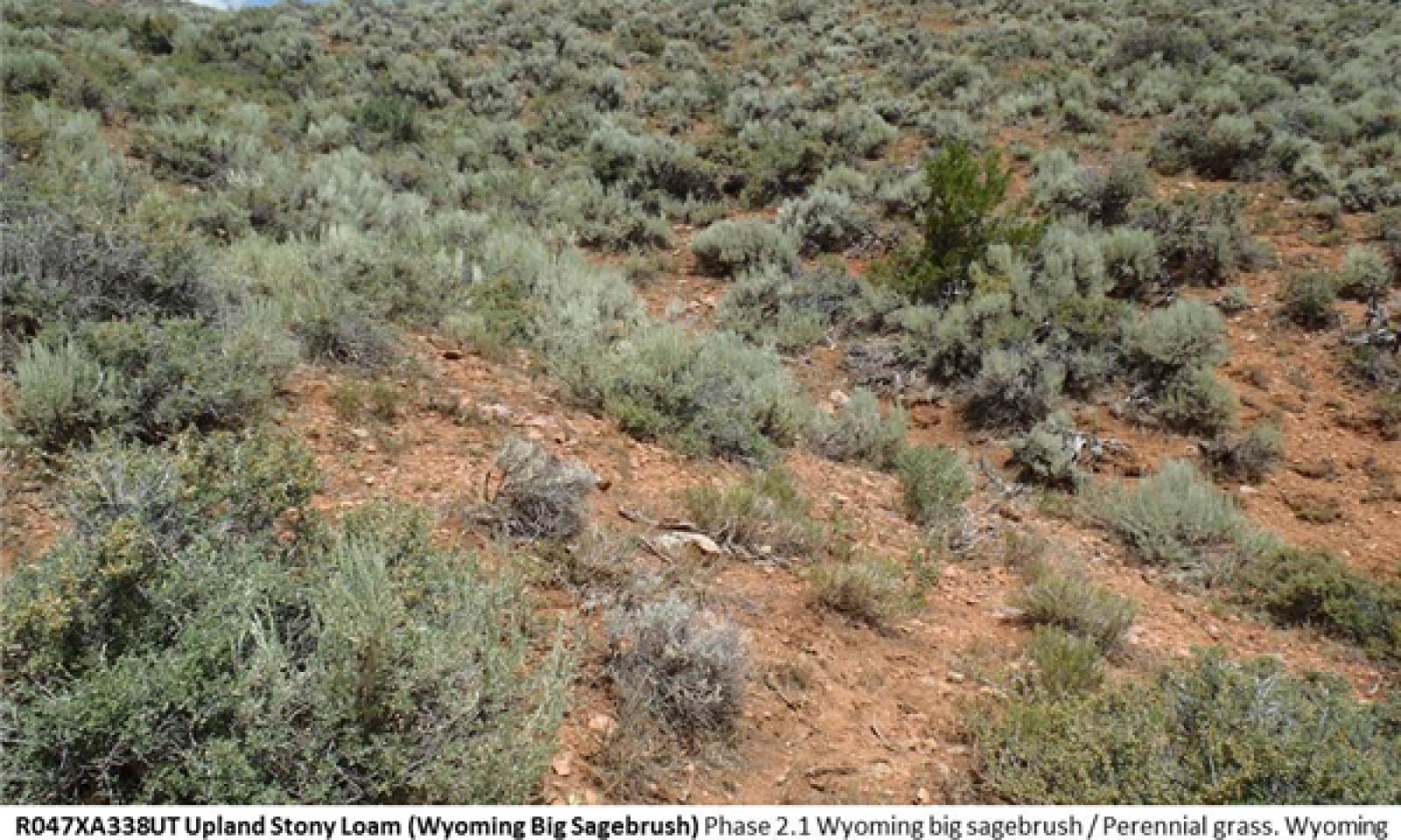
Community 2.1
Wyoming big sagebrush / Perennial grass

Figure 10. Phase 2.1
This plant community is dominated by Wyoming big sagebrush in the overstory, and by perennial bunchgrasses in the understory. Dominant perennial grasses are bluebunch wheatgrass, Indian ricegrass and needle and thread. Diverse shrubs, perennial grasses and forbs are also abundant in the community. Non-native species are present but not dominant. Composition by air-dry weight is 20 to 50 percent grasses, 10 to 20 percent forbs, and 35 to 70 percent shrubs.
Figure 11. Annual production by plant type (representative values) or group (midpoint values)
Table 14. Annual production by plant type
| Plant type | Low (lb/acre) |
Representative value (lb/acre) |
High (lb/acre) |
|---|---|---|---|
| Shrub/Vine | 250 | 400 | 550 |
| Grass/Grasslike | 200 | 325 | 450 |
| Forb | 100 | 150 | 200 |
| Total | 550 | 875 | 1200 |
Table 15. Ground cover
| Tree foliar cover | 0% |
|---|---|
| Shrub/vine/liana foliar cover | 10-16% |
| Grass/grasslike foliar cover | 8-14% |
| Forb foliar cover | 4-8% |
| Non-vascular plants | 0% |
| Biological crusts | 0% |
| Litter | 5-15% |
| Surface fragments >0.25" and <=3" | 11-39% |
| Surface fragments >3" | 0-8% |
| Bedrock | 0% |
| Water | 0% |
| Bare ground | 25-35% |
Table 16. Canopy structure (% cover)
| Height Above Ground (ft) | Tree | Shrub/Vine | Grass/ Grasslike |
Forb |
|---|---|---|---|---|
| <0.5 | 0% | 0-2% | 0-2% | 0-5% |
| >0.5 <= 1 | 0% | 0-5% | 0-5% | 2-5% |
| >1 <= 2 | 0% | 2-10% | 5-15% | 2-5% |
| >2 <= 4.5 | 0% | 5-10% | 0-5% | 0-2% |
| >4.5 <= 13 | – | – | – | – |
| >13 <= 40 | – | – | – | – |
| >40 <= 80 | – | – | – | – |
| >80 <= 120 | – | – | – | – |
| >120 | – | – | – | – |
Community 2.2
Perennial grassland
The perennial grassland community is dominated by bluebunch wheatgrass and Indian ricegrass. Diverse perennial grasses and forbs are also abundant in the plant community. Sprouting shrubs may be present in small numbers, but are not abundant in this community phase. Wyoming big sagebrush has been removed from the plant community, but may also be present (not dominant) due to natural succession as it slowly increases in the community following removal. Composition by air-dry weight is 50 to 90 percent grasses, 10 to 20 percent forbs, and 0 to 35 percent shrubs.
Figure 12. Annual production by plant type (representative values) or group (midpoint values)
Table 17. Annual production by plant type
| Plant type | Low (lb/acre) |
Representative value (lb/acre) |
High (lb/acre) |
|---|---|---|---|
| Grass/Grasslike | 400 | 550 | 700 |
| Shrub/Vine | 0 | 100 | 250 |
| Forb | 100 | 150 | 200 |
| Total | 500 | 800 | 1150 |
Table 18. Ground cover
| Tree foliar cover | 0% |
|---|---|
| Shrub/vine/liana foliar cover | 0-8% |
| Grass/grasslike foliar cover | 15-25% |
| Forb foliar cover | 4-8% |
| Non-vascular plants | 0% |
| Biological crusts | 0% |
| Litter | 5-15% |
| Surface fragments >0.25" and <=3" | 11-39% |
| Surface fragments >3" | 0-8% |
| Bedrock | 0% |
| Water | 0% |
| Bare ground | 25-35% |
Table 19. Canopy structure (% cover)
| Height Above Ground (ft) | Tree | Shrub/Vine | Grass/ Grasslike |
Forb |
|---|---|---|---|---|
| <0.5 | 0% | 0-2% | 0-2% | 0-5% |
| >0.5 <= 1 | 0% | 0-5% | 5-10% | 2-5% |
| >1 <= 2 | 0% | 0-8% | 10-20% | 2-5% |
| >2 <= 4.5 | 0% | 0% | 0-5% | 0-2% |
| >4.5 <= 13 | – | – | – | – |
| >13 <= 40 | – | – | – | – |
| >40 <= 80 | – | – | – | – |
| >80 <= 120 | – | – | – | – |
| >120 | – | – | – | – |
Community 2.3
Sprouting Shrub / Perennial grass
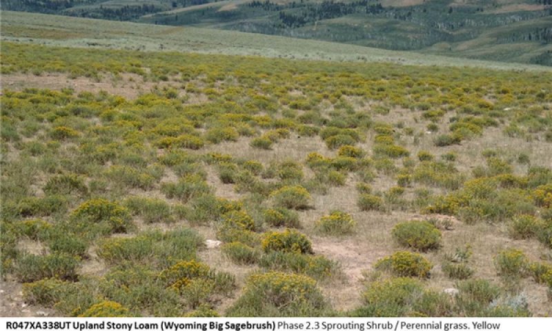
Figure 13. Phase 2.3
This plant community is dominated by sprouting shrubs in the overstory (usually yellow rabbitbrush) and by perennial bunchgrasses in the understory. In moist areas, such as northern exposures or higher elevations, other sprouting shrubs, such as bitterbrush or serviceberry, may co-dominate with grasses. Dominant perennial grasses are typically bluebunch wheatgrass and Indian ricegrass. Diverse perennial grasses and forbs are also abundant. Wyoming big sagebrush does not co-dominate the site, but it may be present due to natural succession as it slowly increases in the community. Composition by air-dry weight is 35 to 60 percent grasses, 10 to 20 percent forbs, and 25 to 50 percent shrubs.
Figure 14. Annual production by plant type (representative values) or group (midpoint values)
Table 20. Annual production by plant type
| Plant type | Low (lb/acre) |
Representative value (lb/acre) |
High (lb/acre) |
|---|---|---|---|
| Grass/Grasslike | 250 | 400 | 550 |
| Shrub/Vine | 150 | 250 | 350 |
| Forb | 100 | 150 | 200 |
| Total | 500 | 800 | 1100 |
Table 21. Ground cover
| Tree foliar cover | 0% |
|---|---|
| Shrub/vine/liana foliar cover | 8-14% |
| Grass/grasslike foliar cover | 10-16% |
| Forb foliar cover | 4-8% |
| Non-vascular plants | 0% |
| Biological crusts | 0% |
| Litter | 5-15% |
| Surface fragments >0.25" and <=3" | 11-39% |
| Surface fragments >3" | 0-8% |
| Bedrock | 0% |
| Water | 0% |
| Bare ground | 25-35% |
Table 22. Canopy structure (% cover)
| Height Above Ground (ft) | Tree | Shrub/Vine | Grass/ Grasslike |
Forb |
|---|---|---|---|---|
| <0.5 | 0% | 0-2% | 0-2% | 0-5% |
| >0.5 <= 1 | 0% | 0-5% | 0-5% | 2-5% |
| >1 <= 2 | 0% | 2-10% | 5-15% | 2-5% |
| >2 <= 4.5 | 0% | 0-5% | 0-5% | 0-2% |
| >4.5 <= 13 | – | – | – | – |
| >13 <= 40 | – | – | – | – |
| >40 <= 80 | – | – | – | – |
| >80 <= 120 | – | – | – | – |
| >120 | – | – | – | – |
Community 2.4
Sagebrush Grassland with Juniper
Figure 15. Phase 2.4
This plant community is dominated by Wyoming big sagebrush and perennial bunchgrasses, but with Utah juniper increasing significantly in the community. However, junipers are mostly small shrubs of a single age class. Bluebunch wheatgrass, Indian ricegrass and needle and thread remain the dominant grasses. Diverse shrubs, perennial grasses and forbs are still abundant in the community. Non-native species are present but not dominant. Composition by air-dry weight is 20 to 50 percent grasses, 10 to 20 percent forbs, 30 to 55 percent shrubs, and 5 to 35 percent Utah juniper.
Figure 16. Annual production by plant type (representative values) or group (midpoint values)
Table 23. Annual production by plant type
| Plant type | Low (lb/acre) |
Representative value (lb/acre) |
High (lb/acre) |
|---|---|---|---|
| Shrub/Vine | 250 | 400 | 550 |
| Grass/Grasslike | 200 | 325 | 450 |
| Forb | 100 | 150 | 200 |
| Total | 550 | 875 | 1200 |
Table 24. Ground cover
| Tree foliar cover | 0% |
|---|---|
| Shrub/vine/liana foliar cover | 10-16% |
| Grass/grasslike foliar cover | 8-14% |
| Forb foliar cover | 4-8% |
| Non-vascular plants | 0% |
| Biological crusts | 0% |
| Litter | 5-15% |
| Surface fragments >0.25" and <=3" | 11-39% |
| Surface fragments >3" | 0-8% |
| Bedrock | 0% |
| Water | 0% |
| Bare ground | 25-35% |
Table 25. Canopy structure (% cover)
| Height Above Ground (ft) | Tree | Shrub/Vine | Grass/ Grasslike |
Forb |
|---|---|---|---|---|
| <0.5 | 0% | 0-2% | 0-2% | 0-5% |
| >0.5 <= 1 | 0% | 0-5% | 0-5% | 2-5% |
| >1 <= 2 | 0% | 2-10% | 5-15% | 2-5% |
| >2 <= 4.5 | 0% | 5-10% | 0-5% | 0-2% |
| >4.5 <= 13 | – | – | – | – |
| >13 <= 40 | – | – | – | – |
| >40 <= 80 | – | – | – | – |
| >80 <= 120 | – | – | – | – |
| >120 | – | – | – | – |
Pathway 2.1a
Community 2.1 to 2.2
This pathway occurs as fire or other shrub-removal disturbance (drought, herbivory, etc.) removes Wyoming big sagebrush from the plant community. Historic fire regime is expected to have been patchy, mixed-severity fires that occurred ever 10 to 70 years (Howard 1999). This pathway occurs when phase 2.1 does not have a significant amount of sprouting shrubs in the community, and results in a community dominated by perennial bunchgrasses. This pathway may result in an increase in annual non-native species.
Pathway 2.1b
Community 2.1 to 2.3
This pathway occurs as fire or other shrub-removal disturbance (drought, herbivory, etc.) removes Wyoming big sagebrush from the plant community. Historic fire regime is expected to have been patchy, mixed-severity fires that occurred ever 10 to 70 years (Howard 1999). This pathway occurs when phase 2.1 has a significant amount of sprouting shrubs in the community, and results in a community co-dominated by perennial bunchgrasses and sprouting shrubs, most commonly yellow rabbitbrush. This pathway may result in an increase in annual non-native species.
Pathway 2.1c
Community 2.1 to 2.4
This pathway occurs as Utah juniper becomes established and slowly increases in the plant community. It may take decades to centuries following fire for Utah juniper to become a major part of the community, depending on weather events and juniper seed dispersal. Native shrubs and grasses continue to dominate the site even during this community phase pathway.
Pathway 2.2a
Community 2.2 to 2.1
This pathway occurs as Wyoming big sagebrush slowly increases in the plant community following fire or other shrub-removal events. It may take 10-40 years for sagebrush to re-gain dominance in the community, depending on subsequent weather events and distance to sagebrush seed source. The resulting community is co-dominated by sagebrush and perennial bunchgrasses.
Pathway 2.3a
Community 2.3 to 2.1
This pathway occurs as Wyoming big sagebrush slowly increases in the plant community, while sprouting shrubs decrease. It may take 10 to 40 years for sagebrush to regain dominance in the community following fire or other sagebrush-removal event, depending on subsequent weather and distance to sagebrush seed source. The resulting community is co-dominated by sagebrush and perennial bunchgrasses, with abundant sprouting shrubs remaining in the community.
Context dependence. Wyoming big sagebrush slowly increases in the plant community, while sprouting shrubs decrease with time following fire
Pathway 2.4a
Community 2.4 to 2.1
This pathway occurs as fire or other shrub-removal disturbance (drought, herbivory, etc.) removes Wyoming big sagebrush and Utah juniper from the plant community. Historic fire regime is expected to have been patchy, mixed-severity fires that occurred ever 10-70 years (Howard 1999). This pathway occurs when phase 2.4 does not have a significant amount of sprouting shrubs in the community, and results in a community dominated by perennial bunchgrasses. This pathway may result in an increase in annual non-native species.
Pathway 2.4b
Community 2.4 to 2.3
This pathway occurs as fire or other shrub-removal disturbance (drought, herbivory, etc.) removes Wyoming big sagebrush and Utah juniper from the plant community. Historic fire regime is expected to have been patchy, mixed-severity fires that occurred every 10-70 years (Howard 1999). This pathway occurs when phase 2.4 has a significant amount of sprouting shrubs in the community, and results in a community co-dominated by perennial bunchgrasses and sprouting shrubs, most commonly yellow rabbitbrush. This pathway may result in an increase in annual non-native species.
State 3
Juniper State
This state is characterized by Utah juniper dominance of both ecological function and community structure. Juniper may continue to increase in this state until very few of the dominant reference species remain. This state may not be subject to extreme erosion due to the rockiness of the soil, but large bare patches may be subject to some localized accelerated erosion. Removal of juniper will require seeding of some species given the absence of seed production by native grasses and shrubs in this state.
Community 3.1
Wyoming big sagebrush / Perennial grass
Figure 17. Phase 3.1
This plant community is dominated by Wyoming big sagebrush in the overstory, and by perennial bunchgrasses in the understory. Dominant perennial grasses are bluebunch wheatgrass, Indian ricegrass and needle and thread. Diverse shrubs, perennial grasses and forbs are also abundant in the community. Non-native species are present but not dominant. Composition by air-dry weight is 20 to 50 percent grasses, 10 to 20 percent forbs, and 35 to 70 percent shrubs.
Figure 18. Annual production by plant type (representative values) or group (midpoint values)
Table 26. Annual production by plant type
| Plant type | Low (lb/acre) |
Representative value (lb/acre) |
High (lb/acre) |
|---|---|---|---|
| Tree | 250 | 400 | 600 |
| Shrub/Vine | 50 | 150 | 250 |
| Grass/Grasslike | 50 | 150 | 250 |
| Forb | 25 | 150 | 200 |
| Total | 375 | 850 | 1300 |
Table 27. Ground cover
| Tree foliar cover | 10-25% |
|---|---|
| Shrub/vine/liana foliar cover | 0-10% |
| Grass/grasslike foliar cover | 0-5% |
| Forb foliar cover | 0-5% |
| Non-vascular plants | 0% |
| Biological crusts | 0% |
| Litter | 5-15% |
| Surface fragments >0.25" and <=3" | 11-39% |
| Surface fragments >3" | 0-8% |
| Bedrock | 0% |
| Water | 0% |
| Bare ground | 35-45% |
Table 28. Canopy structure (% cover)
| Height Above Ground (ft) | Tree | Shrub/Vine | Grass/ Grasslike |
Forb |
|---|---|---|---|---|
| <0.5 | 0% | 0-2% | 0-2% | 0-2% |
| >0.5 <= 1 | 0% | 0-5% | 0-2% | 0-5% |
| >1 <= 2 | 0% | 0-10% | 0-5% | 0-5% |
| >2 <= 4.5 | 0-10% | 0-10% | 0-2% | 0-2% |
| >4.5 <= 13 | 10-25% | – | – | – |
| >13 <= 40 | 0-5% | – | – | – |
| >40 <= 80 | – | – | – | – |
| >80 <= 120 | – | – | – | – |
| >120 | – | – | – | – |
Transition T1a
State 1 to 2
This transition occurs as non-native species are introduced to the site. The invaded state is similar to the reference state in plant community structure and ecological process, but the presence of domestic livestock and exotic plants decreases the resilience of the site.
Transition T2a
State 2 to 3
This transition occurs when Utah juniper becomes co-dominant in the plant community. Indicators are decreased perennial grasses and shrubs, increased bare ground, and multiple age classes of Utah juniper (indicating repeated recruitment events on the site). It is unclear at which point state 2 crosses an irreversible threshold into state 3, but the inability of the site to carry a fire, or the lack of perennial grass and shrub seed/propagules following a wildfire are useful qualitative indicators.
Additional community tables
Table 29. Community 1.1 plant community composition
| Group | Common name | Symbol | Scientific name | Annual production (lb/acre) | Foliar cover (%) | |
|---|---|---|---|---|---|---|
|
Shrub/Vine
|
||||||
| 1 | Dominant shrubs | 200–400 | ||||
| Wyoming big sagebrush | ARTRW8 | Artemisia tridentata ssp. wyomingensis | 200–400 | 8–16 | ||
| 3 | Sub-Dominant Shrubs | 75–150 | ||||
| antelope bitterbrush | PUTR2 | Purshia tridentata | 0–125 | 0–5 | ||
| Saskatoon serviceberry | AMAL2 | Amelanchier alnifolia | 0–100 | 0–4 | ||
| yellow rabbitbrush | CHVIV4 | Chrysothamnus viscidiflorus ssp. viscidiflorus var. viscidiflorus | 10–100 | 0–4 | ||
| broom snakeweed | GUSA2 | Gutierrezia sarothrae | 0–30 | 0–1 | ||
| black sagebrush | ARNO4 | Artemisia nova | 0–30 | 0–1 | ||
| mountain snowberry | SYOR2 | Symphoricarpos oreophilus | 0–30 | 0–1 | ||
| spineless horsebrush | TECA2 | Tetradymia canescens | 0–30 | 0–1 | ||
| spiny phlox | PHHO | Phlox hoodii | 0–30 | 0–1 | ||
| Shrub (>.5m) | 2SHRUB | Shrub (>.5m) | 10–29 | – | ||
| creeping barberry | MARE11 | Mahonia repens | 0–25 | 0–1 | ||
| shadscale saltbush | ATCO | Atriplex confertifolia | 0–20 | 0–1 | ||
| alderleaf mountain mahogany | CEMO2 | Cercocarpus montanus | 0–20 | 0–1 | ||
| slender buckwheat | ERMI4 | Eriogonum microthecum | 0–10 | 0–1 | ||
| rubber rabbitbrush | ERNA10 | Ericameria nauseosa | 0–10 | 0–1 | ||
|
Grass/Grasslike
|
||||||
| 2 | Dominant Grasses | 150–400 | ||||
| bluebunch wheatgrass | PSSP6 | Pseudoroegneria spicata | 100–300 | 4–12 | ||
| Indian ricegrass | ACHY | Achnatherum hymenoides | 50–150 | 2–7 | ||
| needle and thread | HECO26 | Hesperostipa comata | 25–75 | 1–3 | ||
| 1 | Sub-dominant grasses | 25–150 | ||||
| Letterman's needlegrass | ACLE9 | Achnatherum lettermanii | 0–75 | 0–3 | ||
| western wheatgrass | PASM | Pascopyrum smithii | 0–75 | 0–3 | ||
| squirreltail | ELEL5 | Elymus elymoides | 0–50 | 0–2 | ||
| Grass, perennial | 2GP | Grass, perennial | 0–50 | 0–2 | ||
| oniongrass | MEBU | Melica bulbosa | 0–50 | 0–2 | ||
| Idaho fescue | FEID | Festuca idahoensis | 0–25 | 0–1 | ||
| basin wildrye | LECI4 | Leymus cinereus | 0–25 | 0–1 | ||
| muttongrass | POFE | Poa fendleriana | 0–25 | 0–1 | ||
| Geyer's sedge | CAGE2 | Carex geyeri | 0–25 | 0–1 | ||
| Grass, annual | 2GA | Grass, annual | 0–25 | 0–1 | ||
|
Forb
|
||||||
| 2 | Forbs | 100–200 | ||||
| sulphur-flower buckwheat | ERUM | Eriogonum umbellatum | 0–50 | 0–2 | ||
| Forb, perennial | 2FP | Forb, perennial | 10–50 | 0–2 | ||
| arrowleaf balsamroot | BASA3 | Balsamorhiza sagittata | 0–50 | 0–2 | ||
| Forb, annual | 2FA | Forb, annual | 5–40 | 0–2 | ||
| tailcup lupine | LUCAC3 | Lupinus caudatus ssp. caudatus | 0–40 | 0–2 | ||
| shortstem buckwheat | ERBR5 | Eriogonum brevicaule | 0–30 | 0–1 | ||
| Eaton's fleabane | EREA | Erigeron eatonii | 0–20 | 0–1 | ||
| tapertip hawksbeard | CRAC2 | Crepis acuminata | 0–20 | 0–1 | ||
| tufted evening primrose | OECA10 | Oenothera caespitosa | 0–20 | 0–1 | ||
| lobeleaf groundsel | PAMU11 | Packera multilobata | 0–20 | 0–1 | ||
| low beardtongue | PEHU | Penstemon humilis | 0–20 | 0–1 | ||
| longleaf phlox | PHLO2 | Phlox longifolia | 0–20 | 0–1 | ||
| mustard | BRASS2 | Brassica | 0–20 | 0–1 | ||
| sego lily | CANU3 | Calochortus nuttallii | 0–20 | 0–1 | ||
| common yarrow | ACMI2 | Achillea millefolium | 0–20 | 0–1 | ||
| pussytoes | ANTEN | Antennaria | 0–20 | 0–1 | ||
| white sagebrush | ARLU | Artemisia ludoviciana | 0–20 | 0–1 | ||
| silverleaf milkvetch | ASAR4 | Astragalus argophyllus | 0–20 | 0–1 | ||
| scarlet gilia | IPAG | Ipomopsis aggregata | 0–20 | 0–1 | ||
| Bonneville pea | LABR | Lathyrus brachycalyx | 0–20 | 0–1 | ||
| maiden blue eyed Mary | COPA3 | Collinsia parviflora | 0–10 | 0–1 | ||
Table 30. Community 1.2 plant community composition
| Group | Common name | Symbol | Scientific name | Annual production (lb/acre) | Foliar cover (%) | |
|---|---|---|---|---|---|---|
|
Grass/Grasslike
|
||||||
| 0 | Dominant Grasses | 350–600 | ||||
| 1 | Sub-dominant grasses | 50–200 | ||||
| Letterman's needlegrass | ACLE9 | Achnatherum lettermanii | 0–125 | 0–5 | ||
| western wheatgrass | PASM | Pascopyrum smithii | 0–75 | 0–3 | ||
| squirreltail | ELEL5 | Elymus elymoides | 0–50 | 0–2 | ||
| Grass, perennial | 2GP | Grass, perennial | 0–50 | 0–2 | ||
| oniongrass | MEBU | Melica bulbosa | 0–50 | 0–2 | ||
| Idaho fescue | FEID | Festuca idahoensis | 0–25 | 0–1 | ||
| basin wildrye | LECI4 | Leymus cinereus | 0–25 | 0–1 | ||
| muttongrass | POFE | Poa fendleriana | 0–25 | 0–1 | ||
| Geyer's sedge | CAGE2 | Carex geyeri | 0–25 | 0–1 | ||
| Grass, annual | 2GA | Grass, annual | 0–25 | 0–1 | ||
|
Forb
|
||||||
| 2 | Forbs | 100–200 | ||||
| sulphur-flower buckwheat | ERUM | Eriogonum umbellatum | 0–50 | 0–2 | ||
| Forb, perennial | 2FP | Forb, perennial | 10–50 | 0–2 | ||
| arrowleaf balsamroot | BASA3 | Balsamorhiza sagittata | 0–50 | 0–2 | ||
| Forb, annual | 2FA | Forb, annual | 5–40 | 0–2 | ||
| tailcup lupine | LUCAC3 | Lupinus caudatus ssp. caudatus | 0–40 | 0–2 | ||
| shortstem buckwheat | ERBR5 | Eriogonum brevicaule | 0–30 | 0–1 | ||
| Eaton's fleabane | EREA | Erigeron eatonii | 0–20 | 0–1 | ||
| tapertip hawksbeard | CRAC2 | Crepis acuminata | 0–20 | 0–1 | ||
| tufted evening primrose | OECA10 | Oenothera caespitosa | 0–20 | 0–1 | ||
| lobeleaf groundsel | PAMU11 | Packera multilobata | 0–20 | 0–1 | ||
| low beardtongue | PEHU | Penstemon humilis | 0–20 | 0–1 | ||
| longleaf phlox | PHLO2 | Phlox longifolia | 0–20 | 0–1 | ||
| mustard | BRASS2 | Brassica | 0–20 | 0–1 | ||
| sego lily | CANU3 | Calochortus nuttallii | 0–20 | 0–1 | ||
| common yarrow | ACMI2 | Achillea millefolium | 0–20 | 0–1 | ||
| pussytoes | ANTEN | Antennaria | 0–20 | 0–1 | ||
| white sagebrush | ARLU | Artemisia ludoviciana | 0–20 | 0–1 | ||
| silverleaf milkvetch | ASAR4 | Astragalus argophyllus | 0–20 | 0–1 | ||
| scarlet gilia | IPAG | Ipomopsis aggregata | 0–20 | 0–1 | ||
| Bonneville pea | LABR | Lathyrus brachycalyx | 0–20 | 0–1 | ||
| maiden blue eyed Mary | COPA3 | Collinsia parviflora | 0–10 | 0–1 | ||
|
Shrub/Vine
|
||||||
| 3 | Shrubs | 0–250 | ||||
| yellow rabbitbrush | CHVIV4 | Chrysothamnus viscidiflorus ssp. viscidiflorus var. viscidiflorus | 10–50 | 0–2 | ||
| antelope bitterbrush | PUTR2 | Purshia tridentata | 0–50 | 0–2 | ||
| Saskatoon serviceberry | AMAL2 | Amelanchier alnifolia | 0–50 | 0–2 | ||
| black sagebrush | ARNO4 | Artemisia nova | 0–30 | 0–1 | ||
| mountain snowberry | SYOR2 | Symphoricarpos oreophilus | 0–30 | 0–1 | ||
| spineless horsebrush | TECA2 | Tetradymia canescens | 0–30 | 0–1 | ||
| broom snakeweed | GUSA2 | Gutierrezia sarothrae | 0–30 | 0–1 | ||
| spiny phlox | PHHO | Phlox hoodii | 0–30 | 0–1 | ||
| Shrub (>.5m) | 2SHRUB | Shrub (>.5m) | 10–29 | – | ||
| creeping barberry | MARE11 | Mahonia repens | 0–25 | 0–1 | ||
| shadscale saltbush | ATCO | Atriplex confertifolia | 0–20 | 0–1 | ||
| alderleaf mountain mahogany | CEMO2 | Cercocarpus montanus | 0–20 | 0–1 | ||
| slender buckwheat | ERMI4 | Eriogonum microthecum | 0–10 | 0–1 | ||
| rubber rabbitbrush | ERNA10 | Ericameria nauseosa | 0–10 | 0–1 | ||
Table 31. Community 1.3 plant community composition
| Group | Common name | Symbol | Scientific name | Annual production (lb/acre) | Foliar cover (%) | |
|---|---|---|---|---|---|---|
|
Shrub/Vine
|
||||||
| 1 | Dominant Shrubs | 125–300 | ||||
| yellow rabbitbrush | CHVI8 | Chrysothamnus viscidiflorus | 50–250 | 2–10 | ||
| antelope bitterbrush | PUTR2 | Purshia tridentata | 0–200 | 0–8 | ||
| Utah serviceberry | AMUT | Amelanchier utahensis | 0–200 | 0–8 | ||
| 3 | Sub-dominant Shrubs | 25–225 | ||||
| broom snakeweed | GUSA2 | Gutierrezia sarothrae | 0–50 | 0–2 | ||
| spiny phlox | PHHO | Phlox hoodii | 0–30 | 0–1 | ||
| mountain snowberry | SYOR2 | Symphoricarpos oreophilus | 0–30 | 0–1 | ||
| spineless horsebrush | TECA2 | Tetradymia canescens | 0–30 | 0–1 | ||
| Shrub (>.5m) | 2SHRUB | Shrub (>.5m) | 0–30 | 0–1 | ||
| black sagebrush | ARNO4 | Artemisia nova | 0–30 | 0–1 | ||
| creeping barberry | MARE11 | Mahonia repens | 0–25 | 0–1 | ||
| shadscale saltbush | ATCO | Atriplex confertifolia | 0–20 | 0–1 | ||
| alderleaf mountain mahogany | CEMO2 | Cercocarpus montanus | 0–20 | 0–1 | ||
| slender buckwheat | ERMI4 | Eriogonum microthecum | 0–10 | 0–1 | ||
| rubber rabbitbrush | ERNA10 | Ericameria nauseosa | 0–10 | 0–1 | ||
|
Grass/Grasslike
|
||||||
| 2 | Dominant Grasses | 225–500 | ||||
| bluebunch wheatgrass | PSSP6 | Pseudoroegneria spicata | 150–350 | 6–14 | ||
| Indian ricegrass | ACHY | Achnatherum hymenoides | 50–200 | 2–8 | ||
| needle and thread | HECO26 | Hesperostipa comata | 50–150 | 2–6 | ||
| 1 | Sub-dominant grasses | 25–150 | ||||
| Letterman's needlegrass | ACLE9 | Achnatherum lettermanii | 0–125 | 0–5 | ||
| western wheatgrass | PASM | Pascopyrum smithii | 0–75 | 0–3 | ||
| squirreltail | ELEL5 | Elymus elymoides | 0–50 | 0–2 | ||
| Grass, perennial | 2GP | Grass, perennial | 0–50 | 0–2 | ||
| oniongrass | MEBU | Melica bulbosa | 0–50 | 0–2 | ||
| Idaho fescue | FEID | Festuca idahoensis | 0–25 | 0–1 | ||
| basin wildrye | LECI4 | Leymus cinereus | 0–25 | 0–1 | ||
| Geyer's sedge | CAGE2 | Carex geyeri | 0–25 | 0–1 | ||
| Grass, annual | 2GA | Grass, annual | 0–25 | 0–1 | ||
| muttongrass | POFE | Poa fendleriana | 0–25 | 0–1 | ||
|
Forb
|
||||||
| 2 | Forbs | 100–200 | ||||
| sulphur-flower buckwheat | ERUM | Eriogonum umbellatum | 0–50 | 0–2 | ||
| Forb, perennial | 2FP | Forb, perennial | 10–50 | 0–2 | ||
| arrowleaf balsamroot | BASA3 | Balsamorhiza sagittata | 0–50 | 0–2 | ||
| Forb, annual | 2FA | Forb, annual | 5–40 | 0–2 | ||
| tailcup lupine | LUCAC3 | Lupinus caudatus ssp. caudatus | 0–40 | 0–2 | ||
| shortstem buckwheat | ERBR5 | Eriogonum brevicaule | 0–30 | 0–1 | ||
| Eaton's fleabane | EREA | Erigeron eatonii | 0–20 | 0–1 | ||
| tapertip hawksbeard | CRAC2 | Crepis acuminata | 0–20 | 0–1 | ||
| tufted evening primrose | OECA10 | Oenothera caespitosa | 0–20 | 0–1 | ||
| lobeleaf groundsel | PAMU11 | Packera multilobata | 0–20 | 0–1 | ||
| low beardtongue | PEHU | Penstemon humilis | 0–20 | 0–1 | ||
| longleaf phlox | PHLO2 | Phlox longifolia | 0–20 | 0–1 | ||
| mustard | BRASS2 | Brassica | 0–20 | 0–1 | ||
| sego lily | CANU3 | Calochortus nuttallii | 0–20 | 0–1 | ||
| common yarrow | ACMI2 | Achillea millefolium | 0–20 | 0–1 | ||
| pussytoes | ANTEN | Antennaria | 0–20 | 0–1 | ||
| white sagebrush | ARLU | Artemisia ludoviciana | 0–20 | 0–1 | ||
| silverleaf milkvetch | ASAR4 | Astragalus argophyllus | 0–20 | 0–1 | ||
| scarlet gilia | IPAG | Ipomopsis aggregata | 0–20 | 0–1 | ||
| Bonneville pea | LABR | Lathyrus brachycalyx | 0–20 | 0–1 | ||
| maiden blue eyed Mary | COPA3 | Collinsia parviflora | 0–10 | 0–1 | ||
Table 32. Community 2.1 plant community composition
| Group | Common name | Symbol | Scientific name | Annual production (lb/acre) | Foliar cover (%) | |
|---|---|---|---|---|---|---|
|
Shrub/Vine
|
||||||
| 1 | Dominant shrubs | 200–400 | ||||
| Wyoming big sagebrush | ARTRW8 | Artemisia tridentata ssp. wyomingensis | 200–400 | 8–16 | ||
| 3 | Sub-Dominant Shrubs | 75–150 | ||||
| antelope bitterbrush | PUTR2 | Purshia tridentata | 0–125 | 0–5 | ||
| Saskatoon serviceberry | AMAL2 | Amelanchier alnifolia | 0–100 | 0–4 | ||
| yellow rabbitbrush | CHVIV4 | Chrysothamnus viscidiflorus ssp. viscidiflorus var. viscidiflorus | 10–100 | 0–4 | ||
| broom snakeweed | GUSA2 | Gutierrezia sarothrae | 0–30 | 0–1 | ||
| black sagebrush | ARNO4 | Artemisia nova | 0–30 | 0–1 | ||
| mountain snowberry | SYOR2 | Symphoricarpos oreophilus | 0–30 | 0–1 | ||
| spineless horsebrush | TECA2 | Tetradymia canescens | 0–30 | 0–1 | ||
| spiny phlox | PHHO | Phlox hoodii | 0–30 | 0–1 | ||
| Shrub (>.5m) | 2SHRUB | Shrub (>.5m) | 10–29 | – | ||
| creeping barberry | MARE11 | Mahonia repens | 0–25 | 0–1 | ||
| shadscale saltbush | ATCO | Atriplex confertifolia | 0–20 | 0–1 | ||
| alderleaf mountain mahogany | CEMO2 | Cercocarpus montanus | 0–20 | 0–1 | ||
| slender buckwheat | ERMI4 | Eriogonum microthecum | 0–10 | 0–1 | ||
| rubber rabbitbrush | ERNA10 | Ericameria nauseosa | 0–10 | 0–1 | ||
|
Grass/Grasslike
|
||||||
| 2 | Dominant Grasses | 150–400 | ||||
| bluebunch wheatgrass | PSSP6 | Pseudoroegneria spicata | 100–300 | 4–12 | ||
| Indian ricegrass | ACHY | Achnatherum hymenoides | 50–150 | 2–7 | ||
| needle and thread | HECO26 | Hesperostipa comata | 25–75 | 1–3 | ||
| 1 | Sub-dominant grasses | 25–150 | ||||
| Letterman's needlegrass | ACLE9 | Achnatherum lettermanii | 0–75 | 0–3 | ||
| cheatgrass | BRTE | Bromus tectorum | 5–75 | 0–3 | ||
| western wheatgrass | PASM | Pascopyrum smithii | 0–75 | 0–3 | ||
| squirreltail | ELEL5 | Elymus elymoides | 0–50 | 0–2 | ||
| Grass, perennial | 2GP | Grass, perennial | 0–50 | 0–2 | ||
| oniongrass | MEBU | Melica bulbosa | 0–50 | 0–2 | ||
| Idaho fescue | FEID | Festuca idahoensis | 0–25 | 0–1 | ||
| basin wildrye | LECI4 | Leymus cinereus | 0–25 | 0–1 | ||
| muttongrass | POFE | Poa fendleriana | 0–25 | 0–1 | ||
| Geyer's sedge | CAGE2 | Carex geyeri | 0–25 | 0–1 | ||
| Grass, annual | 2GA | Grass, annual | 0–25 | 0–1 | ||
|
Forb
|
||||||
| 2 | Forbs | 100–200 | ||||
| sulphur-flower buckwheat | ERUM | Eriogonum umbellatum | 0–50 | 0–2 | ||
| Forb, perennial | 2FP | Forb, perennial | 10–50 | 0–2 | ||
| arrowleaf balsamroot | BASA3 | Balsamorhiza sagittata | 0–50 | 0–2 | ||
| prickly lettuce | LASE | Lactuca serriola | 0–50 | 0–2 | ||
| tailcup lupine | LUCAC3 | Lupinus caudatus ssp. caudatus | 0–40 | 0–2 | ||
| Forb, annual | 2FA | Forb, annual | 5–40 | 0–2 | ||
| shortstem buckwheat | ERBR5 | Eriogonum brevicaule | 0–30 | 0–1 | ||
| Eaton's fleabane | EREA | Erigeron eatonii | 0–20 | 0–1 | ||
| tapertip hawksbeard | CRAC2 | Crepis acuminata | 0–20 | 0–1 | ||
| tufted evening primrose | OECA10 | Oenothera caespitosa | 0–20 | 0–1 | ||
| lobeleaf groundsel | PAMU11 | Packera multilobata | 0–20 | 0–1 | ||
| low beardtongue | PEHU | Penstemon humilis | 0–20 | 0–1 | ||
| longleaf phlox | PHLO2 | Phlox longifolia | 0–20 | 0–1 | ||
| mustard | BRASS2 | Brassica | 0–20 | 0–1 | ||
| sego lily | CANU3 | Calochortus nuttallii | 0–20 | 0–1 | ||
| common yarrow | ACMI2 | Achillea millefolium | 0–20 | 0–1 | ||
| pussytoes | ANTEN | Antennaria | 0–20 | 0–1 | ||
| white sagebrush | ARLU | Artemisia ludoviciana | 0–20 | 0–1 | ||
| silverleaf milkvetch | ASAR4 | Astragalus argophyllus | 0–20 | 0–1 | ||
| scarlet gilia | IPAG | Ipomopsis aggregata | 0–20 | 0–1 | ||
| Bonneville pea | LABR | Lathyrus brachycalyx | 0–20 | 0–1 | ||
| maiden blue eyed Mary | COPA3 | Collinsia parviflora | 0–10 | 0–1 | ||
Table 33. Community 2.2 plant community composition
| Group | Common name | Symbol | Scientific name | Annual production (lb/acre) | Foliar cover (%) | |
|---|---|---|---|---|---|---|
|
Grass/Grasslike
|
||||||
| 0 | Dominant Grasses | 350–600 | ||||
| 1 | Sub-dominant grasses | 50–200 | ||||
| Letterman's needlegrass | ACLE9 | Achnatherum lettermanii | 0–125 | 0–5 | ||
| cheatgrass | BRTE | Bromus tectorum | 5–75 | 1–3 | ||
| western wheatgrass | PASM | Pascopyrum smithii | 0–75 | 0–3 | ||
| squirreltail | ELEL5 | Elymus elymoides | 0–50 | 0–2 | ||
| Grass, perennial | 2GP | Grass, perennial | 0–50 | 0–2 | ||
| oniongrass | MEBU | Melica bulbosa | 0–50 | 0–2 | ||
| Idaho fescue | FEID | Festuca idahoensis | 0–25 | 0–1 | ||
| basin wildrye | LECI4 | Leymus cinereus | 0–25 | 0–1 | ||
| muttongrass | POFE | Poa fendleriana | 0–25 | 0–1 | ||
| Geyer's sedge | CAGE2 | Carex geyeri | 0–25 | 0–1 | ||
| Grass, annual | 2GA | Grass, annual | 0–25 | 0–1 | ||
|
Forb
|
||||||
| 2 | Forbs | 100–200 | ||||
| sulphur-flower buckwheat | ERUM | Eriogonum umbellatum | 0–50 | 0–2 | ||
| Forb, perennial | 2FP | Forb, perennial | 10–50 | 0–2 | ||
| arrowleaf balsamroot | BASA3 | Balsamorhiza sagittata | 0–50 | 0–2 | ||
| prickly lettuce | LASE | Lactuca serriola | 0–50 | 0–2 | ||
| tailcup lupine | LUCAC3 | Lupinus caudatus ssp. caudatus | 0–40 | 0–2 | ||
| Forb, annual | 2FA | Forb, annual | 5–40 | 0–2 | ||
| shortstem buckwheat | ERBR5 | Eriogonum brevicaule | 0–30 | 0–1 | ||
| Eaton's fleabane | EREA | Erigeron eatonii | 0–20 | 0–1 | ||
| tapertip hawksbeard | CRAC2 | Crepis acuminata | 0–20 | 0–1 | ||
| tufted evening primrose | OECA10 | Oenothera caespitosa | 0–20 | 0–1 | ||
| lobeleaf groundsel | PAMU11 | Packera multilobata | 0–20 | 0–1 | ||
| low beardtongue | PEHU | Penstemon humilis | 0–20 | 0–1 | ||
| longleaf phlox | PHLO2 | Phlox longifolia | 0–20 | 0–1 | ||
| mustard | BRASS2 | Brassica | 0–20 | 0–1 | ||
| sego lily | CANU3 | Calochortus nuttallii | 0–20 | 0–1 | ||
| common yarrow | ACMI2 | Achillea millefolium | 0–20 | 0–1 | ||
| pussytoes | ANTEN | Antennaria | 0–20 | 0–1 | ||
| white sagebrush | ARLU | Artemisia ludoviciana | 0–20 | 0–1 | ||
| silverleaf milkvetch | ASAR4 | Astragalus argophyllus | 0–20 | 0–1 | ||
| scarlet gilia | IPAG | Ipomopsis aggregata | 0–20 | 0–1 | ||
| Bonneville pea | LABR | Lathyrus brachycalyx | 0–20 | 0–1 | ||
| maiden blue eyed Mary | COPA3 | Collinsia parviflora | 0–10 | 0–1 | ||
|
Shrub/Vine
|
||||||
| 3 | Shrubs | 0–250 | ||||
| yellow rabbitbrush | CHVIV4 | Chrysothamnus viscidiflorus ssp. viscidiflorus var. viscidiflorus | 10–50 | 0–2 | ||
| antelope bitterbrush | PUTR2 | Purshia tridentata | 0–50 | 0–2 | ||
| Saskatoon serviceberry | AMAL2 | Amelanchier alnifolia | 0–50 | 0–2 | ||
| black sagebrush | ARNO4 | Artemisia nova | 0–30 | 0–1 | ||
| mountain snowberry | SYOR2 | Symphoricarpos oreophilus | 0–30 | 0–1 | ||
| spineless horsebrush | TECA2 | Tetradymia canescens | 0–30 | 0–1 | ||
| broom snakeweed | GUSA2 | Gutierrezia sarothrae | 0–30 | 0–1 | ||
| spiny phlox | PHHO | Phlox hoodii | 0–30 | 0–1 | ||
| Shrub (>.5m) | 2SHRUB | Shrub (>.5m) | 10–29 | – | ||
| creeping barberry | MARE11 | Mahonia repens | 0–25 | 0–1 | ||
| shadscale saltbush | ATCO | Atriplex confertifolia | 0–20 | 0–1 | ||
| alderleaf mountain mahogany | CEMO2 | Cercocarpus montanus | 0–20 | 0–1 | ||
| slender buckwheat | ERMI4 | Eriogonum microthecum | 0–10 | 0–1 | ||
| rubber rabbitbrush | ERNA10 | Ericameria nauseosa | 0–10 | 0–1 | ||
Table 34. Community 2.3 plant community composition
| Group | Common name | Symbol | Scientific name | Annual production (lb/acre) | Foliar cover (%) | |
|---|---|---|---|---|---|---|
|
Shrub/Vine
|
||||||
| 1 | Dominant Shrubs | 125–300 | ||||
| yellow rabbitbrush | CHVI8 | Chrysothamnus viscidiflorus | 50–250 | 2–10 | ||
| antelope bitterbrush | PUTR2 | Purshia tridentata | 0–200 | 0–8 | ||
| Utah serviceberry | AMUT | Amelanchier utahensis | 0–200 | 0–8 | ||
| 3 | Sub-dominant Shrubs | 25–225 | ||||
| broom snakeweed | GUSA2 | Gutierrezia sarothrae | 0–50 | 0–2 | ||
| spiny phlox | PHHO | Phlox hoodii | 0–30 | 0–1 | ||
| mountain snowberry | SYOR2 | Symphoricarpos oreophilus | 0–30 | 0–1 | ||
| spineless horsebrush | TECA2 | Tetradymia canescens | 0–30 | 0–1 | ||
| Shrub (>.5m) | 2SHRUB | Shrub (>.5m) | 0–30 | 0–1 | ||
| black sagebrush | ARNO4 | Artemisia nova | 0–30 | 0–1 | ||
| creeping barberry | MARE11 | Mahonia repens | 0–25 | 0–1 | ||
| shadscale saltbush | ATCO | Atriplex confertifolia | 0–20 | 0–1 | ||
| alderleaf mountain mahogany | CEMO2 | Cercocarpus montanus | 0–20 | 0–1 | ||
| slender buckwheat | ERMI4 | Eriogonum microthecum | 0–10 | 0–1 | ||
| rubber rabbitbrush | ERNA10 | Ericameria nauseosa | 0–10 | 0–1 | ||
|
Grass/Grasslike
|
||||||
| 2 | Dominant Grasses | 225–500 | ||||
| bluebunch wheatgrass | PSSP6 | Pseudoroegneria spicata | 150–350 | 6–14 | ||
| Indian ricegrass | ACHY | Achnatherum hymenoides | 50–200 | 2–8 | ||
| needle and thread | HECO26 | Hesperostipa comata | 50–150 | 2–6 | ||
| 1 | Sub-dominant grasses | 25–150 | ||||
| Letterman's needlegrass | ACLE9 | Achnatherum lettermanii | 0–125 | 0–5 | ||
| cheatgrass | BRTE | Bromus tectorum | 5–75 | 1–3 | ||
| western wheatgrass | PASM | Pascopyrum smithii | 0–75 | 0–3 | ||
| squirreltail | ELEL5 | Elymus elymoides | 0–50 | 0–2 | ||
| Grass, perennial | 2GP | Grass, perennial | 0–50 | 0–2 | ||
| oniongrass | MEBU | Melica bulbosa | 0–50 | 0–2 | ||
| Idaho fescue | FEID | Festuca idahoensis | 0–25 | 0–1 | ||
| basin wildrye | LECI4 | Leymus cinereus | 0–25 | 0–1 | ||
| Geyer's sedge | CAGE2 | Carex geyeri | 0–25 | 0–1 | ||
| Grass, annual | 2GA | Grass, annual | 0–25 | 0–1 | ||
| muttongrass | POFE | Poa fendleriana | 0–25 | 0–1 | ||
|
Forb
|
||||||
| 2 | Forbs | 100–200 | ||||
| sulphur-flower buckwheat | ERUM | Eriogonum umbellatum | 0–50 | 0–2 | ||
| Forb, perennial | 2FP | Forb, perennial | 10–50 | 0–2 | ||
| arrowleaf balsamroot | BASA3 | Balsamorhiza sagittata | 0–50 | 0–2 | ||
| prickly lettuce | LASE | Lactuca serriola | 0–50 | 0–2 | ||
| tailcup lupine | LUCAC3 | Lupinus caudatus ssp. caudatus | 0–40 | 0–2 | ||
| Forb, annual | 2FA | Forb, annual | 5–40 | 0–2 | ||
| shortstem buckwheat | ERBR5 | Eriogonum brevicaule | 0–30 | 0–1 | ||
| Eaton's fleabane | EREA | Erigeron eatonii | 0–20 | 0–1 | ||
| tapertip hawksbeard | CRAC2 | Crepis acuminata | 0–20 | 0–1 | ||
| tufted evening primrose | OECA10 | Oenothera caespitosa | 0–20 | 0–1 | ||
| lobeleaf groundsel | PAMU11 | Packera multilobata | 0–20 | 0–1 | ||
| low beardtongue | PEHU | Penstemon humilis | 0–20 | 0–1 | ||
| longleaf phlox | PHLO2 | Phlox longifolia | 0–20 | 0–1 | ||
| mustard | BRASS2 | Brassica | 0–20 | 0–1 | ||
| sego lily | CANU3 | Calochortus nuttallii | 0–20 | 0–1 | ||
| common yarrow | ACMI2 | Achillea millefolium | 0–20 | 0–1 | ||
| pussytoes | ANTEN | Antennaria | 0–20 | 0–1 | ||
| white sagebrush | ARLU | Artemisia ludoviciana | 0–20 | 0–1 | ||
| silverleaf milkvetch | ASAR4 | Astragalus argophyllus | 0–20 | 0–1 | ||
| scarlet gilia | IPAG | Ipomopsis aggregata | 0–20 | 0–1 | ||
| Bonneville pea | LABR | Lathyrus brachycalyx | 0–20 | 0–1 | ||
| maiden blue eyed Mary | COPA3 | Collinsia parviflora | 0–10 | 0–1 | ||
Table 35. Community 2.4 plant community composition
| Group | Common name | Symbol | Scientific name | Annual production (lb/acre) | Foliar cover (%) | |
|---|---|---|---|---|---|---|
|
Shrub/Vine
|
||||||
| 1 | Dominant shrubs | 200–350 | ||||
| Wyoming big sagebrush | ARTRW8 | Artemisia tridentata ssp. wyomingensis | 200–350 | 8–14 | ||
| 3 | Sub-Dominant Shrubs | 75–200 | ||||
| Utah juniper | JUOS | Juniperus osteosperma | 25–200 | 1–8 | ||
| antelope bitterbrush | PUTR2 | Purshia tridentata | 0–125 | 0–5 | ||
| yellow rabbitbrush | CHVIV4 | Chrysothamnus viscidiflorus ssp. viscidiflorus var. viscidiflorus | 10–100 | 0–4 | ||
| Saskatoon serviceberry | AMAL2 | Amelanchier alnifolia | 0–100 | 0–4 | ||
| black sagebrush | ARNO4 | Artemisia nova | 0–30 | 0–1 | ||
| mountain snowberry | SYOR2 | Symphoricarpos oreophilus | 0–30 | 0–1 | ||
| spineless horsebrush | TECA2 | Tetradymia canescens | 0–30 | 0–1 | ||
| broom snakeweed | GUSA2 | Gutierrezia sarothrae | 0–30 | 0–1 | ||
| spiny phlox | PHHO | Phlox hoodii | 0–30 | 0–1 | ||
| Shrub (>.5m) | 2SHRUB | Shrub (>.5m) | 10–29 | – | ||
| creeping barberry | MARE11 | Mahonia repens | 0–25 | 0–1 | ||
| shadscale saltbush | ATCO | Atriplex confertifolia | 0–20 | 0–1 | ||
| alderleaf mountain mahogany | CEMO2 | Cercocarpus montanus | 0–20 | 0–1 | ||
| slender buckwheat | ERMI4 | Eriogonum microthecum | 0–10 | 0–1 | ||
| rubber rabbitbrush | ERNA10 | Ericameria nauseosa | 0–10 | 0–1 | ||
|
Grass/Grasslike
|
||||||
| 2 | Dominant Grasses | 150–400 | ||||
| bluebunch wheatgrass | PSSP6 | Pseudoroegneria spicata | 100–300 | 4–12 | ||
| Indian ricegrass | ACHY | Achnatherum hymenoides | 50–150 | 2–7 | ||
| needle and thread | HECO26 | Hesperostipa comata | 25–75 | 1–3 | ||
| 1 | Sub-dominant grasses | 25–150 | ||||
| Letterman's needlegrass | ACLE9 | Achnatherum lettermanii | 0–75 | 0–3 | ||
| cheatgrass | BRTE | Bromus tectorum | 5–75 | 1–3 | ||
| western wheatgrass | PASM | Pascopyrum smithii | 0–75 | 0–3 | ||
| squirreltail | ELEL5 | Elymus elymoides | 0–50 | 0–2 | ||
| Grass, perennial | 2GP | Grass, perennial | 0–50 | 0–2 | ||
| oniongrass | MEBU | Melica bulbosa | 0–50 | 0–2 | ||
| Idaho fescue | FEID | Festuca idahoensis | 0–25 | 0–1 | ||
| basin wildrye | LECI4 | Leymus cinereus | 0–25 | 0–1 | ||
| muttongrass | POFE | Poa fendleriana | 0–25 | 0–1 | ||
| Geyer's sedge | CAGE2 | Carex geyeri | 0–25 | 0–1 | ||
| Grass, annual | 2GA | Grass, annual | 0–25 | 0–1 | ||
|
Forb
|
||||||
| 2 | Forbs | 100–200 | ||||
| sulphur-flower buckwheat | ERUM | Eriogonum umbellatum | 0–50 | 0–2 | ||
| Forb, perennial | 2FP | Forb, perennial | 10–50 | 0–2 | ||
| arrowleaf balsamroot | BASA3 | Balsamorhiza sagittata | 0–50 | 0–2 | ||
| prickly lettuce | LASE | Lactuca serriola | 0–50 | 0–2 | ||
| tailcup lupine | LUCAC3 | Lupinus caudatus ssp. caudatus | 0–40 | 0–2 | ||
| Forb, annual | 2FA | Forb, annual | 5–40 | 0–2 | ||
| shortstem buckwheat | ERBR5 | Eriogonum brevicaule | 0–30 | 0–1 | ||
| Eaton's fleabane | EREA | Erigeron eatonii | 0–20 | 0–1 | ||
| tapertip hawksbeard | CRAC2 | Crepis acuminata | 0–20 | 0–1 | ||
| tufted evening primrose | OECA10 | Oenothera caespitosa | 0–20 | 0–1 | ||
| lobeleaf groundsel | PAMU11 | Packera multilobata | 0–20 | 0–1 | ||
| low beardtongue | PEHU | Penstemon humilis | 0–20 | 0–1 | ||
| longleaf phlox | PHLO2 | Phlox longifolia | 0–20 | 0–1 | ||
| mustard | BRASS2 | Brassica | 0–20 | 0–1 | ||
| sego lily | CANU3 | Calochortus nuttallii | 0–20 | 0–1 | ||
| common yarrow | ACMI2 | Achillea millefolium | 0–20 | 0–1 | ||
| pussytoes | ANTEN | Antennaria | 0–20 | 0–1 | ||
| white sagebrush | ARLU | Artemisia ludoviciana | 0–20 | 0–1 | ||
| silverleaf milkvetch | ASAR4 | Astragalus argophyllus | 0–20 | 0–1 | ||
| scarlet gilia | IPAG | Ipomopsis aggregata | 0–20 | 0–1 | ||
| Bonneville pea | LABR | Lathyrus brachycalyx | 0–20 | 0–1 | ||
| maiden blue eyed Mary | COPA3 | Collinsia parviflora | 0–10 | 0–1 | ||
Table 36. Community 3.1 plant community composition
| Group | Common name | Symbol | Scientific name | Annual production (lb/acre) | Foliar cover (%) | |
|---|---|---|---|---|---|---|
|
Tree
|
||||||
| 0 | Tree | 250–600 | ||||
|
Grass/Grasslike
|
||||||
| 1 | Grasses | 50–250 | ||||
| bluebunch wheatgrass | PSSP6 | Pseudoroegneria spicata | 0–150 | 0–6 | ||
| Indian ricegrass | ACHY | Achnatherum hymenoides | 0–100 | 0–4 | ||
| Letterman's needlegrass | ACLE9 | Achnatherum lettermanii | 0–75 | 0–3 | ||
| cheatgrass | BRTE | Bromus tectorum | 5–75 | 0–3 | ||
| western wheatgrass | PASM | Pascopyrum smithii | 0–75 | 0–3 | ||
| oniongrass | MEBU | Melica bulbosa | 0–50 | 0–2 | ||
| Sandberg bluegrass | POSE | Poa secunda | 0–50 | 0–2 | ||
| squirreltail | ELEL5 | Elymus elymoides | 0–50 | 0–2 | ||
| needle and thread | HECO26 | Hesperostipa comata | 0–50 | 0–2 | ||
| Grass, perennial | 2GP | Grass, perennial | 0–50 | 0–2 | ||
| Grass, annual | 2GA | Grass, annual | 0–25 | 0–1 | ||
| Geyer's sedge | CAGE2 | Carex geyeri | 0–25 | 0–1 | ||
| basin wildrye | LECI4 | Leymus cinereus | 0–25 | 0–1 | ||
| Idaho fescue | FEID | Festuca idahoensis | 0–25 | 0–1 | ||
| muttongrass | POFE | Poa fendleriana | 0–25 | 0–1 | ||
|
Forb
|
||||||
| 2 | Forbs | 25–200 | ||||
| sulphur-flower buckwheat | ERUM | Eriogonum umbellatum | 0–50 | 0–2 | ||
| Forb, perennial | 2FP | Forb, perennial | 10–50 | 0–2 | ||
| arrowleaf balsamroot | BASA3 | Balsamorhiza sagittata | 0–50 | 0–2 | ||
| prickly lettuce | LASE | Lactuca serriola | 0–50 | 0–2 | ||
| tailcup lupine | LUCAC3 | Lupinus caudatus ssp. caudatus | 0–40 | 0–2 | ||
| Forb, annual | 2FA | Forb, annual | 5–40 | 0–2 | ||
| shortstem buckwheat | ERBR5 | Eriogonum brevicaule | 0–30 | 0–1 | ||
| Eaton's fleabane | EREA | Erigeron eatonii | 0–20 | 0–1 | ||
| tapertip hawksbeard | CRAC2 | Crepis acuminata | 0–20 | 0–1 | ||
| tufted evening primrose | OECA10 | Oenothera caespitosa | 0–20 | 0–1 | ||
| lobeleaf groundsel | PAMU11 | Packera multilobata | 0–20 | 0–1 | ||
| low beardtongue | PEHU | Penstemon humilis | 0–20 | 0–1 | ||
| longleaf phlox | PHLO2 | Phlox longifolia | 0–20 | 0–1 | ||
| mustard | BRASS2 | Brassica | 0–20 | 0–1 | ||
| sego lily | CANU3 | Calochortus nuttallii | 0–20 | 0–1 | ||
| common yarrow | ACMI2 | Achillea millefolium | 0–20 | 0–1 | ||
| pussytoes | ANTEN | Antennaria | 0–20 | 0–1 | ||
| white sagebrush | ARLU | Artemisia ludoviciana | 0–20 | 0–1 | ||
| silverleaf milkvetch | ASAR4 | Astragalus argophyllus | 0–20 | 0–1 | ||
| scarlet gilia | IPAG | Ipomopsis aggregata | 0–20 | 0–1 | ||
| Bonneville pea | LABR | Lathyrus brachycalyx | 0–20 | 0–1 | ||
| maiden blue eyed Mary | COPA3 | Collinsia parviflora | 0–10 | 0–1 | ||
|
Shrub/Vine
|
||||||
| 3 | Shrubs | 25–250 | ||||
| antelope bitterbrush | PUTR2 | Purshia tridentata | 0–75 | 0–3 | ||
| yellow rabbitbrush | CHVIV4 | Chrysothamnus viscidiflorus ssp. viscidiflorus var. viscidiflorus | 0–50 | 0–2 | ||
| Saskatoon serviceberry | AMAL2 | Amelanchier alnifolia | 0–50 | 0–2 | ||
| black sagebrush | ARNO4 | Artemisia nova | 0–30 | 0–1 | ||
| Shrub (>.5m) | 2SHRUB | Shrub (>.5m) | 0–30 | 0–1 | ||
| mountain snowberry | SYOR2 | Symphoricarpos oreophilus | 0–30 | 0–1 | ||
| spineless horsebrush | TECA2 | Tetradymia canescens | 0–30 | 0–1 | ||
| broom snakeweed | GUSA2 | Gutierrezia sarothrae | 0–30 | 0–1 | ||
| spiny phlox | PHHO | Phlox hoodii | 0–30 | 0–1 | ||
| creeping barberry | MARE11 | Mahonia repens | 0–25 | 0–1 | ||
| shadscale saltbush | ATCO | Atriplex confertifolia | 0–20 | 0–1 | ||
| alderleaf mountain mahogany | CEMO2 | Cercocarpus montanus | 0–20 | 0–1 | ||
| slender buckwheat | ERMI4 | Eriogonum microthecum | 0–10 | 0–1 | ||
| rubber rabbitbrush | ERNA10 | Ericameria nauseosa | 0–10 | 0–1 | ||
Interpretations
Animal community
Livestock use:
This site provides good grazing for cattle, sheep and horses for spring, summer, and fall use.
Wildlife use:
This site is fair habitat for hawks, upland game birds and other small birds, jack rabbits, cottontails and other small mammals, and coyotes. It frequently provides food for mule deer and pronghorn antelope during the winter.
Hydrological functions
Recreational uses
This site has fair to good aesthetic appeal and is valued for open space. In good condition it has a relatively large number of forbs and a few shrubs which bloom in the spring and early summer. It has very little value for screening because of the low growing nature of the plants and is therefore not good for camping and picnicking. Hunting is good for upland game birds, particularly sage grouse, chukars, and for jack rabbits and cottontails. This site has value for snowmobiling as a recreational use in winter, but this type of use may conflict with large populations of wintering mule deer and pronghorn antelope.
Wood products
None
Supporting information
Inventory data references
Information presented here has been derived from NRCS clipping data and other inventory data. Field observations from range trained personnel were also used.
Other references
Galatowitsch, S. M. 1990. Using the original land survey notes to reconstruct pre-settlement landscapes in the American West. Great Basin Naturalist 50:181-191. Keywords: [Western U.S., conservation, history, human impact]
Howard, Janet L. 1999. Artemisia tridentata subsp. wyomingensis. In: Fire Effects Information System, [Online]. U.S. Department of Agriculture, Forest Service, Rocky Mountain Research Station, Fire Sciences Laboratory (Producer). Available: http://www.fs.fed.us/database/feis/ [2013, December 13].
Parson, R. E. 1996. A History of Rich County. Utah State Historical Society, County Commission, Rich County, Utah. Keywords: [Rich County, Utah, Historic land use, European settlements]
USDA-NRCS. 2003. National Range and Pasture Handbook. in USDA, editor, USDA-Natural Resources Conservation Service-Grazing Lands Technology Institute. Keywords: [Western US, Federal guidelines, Range pasture management]
Staggs, T. 2005. Early vegetational responses to supplemented and unsupplemented fall sheep grazing treatments in a sagebrush steppe. M.S. Thesis. Utah State University, Logan, UT.
Woodland, R.D., 2007. Influence of fall grazing by sheep on plant productivity, shrub age class structure, and herbaceous species diversity in sagebrush steppe. Master’s Thesis, Utah State University, Utah, USA.
Western Regional Climate Center, Western U.S. Climate Historical Summaries. Available at: http://www.wrcc.dri.edu/summary/Climsmut.html. Accessed 5 February 2009.
Web Soil Survey, Official Soil Series Descriptions. Available at: http://soils.usda.gov/technical/classification/osd/index.html. Accessed 20 February
Contributors
Unknown
M. Dean Stacy
Approval
Kendra Moseley, 2/05/2025
Rangeland health reference sheet
Interpreting Indicators of Rangeland Health is a qualitative assessment protocol used to determine ecosystem condition based on benchmark characteristics described in the Reference Sheet. A suite of 17 (or more) indicators are typically considered in an assessment. The ecological site(s) representative of an assessment location must be known prior to applying the protocol and must be verified based on soils and climate. Current plant community cannot be used to identify the ecological site.
| Author(s)/participant(s) | |
|---|---|
| Contact for lead author | |
| Date | 02/06/2025 |
| Approved by | Kendra Moseley |
| Approval date | |
| Composition (Indicators 10 and 12) based on | Annual Production |
Indicators
-
Number and extent of rills:
-
Presence of water flow patterns:
-
Number and height of erosional pedestals or terracettes:
-
Bare ground from Ecological Site Description or other studies (rock, litter, lichen, moss, plant canopy are not bare ground):
-
Number of gullies and erosion associated with gullies:
-
Extent of wind scoured, blowouts and/or depositional areas:
-
Amount of litter movement (describe size and distance expected to travel):
-
Soil surface (top few mm) resistance to erosion (stability values are averages - most sites will show a range of values):
-
Soil surface structure and SOM content (include type of structure and A-horizon color and thickness):
-
Effect of community phase composition (relative proportion of different functional groups) and spatial distribution on infiltration and runoff:
-
Presence and thickness of compaction layer (usually none; describe soil profile features which may be mistaken for compaction on this site):
-
Functional/Structural Groups (list in order of descending dominance by above-ground annual-production or live foliar cover using symbols: >>, >, = to indicate much greater than, greater than, and equal to):
Dominant:
Sub-dominant:
Other:
Additional:
-
Amount of plant mortality and decadence (include which functional groups are expected to show mortality or decadence):
-
Average percent litter cover (%) and depth ( in):
-
Expected annual annual-production (this is TOTAL above-ground annual-production, not just forage annual-production):
-
Potential invasive (including noxious) species (native and non-native). List species which BOTH characterize degraded states and have the potential to become a dominant or co-dominant species on the ecological site if their future establishment and growth is not actively controlled by management interventions. Species that become dominant for only one to several years (e.g., short-term response to drought or wildfire) are not invasive plants. Note that unlike other indicators, we are describing what is NOT expected in the reference state for the ecological site:
-
Perennial plant reproductive capability:
Print Options
Sections
Font
Other
The Ecosystem Dynamics Interpretive Tool is an information system framework developed by the USDA-ARS Jornada Experimental Range, USDA Natural Resources Conservation Service, and New Mexico State University.
Click on box and path labels to scroll to the respective text.
Ecosystem states
| T1a | - | non-native species are introduced |
|---|---|---|
| T2a | - | Utah juniper becomes co-dominant - lack of fire |
State 1 submodel, plant communities
| 1.1a | - | fire or other shrub-removal disturbance |
|---|---|---|
| 1.1b | - | fire or other shrub-removal disturbance |
| 1.2a | - | Recovery time following fire or other shrub-removal events |
| 1.3a | - | Time following fire or other disturbances |
State 2 submodel, plant communities
| 2.1a | - | fire or other shrub-removal disturbance |
|---|---|---|
| 2.1b | - | fire or other shrub-removal disturbance |
| 2.1c | - | Utah juniper becomes established and slowly increases with time and lack of fire |
| 2.2a | - | Wyoming big sagebrush slowly increases in the plant community with time following fire or other shrub-removal events |
| 2.4a | - | fire or other shrub-removal disturbance |