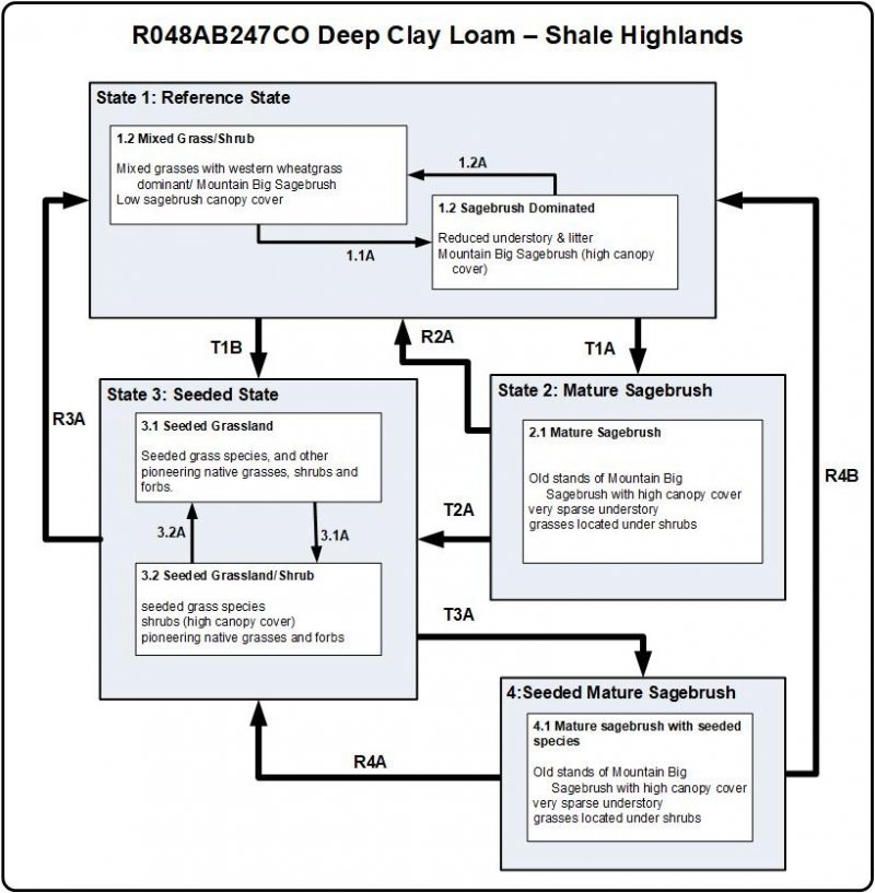
Ecological dynamics
This site is based on the range site Deep Clay Loam - R048XY247CO (SCS, 1976). This original site concept was written for the entire 48A MLRA, which covers the mountainous areas of Colorado. This ecological site is described and data collected primarily in the shale hills around the Montrose-Ridgeway area and a small area in the Gunnison Basin with a typic ustic soil moisture phase and cryic temperature regime. This site is treeless; however, trees are often in the general vicinity. This site is located below the spruce-fir tree line. The reference state is a cool season bunchgrass/shrub community. The appearance of this site is grassland in association with woody shrubs such as mountain big sagebrush, and several forbs. The dominant grass species are western wheatgrass, pine needlegrass, prairie Junegrass, bottlebrush squirreltail, Sandberg bluegrass, muttongrass, and upland sedges. The dominant shrub species is mountain big sagebrush. Yellow rabbitbrush and rubber rabbitbrush may be present in small amounts and will increase with some disturbances. Milkvetch, wild onion and yarrow are common on this site. These species account for most of the vegetative cover. There is a minor component of low-growing shrubs. Fluctuations in species composition and relative production may change from year to year depending upon precipitation and other climatic factors.
The Gunnison basin lies in the climatic zone where pinyon (Pinus edulis) and juniper (Juniperus osteosperma) normally occurs in other areas. But, due to the Gunnison Basin's unique ecological characteristics, the pinyon-juniper ecotone does not exist in the basin. But the intergradations zone with Wyoming big sagebrush and mountain big sagebrush do exist in the Gunnison Basin where you would normally find pinyon-juniper. Emslie, et al. (2005), state that the Gunnison Basin is recognized for its unusual ecological characteristics, including absence of certain plant taxa and vertebrates, The examples given is that pinyon pine is rare in the basin and absent is the western rattlesnake. The unique topography and climate of the Upper Gunnison Basin is what is thought to be the cause. Winters are extremely cold and cold air settles into the basin. Also, this area is drier than other regions at this elevation. It is thought that these factors of temperature, moisture and topography are responsible for the sagebrush dominated plant communities in the Upper Gunnison Basin (Emslie et al., 2005).
This ecological site is located in the Gunnison Basin which is in the transition zone from Wyoming big sagebrush to mountain big sagebrush; subsequently Bonneville hybrid will occur on this site between the other two subspecies. Mountain big sagebrush is found at elevations of 6800-8500 feet (Winward, 2004). Bonneville big sagebrush (Wyoming and mountain big sagebrush hybrid) has been found at the head of Long Gulch near Gunnison Colorado at about 8000 feet in elevation between the boundaries of Wyoming big sagebrush and mountain big sagebrush (Winward, 2004). UV fluorescent tests showed intergradations between the two subspecies and they occurred between 8-15 inches of precipitation with 12 inches being the average precipitation was where it was found (Goodrich et al., 1999). This ecological site is found at 14-19 inches of precipitation. Thus, Mountain big sagebrush and the hybrid will be on this site depending upon the position in regards to elevation and aspect in the basin. Johnson (2000) stated that mountain big sagebrush can be found growing with Wyoming big sagebrush.
Soils, topographic location, climate, periodic droughts and fire influenced the stabilization of the Reference State on this site as was the case on most high mountain valley ecological sites. The Reference State is presumed to be as found by European settlers in the early 1800's developed under the prevailing climate over time along with the soils in their topographic location. Grazing and/or browsing by wildlife influenced the plant community as well. The resulting plant community was a cool season bunchgrass/shrub community. Sagebrush taxa in Colorado above 8500 feet in elevation are in relatively good condition and appear to be recovering slowly from the impacts during the settlement period of the west (Winward, 2004). Sagebrush below 8500 feet has been slower to recover from settlement of the west (Winward, 2004). The high elevation valley of the Gunnison Basin sits in a transitional area where the climate and topographic location helped recovery of the sagebrush communities after European settlement of the west.
Natural fire played an important role in the function of most high mountain valley sites, especially the sagebrush communities. Grasses such as needlegrasses and bluegrasses were dependent upon fire to stimulate them. Fire also kept sagebrush stands from getting too dense, while invigorating other sprouting shrubs such as serviceberry and snowberry. Fire helped to keep a balance between the grasses, forbs and shrubs. Plant community dynamics was improved by opening up canopies and stimulating forb growth creating a mosaic of different age classes and species composition. Other than sagebrush, the deep rooted shrub species that grow on the site are not easily damaged by fire. Shrubs which re-sprout (yellow rabbitbrush, and snowberry), are suppressed for a time allowing grasses to dominate. If periodic fire does not occur, then sagebrush will slowly increase and can begin to dominate the site. Mountain big sagebrush communities are more prone to fire than Wyoming big sagebrush with fire return intervals (FRI) ranging from 10-115 years for Wyoming big sagebrush year (West and Hassan 1985, Evers, et al, 2011, Johnson, 2000). Mountain big sagebrush becomes dominant on this site if periodic burning or some other method of brush control is not used (10 to 50 year FRI) (Goodrich et al., 1999, Arno and Gruell, 1983, Evers, et al, 2011, Johnson, 2000). Fire size prior to 1850 were most likely a large number of small to medium size mosaic burns and since 1980 can be typified by a few very large fires due to human caused changes (Evers, et al, 2011). This change in fire return intervals and intensities was cause by fire suppression and reduced fine-fuels from livestock grazing practices around the late 1800’s and early 1900’s. Treatment response will vary among sites due to differences in vegetation composition and abundance, soils, elevation, aspect, slope and climate (McIver, et al, 2010). Since fire is not always available to be applied, then other practices may necessary from time to time to help keep the community in balance.
There has been shrub die-off in several sagebrush taxa in the past 10-15 years due to several factors. The two dominant factors are disease/pathogens and drought. Disease/pathogens to cause die-off are believed to be tied to disease or stem/root pathogens occurring in dense over-mature sagebrush stands throughout the west. It appears to be in older age sagebrush stands that most cases of disease/pathogen die-off are thinning sage densities. While in other cases, the factors of drought and heavy browsing occurring in conjunction with disease/pathogens complete areas are dying.
The major forces that influence the transition from the reference plant community are continuous season long grazing by ungulates and/or the decrease in the fire frequency. As ungulate numbers increase and grazing use exceeds a plant's ability to sustain defoliation, the more palatable and more productive species, and decline in stature, productivity and density.
Cheat grass is not typically found in this region due to the colder temperatures but it has been found primarily along roadsides, and campgrounds (Gasch and Bingham, 2006). A germination study of cheatgrass seeds collected in the Gunnison Basin showed significant differences in germination characteristics with regards to storage duration and germination temperature (Gasch and Bingham, 2006). This may indicate that cheatgrass is adapting to colder temperatures in the Gunnison Basin, but further study is needed (Gasch and Bingham, 2006). Based on evidence to date, cheatgrass is not found on this ecological site.
Variability in climate, soils, aspect and complex biological processes will cause the plant communities to differ. The species lists are representative and not complete list of all occurring or potentially occurring species on this site. The species lists are not intended to cover the full range of conditions, species and responses of the site. The State & Transition model depicted for this site is based on available research, field observations and interpretations by experts and could change as knowledge increases. This is the interpretive plant community and is considered to be the Reference Plant Community (RPC). This plant community evolved with grazing, fire, and other disturbances such as drought. This site is well suited for grazing by domestic livestock and wildlife and can be found on areas that are properly managed prescribed grazing.
State 1
Reference
Dominant view of potential plant community of this ecological site is from grasses and forbs with mountain big sagebrush in the overstory. Western wheatgrass is the principal specie. Muttongrass, Columbia needlegrass, Letterman needlegrass, mountain brome and squirreltail are frequently occurring grasses. Major forbs are silver lupine, milkvetch, wild onion, Indian paintbrush, and yarrow. Mountain big sagebrush is the most conspicuous shrub. Serviceberry, yellow rabbitbrush and snowberry grow in scattered stands. Although this site is commonly bordered by spruce-fir or aspen woodlands, few of these or other trees actually grow on the site. This site favors rhizomatous species like western wheatgrass and yarrow because of the vertic soil properties that occur naturally on this site.
This state represents the closest description and function of the site prior to European settlement. There are two dominant plant community phases in the reference state. Fire and drought are natural disturbances that change the pathways between community phases. Drought is frequent on this site and fires were of mixed intensity and frequency. Mountain big sagebrush sites it has on average 10-50 years FRI. Sagebrush species less than 50 years old are easily killed by fire (Miller and Eddleman, 2001). Most forb species which re-sprout from a caudex, corm, bulb, rhizome or rootstock exhibit rapid recovery following fire and suffrutescent low-growing or mat-forming forbs such as pussytoes or buckwheat can be severely damaged by fire (Miller and Eddleman, 2001).
Community 1.1
Mixed Grass/ Shrub

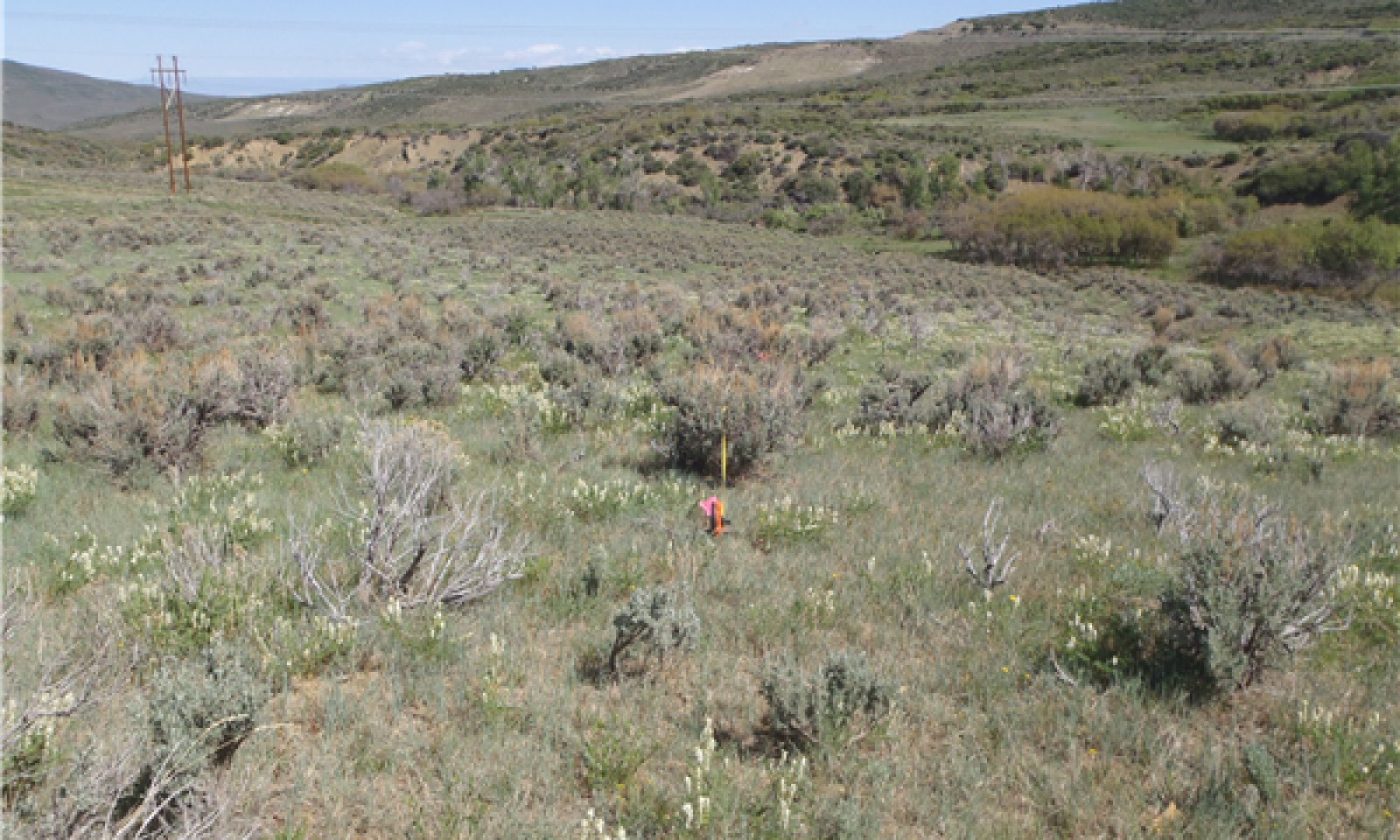
Figure 8. Landscape View
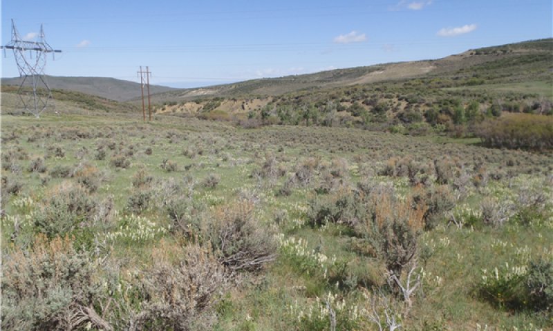
Figure 9. Landscape View
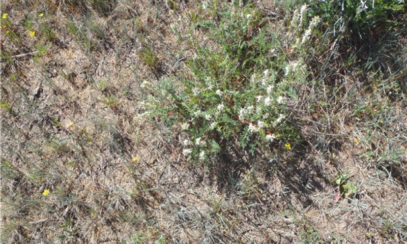
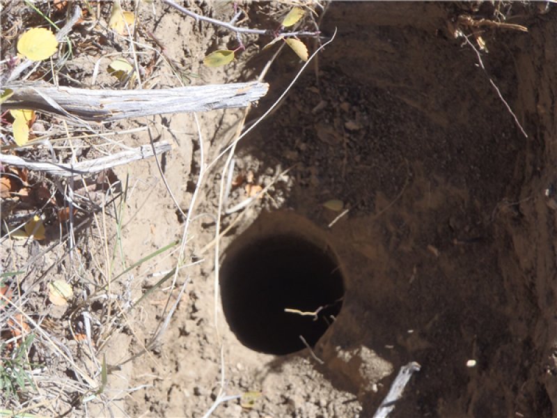
Figure 10. Close Up View
Dominant aspect of potential plant community of this ecological site is from grasses and forbs. Western wheatgrass, slender wheatgrass are the principal species. Subdominant grasses include muttongrass, Columbia needlegrass, Letterman’s needlegrass, mountain brome, and squirreltail. Major forbs are silver lupine, milkvetch, Indian paintbrush, wild onion and yarrow. Mountain big sagebrush is the most conspicuous shrub. Serviceberry and snowberry grow in scattered stands. Although this site is commonly bordered by spruce-fir or aspen woodlands and oak motts, few of these or other trees actually grow on the site. The approximate canopy cover of mountain big sagebrush is 0-20%.
Table 5. Annual production by plant type
| Plant type |
Low
(lb/acre) |
Representative value
(lb/acre) |
High
(lb/acre) |
| Grass/Grasslike |
900 |
1250 |
1525 |
| Forb |
400 |
500 |
650 |
| Shrub/Vine |
200 |
250 |
325 |
| Total |
1500 |
2000 |
2500 |
Table 6. Ground cover
| Tree foliar cover |
0%
|
| Shrub/vine/liana foliar cover |
5-35%
|
| Grass/grasslike foliar cover |
30-50%
|
| Forb foliar cover |
15-30%
|
| Non-vascular plants |
0-1%
|
| Biological crusts |
0-2%
|
| Litter |
10-30%
|
| Surface fragments >0.25" and <=3" |
0-2%
|
| Surface fragments >3" |
0%
|
| Bedrock |
0%
|
| Water |
0%
|
| Bare ground |
10-20%
|
Table 7. Canopy structure (% cover)
| Height Above Ground (ft) |
Tree |
Shrub/Vine |
Grass/
Grasslike |
Forb |
| <0.5 |
– |
15-30% |
25-40% |
5-15% |
| >0.5 <= 1 |
– |
15-30% |
25-40% |
5-15% |
| >1 <= 2 |
– |
10-20% |
10-25% |
2-8% |
| >2 <= 4.5 |
– |
0-15% |
0-5% |
0-2% |
| >4.5 <= 13 |
– |
– |
– |
– |
| >13 <= 40 |
– |
– |
– |
– |
| >40 <= 80 |
– |
– |
– |
– |
| >80 <= 120 |
– |
– |
– |
– |
| >120 |
– |
– |
– |
– |
| Jan |
Feb |
Mar |
Apr |
May |
Jun |
Jul |
Aug |
Sep |
Oct |
Nov |
Dec |
| J |
F |
M |
A |
M |
J |
J |
A |
S |
O |
N |
D |
Community 1.2
Sagebrush Dominated
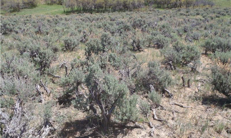
Figure 13. Landscape View
This community consists of a mountain big sagebrush dominated community with an increase in shrub cover and a decrease in the understory than the reference community. Grasses would include western wheatgrass, Sandberg bluegrass, prairie Junegrass and pine needlegrass. 20-40% mountain big sagebrush canopy cover would be present. The sagebrush would be moving towards a single age stand. Also, low shrubs such as yellow rabbitbrush and spineless horsebrush will increase and replace part of the herbaceous component in the understory. Lack of an understory helps to suppress low intensity fires as there is no fuel to carry the fire unless it is a high intensity fire. Increased sagebrush canopy can be due to lack of disturbance such as wildfire. Cumulating effects of degrading sagebrush habitats could include: higher erosion and sedimentation, decreased water quality, declines in forage base for domestic livestock, and decreased habitat for wildlife species (McIver, et al, 2010). This phase is losing species diversity compared with phase 1.1.
| Jan |
Feb |
Mar |
Apr |
May |
Jun |
Jul |
Aug |
Sep |
Oct |
Nov |
Dec |
| J |
F |
M |
A |
M |
J |
J |
A |
S |
O |
N |
D |
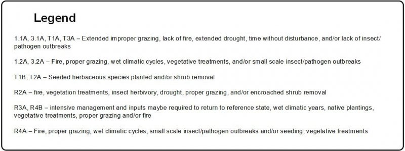
Pathway 1.1A
Community 1.1 to 1.2
Natural occurring fire return intervals and intensities would characterize this pathway (McIver, et al, 2010). Brush management can be used to mimic this pathway. Drought and prescribed grazing or improper grazing can influence the timeframe of this community pathway. Short term drought during the winter and early spring will facilitate to increase the understory. Grasses respond quicker and take advantage of mid-summer and late summer moisture where the shrubs do not
| Brush Management |
|
| Fence |
|
| Prescribed Grazing |
|
Pathway 1.2A
Community 1.2 to 1.1
Fires occurring within the naturally occurring fire return intervals (10-50 years) would characterize this pathway. Total herbage production of grasses reach a maximum 2-5 years after burning after which it declines as sagebrush and other shrubs species increase; increased grass cover is short lived; forb cover has been found to have greater biomass 5-15 years after burning (Nelle et al, 2000). Improper grazing can decrease the understory; increase sagebrush canopy and shorten the time span it takes to transition back to reference community phase 1.1. Extended drought and improper grazing can change the time frame of this transition. Improper browsing and suitable grazing on the understory species can cause this shift, along with frequent fires prior to seed set for the sagebrush but after seed set for the understory, and large scale insect or pathogen die-off of the sagebrush could cause this pathway (Evers et al, 2011).
State 2
Mature Sagebrush
State 2 is a sagebrush dominated community. This state has an increase in shrub cover and a decrease in the understory cover from State 1. The sagebrush community is an even structured single age stand. Also, low shrubs such as yellow rabbitbrush will increase and replace part of the herbaceous component in the understory. This state has lower species diversity than State 1. Improper grazing management practices that lead to decreased deep rooted understory species can lead to compaction in the soil, erosion from lack of plant canopy, decreased organic matter in the soil, and increased soil exposure due to reduction in the litter cover. Sagebrush canopy cover would be >45%.
Community 2.1
Mature Mountain Big Sagebrush
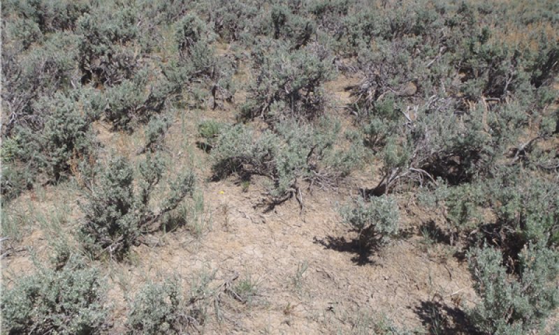
Figure 15. Landscape View
This state has a very dense stand of Mountain big sagebrush with little to no understory. There may be a few remnant herbaceous plants under the sagebrush but the number of understory plants left would not be able to re-seed the site if there was a disturbance. This state is comprised predominantly of shrubs consisting of Mountain big sagebrush and yellow rabbitbrush. Trace amounts of Sandberg bluegrass, pine/Letterman’s needlegrass may be present. Lack of an understory helps to suppress low intensity fires as there is a lack of fine fuels load to carry a low intensity fire; however, with high canopy cover, high intensity crown fires are a threat to this community. Increased sagebrush canopy can be due to lack of disturbance such as wildfire. Cumulating effects of degrading sagebrush habitats include higher erosion and sedimentation, decreased water quality, declines in forage base for domestic livestock, and decreased habitat for wildlife species (McIver, et al, 2010). This phase is losing species diversity compared with phase 1.1.
| Jan |
Feb |
Mar |
Apr |
May |
Jun |
Jul |
Aug |
Sep |
Oct |
Nov |
Dec |
| J |
F |
M |
A |
M |
J |
J |
A |
S |
O |
N |
D |
State 3
Seeded
This state is characterized by the fact that sagebrush has been removed due to fire and/or shrub management treatments. Shrub management treatments may include techniques such as chaining, disking, or mowing. The community dynamics are similar to the reference state. This state could persist for long periods of time. Sagebrush will start to re-establish when the conditions are right for it to do so. This site has been historically seeded to perennial species such as smooth brome, intermediate wheatgrass, western wheatgrass, thickspike wheatgrass and Russian wildrye.
Due to changes in the soil properties and seeded plants, this site is not likely to return to the Reference State without active restoration practices.
Community 3.1
Seeded Grassland
This state is characterized by introduced perennial grasses. This site is seeded to perennial species such as intermediate wheatgrass, orchard-grass, smooth brome and Russian wildrye. Sagebrush would reestablish from seed coming in from adjacent areas or in the seed bank after the land was seeded to the introduced grasses. Sandberg bluegrass and western wheatgrass would slowly establish in small amounts into this plant community phase. This community phase will need maintenance to remain in 3.1 by either fire or shrub management This pathway will cause short term topsoil loss and in turn reduction in water holding capacity of the soil at the surface as the understory is reduced and present to prevent runoff. The sagebrush canopy cover would be 0-20% and the herbaceous understory component has 30-40% canopy cover.
| Jan |
Feb |
Mar |
Apr |
May |
Jun |
Jul |
Aug |
Sep |
Oct |
Nov |
Dec |
| J |
F |
M |
A |
M |
J |
J |
A |
S |
O |
N |
D |
Community 3.2
Seeded Grassland/Shrub
This state is characterized by introduced perennial grasses which could include perennial species such as intermediate wheatgrass and Russian wildrye. This community phase will need maintenance to remain in this community phrase 3.2 by either fire or shrub management.
This community would consist of seeded perennial grass such as Russian wildrye and intermediate wheatgrass with mountain big sagebrush established as the overstory species. This would result from sagebrush seed coming in from adjacent areas or in the seed bank after the land was seeded to the introduced grasses. Also, mountain big sagebrush could be in a species in the seed mix when the seeding occurred. The canopy of sagebrush cover would be approximately 20-40%.
| Jan |
Feb |
Mar |
Apr |
May |
Jun |
Jul |
Aug |
Sep |
Oct |
Nov |
Dec |
| J |
F |
M |
A |
M |
J |
J |
A |
S |
O |
N |
D |
Pathway 3.1A
Community 3.1 to 3.2
The natural pathway is lack of fire over time. Improper grazing on the understory species and little to no seedling establishment or regeneration time with result in increased sagebrush canopy cover and establishment.
Pathway 3.2A
Community 3.2 to 3.1
Proper grazing and wet climatic periods can move this community towards community phase 3.1. Shrub management including herbicides can be used to mimic the pathways. Pathogens and insect mortality of establishing sagebrush can influence this pathway. Short term drought during the winter and early spring will facilitate to increase the understory. Grasses respond quicker and take advantage of mid-summer and late summer moisture where the shrubs do not.
State 4
Seeded Mature Sagebrush
State 4 would be a sagebrush dominated community; This state would have an increase in shrub cover and a decrease in the understory cover. The sagebrush community would be an even structured single age stand. Introduced species would have decreased in this state. Also, low shrubs such as yellow rabbitbrush and spineless horsebrush will increase and replace part of the herbaceous component in the understory. This state has low species diversity. Improper grazing management practices that lead to decreases deep rooted understory.
Community 4.1
Mature Mountain Big Sagebrush/ Introduced grasses
This state has greater than 45% live canopy cover of mountain big sagebrush. The understory is reduced so that there is little to no grass and forb cover in the interspaces. The grass and forb cover left will be found in directly under the canopy of the Wyoming big sagebrush plants. Also, there is active soil erosion.
| Jan |
Feb |
Mar |
Apr |
May |
Jun |
Jul |
Aug |
Sep |
Oct |
Nov |
Dec |
| J |
F |
M |
A |
M |
J |
J |
A |
S |
O |
N |
D |
Transition T1A
State 1 to 2
Improper grazing for extended periods during the growing season can reduce the fine fuels of the understory and thus, favor sagebrush encroachment. Lack of fire over time can cause this transition (McIver, et al, 2010). Extended periods of drought, lack of insect and pathogen activity can influence this pathway to create a more single age stand of sagebrush. This transition is characterized by loss of the understory and increased bare ground between the shrubs and/or other evidence of increased soil erosion. Fine fuels depletion due to inappropriate grazing has shifted fire regimes, from relatively frequent and low to mixed severity (10-70 years mean FRI) to more frequent and high severity (>70 years mean FRI).
Transition T1B
State 1 to 3
This transition is human induced through shrub management, prescribed burning and/or reseeding with introduced species after a catastrophic wildfire.
Restoration pathway R2A
State 2 to 1
Proper grazing, wet climatic periods, fire after seed set of the understory, and small scale insect and pathogen mortality of shrubs can move this community towards diverse understory and away from the dense single age stand of sagebrush (Evers et al, 2011). Shrub management including herbicides, prescribed burning can be used to mimic the pathways and seeding with natives after treatment.
Transition T2A
State 2 to 3
This transition is human induced through shrub management, prescribed burning and/or reseeding with introduced species after a catastrophic wildfire.
Restoration pathway R3A
State 3 to 1
This site could be restored to resemble the reference site of western wheatgrass and mountain big sagebrush community by seeding mixtures of commercially available native grasses, forbs, and shrubs. Selective remove of introduced species might be needed also, to restore this site. With proper management, over time this site can be come close to the diversity and complexity of the reference state. This can be an intensive option on a large scale.
Transition T3A
State 3 to 4
Improper grazing for extended time frames and lack of fire are the main pathways. Extended drought can influence the production of the understory and combine with improper grazing can reduced this state back to a mature/single age shrub community with a few introduced seeded understory species found mostly under the canopy of the shrubs.
Restoration pathway R4B
State 4 to 1
This site could be restored to resemble the reference site of Western Wheatgrass and Mountain big sagebrush community by seeding mixtures of commercially available native grasses, forbs, and shrubs. Selective remove of introduced species might be needed also, to restore this site. With proper management, over time this site can be come close to the diversity and complexity of the reference state. This can be an intensive option on a large scale.
Restoration pathway R4A
State 4 to 3
Fire and wetter climatic periods can cause the mature/single age shrub communities to go back to a grassland state if proper grazing strategies are implemented. This will only happen if enough seed is in the seed bank to regenerate the understory species. If the seed or mature plants are not available for this pathway then the site may need to be re-seeded. Shrub management practices such as prescribed burning, prescribed grazing and seeding could be used to assist in moving this state 4 to state 3.