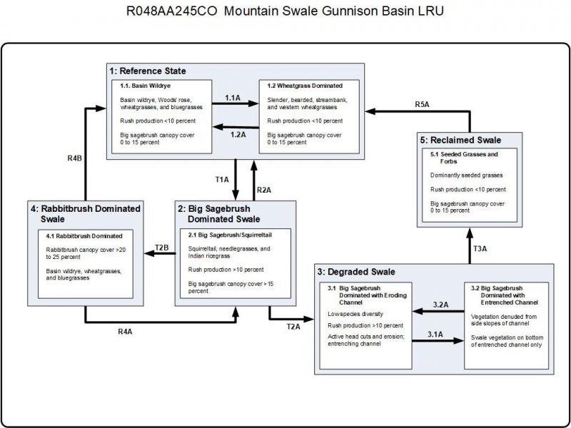
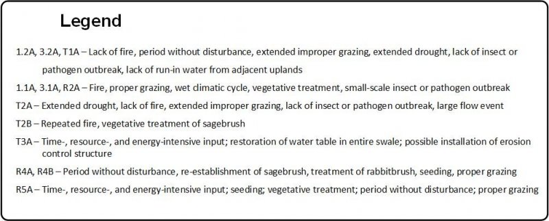
Ecological dynamics
The description of this site is based on the description of the Mountain Swale (R048XY245CO) range site (USDA-SCS, February 1976). The original concept included all of MLRA 48A, which covers the mountainous areas of Colorado. This ecological site describes data collected primarily for the high mountain areas of the Gunnison Basin. The soil moisture regime is typic ustic, and the soil temperature regime is cool frigid bordering on warm cryic. This site is in draws, on the bottom of small valleys, and in drainageways of high mountain valleys in MLRA 48A. Herbivory and fire are the dominant disturbance factors in the sagebrush biome (Boyd et al., 2014). Absence or repeated incidences of these disturbances may result in a shift in the ecological dynamics. The ecological dynamics of the associated uplands also influence the dynamics of this site. Excessive runoff and erosion from degraded uplands can increase the concentrated flow and potential for formation of gullies. Frequent fires remove brush and help to maintain the grassland.
The Gunnison Basin is in a climatic zone where pinyon (Pinus edulis) and juniper (Juniperus osteosperma) normally occur; however, the basin generally does not support these species because of its unique ecological characteristics. The basin does support intergradations of Wyoming big sagebrush and mountain big sagebrush. The Gunnison Basin is recognized for its unusual ecological characteristics, including absence of certain plants and vertebrates. Pinyon pine is rare in the basin, and western rattlesnake is absent. Winters are extremely cold, and the cold air settles into the basin. Also, this area is drier than other regions at similar elevations. It is thought that the temperature, moisture, and topography are responsible for the sagebrush-dominant plant communities in the Upper Gunnison Basin (Emslie et al., 2005). Black sagebrush has a taproot and wide-spreading lateral roots. The shallow soils associated with this site prevent development of deep roots; thus, they support plants that have more fibrous roots than does big sagebrush (Fryer, 2009). The shallow soils also prevent deep-rooted trees from invading the site, which allows black sagebrush to remain dominant.
The Gunnison Basin is in the transition zone from Wyoming big sagebrush to mountain big sagebrush. Wyoming big sagebrush generally is in areas that receive 7 to 12 inches of precipitation and are at an elevation of 1,000 to 6,000 feet, but in Colorado it may be in areas of well drained soils at an elevation of as high as 8,000 feet. Mountain big sagebrush is at an elevation of 6,800 to 8,500 feet. Bonneville big sagebrush, a hybrid of Wyoming big sagebrush and mountain big sagebrush, has been observed at the head of Long Gulch near Gunnison, Colorado, at an elevation of about 8,000 feet (between the boundaries of Wyoming big sagebrush and mountain big sagebrush; Winward, 2004). Ultraviolet fluorescent tests showed intergradations between the two subspecies in areas that receive 8 to 15 inches of precipitation (Goodrich et al., 1999). This ecological site is in areas that receive 12 to 16 inches of effective precipitation and are at an elevation of 7,200 to 8,200 feet; thus, both the subspecies and the hybrid may be in this site, depending on elevation and aspect. Mountain big sagebrush may grow in areas with Wyoming big sagebrush (Johnson, 2000).
The soils, topographic location, climate, and periodic drought and fire influence the stability of the reference state. The reference state is presumed to be the community encountered by European settlers in the early 1800's that developed under the prevailing climate over time. Grazing and browsing by wildlife also influenced the plant community. The resulting plant community is a cool-season bunchgrass/shrub community. Sagebrush communities in Colorado above an elevation of 8,500 feet are in relatively good condition and appear to be recovering slowly from the impacts of settlement in the west. Sagebrush communities below an elevation of 8,500 feet have been slower to recover (Winward, 2004). This site supports mountain big sagebrush, Wyoming big sagebrush, and Bonneville big sagebrush; therefore, the big sagebrush (ARTR2) in the “Plant Community Composition” table includes all three species.
Natural fire plays an important role in the function of most sites in high mountain valleys, especially the sagebrush communities. Fire stimulates growth of grasses such as needlegrasses and bluegrasses. It also helps to keep sagebrush stands from becoming too dense and invigorates other sprouting shrubs such as serviceberry and snowberry. Fire helps to maintain a balance among grasses, forbs, and shrubs. The dynamics of a plant community are improved by opening the canopy and stimulating growth of forbs, creating a mosaic of different age classes of species and a diverse composition of species in the communities. Other than Wyoming big sagebrush, the deep-rooted species that grow on the site are not easily damaged by fire (BLM, 2002). Shrubs that resprout, such as yellow rabbitbrush and spineless horsebrush, are suppressed for a period. This allows grasses to become dominant. If periodic fires or other methods of brush control are not used, sagebrush slowly increases in abundance and can become dominant.
Wyoming big sagebrush plant communities have lower productivity and fuel loads, less ground cover, lower crown cover of shrubs, and less diversity in species and structure than do mountain big sagebrush plant communities (Goodrich et al., 1999; West and Hassan, 1985; Evers, et al., 2011; Johnson, 2000). Wyoming big sagebrush communities are less prone to fire than are mountain big sagebrush communities. The fire return interval for Wyoming big sagebrush communities in the western United States is 10 to 115 years (West and Hassan, 1985; Evers, et al., 2011; Johnson, 2000). The fire return interval for Wyoming big sagebrush varies greatly depending on differences in precipitation and temperature; it is about 10 to 70 years in the uplands of the Gunnison Basin. Big sagebrush in mesic habitats is subject to more frequent fires. The fire return interval for mountain big sagebrush in mesic habitats is 12 to 25 years (Boyd et al., 2014).
Prior to 1850, the fires typically consisted of a large number of small- to medium-sized mosaic burns. Since 1980, the fires typically consist of a few very large burns caused by human activity (Evers et al., 2011). The change in the fire return interval and intensity of fires is a result of fire suppression and reduced fine fuel from livestock grazing in the late 1800’s and early 1900’s. Other shrub management practices may be needed to help keep the community in balance. The response to treatment varies among sites due to differences in the composition and abundance of vegetation, soils, elevation, aspect, slope, and climate (McIver, et al, 2010).
Several sagebrush taxa have been subject to die-off in the past 10 to 15 years. The dominant factors are disease (pathogens) and drought. Disease and stem and root pathogens have caused die-off dominantly in dense, over-mature sagebrush stands throughout the west. Drought and heavy browsing in conjunction with pathogens have caused complete die-off in other areas.
Water may accumulate in narrow, small valley bottoms. These areas may support willows, sedges, and rushes and communities of the Mountain Meadow ecological site. Narrowleaf cottonwood may be in these areas (USDA-SCS, 1976). Narrowleaf cottonwood is a facultative wetland species that is tolerant of frequent, prolonged periods of flooding and is not resistant to drought (Simonin, 2001). Typically, this site is too dry to sustain cottonwood.
Variability in climate, soils, aspect, and complex biological processes results in differing plant communities. The composition and relative productivity of species may fluctuate from year to year, depending on precipitation and other climatic factors. The species listed in this description are representative; not all occurring or potentially occurring species are listed. The species listed do not cover the full range of conditions and responses of the site. The state-and-transition model is based on available research, field observations, and interpretations by experts; changes may be needed as knowledge increases. The reference plant community is the interpretive community. This plant community evolved as a result of grazing, fire, and other disturbances such as drought. This community is well suited to grazing by domestic livestock and wildlife, and it is in areas that are properly managed by prescribed grazing.
State 1
Reference
This state is on gently sloping valley bottoms that receive excess runoff from well-managed surrounding uplands. The plant community is very productive because of the extended growing season as compared to the uplands. An ephemeral channel that is not entrenched or downcutting is typical. The reference state is stable and has properly functioning hydrology.
The reference state consists of grassland that has minor amounts of forbs and shrubs. The dominant grasses are basin wildrye, slender wheatgrass, western wheatgrass, Letterman’s needlegrass, pine needlegrass, and sedges. Forbs include geranium, herbaceous cinquefoil, American bistort, and yarrow. Minor amounts of big sagebrush and rabbitbrush are present, but they may become more dominant as the site begins to deteriorate (USDA-SCS, 1976).
Notable patch dynamics influence pockets of vegetation. For example, a greater dominance of western wheatgrass and basin wildrye is near the toeslopes of the hills and in high areas. Western wheatgrass is dominant in drier areas associated with finer textured soils. Basin wildrye is not suited to saturated soils; it commonly is best suited to well drained soils that are subject to periodic water events throughout the growing season. Bunch bluegrasses, bromes, and other wheatgrasses increase in prevalence closer to the channel. Forbs and preferred shrubby species such as snowberry, Woods’ rose, and willows also increase. The high diversity of species in this state allows plants to adapt to periods of additional moisture or drought.
Community 1.1
Basin Wildrye
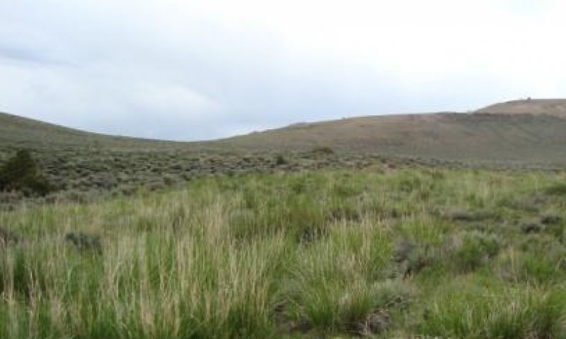
Figure 9. Typical area of community 1.1.
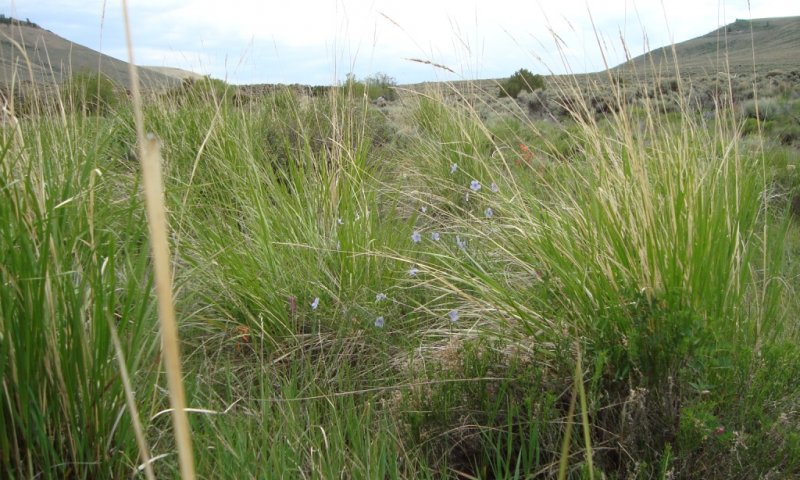
Figure 10. Typical area of community 1.1.
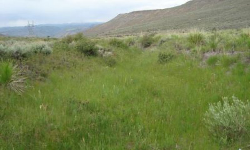
Figure 11. Typical area of community 1.1.
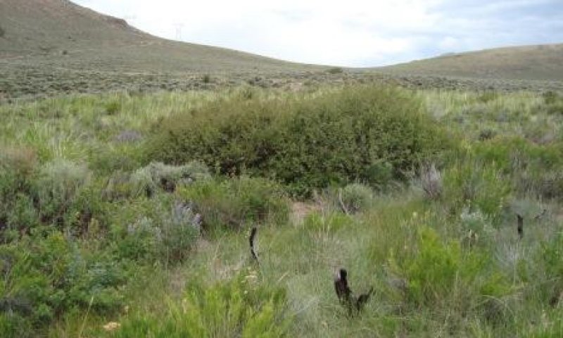
Figure 12. Typical area of community 1.1.
This community phase typically consists dominantly of basin wildrye, western wheatgrass, streambank wheatgrass (thickspike wheatgrass [AGRI3]), slender wheatgrass (Trachycaulus ssp. [ELTRT]), bearded wheatgrass (Subsecundus ssp. [ELTRS]), and bunch bluegrasses. Generally, grasses and rushes make up 60 to 75 percent of the total annual production, forbs 15 to 25 percent, and shrubs 10 to 20 percent. In a normal year, the annual production is 2,000 to 3,000 pounds. The diverse community consists of 15 to 20 species or more, which help to stabilize it. A decrease in the diversity of species is one of the first indicators of site deterioration. Key species that indicate a pristine, well-functioning system include nodding brome (Porter’s brome [BRPO2]), mountain brome, western needlegrass, and occasionally meadow barley, snowberry, geranium, and alumroot. Species that increase in abundance under disturbance and indicate deterioration of the site include rush, big sagebrush, fleabane, herbaceous cinquefoil, bottlebrush squirreltail, foxtail barley, horsetail, Rocky Mountain iris, and rabbitbrush. The canopy cover of big sagebrush is less than 15 percent, and the annual production of rush is less than 10 percent.
Table 5. Annual production by plant type
| Plant type |
Low
(lb/acre) |
Representative value
(lb/acre) |
High
(lb/acre) |
| Grass/Grasslike |
1300 |
1625 |
1950 |
| Shrub/Vine |
400 |
500 |
600 |
| Forb |
300 |
375 |
450 |
| Total |
2000 |
2500 |
3000 |
Table 6. Ground cover
| Tree foliar cover |
0-1%
|
| Shrub/vine/liana foliar cover |
1-20%
|
| Grass/grasslike foliar cover |
50-70%
|
| Forb foliar cover |
5-15%
|
| Non-vascular plants |
0%
|
| Biological crusts |
0%
|
| Litter |
20-50%
|
| Surface fragments >0.25" and <=3" |
0-5%
|
| Surface fragments >3" |
0%
|
| Bedrock |
0%
|
| Water |
0-1%
|
| Bare ground |
0-10%
|
Table 7. Canopy structure (% cover)
| Height Above Ground (ft) |
Tree |
Shrub/Vine |
Grass/
Grasslike |
Forb |
| <0.5 |
– |
– |
15-20% |
1-5% |
| >0.5 <= 1 |
– |
1-2% |
25-35% |
5-15% |
| >1 <= 2 |
0-1% |
1-2% |
20-40% |
1-3% |
| >2 <= 4.5 |
0-1% |
0-5% |
1-10% |
– |
| >4.5 <= 13 |
0-1% |
0-5% |
– |
– |
| >13 <= 40 |
0-1% |
– |
– |
– |
| >40 <= 80 |
– |
– |
– |
– |
| >80 <= 120 |
– |
– |
– |
– |
| >120 |
– |
– |
– |
– |
| Jan |
Feb |
Mar |
Apr |
May |
Jun |
Jul |
Aug |
Sep |
Oct |
Nov |
Dec |
| J |
F |
M |
A |
M |
J |
J |
A |
S |
O |
N |
D |
Community 1.2
Wheatgrass Dominated Swale
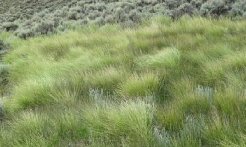
Figure 15. Wheatgrass dominated community.
This community phase is a result of continuous grazing by domestic livestock. Wheatgrasses, commonly western wheatgrass, provide more than 50 percent of the production in this community. Most of the production is from four or five plant species. The annual production is about 2,000 to 3,000 pounds per acre, which is similar to that of the reference community.
This community phase is moderately stable. It is somewhat vulnerable to erosion due to the bare ground between the plants. The biotic integrity of the plant community commonly is intact, and the watershed commonly is functioning. The community can be at risk if the canopy cover of big sagebrush or the amount of bare ground increases.
| Jan |
Feb |
Mar |
Apr |
May |
Jun |
Jul |
Aug |
Sep |
Oct |
Nov |
Dec |
| J |
F |
M |
A |
M |
J |
J |
A |
S |
O |
N |
D |
Pathway 1.1A
Community 1.1 to 1.2
Wheatgrass Dominated Swale
Disturbances such as fire and improper grazing use by wildlife and domestic livestock can cause a shift to a less diverse community that is dominantly wheatgrasses. Under improper grazing, cool-season bunchgrasses, such as basin wildrye, decrease in abundance and production.
Pathway 1.2A
Community 1.2 to 1.1
Wheatgrass Dominated Swale
Proper grazing use, presence of favorable propagules, and time allow for the wheatgrass-dominated community to transition to the more diverse reference plant community. Brush management practices may be needed if the abundance of sagebrush and the amount of bare ground have increased. Care should be taken when planning these practices to consider the value of wildlife habitat.
State 2
Big Sagebrush Dominated
Rush, big sagebrush, fleabane, herbaceous cinquefoil, bottlebrush squirreltail, foxtail barley, horsetail, and rabbitbrush are dominant in this state. The hydrologic function of this community is intact throughout the swale; no benches or entrenched channels are present. The water has access to the entire swale, which helps to dissipate the energy and minimize the effects of flooding. This state is unstable and at the edge of a major threshold. If it is left untreated, it likely will transition to a degraded state and a high flow event could permanently alter the hydrologic function.
Degradation of upland areas influences the transition of this site from a functioning hydrology and preferred plant communities to this highly unstable community. Upland areas that develop a dense, old stand of sagebrush and minimal understory dewater swales by increasing the overland flow and loss through evaporation and decreasing the ability to capture and store water. Removal of grasses and herbaceous litter from the soil surface increases the rate of the flow of water and decreases infiltration. Water that could have been transported, infiltrated, stored, and moved to the swale at a later time is added to the already erosive overland flow; thus, larger amounts of water and sediment are flowing into the swale more rapidly and in a shorter period. Minor changes in the microclimate, especially at the periphery of swales, allow sagebrush and other obligate upland species to advance into the swales, which further dries them out.
Community 2.1
Big Sagebrush/Squirreltail
The annual production of big sagebrush makes up 15 to 20 percent of the total production of this community, and the canopy cover of big sagebrush makes up 35 percent or more of the plant community. The diversity of this community is similar to that of the reference plant community; it commonly supports 15 to 20 species. Unlike the reference plant community, however, a larger proportion of the plants are upland species that have invaded the swales. Species such as bottlebrush squirreltail, Letterman’s needlegrass, pine needlegrass, muttongrass, and upland sedges commonly indicate a transition to an altered hydrologic function. Because rush grows mainly early in spring when moisture is available and does not need sustained moisture throughout the growing season, it becomes a dominant species. Treatment may be needed if the production of rush is more than 10 percent of the total production of the community.
Total production of this community is 1,200 to 1,600 pounds per acre. The dominant plants have changed from grasses to big sagebrush. This reduces the amount of fine organic material on the surface that helps to protect the soil from erosion and reduces organic matter content in the soil. Moderate and large flows can result in excessive erosion. The swales are at risk for developing deeply eroded channels and contributing higher sediment loads in streams.
| Jan |
Feb |
Mar |
Apr |
May |
Jun |
Jul |
Aug |
Sep |
Oct |
Nov |
Dec |
| J |
F |
M |
A |
M |
J |
J |
A |
S |
O |
N |
D |
State 3
Degraded
This state is degraded, and the hydrology is altered. The plant community and surface debris are insufficient to slow runoff and dissipate the erosive energy of the water. During flow events, the amount of fine organic material on the surface is not sufficient to stabilize the soil, slow the flow of water, and allow for infiltration. Water from the uplands builds energy as it collects in the swales and forms channels. The swales cannot dissipate the energy; thus, channelization increases and head cuts form. The channel also begins to drain subterranean water, further dewatering the system in a self-perpetuating loop. Soils in these areas may have a thinner A horizon (7 inches or less).
Due to the dewatering of swales that support dominantly sagebrush, production is drastically reduced to 500 to 700 pounds per acre. Diversity of the plant community is limited to three or four species, and rush is one of the major components. The amount of bare ground is 10 to 15 percent or more.
This state has two fluctuating phases. Both phases have an entrenched channel, and water has no access to the flood plain of the swales. The plant community in the channel may be similar to that of the reference state, but the majority of the swale supports a degraded sagebrush community that produces a fraction of its original potential. The least stable fluctuating community phase is subject to excessive erosion during a flow event. No vegetation is on the sidewalls or bottom of the channel. It has a distinctly V-shaped channel that widens and deepens during each flow event. In the other fluctuating community phase, the bottom of the channel is revegetated. The vegetation is similar to that of the reference community. Since the water is consolidated in a smaller area, the soils have a higher potential for exhibiting gleying and redoximorphic features. This is indicative of the low levels of oxygen associated with a water table. Common plants in the channel are those that are tolerant of flooding; thus, the abundance of obligate and facultative wetland species is higher as compared to the reference plant community. The vegetation helps to stabilize the channel during periods of minor or moderate flooding and prevent further degradation. Commonly, the channel in this phase is U-shaped.
Community 3.1
Big Sagebrush Dominated Eroding Channel
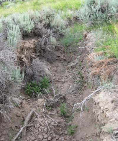
Figure 18. Big sagebrush dominated swale that has an actively eroding channel.
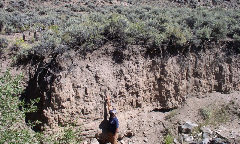
Figure 19. Big sagebrush dominated swale that has an actively eroding channel.
This community is the least stable in this state. It has an actively eroding channel and active head cuts at the top of the channel. Excessive erosion occurs during flow events due to the lack of vegetation on the sidewalls and bottom of the channel. The channel commonly is V-shaped, and it widens and deepens during each flow event. The amount of bare ground is increased. The herbaceous production is 500 to 700 pounds per acre. Rush makes up more than 10 percent of the total production of the community. The diversity of the community is very low, and few forbs are present. Eventually, the partially abandoned swale will look like a dry sagebrush “bench” above a narrow channel.
| Jan |
Feb |
Mar |
Apr |
May |
Jun |
Jul |
Aug |
Sep |
Oct |
Nov |
Dec |
| J |
F |
M |
A |
M |
J |
J |
A |
S |
O |
N |
D |
Community 3.2
Big Sagebrush Dominated with Incised Channel
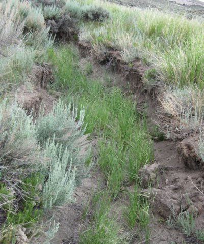
Figure 21. Big sagebrush dominated swale that is not subject to active erosion.
In this community phase, the bottom of the channel is revegetated with plants similar to those in the reference community. Since the water is consolidated in a smaller area, the soils have a higher potential for exhibiting gleying and redoximorphic features. This is indicative of the low levels of oxygen associated with a water table. Common plants in the channel are those that are tolerant of prolonged periods of flooding; thus, the abundance of obligate and facultative wetland species is higher as compared to the reference plant community. The vegetation helps to stabilize the channel during periods of minor or moderate flooding. Commonly, the channel in this phase is U-shaped. The side slopes are denuded and subject to erosion. A sagebrush “bench” (elevated top slopes that have relict reference state vegetation) may be along a narrow, entrenched channel.
| Jan |
Feb |
Mar |
Apr |
May |
Jun |
Jul |
Aug |
Sep |
Oct |
Nov |
Dec |
| J |
F |
M |
A |
M |
J |
J |
A |
S |
O |
N |
D |
Pathway 3.1A
Community 3.1 to 3.2
Big Sagebrush Dominated Eroding Channel
Big Sagebrush Dominated with Incised Channel
Stabilizing the actively eroding areas of the swale with vegetation and ground cover helps to prevent further deterioration. Practices that promote growth of vegetation aid in this pathway.
Pathway 3.2A
Community 3.2 to 3.1
Big Sagebrush Dominated with Incised Channel
Big Sagebrush Dominated Eroding Channel
Seasonal drought, improper grazing use, fire, and large flow events may contribute to further degradation of the swale.
State 4
Rabbitbrush Dominated
If sagebrush is removed by chemical treatment, mowing, or fire, resprouting rabbitbrush will become dominant.
Community 4.1
Rabbitbrush Dominated Swale
Rabbitbrush production makes up 15 to 20 percent of the annual production of the community. Rabbitbrush commonly sprouts vigorously after the above-ground biomass is removed. Although this is not the preferred community, rabbitbrush does not restrict the production of grasses and forbs as does sagebrush. It may take several years of chemical treatment to return this community to the reference plant community.
| Jan |
Feb |
Mar |
Apr |
May |
Jun |
Jul |
Aug |
Sep |
Oct |
Nov |
Dec |
| J |
F |
M |
A |
M |
J |
J |
A |
S |
O |
N |
D |
State 5
Reclaimed
This community is a man-made community. Intensive inputs of time, energy, and resources are needed to restore the level of the water table to the floor of the swale instead of the bottom of the channel.
Community 5.1
Reclaimed Swale
This community phase is characterized by restoration of the level of the water table to the floor of the swale. Commonly, a large amount of site work is needed. Site work may include soil movement, brush removal, and installation of check dams to reclaim the community, but it may never be restored to the reference plant community. Areas directly behind the check dams commonly have a higher water table, which promotes growth of facultative and obligate wetland species. Areas directly below the structures do not receive the subterranean flow that was present in the original swale; thus, they are drier. This promotes invasion of upland species that typically are not in the reference plant community. Buildup of sediment in the check dams needs to be monitored. Seeding is needed to help stabilize the community.
| Jan |
Feb |
Mar |
Apr |
May |
Jun |
Jul |
Aug |
Sep |
Oct |
Nov |
Dec |
| J |
F |
M |
A |
M |
J |
J |
A |
S |
O |
N |
D |
Transition T1A
State 1 to 2
Sagebrush encroachment from adjacent upland communities as a result of prolonged drought, lack of fire, and improper grazing can alter the plant community, leaving the soils subject to erosion and altering the hydrological function. The mean fire return interval is 12 to 25 years in mesic habitats (Boyd et al., 2014). Lack of wet periods may shift the community from a grass-dominant state (State 1) to a sagebrush-dominant state (State 2).
Restoration pathway R2A
State 2 to 1
State 2 can be restored to the reference state (State 1) by removing sagebrush with fire or other treatments and applying proper grazing use by domestic livestock and wildlife. Management practices that restore the health of the upland community are critical to return the community to the reference state. Suitable practices include prescribed fire, shrub management, and proper grazing management. Several consecutive wet years also can decrease the abundance of big sagebrush because its roots are not tolerant of wetness for extended periods.
Transition T2A
State 2 to 3
Due to a lack of protection on the soil surface, large flow events quickly destabilize the site and the hydrological function is altered (State 3). Practices that further reduce the ground cover, such as improper grazing, and prolonged periods of drought can speed up this transition. Fire suppression and lack of shrub management in uplands areas that support decadent sagebrush communities promote alteration of the hydrologic function and destabilization of the swale.
State 3 is an unstable community that affects soil health and the hydrologic function as it becomes invaded by big sagebrush. Gullies and head cuts form due to the lack of adequate herbaceous cover to dissipate the velocity of the water flow and encourage infiltration.
Transition T2B
State 2 to 4
Repetitive burning of big sagebrush favors growth of rabbitbrush and perennial grasses, especially basin wildrye. Mechanical and chemical removal of sagebrush encourages growth of rabbitbrush. This may be affected by the timing of treatment or the weather patterns in years following treatment.
Transition T3A
State 3 to 5
Restoring either of the community phases in State 3 to the reference plant community would require intensive inputs of time, resources, and energy. The level of the water table needs to be returned to the floor of the swale instead of the bottom of the channel. Commonly, a large amount site work is needed to reclaim the community. The site work may include soil movement, brush removal, and installation of check dams. Check dams help to minimize development of head cuts, slow the movement of water, and trap sediment. This helps to raise the channel and the water table, which allows floodwater to cover the entire swale and restores the hydrologic function. Reclaiming these areas also requires management practices that improve the upland communities. The health and restoration of the communities in swales is directly related to the health and function of the surrounding uplands.
Transition R4B
State 4 to 1
Repetitive chemical treatment of rabbitbrush may be needed to restore this community to the reference plant community.
Transition R4A
State 4 to 2
Continued sagebrush encroachment from untreated uplands and improper grazing use can contribute to the transitioning of this rabbitbrush state to that of one dominated by sagebrush.
Transition R5A
State 5 to 1
This pathway requires intensive inputs. Restoration of small areas over very long periods may be possible, but large areas commonly cannot be restored fully. This transition requires continued sedimentation, proper grazing use, and proper hydrologic contributions. The hydrological function of the reference state may be restored if the upland areas provide the hydrologic contributions.


