
Natural Resources
Conservation Service
Ecological site EX049X01X204
Shallow Foothill Palmer Divide
Last updated: 5/08/2025
Accessed: 04/01/2026
General information
Provisional. A provisional ecological site description has undergone quality control and quality assurance review. It contains a working state and transition model and enough information to identify the ecological site.
MLRA notes
Major Land Resource Area (MLRA): 049X–Southern Rocky Mountain Foothills
Major Land Resource Area (MLRA): 049X–Southern Rocky Mountain Foothills
Major Land Resource Area (MLRA) 49 comprises approximately 11,130 square miles running north to south, from south-central Wyoming (27 percent), the length of the Front Range of Colorado (58 percent), and into north-central New Mexico (15 percent). Almost half of this area occurs in the Southern Rocky Mountains and Wyoming Basin provinces in the Rocky Mountain system. The remainder is in the Colorado Pediment, Raton, and High Plains Section of the Great Plains Province of the Interior Plains. The northern part consists of the Laramie Mountains. The central and southern parts generally are bounded on the east by the Great Plains and on the west by the Southern Rocky Mountains (excerpts from USDA Ag. Handbook 296). Average elevation ranges from 5,000 to 8,000 feet. Annual precipitation ranges from 10 to 35 inches.
LRU notes
Land Resource Unit (LRU) 49X_01 (shaded area of the location map) is a transition zone between the mountains and plains and describes the central Colorado foothills of the Front Range, including the Palmer Divide. It includes the cities of Highlands Ranch, Castle Rock, and Kiowa in Douglas and Elbert counties. The Black Forest-Palmer Divide area is central, while Cheyenne Mountain State Park at Colorado Springs is the southernmost extent in El Paso County. It is characterized by Gambel oak (Quercus gambelii) and ponderosa pine (Pinus ponderosa), with ponderosa pine increasing at higher elevations. The ponderosa pine transitions into grasslands on the drier eastern fringes as it transitions into the plains. This area was historically used for ranching, limited farming, logging, mining, and quarry activities.
The area experienced an influx of people during the Colorado gold rush of 1859. Because of its proximity to Denver and Colorado Springs, many of the original ranches and small towns have been converted to subdivisions, small acreages, and suburbs. Some cities, such as Castle Rock, have zoned "open space" for recreation.
Classification relationships
NRCS:
Major Land Resource Area 49, Southern Rocky Mountain Foothills (United States Department of Agriculture, Natural Resources Conservation Service, 2006).
Ecological site concept
The Shallow Foothill site is a run-off site that receives no extra water beyond normal precipitation, and has basalt, limestone, or sandstone bedrock within 20 inches of the surface. The subsurface textures are generally loamy. Fragments of gravel, cobble, and stone size are common on the soil surface and throughout the profile. Fragments range from 0 to 75 percent by volume. This site occupies uplands, foothills, valleys, and piedmonts in parts of the Southern Rocky Mountain Foothills and the Palmer Divide region of the Great Plains. It is found on slopes ranging from 3 to 70 percent at elevations of 5,500 to 6,700 feet. The soils are well-drained with permeability ranging from very slow to moderately rapid. The fine-earth fractions of the surfaces textures are typically sandy loams or loams. The subsurface textures are generally loamy.
.
Associated sites
| EX049X01X210 |
Sandy Foothill Palmer Divide This site is often adjacent but positioned lower on the slope than the Shallow site. |
|---|---|
| EX049X01X202 |
Loamy Foothill Palmer Divide This site is often adjacent but positioned lower on the slope than the Shallow site. |
Similar sites
| EX049X01X214 |
Gravelly Foothill Palmer Divide This site does not have bedrock within 20 inches of the soil surface. |
|---|---|
| R049XY213CO |
Cobbly Foothill This site does not have bedrock within 20 inches of the soil surface. |
| R049XB212CO |
Shaly Foothill This site has bedrock composed of shale. |
Table 1. Dominant plant species
| Tree |
(1) Pinus ponderosa |
|---|---|
| Shrub |
(1) Cercocarpus montanus |
| Herbaceous |
(1) Andropogon gerardii |
Legacy ID
R049XC204CO
Physiographic features
This site occurs on uplands, foothills, valleys, and piedmonts in parts of the Southern Rocky Mountain Foothills and the Palmer Divide region of the Great Plains.
Table 2. Representative physiographic features
| Landforms |
(1)
Foothills
> Hill
(2) Piedmont > Ridge (3) Foothills > Valley (4) Piedmont slope > Upland slope |
|---|---|
| Runoff class | Medium to very high |
| Elevation | 5,500 – 6,700 ft |
| Slope | 3 – 70% |
| Water table depth | 60 in |
| Aspect | Aspect is not a significant factor |
Table 3. Representative physiographic features (actual ranges)
| Runoff class | Medium to very high |
|---|---|
| Elevation | 5,500 – 6,700 ft |
| Slope | 3 – 70% |
| Water table depth | 60 in |
Climatic features
The average annual precipitation is 14 to19 inches per year, but can vary from 11 to 20 inches depending upon the year and location within the LRU. Approximately 60 to 75 percent of the annual precipitation occurs during the growing season from late- April to late-September. The Rocky Mountains to the west intercept much of the precipitation from Pacific storms during the winter. Snowfall can vary from 39 inches to 75 inches, depending upon elevation and location. Snowfall averages 63 inches annually across the LRU. Wind speeds average 10 miles per hour annually. Daytime winds are generally stronger than nighttime, and occasional strong storms may bring brief periods of high winds with gusts to more than 60 miles per hour.
The average length of the freeze-free period is 142 days, but varies from 111 to 172 days in 5 out of 10 years. The average date of first freeze (28 degrees or below) in the fall is September 22, and the average last freeze in the spring is May 17. July is the hottest month and January is the coldest. Summer temperatures are moderate, with average highs in the low 80s and occasionally reaching the mid 90s.
Summer nights are comfortably cool, with lows averaging in the 50s. Higher elevations can receive a dusting of snow in early September. Severe cold is normally of short duration. Summer humidity is low and evaporation is high.
Cool season plants generally begin growth from April 1 to April 15. Native warm season plants typically begin growth about May 1 to May
15. Cool season plants generally continue to grow through the summer and fall, in comparison to the warmer and drier eastern plains where cool season plants exhibit summer dormancy.
Table 4. Representative climatic features
| Frost-free period (characteristic range) | 104-119 days |
|---|---|
| Freeze-free period (characteristic range) | 133-139 days |
| Precipitation total (characteristic range) | 14-19 in |
| Frost-free period (actual range) | 101-125 days |
| Freeze-free period (actual range) | 131-143 days |
| Precipitation total (actual range) | 11-20 in |
| Frost-free period (average) | 112 days |
| Freeze-free period (average) | 136 days |
| Precipitation total (average) | 17 in |
Figure 1. Monthly precipitation range
Figure 2. Monthly minimum temperature range
Figure 3. Monthly maximum temperature range
Figure 4. Monthly average minimum and maximum temperature
Figure 5. Annual precipitation pattern
Figure 6. Annual average temperature pattern
Climate stations used
-
(1) CASTLE ROCK [USC00051401], Castle Rock, CO
-
(2) COLORADO SPRINGS MUNI AP [USW00093037], Colorado Springs, CO
-
(3) PARKER 6 E [USC00056326], Parker, CO
-
(4) ELIZABETH 2NW [USC00052631], Elizabeth, CO
-
(5) RUSH 1N [USC00057287], Rush, CO
Influencing water features
This site is not associated with any water features.
Wetland description
This site is not associated with wetlands.
Soil features
The soils of this site are typically shallow and formed in residuum of sedimentary rocks such as sandstone, limestones, shales, and conglomerates. These soils occur predominantly on hills, ridges, hogbacks, and uplands. These soils are well-drained with permeability ranging from very slow to moderately rapid. The available water capacity is low. The soil surface usually ranges from two to 10 inches thick. The soils are typically four to 20 inches above hard bedrock although some soils have a thin layer of weathered bedrock above a hard rock layer. The fine-earth fractions of the surfaces textures are typically sandy loams or loams. The subsurface textures are generally loamy. Fragments of gravel, cobble, and stone size are common on the soil surface and throughout the profile. Fragments range from zero to 75 percent by volume in these soils.
The soil taxonomic order is predominantly mollisols with dark surfaces and high organic matter in the surface and upper subsoil. Entisols and Alfisols with less organic matter also occur on this site. The soil moisture regime is typically ustic (aridic subgroup) with some aridic (ustic subgroup) areas.
The soil temperature regime is usually mesic. The pH of these soils typically ranges from 5.6 to 8.4.
Exposed areas of bedrock are common on these sites. Where slopes are gentle, water flow paths should be broken, irregular in appearance or discontinuous with numerous debris dams or vegetative barriers and exhibit slight to no evidence of rills, wind scoured areas or pedestaled plants. As slopes become steeper, expect to find evidence water flow patterns and pedestaled plants. Sub-surface soil layers, where not affected by bedrock, are non-restrictive to water movement and root penetration.
Major soil series correlated to this ecological site include: Baller (variant) very cobbly sandy loam, Bernal sandy loam La Porte (variant) channery loam, Lavina loam, Rizozo loam (El Paso), Rooney very cobbly sandy loam(Golden Area), Rooney extremely cobbly sandy loam, and Tarryall gravelly loam.
Other soil series that have been correlated to this site include: Argiustolls-Loamy, Fortwingate loam, Penrose channery loam, and Stapleton sandy loam.
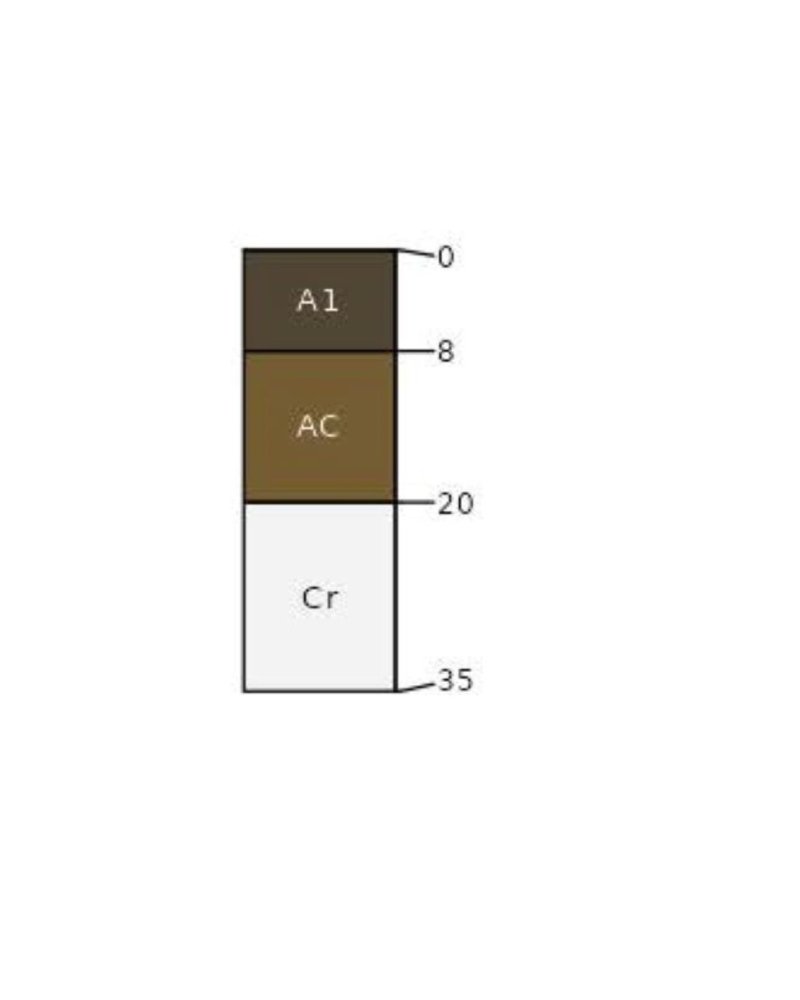
Figure 7. Rooney Series
Table 5. Representative soil features
| Parent material |
(1)
Residuum
–
limestone, sandstone, and shale
|
|---|---|
| Surface texture |
(1) Cobbly, very cobbly, extremely cobbly loam (2) Very stony sandy loam |
| Family particle size |
(1) Sandy over loamy |
| Drainage class | Well drained |
| Permeability class | Moderate |
| Soil depth | 4 – 20 in |
| Surface fragment cover <=3" | 35% |
| Surface fragment cover >3" | 40% |
| Available water capacity (0-20in) |
1 – 4 in |
| Calcium carbonate equivalent (0-20in) |
10% |
| Electrical conductivity (0-20in) |
4 mmhos/cm |
| Sodium adsorption ratio (0-20in) |
Not specified |
| Soil reaction (1:1 water) (0-20in) |
5.6 – 8.4 |
Table 6. Representative soil features (actual values)
| Drainage class | Well drained |
|---|---|
| Permeability class | Very slow to moderately rapid |
| Soil depth | 4 – 20 in |
| Surface fragment cover <=3" | 35% |
| Surface fragment cover >3" | 40% |
| Available water capacity (0-20in) |
1 – 4 in |
| Calcium carbonate equivalent (0-20in) |
10% |
| Electrical conductivity (0-20in) |
4 mmhos/cm |
| Sodium adsorption ratio (0-20in) |
Not specified |
| Soil reaction (1:1 water) (0-20in) |
5.6 – 8.4 |
Ecological dynamics
The Shallow Foothills ecological site is characterized by the Reference, Conifer Dominated, and Deciduous Shrub Dominated states. Transitions between states and their respective communities are primarily driven by natural disturbance regimes, the most significant being periodic drought, grazing that results in chronic defoliation (both natural and agricultural), and fire. The timing and magnitude of these disturbances affect the various stages of the vegetative communities as described in the state and transition model.
The historical fire frequency of the the Palmer Divide LRU ranges from 6 to 10 years (Guyette, et al). The impact of fire over the past 50 years has been relatively insignificant due to wildfire suppression and the lack of acceptance of prescribed fire as a management tool. Prolonged drought, coupled with fire suppression, has increased the frequency and intensity of periodic wildfires in the area.
Timber harvest for fuel and lumber has significantly influenced the appearance of the site today.
Much of this ecological site has been fragmented due to urban development. State and Transition Model Information: A state and transition Model (STM) diagram for this ecological site is depicted in this section. Thorough descriptions of each state, transition, plant community, and pathway are found after the state and transition model. This STM is based on available experimental research, field observations, professional consensus, and interpretations. While based on the best available information, the STM may change over time as knowledge of ecological processes increases.
State and transition model
More interactive model formats are also available.
View Interactive Models
Click on state and transition labels to scroll to the respective text
Ecosystem states
| R2A | - | Forest Stand Improvement. Prescribed Grazing. Prescribed Burning. Range Planting. |
|---|---|---|
| R3A | - | Brush Management. Prescribed Grazing. Range Planting. Prescribed Burning. |
State 1 submodel, plant communities
| 1.2A | - | Prescribed Grazing. Prescribed Burning. |
|---|
State 2 submodel, plant communities
State 3 submodel, plant communities
State 1
Reference
The Reference state of the Shallow Foothill Palmer Divide ecological site is a dynamic state that contains three vegetative communities. These communities fluctuate within the parameters that define the state. Precipitation patterns and management strategies regarding herbivory and the presence or absence of fire are the primary drivers that determine the distribution of these communities throughout this state (Anderson, et al, 1982).
Characteristics and indicators. This state has not been sodbusted or overly eroded and has only slight to moderate vegetative deviation from the historical mixed- grass prairie community.
Resilience management. The Reference state can be maintained by managing herbivory with appropriate stocking rates, and timing and duration of grazing periods. Maintaining a natural fire regime with appropriately timed prescribed burning also contributes to the resilience of this state.
Dominant plant species
-
ponderosa pine (Pinus ponderosa), tree
-
Rocky Mountain juniper (Juniperus scopulorum), tree
-
alderleaf mountain mahogany (Cercocarpus montanus), shrub
-
Gambel oak (Quercus gambelii), shrub
-
big bluestem (Andropogon gerardii), grass
-
sideoats grama (Bouteloua curtipendula), grass
Community 1.1
Bluestem, Ponderosa Pine, and Mountain Mahogany
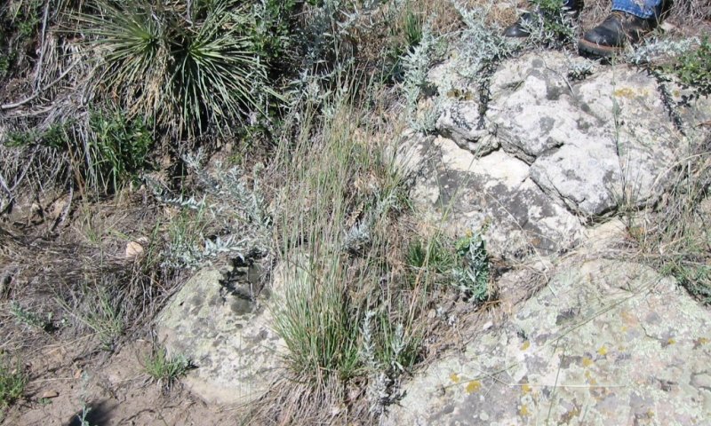
Figure 8. Shallow Foothill, Reference Community, Douglas County, Red Rocks, 7-20-2004
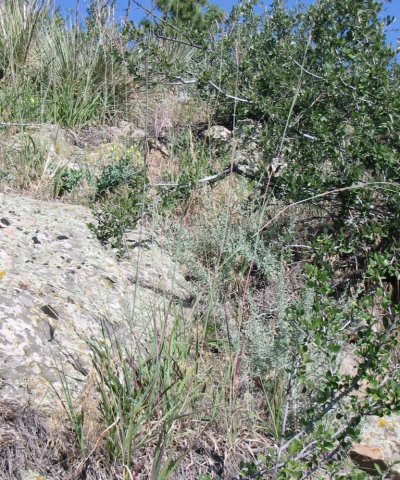
Figure 9. Shallow Foothill, Reference Community, Douglas County, Red Rocks, 7-20-2004
This community developed with grazing by large herbivores and is suited to grazing by domestic livestock. Historically, fires likely occurred infrequently. This plant community is found on areas where grazed plants receive adequate periods of recovery during the growing season. The potential vegetation is about 45 to 70 percent grasses and grass-likes, 10 to 15 percent forbs, 15 to 25 percent shrubs, and 5 to 15 percent tree species. This community displays a wide variety of appearances. A mosaic of grass, shrub or tree dominated areas occur due to variations in parent material, fire history and patterns, climatic extremes, and grazing events. Dominant plants are big bluestem (Andropogon gerardii), little bluestem (Schizachrium scoparium), sideoats grama (Bouteloua curtipendula), Indiangrass (Sorghastrum nutans), mountain mahogany (Cercocarpus montanus), and ponderosa pine (Pinus ponderosa). Secondary plants include blue grama (Bouteloua gracilis), western wheatgrass (pascopyrum smithii), mountain muhly (Muhlenbergia montana), numerous forbs, and Gambel oak (Quercus gambelii). This is a sustainable plant community in terms of site stability, watershed function, and biological integrity. Litter is uniformly distributed where vegetative cover is continuous. Some litter movement may occur on steeper slopes. Decadence and natural plant mortality is low. The biotic community, nutrient cycle, water cycle, and energy flow are functioning properly. Livestock and vehicle trails are subject to water erosion. Total annual production averages1100 pounds per acre during a normal year, and ranges from 500 to 1800.
Resilience management. This community can be maintained by managing herbivory with appropriate stocking rates, timing and duration of grazing periods, and sustainable forestry practices. Maintaining a natural fire regime with appropriately timed prescribed burning also contributes to resilience.
Dominant plant species
-
ponderosa pine (Pinus ponderosa), tree
-
Rocky Mountain juniper (Juniperus scopulorum), tree
-
alderleaf mountain mahogany (Cercocarpus montanus), shrub
-
Gambel oak (Quercus gambelii), shrub
-
big bluestem (Andropogon gerardii), grass
-
sideoats grama (Bouteloua curtipendula), grass
Figure 10. Annual production by plant type (representative values) or group (midpoint values)
Table 7. Annual production by plant type
| Plant type | Low (lb/acre) |
Representative value (lb/acre) |
High (lb/acre) |
|---|---|---|---|
| Grass/Grasslike | 185 | 633 | 1160 |
| Shrub/Vine | 160 | 220 | 300 |
| Tree | 50 | 110 | 170 |
| Forb | 105 | 137 | 170 |
| Total | 500 | 1100 | 1800 |
Community 1.2
Decadent Bluestem, Ponderosa Pine, and Mountain Mahogany
This plant community develops as a result of the lack of the natural disturbances of herbivory and fire. Plant species resemble the 1.1 community, but the frequency and production of the dominant grass species are reduced. Eventually, litter levels can become high enough to cause decadence and mortality of species like big and little bluestem, sideoats grama and Indiangrass. Bunchgrasses typically develop dead centers and rhizomatous grasses can form decadent communities. In advanced stages, plant mortality and the resulting bare areas increase causing an erosion concern. Woody species like Gambel oak, ponderosa pine, and mountain mahogany may increase. As litter increases, nutrient cycling slows. Herbaceous plants lose vigor and eventually die. Total annual production averages 700 pounds of air-dry vegetation per acre during a normal year, and ranges from 300 to 1100.
Resilience management. To sustain this community, occasional light disturbance from herbivory or prescribed fire is recommended.
Dominant plant species
-
ponderosa pine (Pinus ponderosa), tree
-
Rocky Mountain juniper (Juniperus scopulorum), tree
-
alderleaf mountain mahogany (Cercocarpus montanus), shrub
-
Gambel oak (Quercus gambelii), shrub
-
big bluestem (Andropogon gerardii), grass
-
little bluestem (Schizachyrium scoparium), grass
-
sideoats grama (Bouteloua curtipendula), grass
-
dotted blazing star (Liatris punctata), other herbaceous
-
white heath aster (Symphyotrichum ericoides), other herbaceous
-
scarlet globemallow (Sphaeralcea coccinea), other herbaceous
Community 1.3
At Risk Ponderosa Pine, Mountain Mahogany, and Bluestem
This plant community developed under excessive herbivory without providing adequate recovery periods during the growing season. Gambel oak, mountain mahogany, ponderosa pine, and Rocky Mountain juniper have increased in canopy cover. Big bluestem, Indiangrass, Western wheatgrass, little bluestem, and sideoats grama have significantly decreased while blue grama has increased. Purple prairie clover (Dalea purpurea) has decreased, while Louisiana sagewort (Artemesia frigida), hairy false goldaster (Heterotheca villosa), and other less desirable forbs have increased. Continuous browsing by sheep, goats, or deer initially decreases the woody species and increases the grass component. The biotic integrity of this community is in the initial stages of being altered. Grasses are being replaced by woody vegetation. Water and nutrient cycles are at risk of becoming degraded. Total annual production averages 900 pounds of air-dry weight during a normal year, and ranges from 400 to 1600.
Resilience management. Resilience management for this community is to adjust the herbivory impacts through stocking rate, timing, and frequency of the grazing period to prevent further conversion to a woody state.
Dominant plant species
-
ponderosa pine (Pinus ponderosa), tree
-
Rocky Mountain juniper (Juniperus scopulorum), tree
-
alderleaf mountain mahogany (Cercocarpus montanus), shrub
-
Gambel oak (Quercus gambelii), shrub
-
big bluestem (Andropogon gerardii), grass
-
blue grama (Bouteloua gracilis), grass
-
prairie sagewort (Artemisia frigida), other herbaceous
-
hairy false goldenaster (Heterotheca villosa), other herbaceous
Pathway 1.1A
Community 1.1 to 1.2
Lack of disturbances such as herbivory, mowing, and fire transitions this community to the Decadent Bluestem, Ponderosa Pine, and Mountain Mahogany community with excessive litter, low plant density, and increased plant mortality.
Context dependence. The amount of growing season precipitation affects the rate and degree of this community shift.
Pathway 1.1B
Community 1.1 to 1.3
Excessive defoliation without adequate recovery opportunity and reduced fire frequency transitions this community to the At Risk Ponderosa Pine, Mountain Mahogany, and Bluestem community.
Context dependence. The amount of growing season precipitation affects the rate and degree of this community shift.
Pathway 1.2A
Community 1.2 to 1.1
Prescribed grazing with adequate recovery periods between each grazing event and a proper stocking rate restores this community back to the Bluestem, Ponderosa Pine, and Mountain Mahogany community. Prescribed burning accelerates this process.
Context dependence. The amount of growing season precipitation affects the rate and degree of this community shift.
Conservation practices
| Prescribed Burning | |
|---|---|
| Prescribed Grazing |
State 2
Conifer Dominated
The Conifer Dominated Ponderosa Pine State contains one plant community phase.
Characteristics and indicators. The ponderosa pine canopy has increased to 30 to 40 percent and dominates the overstory. Gambel oak, mountain mahogany, and skunkbush sumac (Rhus trilobata) are the dominant shrubs. Fendler threeawn (Aristida purpuea), and sand dropseed (Sporobolus cryptandrus) are the primary native grasses.
Resilience management. Light herbivory and minimal overstory disturbance maintains this state.
Dominant plant species
-
ponderosa pine (Pinus ponderosa), tree
-
Gambel oak (Quercus gambelii), shrub
-
skunkbush sumac (Rhus trilobata), shrub
-
alderleaf mountain mahogany (Cercocarpus montanus), shrub
-
Fendler threeawn (Aristida purpurea var. longiseta), grass
-
sand dropseed (Sporobolus cryptandrus), grass
Community 2.1
Ponderosa Pine, Gambel Oak, and Fendler Threeawn
This plant community typically develops with long-term continuous grazing or long-term non-use in the absence of fire. The ponderosa pine canopy has increased to 30 to 40 percent and dominates the overstory. Gambel oak, mountain mahogany, and skunkbush sumac (Rhus trilobata) are the primary shrubs, and Fendler threeawn (Aristida purpuea), and sand dropseed (Sporobolus cryptandrus) have replaced the more desirable grasses. A remnant of native forbs remain, and introduced grasses and forbs are present. Kentucky bluegrass, smooth bromegrass, cheatgrass, and knapweeds may be present in small amounts. Herbaceous diversity and production have significantly decreased. Energy flow, water cycle, and mineral cycle have been negatively affected. Pine needles have replaced herbaceous litter. Soil erosion is a concern on steeper slopes and exposed areas. Production ranges from 400 to 1500 pounds of air-dry vegetation per acre per year.
Resilience management. Light herbivory and minimal overstory disturbance maintain this community.
Dominant plant species
-
ponderosa pine (Pinus ponderosa), tree
-
Gambel oak (Quercus gambelii), shrub
-
skunkbush sumac (Rhus trilobata), shrub
-
alderleaf mountain mahogany (Cercocarpus montanus), shrub
-
Fendler threeawn (Aristida purpurea var. longiseta), grass
-
sand dropseed (Sporobolus cryptandrus), grass
State 3
Deciduous Shrub Dominated
The Deciduous Shrub Dominated State is characterized by two plant community phases. The Gambel Oak and Mountain Mahogany community and the Gambel Oak community represent the state. Gambel oak has significantly increased, along with mountain mahogany, and dominate the characteristic vegetation. Introduced grasses and forbs are present.
Characteristics and indicators. The Gambel Oak and Mountain Mahogany community and the Gambel Oak community represent the state. Gambel oak has significantly increased, along with mountain mahogany, and dominate the characteristic vegetation. Introduced grasses and forbs are present.
Dominant plant species
-
ponderosa pine (Pinus ponderosa), tree
-
Gambel oak (Quercus gambelii), shrub
-
alderleaf mountain mahogany (Cercocarpus montanus), shrub
-
Fendler threeawn (Aristida purpurea var. longiseta), grass
-
Kentucky bluegrass (Poa pratensis), grass
-
cheatgrass (Bromus tectorum), grass
-
knapweed (Centaurea), other herbaceous
Community 3.1
Gambel Oak and Mountain Mahogany
Timber harvest of ponderosa pine with continuous grazing or a severe fire event with continuous grazing leads to the development of this community. Timber harvest or severe crown fires remove the tree competition and continuous grazing removes the herbaceous competition for moisture, sunlight, and nutrients allowing oak to increase. Mountain mahogany may also increase at a slower rate. Invasive species such as cheatgrass, Kentucky bluegrass (Poa pratensis), and knapweeds ( Centaurea) establish and increase. Plant diversity is reduced and annual production can be highly variable.
Dominant plant species
-
ponderosa pine (Pinus ponderosa), tree
-
Gambel oak (Quercus gambelii), shrub
-
alderleaf mountain mahogany (Cercocarpus montanus), shrub
-
Fendler threeawn (Aristida purpurea var. longiseta), grass
-
Kentucky bluegrass (Poa pratensis), grass
-
cheatgrass (Bromus tectorum), grass
-
knapweed (Centaurea), other herbaceous
Community 3.2
Gambel Oak
This community is predominantly Gambel oak and generally has an understory of Kentucky bluegrass. Remnants of other native species, including mountain mahogany, may be present. Gambel oak dominates for approximately 25 post-fire years, and may persist up to 100 years before canopy suppression by ponderosa pine. Browsing animals, in the absence of fire, can also be utilized to reduce oak competition and increase herbaceous vegetation. Continuous herbivory further reduces native herbaceous remnants. Fire applied to any community that supports Gambel oak will generally increase the oak component. If multiple successive fires occur, a temporary herbaceous cover may develop. Plant diversity is reduced and annual production is highly variable.
Dominant plant species
-
Gambel oak (Quercus gambelii), shrub
-
Kentucky bluegrass (Poa pratensis), grass
Transition T1A
State 1 to 2
Excessive herbivory without adequate recovery opportunity and disruption of the historical fire regime are the drivers of this transition.
Constraints to recovery. The degree of shading and competition for resources by the overstory dictates the ability of the system to recover.
Context dependence. Local precipitation patterns greatly influence the rate and degree of restoration.
Transition T1B
State 1 to 3
Stand replacing fire or timber harvest with excessive herbivory drives the Reference State across an ecological threshold to the Deciduous Shrub Dominated State.
Constraints to recovery. The degree of shading and competition for resources by the overstory dictates the ability of the system to recover.
Context dependence. Local precipitation patterns greatly influence the rate and degree of restoration, as does the presence or absence of native species propagation material.
Restoration pathway R2A
State 2 to 1
Timber harvest or stand replacing fire followed by long-term prescribed grazing facilitates recovery to the Reference State.
Context dependence. The degree of fire and timber harvest, and the ability of the remnant native vegetation to propagate determine the likelihood of success. Growing season precipitation patterns influence the degree of restoration.
Conservation practices
| Prescribed Burning | |
|---|---|
| Prescribed Grazing | |
| Range Planting | |
| Forest Stand Improvement |
Restoration pathway R3A
State 3 to 1
Brush control followed by long-term prescribed grazing facilitates recovery to the Reference state. Prescribed fire helps maintain this restoration.
Context dependence. The amount and timing of growing season precipitation greatly influences the temporal and spatial recovery, as does the presence or absence of native species propagation material.
Conservation practices
| Brush Management | |
|---|---|
| Prescribed Burning | |
| Prescribed Grazing | |
| Range Planting |
Additional community tables
Table 8. Community 1.1 plant community composition
| Group | Common name | Symbol | Scientific name | Annual production (lb/acre) | Foliar cover (%) | |
|---|---|---|---|---|---|---|
|
Grass/Grasslike
|
||||||
| 1 | Warm Season Tall Bunchgrass | 200–380 | ||||
| big bluestem | ANGE | Andropogon gerardii | 165–220 | – | ||
| Indiangrass | SONU2 | Sorghastrum nutans | 35–110 | – | ||
| switchgrass | PAVI2 | Panicum virgatum | 20–75 | – | ||
| 3 | Warm Season Mid Bunchgrass | 100–200 | ||||
| little bluestem | SCSC | Schizachyrium scoparium | 55–165 | – | ||
| sideoats grama | BOCU | Bouteloua curtipendula | 55–165 | – | ||
| mountain muhly | MUMO | Muhlenbergia montana | 55–110 | – | ||
| sand dropseed | SPCR | Sporobolus cryptandrus | 0–10 | – | ||
| 5 | Cool Season Mid Rhizomatous | 50–165 | ||||
| Montana wheatgrass | ELAL7 | Elymus albicans | 20–110 | – | ||
| western wheatgrass | PASM | Pascopyrum smithii | 10–55 | – | ||
| spike fescue | LEKI2 | Leucopoa kingii | 10–20 | – | ||
| 8 | Warm Season Short Bunchgrass | 25–90 | ||||
| blue grama | BOGR2 | Bouteloua gracilis | 20–75 | – | ||
| hairy grama | BOHI2 | Bouteloua hirsuta | 0–10 | – | ||
| Fendler threeawn | ARPUL | Aristida purpurea var. longiseta | 0–10 | – | ||
| 9 | Cool Season Mid Bunchgrass | 20–90 | ||||
| Scribner needlegrass | ACSC11 | Achnatherum scribneri | 10–50 | – | ||
| needle and thread | HECO26 | Hesperostipa comata | 10–30 | – | ||
| Indian ricegrass | ACHY | Achnatherum hymenoides | 0–20 | – | ||
| 10 | Upland Sedges | 20–60 | ||||
| sun sedge | CAINH2 | Carex inops ssp. heliophila | 10–30 | – | ||
| Geyer's sedge | CAGE2 | Carex geyeri | 10–20 | – | ||
| 12 | Cool Season Short Bunchgrass | 10–50 | ||||
| prairie Junegrass | KOMA | Koeleria macrantha | 10–20 | – | ||
| squirreltail | ELELE | Elymus elymoides ssp. elymoides | 0–10 | – | ||
| muttongrass | POFE | Poa fendleriana | 0–10 | – | ||
| Sandberg bluegrass | POSE | Poa secunda | 0–10 | – | ||
|
Shrub/Vine
|
||||||
| 2 | Shrubs | 100–250 | ||||
| alderleaf mountain mahogany | CEMO2 | Cercocarpus montanus | 55–165 | – | ||
| Gambel oak | QUGA | Quercus gambelii | 55–165 | – | ||
| American plum | PRAM | Prunus americana | 10–55 | – | ||
| chokecherry | PRVI | Prunus virginiana | 10–55 | – | ||
| skunkbush sumac | RHTR | Rhus trilobata | 10–55 | – | ||
| wax currant | RICE | Ribes cereum | 10–35 | – | ||
| creeping barberry | MARE11 | Mahonia repens | 10–20 | – | ||
| 6 | Other Shrubs | 15–160 | ||||
| Shrub (>.5m) | 2SHRUB | Shrub (>.5m) | 10–55 | – | ||
| fourwing saltbush | ATCA2 | Atriplex canescens | 0–20 | – | ||
| western sandcherry | PRPUB | Prunus pumila var. besseyi | 0–20 | – | ||
| winterfat | KRLA2 | Krascheninnikovia lanata | 0–20 | – | ||
| broom snakeweed | GUSA2 | Gutierrezia sarothrae | 0–10 | – | ||
| prairie sagewort | ARFR4 | Artemisia frigida | 0–10 | – | ||
| rubber rabbitbrush | ERNAG | Ericameria nauseosa ssp. nauseosa var. glabrata | 0–10 | – | ||
| mountain ninebark | PHMO4 | Physocarpus monogynus | 0–10 | – | ||
| plains pricklypear | OPPO | Opuntia polyacantha | 0–10 | – | ||
| Saskatoon serviceberry | AMAL2 | Amelanchier alnifolia | 0–10 | – | ||
| soapweed yucca | YUGL | Yucca glauca | 0–10 | – | ||
|
Tree
|
||||||
| 4 | Trees | 60–170 | ||||
| ponderosa pine | PIPO | Pinus ponderosa | 55–165 | – | ||
| Rocky Mountain juniper | JUSC2 | Juniperus scopulorum | 10–55 | – | ||
| common hackberry | CEOC | Celtis occidentalis | 10–20 | – | ||
| twoneedle pinyon | PIED | Pinus edulis | 10–20 | – | ||
|
Forb
|
||||||
| 7 | Forbs | 60–100 | ||||
| dotted blazing star | LIPU | Liatris punctata | 20–55 | – | ||
| Forb (herbaceous, not grass nor grass-like) | 2FORB | Forb (herbaceous, not grass nor grass-like) | 10–55 | – | ||
| white heath aster | SYER | Symphyotrichum ericoides | 10–20 | – | ||
| little sunflower | HEPU3 | Helianthus pumilus | 10–20 | – | ||
| scarlet globemallow | SPCO | Sphaeralcea coccinea | 10–20 | – | ||
| winged buckwheat | ERAL4 | Eriogonum alatum | 10–20 | – | ||
| Fremont's geranium | GECAF | Geranium caespitosum var. fremontii | 0–10 | – | ||
| ragwort | SENEC | Senecio | 0–10 | – | ||
| hairy false goldenaster | HEVI4 | Heterotheca villosa | 0–10 | – | ||
| larkspur | DELPH | Delphinium | 0–10 | – | ||
| white sagebrush | ARLU | Artemisia ludoviciana | 0–10 | – | ||
| beardtongue | PENST | Penstemon | 0–10 | – | ||
| upright prairie coneflower | RACO3 | Ratibida columnifera | 0–10 | – | ||
| sulphur-flower buckwheat | ERUM | Eriogonum umbellatum | 0–10 | – | ||
| textile onion | ALTE | Allium textile | 0–10 | – | ||
| 11 | Leguminous Forbs | 10–60 | ||||
| purple prairie clover | DAPUP | Dalea purpurea var. purpurea | 10–30 | – | ||
| Drummond's milkvetch | ASDR3 | Astragalus drummondii | 0–10 | – | ||
| lupine | LUPIN | Lupinus | 0–10 | – | ||
| slimflower scurfpea | PSTE5 | Psoralidium tenuiflorum | 0–10 | – | ||
| twogrooved milkvetch | ASBI2 | Astragalus bisulcatus | 0–10 | – | ||
Interpretations
Animal community
Animal Community – Grazing Interpretations
The following stocking rates are estimates that should be used only as guidelines in the initial stages of the conservation planning process. Often, the current plant composition does not entirely match any particular plant community described in this ecological site description. Steepness of slope and density of shrubs affect accessibility. Because of this, a field visit to take inventory is always recommended.
Plant Community (PC) Production Stocking Rate*
(lbs./acre) (AUM/acre)
1.1 PC 1100 0.30
1.3 PC 900 0.25
1.2 PC 70 0.19
Grazing by domestic livestock is one of the major income-producing industries in the area. Rangelands in this area provide yearlong forage under prescribed grazing for cattle, sheep, horses and other herbivores. During the dormant period, livestock may need supplementation based on reliable forage analysis.
Hydrological functions
Water is the principal factor limiting forage production on this site. This site is dominated by soils in hydrologic group A. Infiltration is moderate to high and runoff potential for this site is moderate depending on ground cover. Areas where ground cover is less than 50 percent have the greatest potential to have reduced infiltration and higher runoff (refer to NRCS Section 4, National Engineering Handbook (NEH-4) for runoff quantities and hydrologic curves).
Recreational uses
This site provides hunting, horseback riding, hiking, photography, bird watching, and other opportunities. The wide varieties of plants that bloom and fall foliage have an aesthetic value that appeal to many.
Wood products
Fence posts, firewood, and lumber are potential wood products.
Other products
Landscape rock.
Other information
NRCS Field Offices:
Colorado: Byers, Colorado Springs, Franktown, Metro (Lakewood), Simla
Counties: Arapahoe, Douglas, Elbert, El Paso, Jefferson
Supporting information
Inventory data references
A minimum of 20 low or medium intensity observations are required to meet verification level status. This ESD is citing NRI and 417 data to meet these minimums. Individual observations are listed in EDIT and are viewable behind the login. A corresponding tracking sheet is available in the MLRA office that links the list to the actual observations used in analysis
References
-
Guyette, R.P., M.C. Stambaugh, D.C. Dey, and R. Muzika. 2012. Predicting Fire Frequency with Chemistry and Climate. Ecosystems 15:322–335.
Other references
Abella, Scott R., 2008. Managing Gambel Oak in southwestern ponderosa pine forests: The status of our knowledge. Faculty Publications (SEPA). Paper 349.University of Nevada, Las Vegas
Allen, Robert B., Robert K. Peet and William L. Baker., 1991. Gradient analysis of latitudinal variation in southern Rocky Mountain forests. Journal of Biogeography 18, 123-139
Andrews, R. and R. Righter. 1992. Colorado Birds. Denver Museum Nat. Hist., Denver, CO. 442 pp.
Armstrong, D.M. 1972. Distribution of mammals in Colorado. Univ. Kansas Museum Nat. Hist. Monograph #3. 415 pp.
Banzhaf, William H., et al., 1986. Gambel Oak in Colorados Front Range. Potentials of noncommercial forest biomass for energy. Excerpt from Univ. of Ariz. School of Renewable Natural Resources. Technical Bulletin No. 256
Colorado Breeding Bird Atlas. 1998. Hugh Kingery, Ed., Dist. CO Wildlife Heritage Found., P.O. Box 211512, Denver, CO, 80221. 636 pp.
Colorado Climate Center. 2010. Monthly Data. Data Access. http://ccc.atmos.colostate.edu/dataaccess.php
Ecological Society of America, 2011. Ecological Applications, 21(6), pp. 2210–2222.
Fitzgerald, J. P., Meaney, C. A., and Armstrong, D. M. 1994. Denver Museum of Natural History and University Press of Colorado. Mammals of Colorado
Hammerson, G. A. 1999. University Press of Colorado. Amphibians and Reptiles in Colorado A Colorado Field Guide
High Plains Regional Climate Center, University of Nebraska, 830728 Chase Hall, Lincoln, NE 68583-0728. (http://hpcc.unl.edu)
Jackson, Donald., 1966 The journals of Zebulon Montgomery Pike with letters & related documents. Univ. of Oklahoma Press, First Edition
Kingery, H. E. 1998. Colorado Breeding Bird Atlas, Colorado Bird Atlas Partnership and Colorado Division of Wildlife
NOAA Western Regional Climate Center, 2215 Raggio Parkway Reno, NV 89512 (http://www.wrcc.dri.edu)
Peet, Robert K., 1978. Forest vegetation of the Colorado Front Range; Patterns of species diversity. Vegetatio Vol. 37, 2: 65-78
Rennicke, J. 1990. Colorado Wildlife. Falcon Press, Helena and Billings, MT and CO Div. Wildlife, Denver CO. 138 pp.
Richardson., 1915. G.B. Geologic atlas of the United States, Castle Rock Folio. U.S. Geologic Survey
Soil Survey Staff, USDA-NRCS Official Soil Series Descriptions. Available online at http://soils.usda.gov/technical/classification/osd/index.html.
Accessed [April 3, 2013].
Soil Survey Staff, USDA-NRCS U.S. General Soil Map (STATSGO2). Available online at http://soildatamart.nrcs.usda.gov. Accessed [April 3, 2013].
USDA, NRCS. Grazing Lands Technology Institute, Revision 1, December 2003, issued September 1997. National Range and Pasture Handbook at http://www.co.nrcs.usda.gov/ Home / Land Use / Range & Pasture / National Range and Pasture Handbook.
USDA, NRCS. National Soil Information System, Information Technology Center, 2150 Centre Avenue, Building A, Fort Collins, CO 80526. http://nasis.nrcs.usda.gov
USDA, NRCS. 2013. The PLANTS Database
(http://plants.usda.gov, 6 September 2013). National Plant Data Team, Greensboro, NC 27401-4901 USA.
USDA-Soil Conservation Service (SCS). Soil Survey of Arapahoe County, Colorado. Issued 1971 in cooperation with Colorado Agricultural Experiment Station. US Government Printing Office
USDA-SCS. Soil Survey of Castle Rock Area, Colorado. Issued 1974 in cooperation with Colorado Agricultural Experiment Station. US Government Printing Office
USDA-SCS. Soil Survey of Elbert County, Colorado, Western Part. Issued 1979 in cooperation with Colorado Agricultural Experiment Station. US Government Printing Office
USDA-SCS. Soil Survey of El Paso County Area, Colorado. Issued 1980 in cooperation with Colorado Agricultural Experiment Station. US Government Printing Office
USDA-NRCS Agriculture Handbook 296, issued 2006. Land Resource Regions and Major Land Resource Areas of the United States, the Caribbean, and the Pacific Basin
NOAA Western Regional Climate Center, 2215 Raggio Parkway, Reno, NV 89512 (http://www.wrcc.dri.edu)
Soil Survey Staff, USDA-NRCS Official Soil Series Descriptions. Available online at http://soils.usda.gov/technical/classification/osd/index.html.
Accessed [April 3, 2013].
Soil Survey Staff, USDA-NRCS U.S. General Soil Map (STATSGO2). Available online at http://soildatamart.nrcs.usda.gov. Accessed [April 3, 2013].
Tania Schoennagel, Rosemary L. Sherrif, and Thomas T. Veblin. Fire history and tree recruitment in the Colorado Front Range upper montane zone: implications for forest restoration
USDA, FS. (www.fs.fed.us/database)
USDA, NRCS. National Range and Pasture Handbook, September 1997
USDA, NRCS. National Soil Information System, Information Technology Center, 2150 Centre Avenue, Building A, Fort Collins, CO 80526. (http://nasis.nrcs.usda.gov)
USDA, NRCS. National Water and Climate Center, 101 SW Main, Suite 1600, Portland, OR 97204-3224. (http://wcc.nrcs.usda.gov)
USDA, NRCS. 2013. The PLANTS Database
(http://plants.usda.gov, 6 September 2013). National Plant Data Team, Greensboro, NC 27401-4901 USA.
Contributors
Revised by Doug Whisenhunt
D.A. Nosal; H.A. Sprock; B.P. Berlinger, K.A. Diller, Lee A. Neve
Approval
Kirt Walstad, 5/08/2025
Acknowledgments
Project Staff:
Ben Berlinger, Rangeland Management Specialist (ret.), NRCS-ACES, Rocky Ford, CO
Kimberly Diller, Ecological Site Inventory Specialist, NRCS MLRA SSO, Pueblo CO
Lee Neve, Project Leader (ret.), NRCS SSO, Pueblo, CO
Laura Craven, Project Leader, NRCS SSO, Pueblo, CO
Partners/Contributors:
Dan Nosal, Rangeland Management Specialist, NRCS, Franktown, CO
Joshua Tashiro, Rangeland Management Specialist, NRCS, Canon City, CO
Josh Saunders, Rangeland Management Specialist, NRCS, Fort Morgan, CO
Andy Steinert, Project Leader, NRCS SSO, Fort Morgan, CO
Program Support:
Rachel Murph, State Rangeland Management Specialist, NRCS SO, Lakewood, CO
Eugene Backhaus, State Resource Conservationist, NRCS SO, Lakewood, CO
Non-discrimination statement
In accordance with Federal civil rights law and U.S. Department of Agriculture (USDA) civil rights regulations and policies, the USDA, its Agencies, offices, and employees, and institutions participating in or administering USDA programs are prohibited from discriminating based on race, color, national origin, religion, sex, gender identity (including gender expression), sexual orientation, disability, age, marital status, family/parental status, income derived from a public assistance program, political beliefs, or reprisal or retaliation for prior civil rights activity, in any program or activity conducted or funded by USDA (not all bases apply to all programs). Remedies and complaint filing deadlines vary by program or incident.
Persons with disabilities who require alternative means of communication for program information (e.g., Braille, large print, audiotape, American Sign Language, etc.) should contact the responsible Agency or USDA's TARGET Center at (202) 720-2600 (voice and TTY) or contact USDA through the Federal Relay Service at (800) 877-8339. Additionally, program information may be made available in languages other than English.
To file a program discrimination complaint, complete the USDA Program Discrimination Complaint Form, AD-3027, found online at How to File a Program Discrimination Complaint and at any USDA office or write a letter addressed to USDA and provide in the letter all of the information requested in the form. To request a copy of the complaint form, call (866) 632-9992. Submit your completed form or letter to USDA by: (1) mail: U.S. Department of Agriculture, Office of the Assistant Secretary for Civil Rights, 1400 Independence Avenue, SW, Washington, D.C. 20250-9410; (2) fax: (202) 690-7442; or (3) email:
program.intake@usda.gov.
Rangeland health reference sheet
Interpreting Indicators of Rangeland Health is a qualitative assessment protocol used to determine ecosystem condition based on benchmark characteristics described in the Reference Sheet. A suite of 17 (or more) indicators are typically considered in an assessment. The ecological site(s) representative of an assessment location must be known prior to applying the protocol and must be verified based on soils and climate. Current plant community cannot be used to identify the ecological site.
| Author(s)/participant(s) | |
|---|---|
| Contact for lead author | |
| Date | 02/07/2025 |
| Approved by | Kirt Walstad |
| Approval date | |
| Composition (Indicators 10 and 12) based on | Annual Production |
Indicators
-
Number and extent of rills:
-
Presence of water flow patterns:
-
Number and height of erosional pedestals or terracettes:
-
Bare ground from Ecological Site Description or other studies (rock, litter, lichen, moss, plant canopy are not bare ground):
-
Number of gullies and erosion associated with gullies:
-
Extent of wind scoured, blowouts and/or depositional areas:
-
Amount of litter movement (describe size and distance expected to travel):
-
Soil surface (top few mm) resistance to erosion (stability values are averages - most sites will show a range of values):
-
Soil surface structure and SOM content (include type of structure and A-horizon color and thickness):
-
Effect of community phase composition (relative proportion of different functional groups) and spatial distribution on infiltration and runoff:
-
Presence and thickness of compaction layer (usually none; describe soil profile features which may be mistaken for compaction on this site):
-
Functional/Structural Groups (list in order of descending dominance by above-ground annual-production or live foliar cover using symbols: >>, >, = to indicate much greater than, greater than, and equal to):
Dominant:
Sub-dominant:
Other:
Additional:
-
Amount of plant mortality and decadence (include which functional groups are expected to show mortality or decadence):
-
Average percent litter cover (%) and depth ( in):
-
Expected annual annual-production (this is TOTAL above-ground annual-production, not just forage annual-production):
-
Potential invasive (including noxious) species (native and non-native). List species which BOTH characterize degraded states and have the potential to become a dominant or co-dominant species on the ecological site if their future establishment and growth is not actively controlled by management interventions. Species that become dominant for only one to several years (e.g., short-term response to drought or wildfire) are not invasive plants. Note that unlike other indicators, we are describing what is NOT expected in the reference state for the ecological site:
-
Perennial plant reproductive capability:
Print Options
Sections
Font
Other
The Ecosystem Dynamics Interpretive Tool is an information system framework developed by the USDA-ARS Jornada Experimental Range, USDA Natural Resources Conservation Service, and New Mexico State University.
Click on box and path labels to scroll to the respective text.
Ecosystem states
| R2A | - | Forest Stand Improvement. Prescribed Grazing. Prescribed Burning. Range Planting. |
|---|---|---|
| R3A | - | Brush Management. Prescribed Grazing. Range Planting. Prescribed Burning. |
State 1 submodel, plant communities
| 1.2A | - | Prescribed Grazing. Prescribed Burning. |
|---|